August 2020 Hot Weather Forecast & Recap
Captain's Log
Captain Kirk is taking a well-deserved vacation with the family this week (well-timed Captain!), so Co-Captain Krissy here at your service. There's a lot going on in the weather department this week so let's dive right into it!
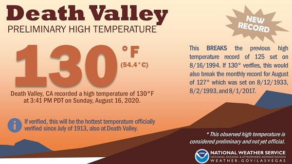
HOT! That sums up what's going on out West where they're in the midst of a long duration heat wave. In fact, we may have seen the hottest day since July of 1913 with an astounding 130F in Death Valley, CA on Sunday, August 16th. If this high temperature observation is confirmed, this will be the tied for the 3rd most reliably measured all-time global high temperature.
Excessive heat will last through much of this week with high temperatures running 8-15F above normal. Temperatures will "cool" only slightly late in the week but temperatures will remain above normal through early next week.
Yes, you read that correctly: Firenado = Fire + Tornado. Why? Mostly because it's 2020, but also because wildfires occasionally can produce pyrocumulonimbus, which is basically a thunderstorm influenced by a fire or volcanic eruption. This past Saturday, the National Weather Service in Reno, NV issued a rare tornado warning for a pyrocumulonimbus that produced a fire-induced tornado over Lassen County, CA, northwest of Reno.
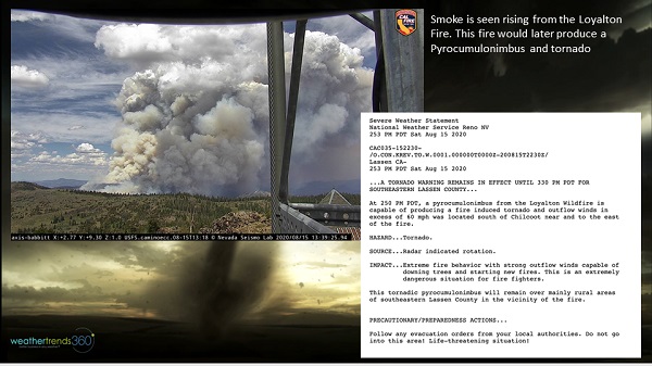
The "Firenado" spawned from the Loyalton Fire in Lassen County. Recent hot conditions combined with ongoing dryness have contributed to elevated wildfire risks in the area. Luckily, the "Firenado" struck a relatively unpopulated area, but was a challenge in the efforts to contain wildfires in the area.
We're entering a dangerous period for the tropical Atlantic as activity is expected to ramp up through the end of August. Currently, we're watching 2 disturbances that could bring some trouble to the Caribbean, Mexico, and the U.S. over the next 5-10 days.
The first system is located over the eastern Caribbean Sea this morning. Although significant development of this system is unlikely over the next couple of days, it could become better organized late this week or weekend as it reaches the northwestern Caribbean Sea. This system could interact with Yucatan, but there is a lot of uncertainty where it heads from there. Locations from the northern Gulf Coast all the way to northeast Mexico should watch the progression of this system.
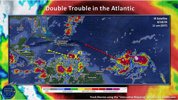
The second system is located about 900 miles west-southwest of the Cabo Verde Islands this morning. It is likely that this system will develop into a tropical depression within the next couple of days. The current path of this system has it skirting the north side of the islands. If it gets too close to the islands, this could weaken the storm, however, should it clear the islands, there is a good chance we could be looking at our next tropical storm or even hurricane. Interests across the Caribbean Islands, Florida, and the U.S. East Coast should monitor the progress of this system.
The Eastern Pacific has seen a recent uptick in activity. Currently, powerful category 4 Hurricane Genevieve is moving just west of the Baja California peninsula. While Genevieve is not expected to make landfall in Mexico, portions of the southern Baja California Sur will see tropical storm conditions. The weather starts to go downhill Wednesday afternoon and into Thursday.
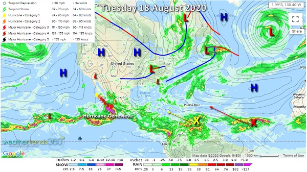
Large swells from Genevieve will impact the coast of Baja California and could bring some larger swells to the U.S. in southern California as well. Thankfully, this dangerously storm is not expected to make landfall. Activity in the Eastern Pacific should quiet down towards the end of August and beginning of September.
Record Heat in the West
HOT! That sums up what's going on out West where they're in the midst of a long duration heat wave. In fact, we may have seen the hottest day since July of 1913 with an astounding 130F in Death Valley, CA on Sunday, August 16th. If this high temperature observation is confirmed, this will be the tied for the 3rd most reliably measured all-time global high temperature.
Excessive heat will last through much of this week with high temperatures running 8-15F above normal. Temperatures will "cool" only slightly late in the week but temperatures will remain above normal through early next week.
Firenado?
Yes, you read that correctly: Firenado = Fire + Tornado. Why? Mostly because it's 2020, but also because wildfires occasionally can produce pyrocumulonimbus, which is basically a thunderstorm influenced by a fire or volcanic eruption. This past Saturday, the National Weather Service in Reno, NV issued a rare tornado warning for a pyrocumulonimbus that produced a fire-induced tornado over Lassen County, CA, northwest of Reno.
The "Firenado" spawned from the Loyalton Fire in Lassen County. Recent hot conditions combined with ongoing dryness have contributed to elevated wildfire risks in the area. Luckily, the "Firenado" struck a relatively unpopulated area, but was a challenge in the efforts to contain wildfires in the area.
Double Trouble Brewing in the Tropical Atlantic
We're entering a dangerous period for the tropical Atlantic as activity is expected to ramp up through the end of August. Currently, we're watching 2 disturbances that could bring some trouble to the Caribbean, Mexico, and the U.S. over the next 5-10 days.
The first system is located over the eastern Caribbean Sea this morning. Although significant development of this system is unlikely over the next couple of days, it could become better organized late this week or weekend as it reaches the northwestern Caribbean Sea. This system could interact with Yucatan, but there is a lot of uncertainty where it heads from there. Locations from the northern Gulf Coast all the way to northeast Mexico should watch the progression of this system.
The second system is located about 900 miles west-southwest of the Cabo Verde Islands this morning. It is likely that this system will develop into a tropical depression within the next couple of days. The current path of this system has it skirting the north side of the islands. If it gets too close to the islands, this could weaken the storm, however, should it clear the islands, there is a good chance we could be looking at our next tropical storm or even hurricane. Interests across the Caribbean Islands, Florida, and the U.S. East Coast should monitor the progress of this system.
Meanwhile In the Eastern Pacific
The Eastern Pacific has seen a recent uptick in activity. Currently, powerful category 4 Hurricane Genevieve is moving just west of the Baja California peninsula. While Genevieve is not expected to make landfall in Mexico, portions of the southern Baja California Sur will see tropical storm conditions. The weather starts to go downhill Wednesday afternoon and into Thursday.
Large swells from Genevieve will impact the coast of Baja California and could bring some larger swells to the U.S. in southern California as well. Thankfully, this dangerously storm is not expected to make landfall. Activity in the Eastern Pacific should quiet down towards the end of August and beginning of September.