Captain's Log 18 Dec '23 - Much Warmer Leading Up to Christmas Than Last Year
Captain's Log
Captain Kirk is taking a well-deserved vacation, so space station commander Klinger is reporting for duty!
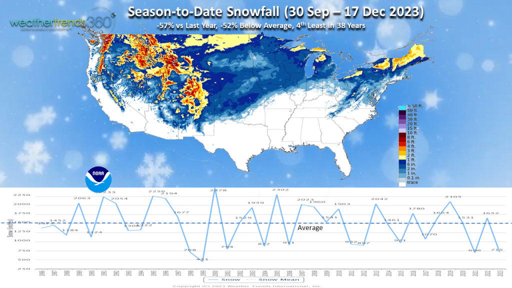
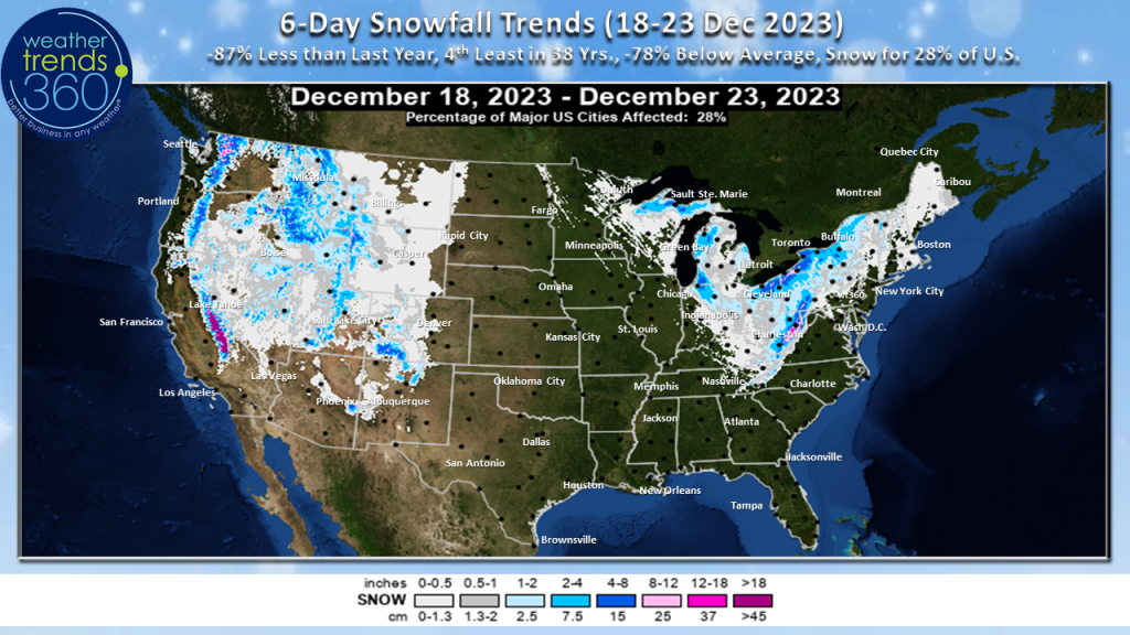
For snow lovers the season continues to be underwhelming. Season snowfall through December 17th is running well below both last year and average for the United States and this is the 4th least season-to-date snowfall for the country as a whole in 38 years.
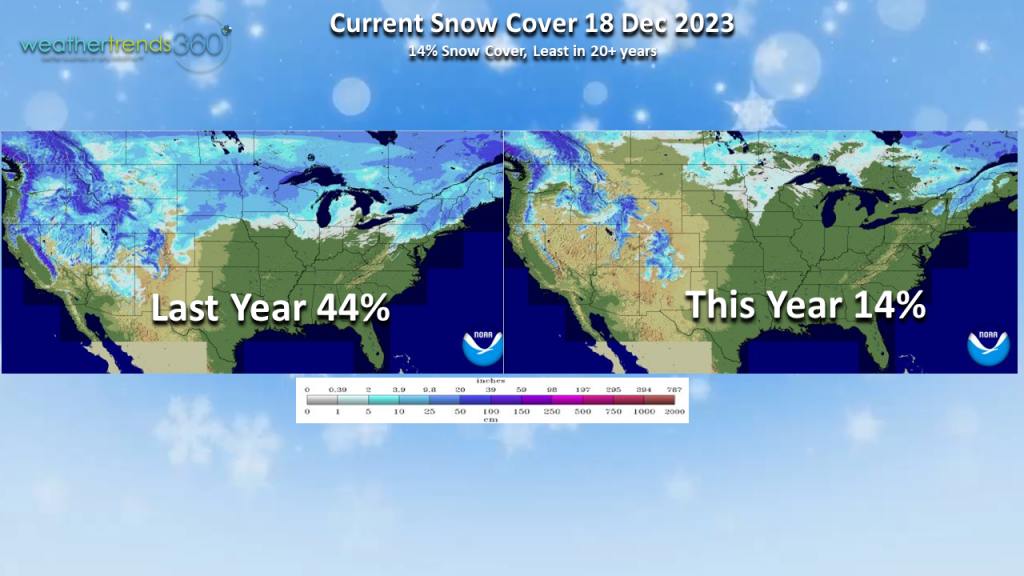
Snow coverage as of this blog posting is a dismal 14% across the lower country. Compare that to last year's 44% snow coverage.
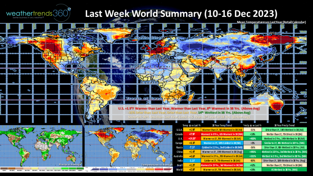
Taking a look across the world, the week-ending December 16th trended warmer than last year and warmer than normal with precipitation trending the greatest in 38 years.
Brazil continued to trend very warm, trending the 3rd warmest in 38 years. Stifling heat and unusually dry weather in the important soybean-growing region of Central-West Brazil (this is their monsoon season) was bad news for crops with some farmers forced to replant. Conditions haven't been as bad in southern Brazil.
Northern Europe was quite mild for this time of year, and significantly warmer than this time last year when cold weather and wintry precipitation brought challenging travel conditions to portions of the region. Meanwhile, Russia's the cold spot trending the 2nd coldest in 38 years.
Northern Australia's Queensland state saw exceptional rainfall in the past week due to Tropical Cyclone Jasper. In fact, the city of Cairns has received several FEET worth of rainfall since they started to be affected by Jasper. Rain continues into this week which will hamper rescue efforts as people remained stranded on rooftops after the heaviest rainfall in decades caused riverways to flood.
We're down to the wire now as we enter the last full week before Christmas. Fortunately for those of us guilty of waiting to the last minute to shop (certainly not me
..) the weather will be MUCH more cooperative than it was last year across the eastern half of the nation. Recall that last year, the last few days before Christmas featured a disruptive winter storm from the Rockies to the East Coast which was followed by a blast of Arctic air that reached all the way to the Deep South. This year couldn't be any more different. This year will be one of the warmest weeks prior to Christmas in 38 years for the nation as a whole!
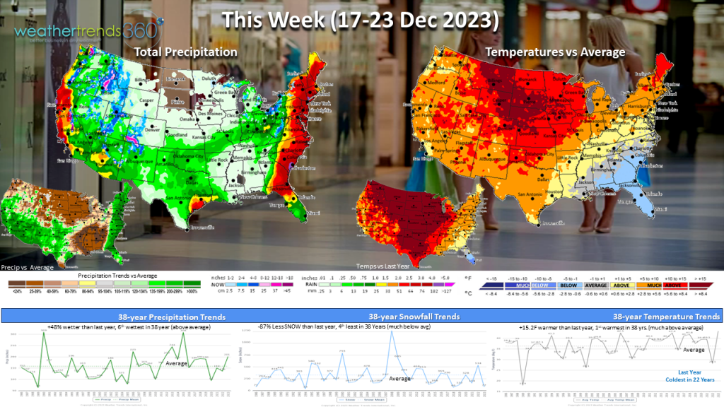
The week starts out a bit difficult with a storm system moving up along the East Coast causing flooding and power outages as winds kick up. The storm exits the Northeast late Monday. Behind this storm, the lake-effect snow machine will kick into gear bringing accumulating snow downwind of the Great lakes to the Appalachians. Be careful if you must travel in these regions Monday afternoon into Tuesday. The snow has already caused some traffic accidents on an interstate in Michigan. The snow is short-lived, however, and by mid-week we should be enjoying dry conditions across the eastern half of the nation.
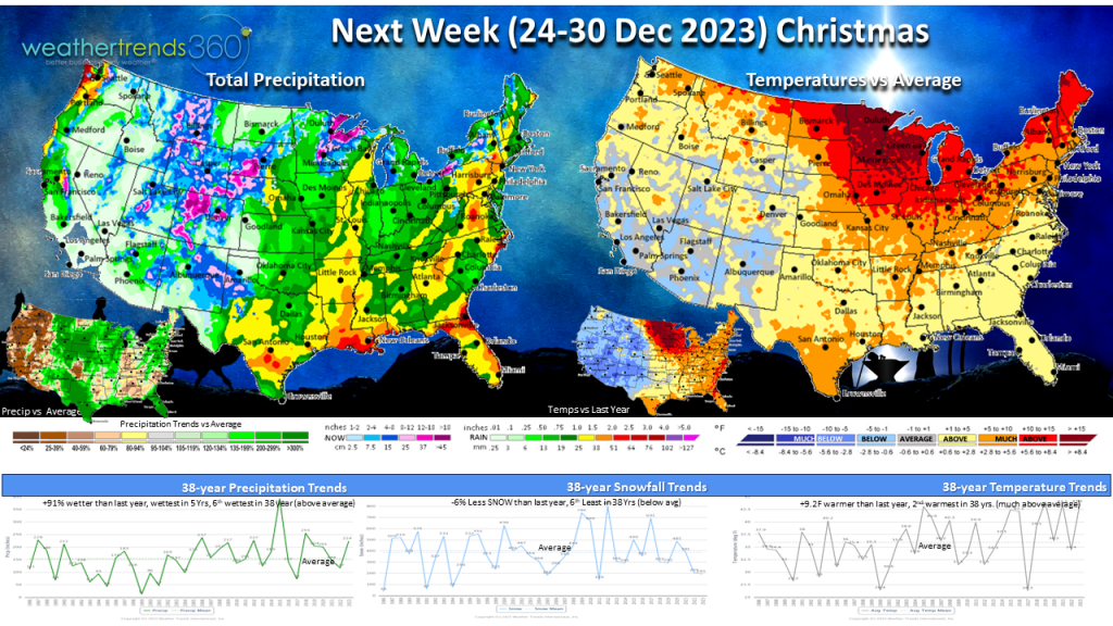
Meanwhile, back-to-back storm systems will bring cloudy and wet weather to the Southwest. The stronger of the storms moves through Wednesday into Thursday with threats for flooding and thunderstorms. Moisture will move into the Central U.S. over the Christmas weekend. There could even be some thunderstorms in the South, near the Gulf Coast. So if you hear a thud Christmas Eve night, it might not be Santa but thunder!
Unfortunately for those wishing for a white Christmas, that dream will not be fulfilled for too many of us across the U.S. The weather looks to be unsettled but rainfall will be the dominant precipitation type across the eastern half of the U.S. You may have a little more luck in the Rockies and perhaps even into the northern Plains and Upper Midwest.
Temperatures will once again trend well above average and this will be one of the warmest final weeks of December in 38 years for the nation as a whole.
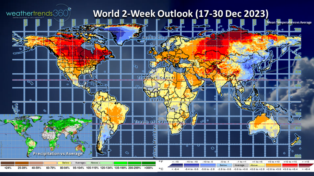
In the global 2-week outlook, we see still plenty of above normal warmth across North America and Europe. Unfortunately, rainfall trends above normal for Queensland again this week as heavy rain lingers.
Space Commander Klinger wishing you the happiest of holidays.
For snow lovers the season continues to be underwhelming. Season snowfall through December 17th is running well below both last year and average for the United States and this is the 4th least season-to-date snowfall for the country as a whole in 38 years.
Snow coverage as of this blog posting is a dismal 14% across the lower country. Compare that to last year's 44% snow coverage.
Taking a look across the world, the week-ending December 16th trended warmer than last year and warmer than normal with precipitation trending the greatest in 38 years.
Brazil continued to trend very warm, trending the 3rd warmest in 38 years. Stifling heat and unusually dry weather in the important soybean-growing region of Central-West Brazil (this is their monsoon season) was bad news for crops with some farmers forced to replant. Conditions haven't been as bad in southern Brazil.
Northern Europe was quite mild for this time of year, and significantly warmer than this time last year when cold weather and wintry precipitation brought challenging travel conditions to portions of the region. Meanwhile, Russia's the cold spot trending the 2nd coldest in 38 years.
Northern Australia's Queensland state saw exceptional rainfall in the past week due to Tropical Cyclone Jasper. In fact, the city of Cairns has received several FEET worth of rainfall since they started to be affected by Jasper. Rain continues into this week which will hamper rescue efforts as people remained stranded on rooftops after the heaviest rainfall in decades caused riverways to flood.
We're down to the wire now as we enter the last full week before Christmas. Fortunately for those of us guilty of waiting to the last minute to shop (certainly not me
..) the weather will be MUCH more cooperative than it was last year across the eastern half of the nation. Recall that last year, the last few days before Christmas featured a disruptive winter storm from the Rockies to the East Coast which was followed by a blast of Arctic air that reached all the way to the Deep South. This year couldn't be any more different. This year will be one of the warmest weeks prior to Christmas in 38 years for the nation as a whole!
The week starts out a bit difficult with a storm system moving up along the East Coast causing flooding and power outages as winds kick up. The storm exits the Northeast late Monday. Behind this storm, the lake-effect snow machine will kick into gear bringing accumulating snow downwind of the Great lakes to the Appalachians. Be careful if you must travel in these regions Monday afternoon into Tuesday. The snow has already caused some traffic accidents on an interstate in Michigan. The snow is short-lived, however, and by mid-week we should be enjoying dry conditions across the eastern half of the nation.
Meanwhile, back-to-back storm systems will bring cloudy and wet weather to the Southwest. The stronger of the storms moves through Wednesday into Thursday with threats for flooding and thunderstorms. Moisture will move into the Central U.S. over the Christmas weekend. There could even be some thunderstorms in the South, near the Gulf Coast. So if you hear a thud Christmas Eve night, it might not be Santa but thunder!
Unfortunately for those wishing for a white Christmas, that dream will not be fulfilled for too many of us across the U.S. The weather looks to be unsettled but rainfall will be the dominant precipitation type across the eastern half of the U.S. You may have a little more luck in the Rockies and perhaps even into the northern Plains and Upper Midwest.
Temperatures will once again trend well above average and this will be one of the warmest final weeks of December in 38 years for the nation as a whole.
In the global 2-week outlook, we see still plenty of above normal warmth across North America and Europe. Unfortunately, rainfall trends above normal for Queensland again this week as heavy rain lingers.
Space Commander Klinger wishing you the happiest of holidays.