Captain's Log 18 Feb '23 Very Snowy Pattern into March!
Captain's Log
18 February 2023 Happy Saturday. :)
The global weather pattern is making a huge 4-year cycle change after 3 years of a La Nina cycle. No doubt we're headed for an El Nino cycle as the evidence is already showing up in the weather pattern. CLICK ON IMAGES FOR A LARGER VIEW.
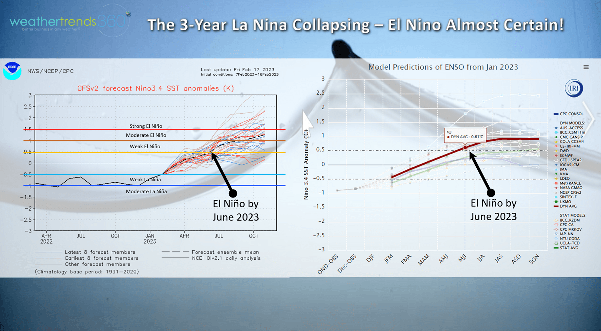
Computer model guidance are in general consensus that El Niño (warmer than average Equatorial Pacific Ocean temperatures) will be here by late Spring and continue through all of 2023.

The year-over-year ocean temperatures show this transition well with much warmer waters in the Eastern Pacific Ocean and cooling in the Indian Ocean.
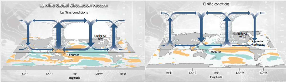
This is just one of many cycles we factor in, but they're important as the underlying water temperatures dramatically alter the global circulation patterns at the surface and aloft. This transition will start to bring drought toward Asia, Malaysia, India and Australia, while excessively wet conditions return to North and South America over the next two years. La Nina's bring sinking air to much of the U.S. in part why drought peaked at 85% of the country late last year.
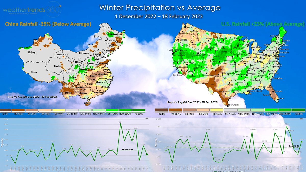
Looking at Winter rainfall shows evidence of this cycle shift with the U.S. having the wettest Winter in 3 year, +23% above average while China has transitioned to dry conditions and -35% below average. They had a very wet cycle for 6 of the past 7 years, that's ending!

The wt360 outlook for India shows the driest conditions in 8 years for the May - October 2023 period. This will further complicate the food supply chain as drought will not be favorable for India's crops like Sugar. wt360 PhD Michael Ferrari will be speaking in India later this week on the implications for agriculture.
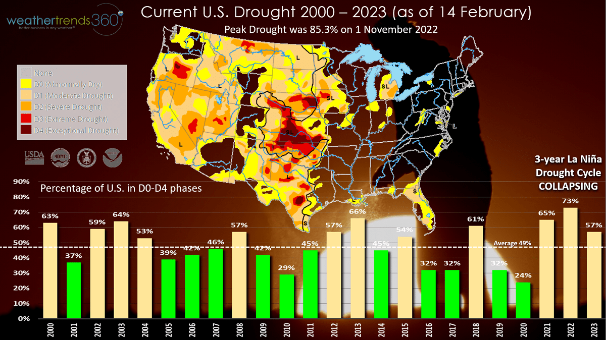
The U.S. now has 57% of the country in dry to drought phases, a huge improvement from the near record 85% back in early November last year. This wet trend will continue throughout 2023 and even into 2024!
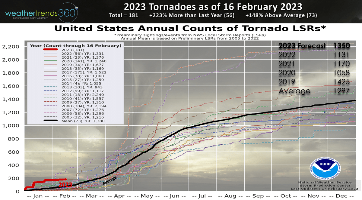
One big negative to this cycle change is going to be tornadic activity. With more frequent cold fronts this Spring/Summer, the clash of airmasses will make for a very active season. wt360 projecting at least a +19% increase over last year. The season to date totals are already off to a very fast start trending +223% more than last year and +148% above average.
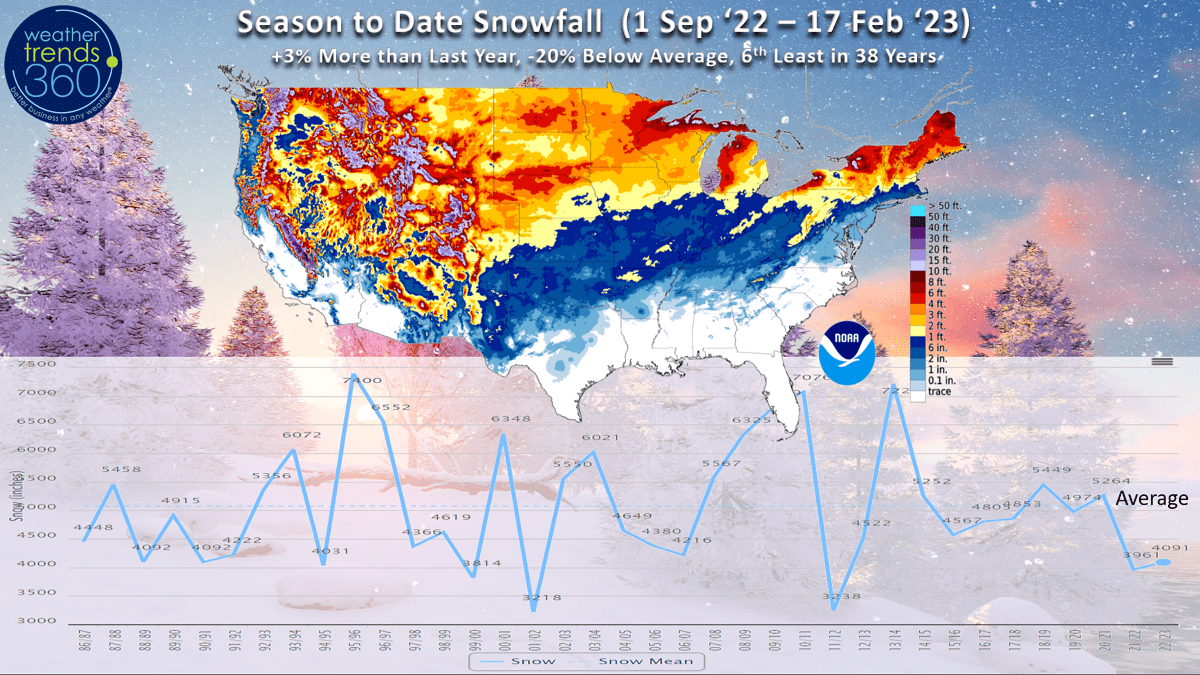
La Nina's are famous for below average snowfall in the U.S. and that's certainly been the case for the U.S. overall despite the heavier totals in the high elevations of the West and the Upper Midwest. Season to date snowfall is still +3% over last year, but that's -20% below average and the 6th least snowfall in 38 years. Record low snow totals from DC to NYC.
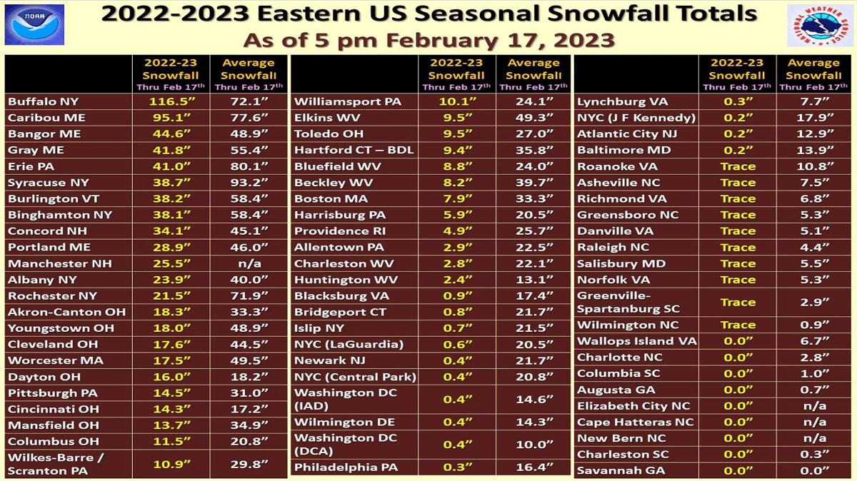
Northeast snow totals are well below average for all but Buffalo NY and far northern Maine.
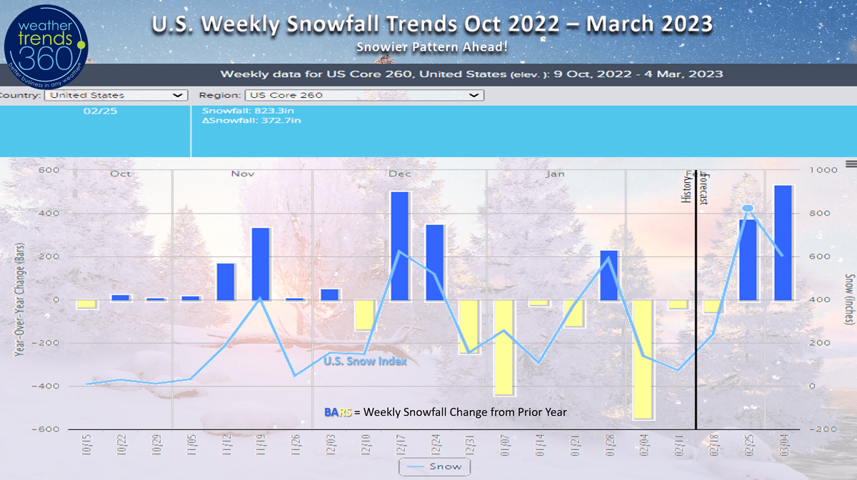
U.S. weekly snowfall trends show the middle December Christmas period was the snowiest of Winter so far, but it appears a very snowy pattern for late February into March will take the snowiest week spot.

Last week (12-18 Feb) around the World shows the U.S. trending +3.9F warmer than last year, warmest in 5 years and 13th warmest in 38 years. Same general theme of very warm East, cold West. Rainfall was +16% wetter than last year and 19th driest of the past 38 years - about average. Snowfall was down -21% vs last year, least in 3 years and 15th least of the past 38 years. Canada was also warm, warmest in 6 years. Warmer and drier weather this time of year is better for overall retail store traffic, especially around holiday periods this week.
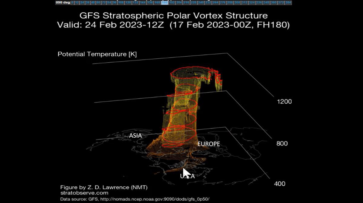
But, this is changing a bit as the Polar Vortex is weakening and more erratic which allows cold Arctic air to move into the mid latitudes. Some of that is heading to the U.S. again favoring the West to Midwest with occasional quick hits in the Northeast. With a very active wet stormy pattern developing in the U.S. the chances for bigger widespread snowstorms appear much more likely later this week into early March. Great opportunity ahead for any snow category clearance sales.
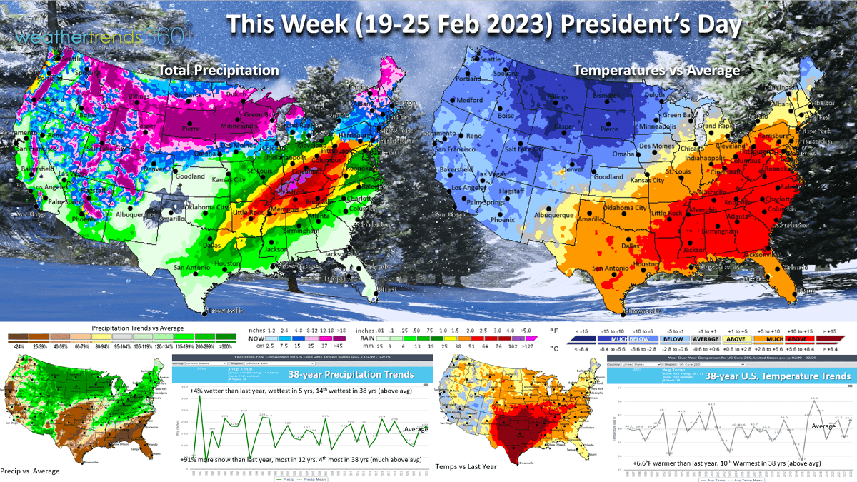
This week (19-25 Feb) shows the U.S. still trending +6.6F warmer than last year, 10th warmest of the past 38 years. Very mild South and East while some of the Arctic air invades the Northern tier of the U.S. The battle ground between the milder air in the Southeast will set up the potential for very heavy snowfall in the Plains and Upper Midwest and POSSIBLY the Northeast next weekend. Rainfall looks to be up +4% over last year, wettest in 5 years and 14th wettest in 38 years. The dry spots are California, Southern Plains and Southeast. Snowfall up +91%, most in 12 years and 4th most in 38 years. This should be the snowiest week of Winter eclipsing the middle December period!
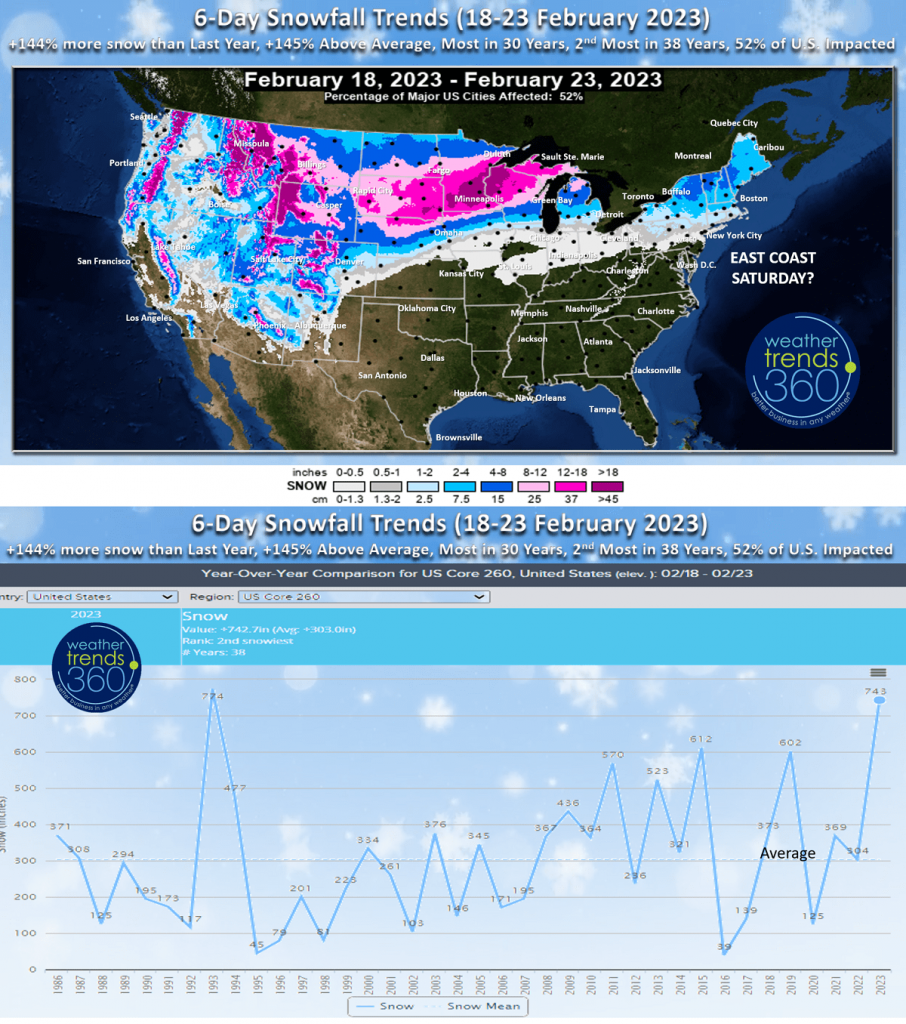 The 6-day snowfall outlook shows the widespread snow with 52% of the U.S. impacted. The snow potential for the Northeast next weekend is just beyond this 6-day forecast period.
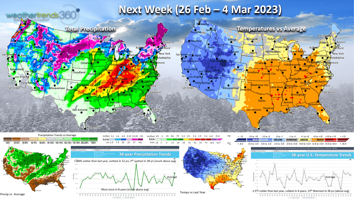
Next week (26 Feb - 4 Mar) While the Polar Vortex cold favors the Western half of the U.S. it could be just cold enough for a snowier pattern in the Northeast, but things will have to line up perfectly to get a bigger snow event. The U.S. overall trends -1.5F colder than last year, coldest in 4 years to start March but 13th warmest of the past 38 years. The wet pattern appears to continue with +186% more precipitation than last year, most in 12 years and 5th most in 38 years. Dry spots from California to the Gulf Coast and Southeast. Snowfall likely to be the most in 8 years and much above average. March is likely to be the coldest and snowiest in 4 years, a big negative for retail sales and your heating bills!
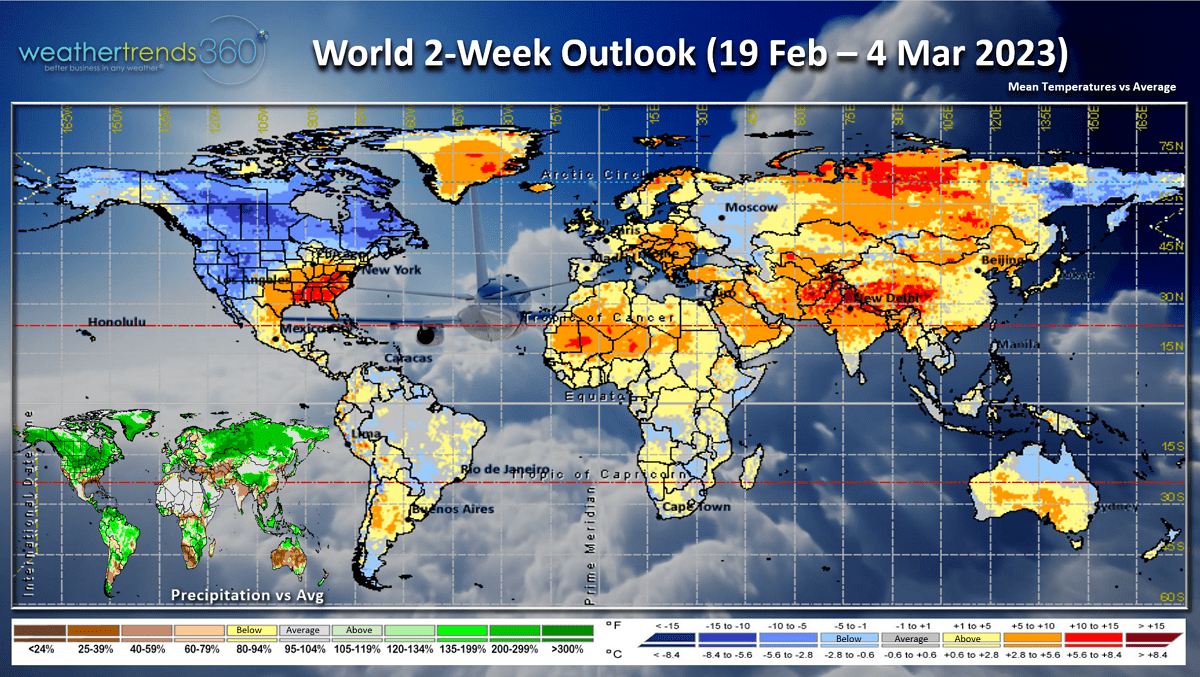
The 2-week World (19 Feb - 4 Mar) outlook shows the Polar Vortex favoring Northeast Siberia, Alaska, Canada and the Western half of the U.S.
We hope you have a great week, and don't forget to follow us on social media for frequent updates: Facebook, Twitter, YouTube, Pinterest and Linkedin.
- Captain Kirk out. (USAF Gulf War Veteran 1989-1999)