Captain's Log 18 May '24 Wet & Stormy Continues
Captain's Log
18 May 2024: Happy Saturday! :)
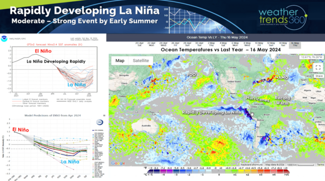
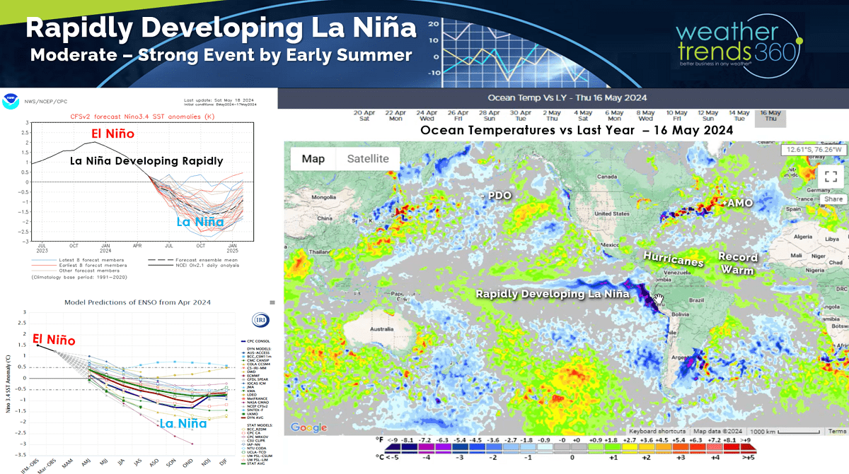
La Niña rapidly developing as the Equatorial Pacific Ocean now trends below average. The atmosphere will lag the climate cycle transition but conditions are already favorable for the start of the 2024 hurricane season. CLICK ON IMAGES FOR A LARGER VIEW.
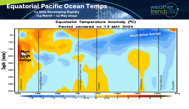
The sub-surface ocean temperatures show a large pool of colder than typical waters moving up to the surface of the Eastern Equatorial Pacific Ocean. Expecting La Niña to peak this Fall and then transition to a Neutral Ocean phase into 2025. This is expected to bring a much colder Winter ahead and with a 4 trillion gallons of extra water vapor from the Jan 2022 Tonga volcano eruption, snowfall should be up significantly.
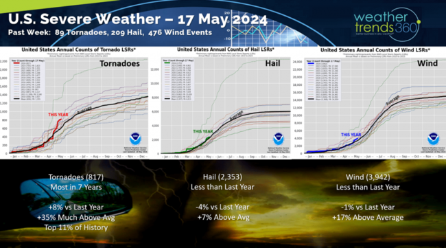
On the severe weather front, we added another 89 tornadoes, 209 hail events and 476 wind events. Tornadoes are now the most in 7 years, +8% vs last year, +17% above average and in the top 11% of historical records. A trend likely to continue for the next 45 days.
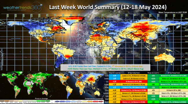
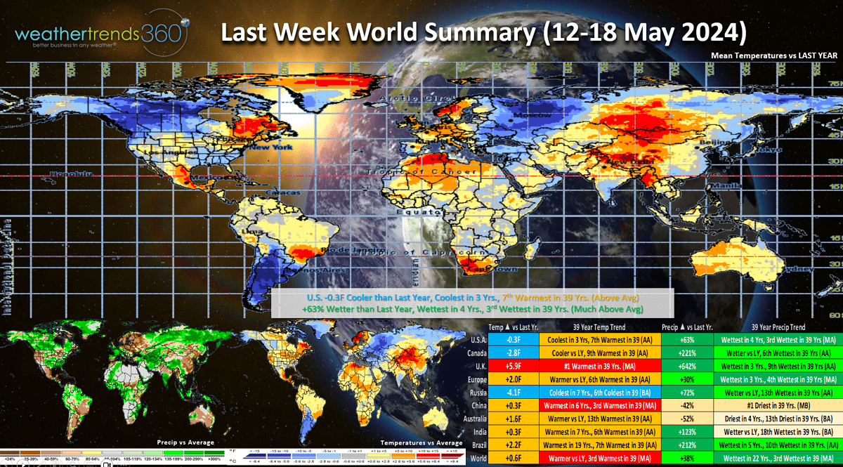
Last Week (12-18 May) across the World shows the U.S. trending -0.3F cooler than last year, coolest in 3 years but 7th warmest of the past 39 years. This was the second week in a row to trend cooler than last year. Unfortunately the wet pattern continues with rainfall up +63% vs last year, most in 4 years and 3rd most in 39 years. While the Northeast had much warmer conditions than last year, the weekends have been the least favorable period with cooler and wetter conditions.
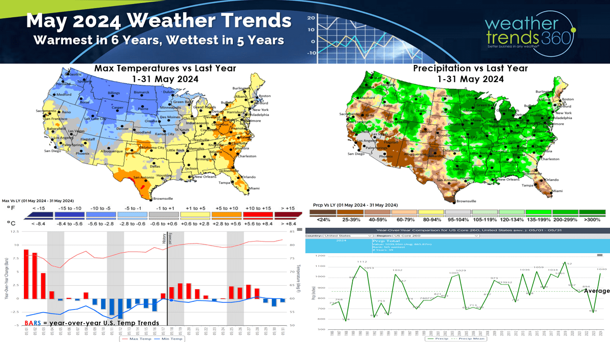
This time of year, warmer and drier year-over-year conditions are more favorable for seasonal category sales and store traffic so it was once again a tough week for retail. May 1-31 is trending the warmest in 6 years nationally but also the wettest in 5 years with much wetter conditions from the Central U.S. to the East Coast.
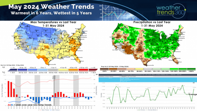
Florida and the Southwest trending drier while the Northeast and Upper Plains are trending much cooler than a year ago.
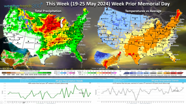
This Week (19-25 May) before Memorial Day Weekend shows a dangerous setup for severe weather with cold weather in the Northwest - Upper Plains and very warm humid air from Texas to Maine. This clash of airmasses will lead to more severe weather that will shift back in the Central Plains and Midwest. For the U.S. overall the week finally trends +2.1F warmer than a year ago, warmest in 3 years and 5th warmest in 39 years. Rainfall is also up +49% vs a year ago and 16th wettest of the past 39 years. Very heavy rainfall where they needed it in the Upper Midwest, but that's putting a damper on farm planting season.
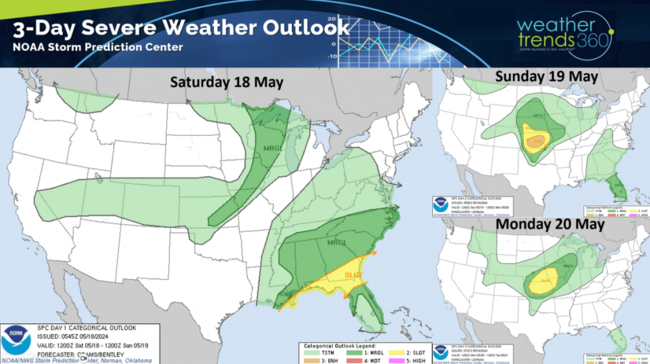
The 3-day severe weather outlook shows the shifting pattern from the Deep South back into the Central Plains - Midwest.
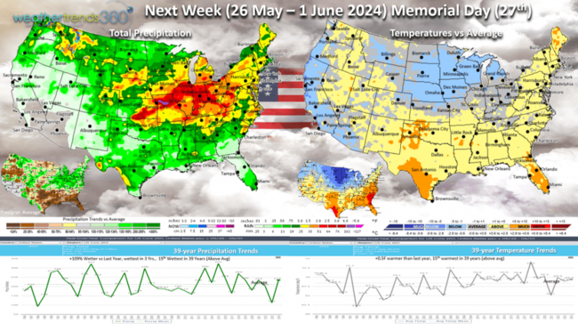
Next Week (26 May - 1 June) shows temperatures trending +0.5F warmer than last year and 15th warmest of the past 39 years, while rainfall is up +109% vs a year ago, wettest in 3 years and also 15th wettest of the past 39 years. The Southeast looks to get a reprieve from the flooding rains, so an uptick in seasonal sales and clean up storm related merchandise.
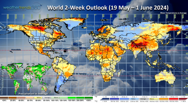
The World 2-week outlook (19 May - 1 Jun) shows the Eastern U.S., Coastal areas of Canada, Central Europe, China and India all trending much warmer which will help seasonal sales a bit. Rainfall is still the dampening factor.

Rainfall totals over 4-5" possible in the Heart Land which will likely delay farmers in the final stages of planting.
We hope you have a great week ahead, and don't forget to follow us on social media for frequent updates: Twitter, YouTube, Pinterest and Linkedin.
Captain Kirk out.
La Niña rapidly developing as the Equatorial Pacific Ocean now trends below average. The atmosphere will lag the climate cycle transition but conditions are already favorable for the start of the 2024 hurricane season. CLICK ON IMAGES FOR A LARGER VIEW.
The sub-surface ocean temperatures show a large pool of colder than typical waters moving up to the surface of the Eastern Equatorial Pacific Ocean. Expecting La Niña to peak this Fall and then transition to a Neutral Ocean phase into 2025. This is expected to bring a much colder Winter ahead and with a 4 trillion gallons of extra water vapor from the Jan 2022 Tonga volcano eruption, snowfall should be up significantly.

On the severe weather front, we added another 89 tornadoes, 209 hail events and 476 wind events. Tornadoes are now the most in 7 years, +8% vs last year, +17% above average and in the top 11% of historical records. A trend likely to continue for the next 45 days.

Last Week (12-18 May) across the World shows the U.S. trending -0.3F cooler than last year, coolest in 3 years but 7th warmest of the past 39 years. This was the second week in a row to trend cooler than last year. Unfortunately the wet pattern continues with rainfall up +63% vs last year, most in 4 years and 3rd most in 39 years. While the Northeast had much warmer conditions than last year, the weekends have been the least favorable period with cooler and wetter conditions.
This time of year, warmer and drier year-over-year conditions are more favorable for seasonal category sales and store traffic so it was once again a tough week for retail. May 1-31 is trending the warmest in 6 years nationally but also the wettest in 5 years with much wetter conditions from the Central U.S. to the East Coast.
Florida and the Southwest trending drier while the Northeast and Upper Plains are trending much cooler than a year ago.
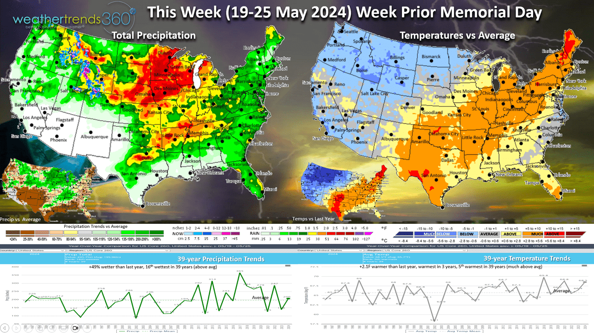
This Week (19-25 May) before Memorial Day Weekend shows a dangerous setup for severe weather with cold weather in the Northwest - Upper Plains and very warm humid air from Texas to Maine. This clash of airmasses will lead to more severe weather that will shift back in the Central Plains and Midwest. For the U.S. overall the week finally trends +2.1F warmer than a year ago, warmest in 3 years and 5th warmest in 39 years. Rainfall is also up +49% vs a year ago and 16th wettest of the past 39 years. Very heavy rainfall where they needed it in the Upper Midwest, but that's putting a damper on farm planting season.
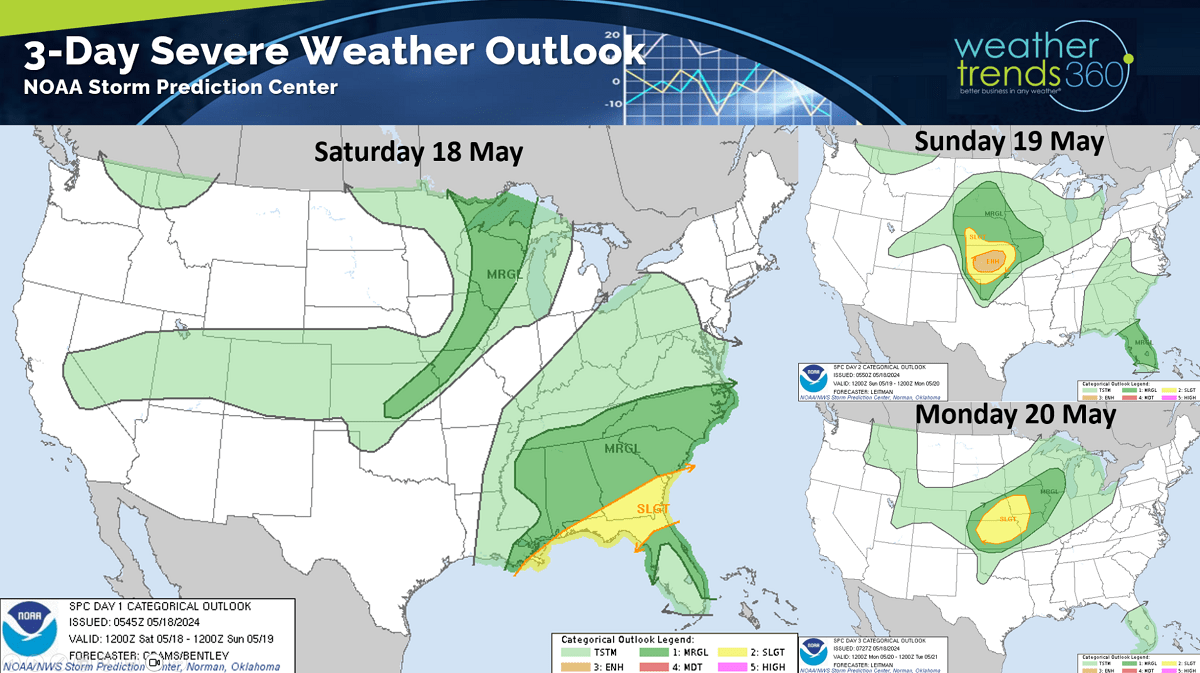
The 3-day severe weather outlook shows the shifting pattern from the Deep South back into the Central Plains - Midwest.
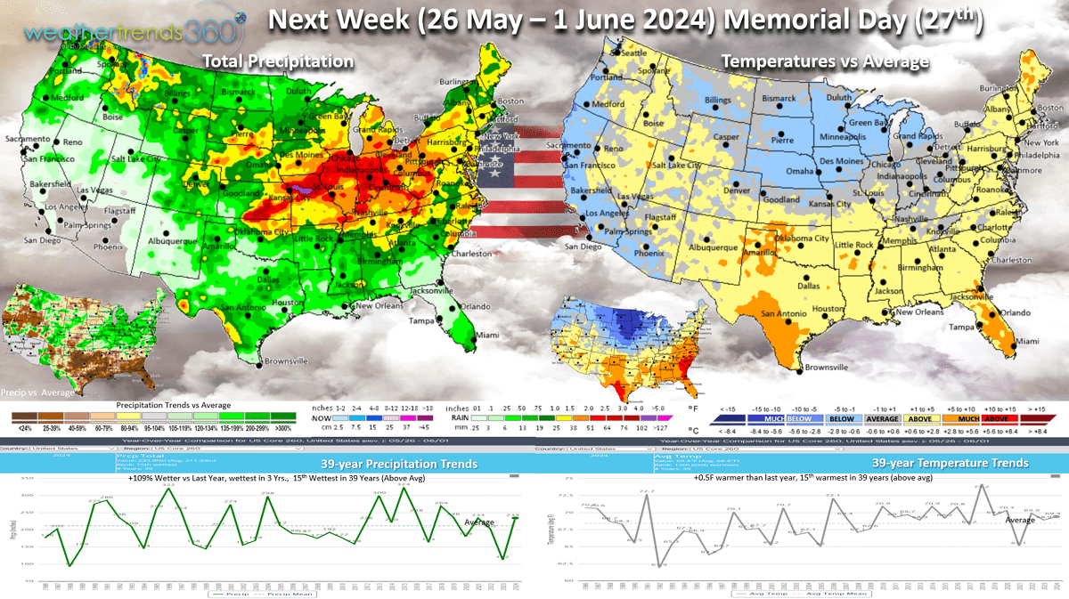
Next Week (26 May - 1 June) shows temperatures trending +0.5F warmer than last year and 15th warmest of the past 39 years, while rainfall is up +109% vs a year ago, wettest in 3 years and also 15th wettest of the past 39 years. The Southeast looks to get a reprieve from the flooding rains, so an uptick in seasonal sales and clean up storm related merchandise.
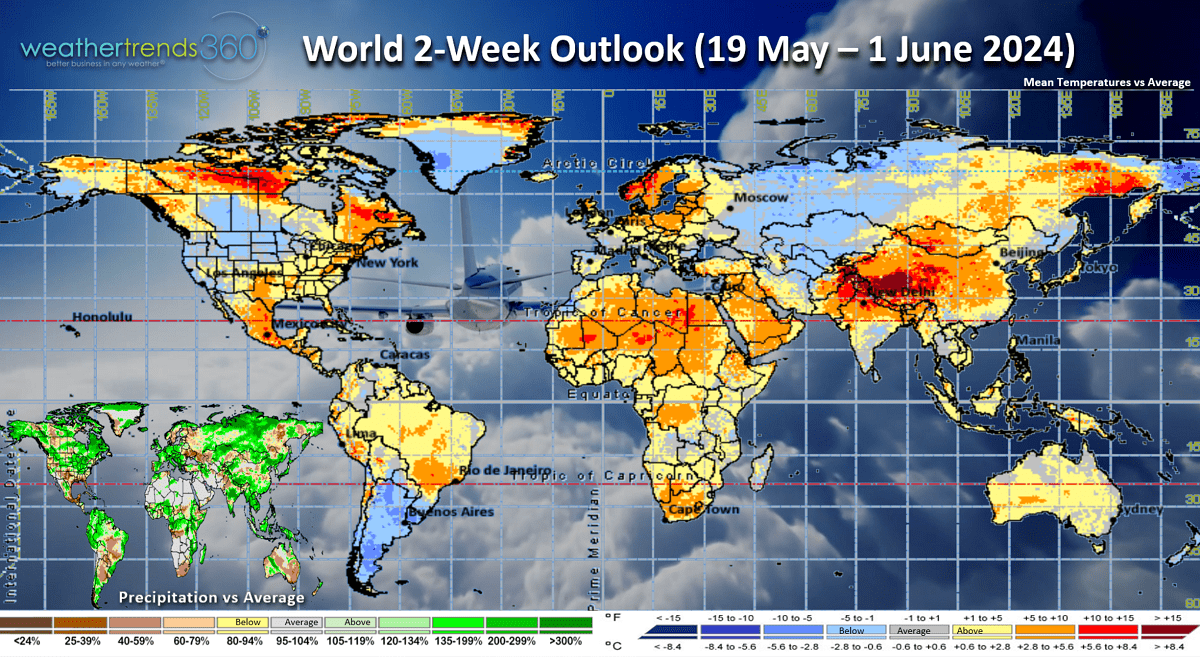
The World 2-week outlook (19 May - 1 Jun) shows the Eastern U.S., Coastal areas of Canada, Central Europe, China and India all trending much warmer which will help seasonal sales a bit. Rainfall is still the dampening factor.
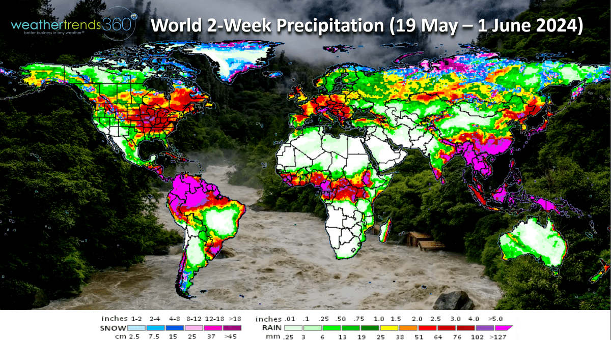
Rainfall totals over 4-5" possible in the Heart Land which will likely delay farmers in the final stages of planting.
We hope you have a great week ahead, and don't forget to follow us on social media for frequent updates: Twitter, YouTube, Pinterest and Linkedin.
Captain Kirk out.