Captain's Log 20 Jan '24 Polar Vortex Retreating - Major Warm up!
Captain's Log
20 Jan 2024: Happy Saturday! :)
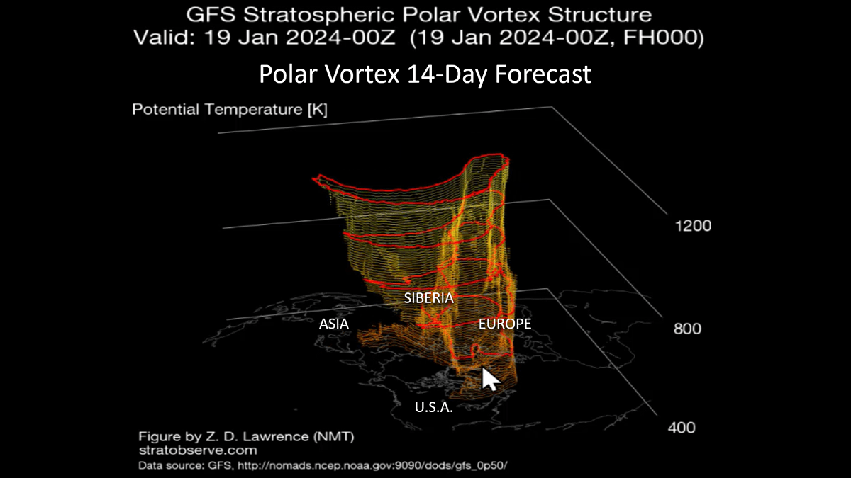
According to the sun we're 33% through Winter, according to meteorologists we're 55%. Either way the Polar Vortex is finally lifting out with a big January Thaw on the way. CLICK ON IMAGES FOR A LARGER VIEW.
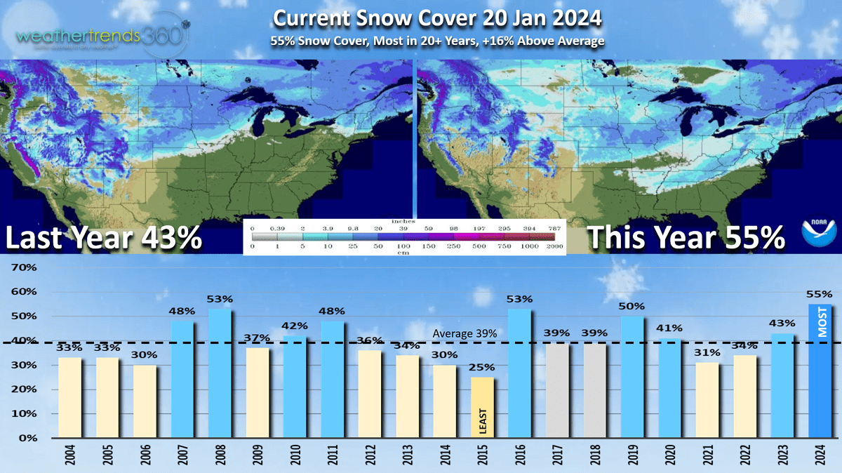
For now, the East is still in the grips of the Polar Vortex which ended the 2-year snow drought for the DC to NYC corridor. This morning 55% of the country had snow on the ground which is the most for this date in over 20 years. The big change is dramatically less snow in the Sierras compared to this time last year. They'll make up so ground next week.
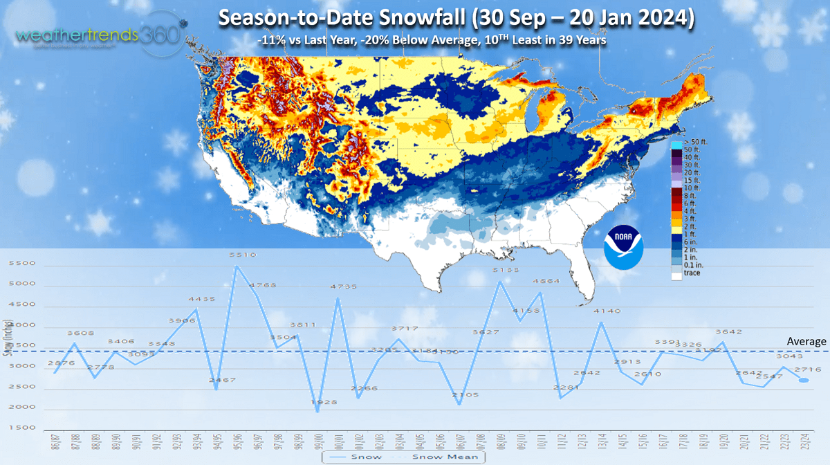
Season-to-date National snowfall has also made up some ground with snowfall now only -11% vs last year, -20% below average and 10th least in 39 years. We were #1 least back in December. This will make more improvement with a much snowier February.
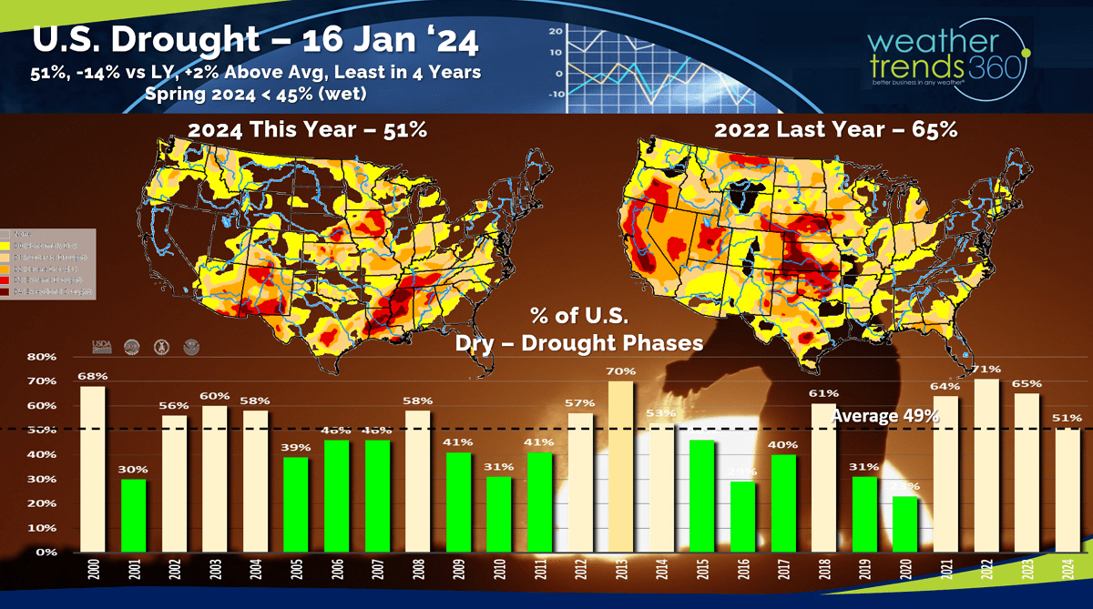
With the stormy El Niño pattern, drought has also made significant improvements with 51% of the U.S. in dry to drought phases vs 65% last year. This is the least drought coverage in 4 years. Typical for this time of year would be around 49%. This will continue to improve over the next couple of months.

Flu has clearly peaked back in late December and continues to trend down for the 2nd week in a row. This season peaked 5-weeks later than last year's near record early Thanksgiving peak and about 10% less severe than last year.
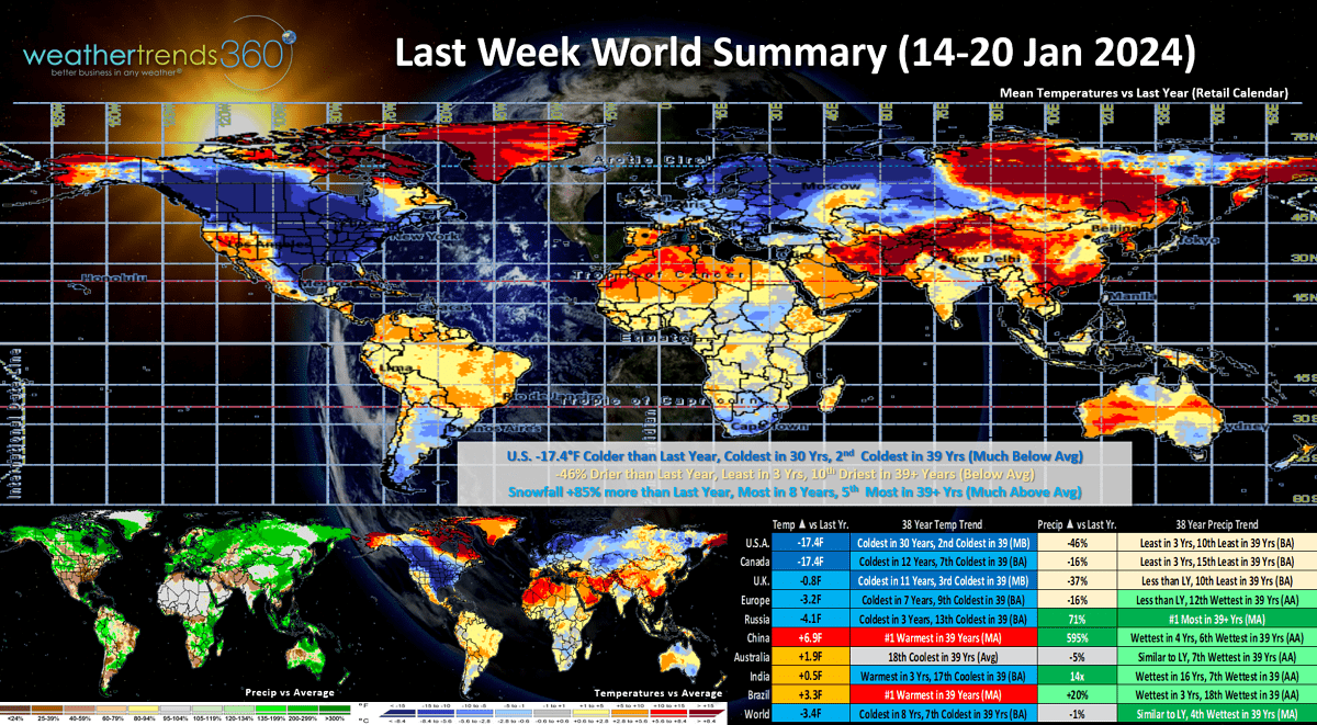
Last Week (14-20 Jan) across the World shows the U.S. in the grips of the Polar Vortex trending a very significant -17.4F colder than last year, coldest in 30 years and 2nd coldest in 39 with much below average temperatures. This was exceptional for auto battery failures - even the EVs couldn't handle the sub-zero temps in the Midwest.
NOTE: wt360 has some neat widgets to help EV owners better anticipate just how much drain they'll have on battery performance: EV WIDGET CALCULATOR
Any Winter or snow related merchandise certainly had exceptional sales gains over last year. Snowfall was up +85% over LY, most in 8 years and 5th most in 39 years, while rainfall was -46% drier than a year ago, least in 3 years and 10th least of the past 39 years. Canada was the coldest in 12 years, the U.K. the coldest in 11 years and Europe the coldest in 7 years benefiting multi-national suppliers and retailers of seasonal merchandise.
Now the Polar Vortex looks to get stronger again which will pull out all the frigid Arctic air back to the North Pole over the next couple weeks. It does appear to get weaker again in early February which will allow for another invasion in the U.S. wt360 is projecting February to be the coldest and snowiest in 3 years for the U.S. overall, particularly in the East.
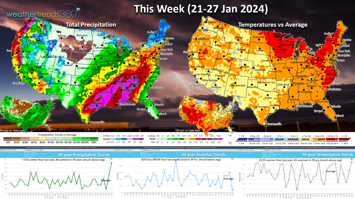
This week (21-27 Jan) shows a big January Thaw across the entire U.S. with national temperatures trending +5.3F warmer than last year making it the #1 warmest in 39+ years. Snowfall down -82% vs LY and also #1 least in 39 years while rainfall is excessive trending +72% wetter than a year ago and #1 wettest. Flooding is going to be a MAJOR CONCERN in the South and especially the Middle Atlantic - Northeast in the months ahead. The snowy spots this week will be the Sierras of California - they need it!
Another wt360 ENERGY WIDGET shows how your energy consumption will trend in the year-ahead.
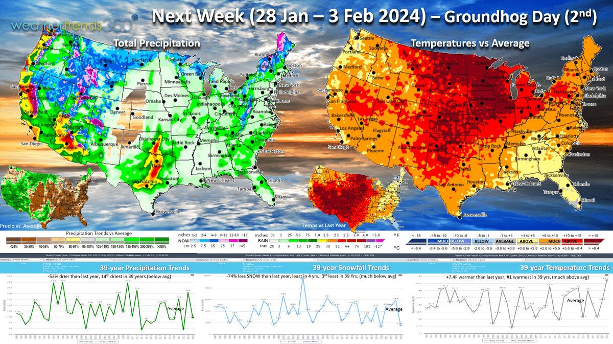
Next week (28 Jan - 3 Feb) shows a typical weather pattern when the Polar Vortex lifts out with a rapid warm up. Nationally temperatures trend +7.4F warmer than a year ago and #1 warmest of the past 39. Snowfall again -74% less than a year ago, least in 4 years and 3rd least of the past 39 years, with rainfall -53% drier than a year ago and 14th driest of the past 39 years. Store traffic tends to go up in warmer/drier weather benefiting non seasonal categories. We'll see what the Groundhog has to say about the rest of Winter on 2 February.
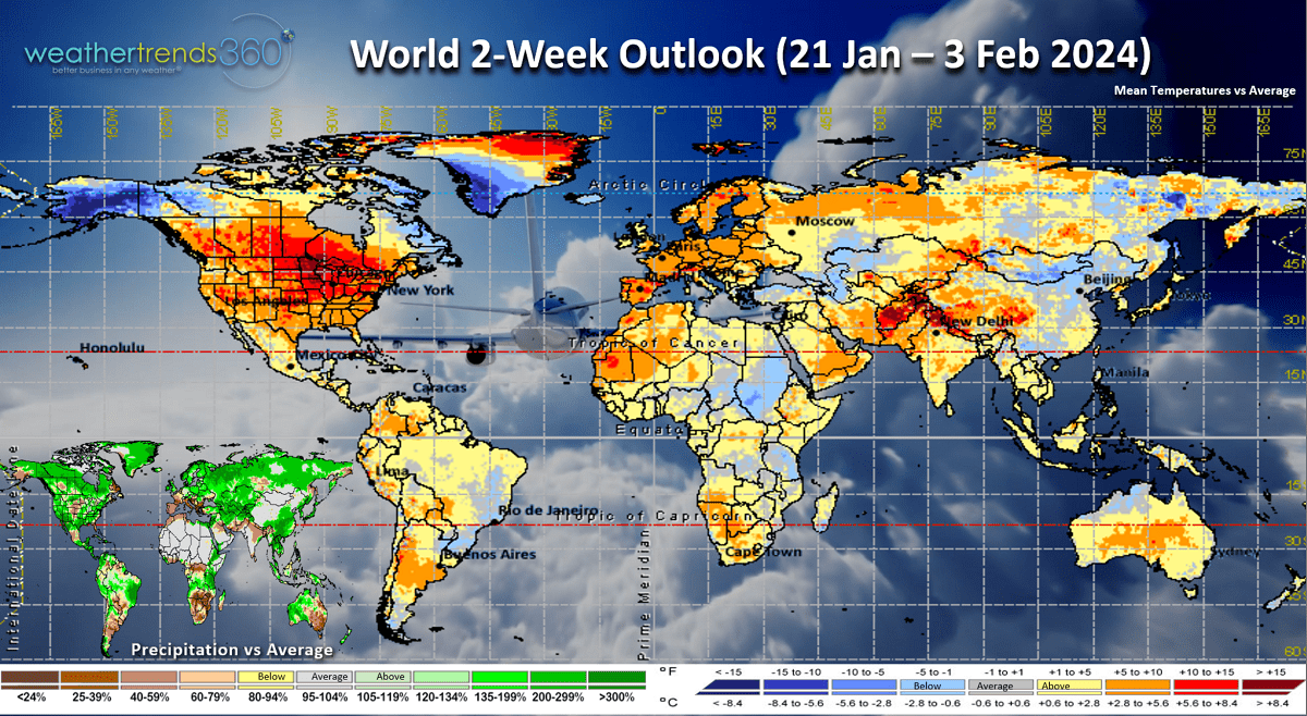
The 2-week World Outlook (21 Jan - 3 Feb) shows the cold air has moved out of much of North America and back to the North Pole and Alaska. It will return in early to middle February.
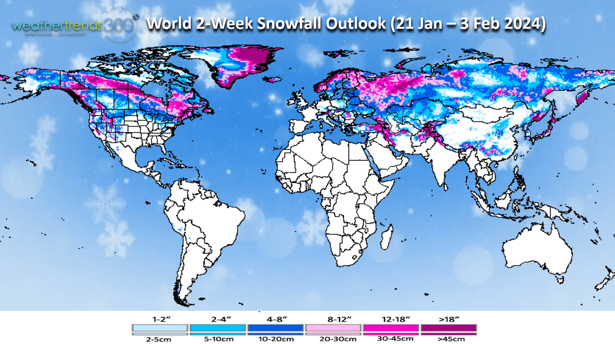
World snowfall shows heavier snow limited to the Western U.S., far northern New England, Eastern Canada and Southwest Russia.
Have a great week ahead, and don't forget to follow us on social media for frequent updates: Facebook, Twitter, YouTube, Pinterest and Linkedin.
- Captain Kirk out