Captain's Log 25 Mar '23: Milder but still Snowy Trends
Captain's Log
25 March '23 Update: Happy Saturday.
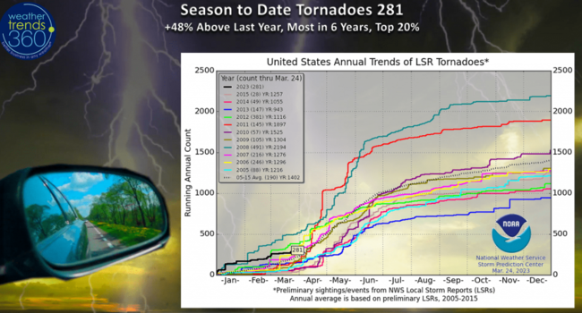
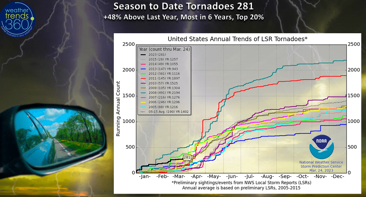
Prayers for the 23 folks killed in last nights tornadic outbreak across Mississippi. Nighttime tornadoes are always so dangerous. The tornado season continues to trend in the top 20% most active, +48% above average and fastest start in 6 years. WTI expects the most active season in 4 years. CLICK ON IMAGES FOR A LARGER VIEW.
With the collapse of the 3-year La Nina cycle, rainfall is up and that means drought is steadily diminishing. 52% of the U.S. in dry to drought phases but that's way down from the early November peak of 82%. This trend will continue into a wet phase for 2023 and 2024.
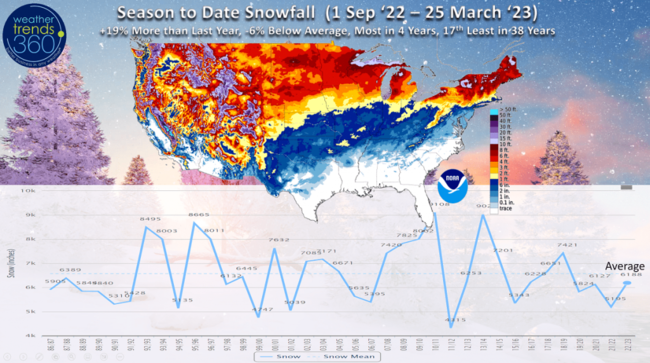
Season to date snowfall (1 Sep - 25 Mar) is now the most in 4 years nationally trending +19% more than last year but still -6% below average and 17th least of the past 38 years. Heavy snowfall this March has boosted the seasonal totals.
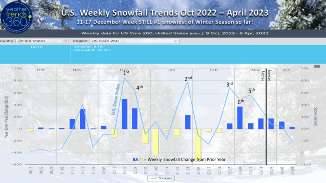
The middle December is likely to remain the snowiest week of the entire season, a tad unusual. The season is ending with 7 straight snowier weeks than last year, even into early April.
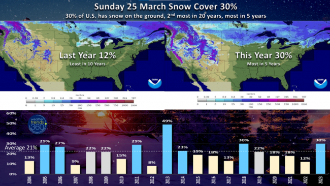
This has snow cover today the 2nd most in 20 years with 30% of the country with snow on the ground, most in 5 years. Last year only 12% had snow on the ground and the least in 10 years. Average snow cover this time of year is 21%.
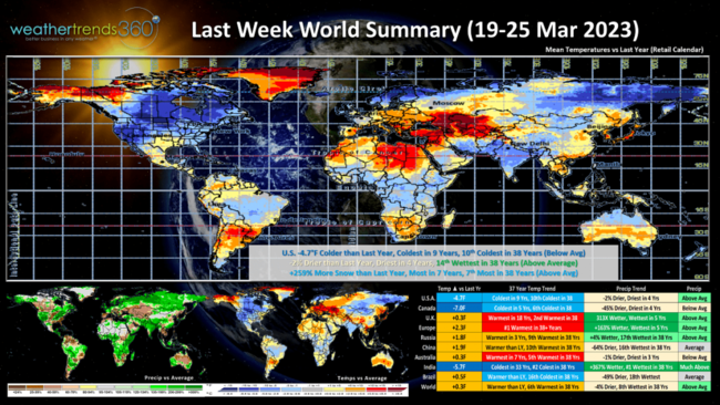
Last Week (19-25 March) across the World shows the U.S. trending -4.7F colder than last year, coldest in 9 years and 10th coldest in 38 years with below average national temperatures. Widespread severe freezes plunged all the way to the Gulf Coast and North Florida over the St. Patrick's Day weekend. Rainfall was -2% less than a year ago, driest in 4 years but still 14th wettest of the past 38 years. Snowfall was +259% more than last year, most in 7 years and 7th most in 38 years. These are very unfavorable trends for retail spring seasonal category sales.

The 6-day snowfall forecast (25-30 March) continues to show a snowy pattern with +225% more snow than last year, most in 5 years, +141% above average and 3rd most in 38 years. 49% of the country has some risk for snow this week. A big negative trend for Spring sales.
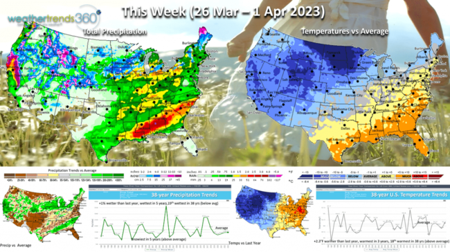
This week (26 Mar - 1 Apr) shows a milder pattern with the U.S. trending +2.3F warmer than last year, warmest in 3 years and 18th warmest of the past 38 years with slightly above average national temperatures. Rainfall just +1% above last year, most in 5 years and 19th wettest of the past 38 years with slightly below average rainfall. Snowfall is the most in 5 years and above average for a snowy end to March. The warmer and drier areas like Florida, Texas and the Middle Atlantic will have higher suffering of allergy and asthma. More severe weather possible in the Southeast.

Next week (2-8 April) shows more severe weather likely from Texas to Tennessee with the battle ground between cold for the Northwest half of the U.S. and warm Southeast. National temperatures +0.6F warmer than last year but still 18th coldest of the past 38 years with slightly below average national temperatures. Rainfall -43% drier than last year, driest in 3 years but that's 11th driest of the past 38 years. A tad misleading as storminess is fairly wide spread. Snowfall the most in 4 years and near average nationally.
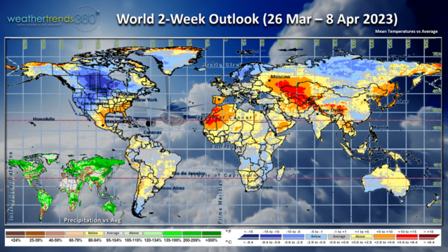
The World 2-week outlook (26 Mar - 8 Apr) shows Europe cooling off a bit from the record warmth last week while the Southeast remains the warm spot in the U.S. Canada remains cold and unfavorable for Spring merchandise sales.
Have a great last week of March and don't forget to follow us on social media for frequent updates: Facebook, Twitter, YouTube, Pinterest and Linkedin.
- Captain Kirk out.
Prayers for the 23 folks killed in last nights tornadic outbreak across Mississippi. Nighttime tornadoes are always so dangerous. The tornado season continues to trend in the top 20% most active, +48% above average and fastest start in 6 years. WTI expects the most active season in 4 years. CLICK ON IMAGES FOR A LARGER VIEW.
With the collapse of the 3-year La Nina cycle, rainfall is up and that means drought is steadily diminishing. 52% of the U.S. in dry to drought phases but that's way down from the early November peak of 82%. This trend will continue into a wet phase for 2023 and 2024.

Season to date snowfall (1 Sep - 25 Mar) is now the most in 4 years nationally trending +19% more than last year but still -6% below average and 17th least of the past 38 years. Heavy snowfall this March has boosted the seasonal totals.

The middle December is likely to remain the snowiest week of the entire season, a tad unusual. The season is ending with 7 straight snowier weeks than last year, even into early April.
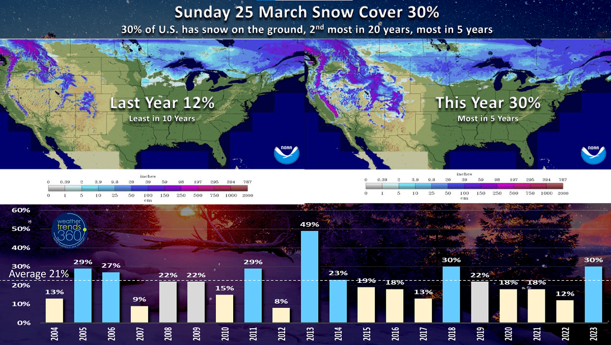
This has snow cover today the 2nd most in 20 years with 30% of the country with snow on the ground, most in 5 years. Last year only 12% had snow on the ground and the least in 10 years. Average snow cover this time of year is 21%.
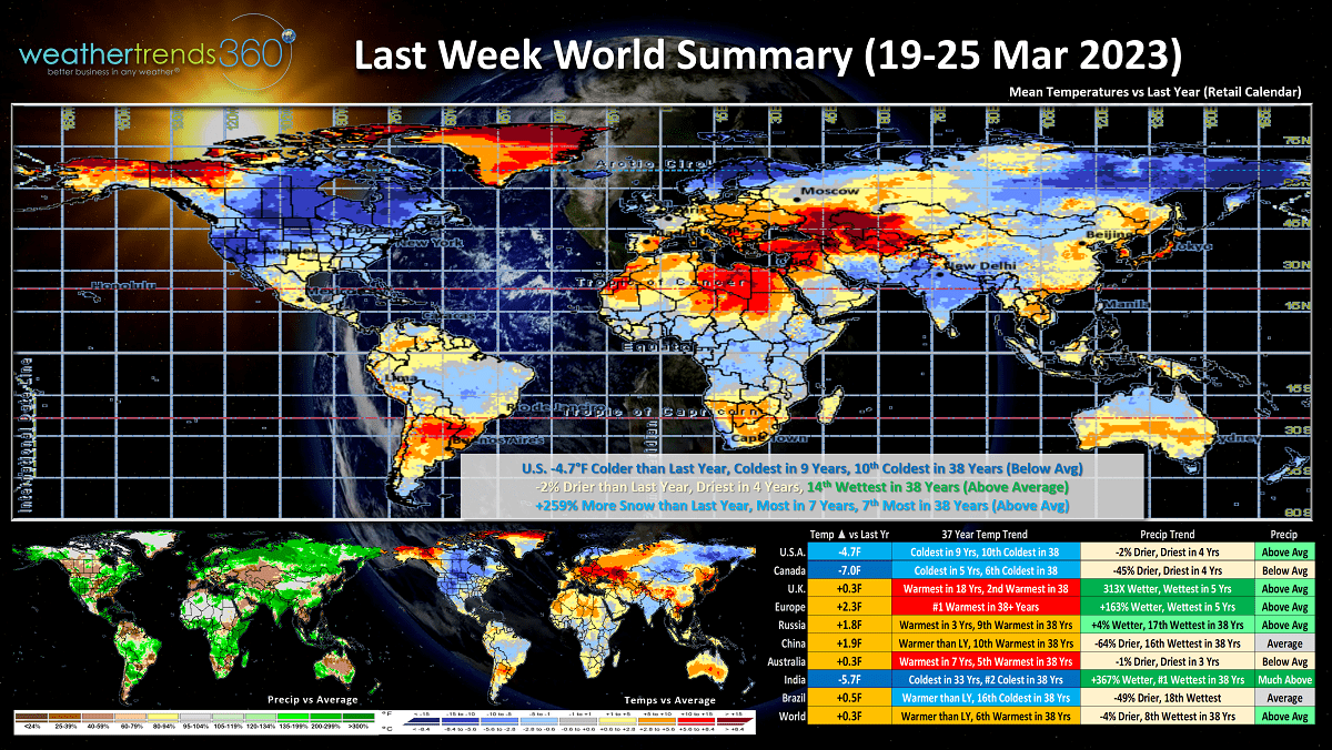
Last Week (19-25 March) across the World shows the U.S. trending -4.7F colder than last year, coldest in 9 years and 10th coldest in 38 years with below average national temperatures. Widespread severe freezes plunged all the way to the Gulf Coast and North Florida over the St. Patrick's Day weekend. Rainfall was -2% less than a year ago, driest in 4 years but still 14th wettest of the past 38 years. Snowfall was +259% more than last year, most in 7 years and 7th most in 38 years. These are very unfavorable trends for retail spring seasonal category sales.
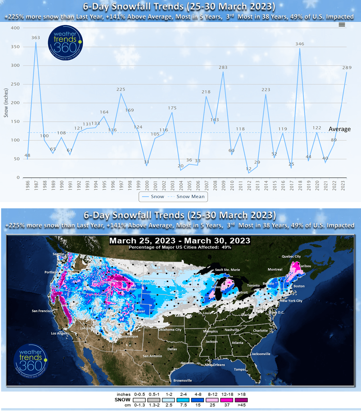
The 6-day snowfall forecast (25-30 March) continues to show a snowy pattern with +225% more snow than last year, most in 5 years, +141% above average and 3rd most in 38 years. 49% of the country has some risk for snow this week. A big negative trend for Spring sales.
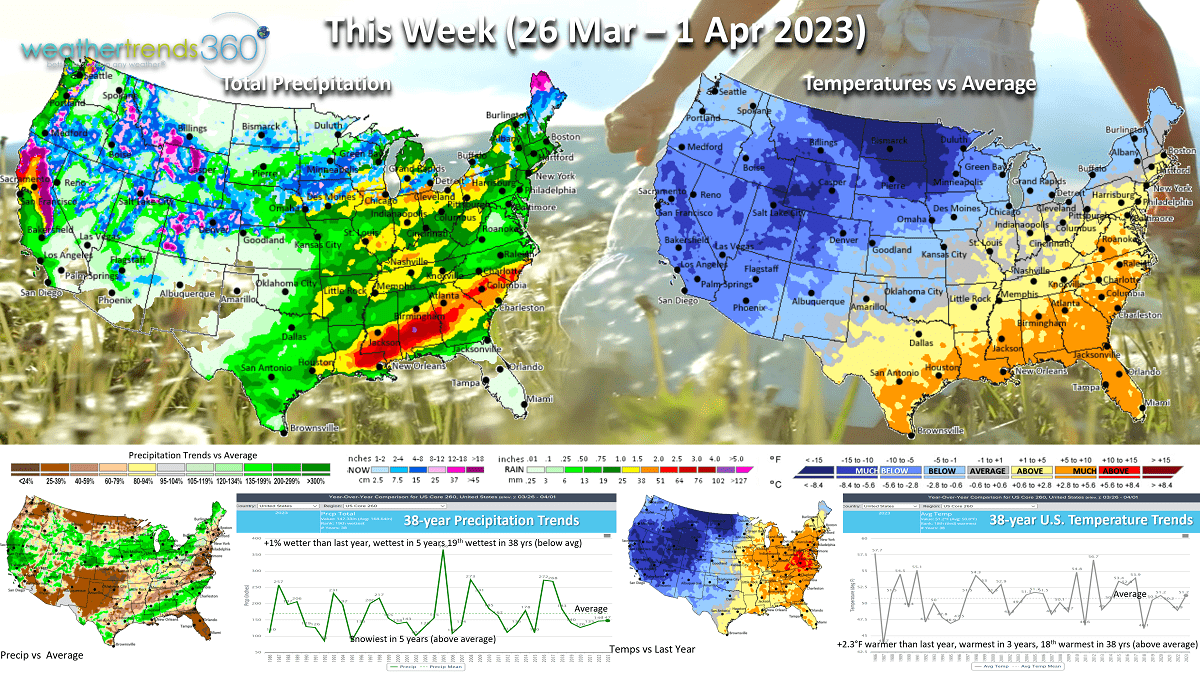
This week (26 Mar - 1 Apr) shows a milder pattern with the U.S. trending +2.3F warmer than last year, warmest in 3 years and 18th warmest of the past 38 years with slightly above average national temperatures. Rainfall just +1% above last year, most in 5 years and 19th wettest of the past 38 years with slightly below average rainfall. Snowfall is the most in 5 years and above average for a snowy end to March. The warmer and drier areas like Florida, Texas and the Middle Atlantic will have higher suffering of allergy and asthma. More severe weather possible in the Southeast.
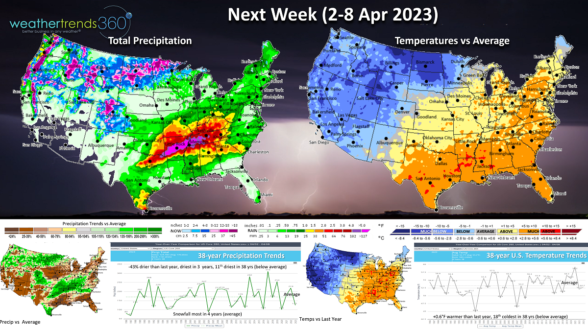
Next week (2-8 April) shows more severe weather likely from Texas to Tennessee with the battle ground between cold for the Northwest half of the U.S. and warm Southeast. National temperatures +0.6F warmer than last year but still 18th coldest of the past 38 years with slightly below average national temperatures. Rainfall -43% drier than last year, driest in 3 years but that's 11th driest of the past 38 years. A tad misleading as storminess is fairly wide spread. Snowfall the most in 4 years and near average nationally.

The World 2-week outlook (26 Mar - 8 Apr) shows Europe cooling off a bit from the record warmth last week while the Southeast remains the warm spot in the U.S. Canada remains cold and unfavorable for Spring merchandise sales.
Have a great last week of March and don't forget to follow us on social media for frequent updates: Facebook, Twitter, YouTube, Pinterest and Linkedin.
- Captain Kirk out.