Captain's Log 25 May '24 Severe Weather Off the Scale
Captain's Log
25 May '24: Happy Saturday! :)
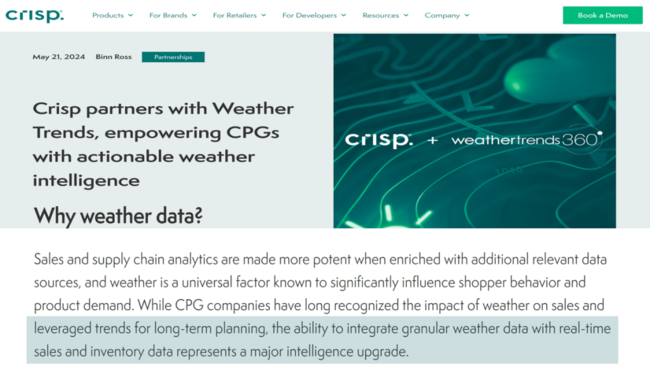
Weather Trends International has partnered with Crisp to help retailers and CPG companies better plan both long term (year ahead) and near term with real-time sales and inventory data intelligence. CLICK ON IMAGES FOR A LARGER VIEW.
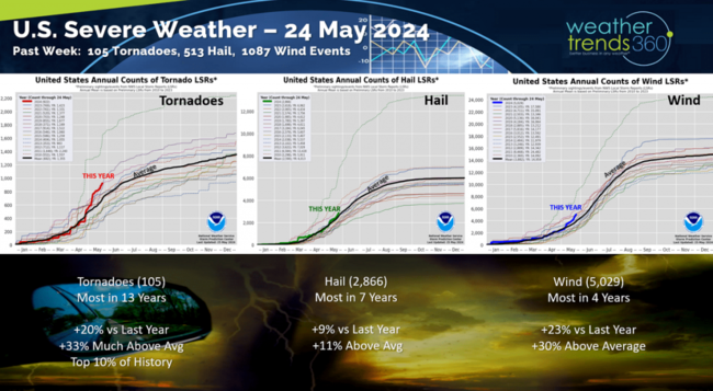
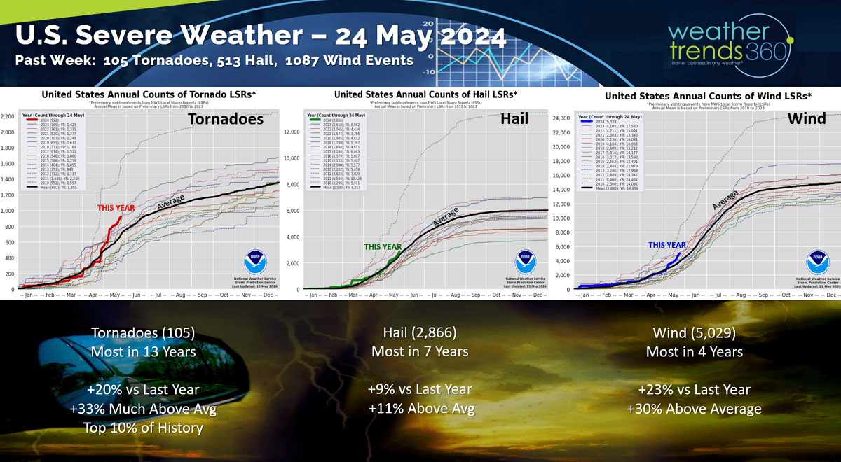
The timing couldn't be more perfect with almost all retailers reporting negative SSS trends this past quarter with many blaming the wet weather as a major headwind. Unfortunately, those head-winds will increase in part due to a continued severe weather cycle. This past week there were 105 tornadoes, 513 hail events and a whopping 1,087 wind events. The severe weather season is now the most active in 13 years for tornadoes, most in 7 years for hail and most in 4 for wind events.
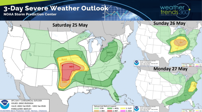
Another major severe weather outbreak this Memorial Day weekend from the Central U.S. to the East Coast.
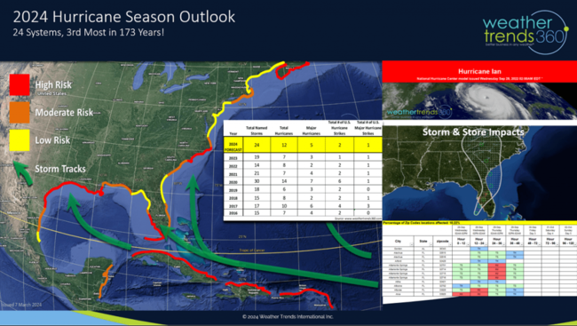
Sadly the 2024 hurricane season looks to be equally devastating as even NOAA officially came out with their biggest tally of predicted storms/hurricanes in history.

WTI warned of this a year ago as the climate cycles are perfectly aligned for a hyper-active season. WTI's long range hurricane forecast was the first to warn of 24+ named storms/hurricanes, the 3rd most in 173 years of records.
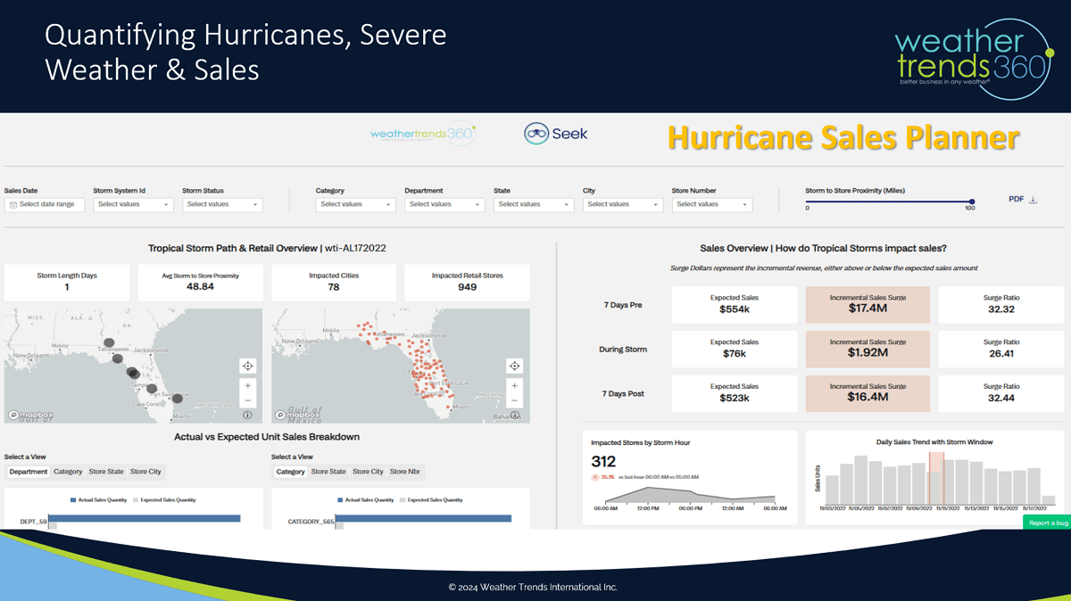
If you haven't seen our severe weather and hurricane sales planner apps, please contact us at https://www.weathertrends360.com/Contact for more information on PROACTIVE sales/inventory planning around these catastrophic events.

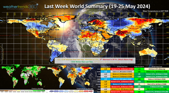
Last week (19-25 May) across the World shows the U.S. trending +2.4F warmer than last year, warmest in 3 years and 3rd warmest in 39 years. Rainfall continued to trend up +31% vs last year but finally below average and 15th driest in 39 years nationally. This was a more favorable week for retail seasonal merchandise sales. Canada was cooler and much wetter helping to reduce the fire threat. Last year at this point in the year was near record dry, this year near average YTD and well above average the past couple months.
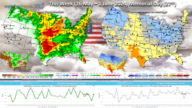
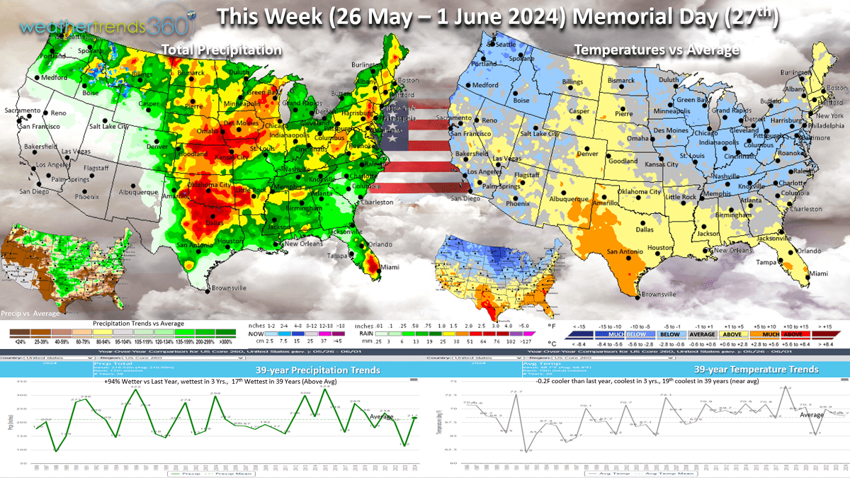
This week (26 May - 1 June) across the U.S. shows the cold weather responsible for the severe weather as it clashes with warm air to the South and East. This cooler weather will advance East this week and gradually bring a temporary reprieve from all the severe weather. The U.S. overall trends -0.2F cooler than last year, coolest in 3 years and 19th coolest of the past 39 years. Rainfall continues to trend up +94% vs last year, most in 3 years and 17th wettest of the past 39 years. Excessive rain continues from TX to WI. This is a generally unfavorable week for spring seasonal sales compared to last year which was very dry benefiting outdoor activities and store traffic.
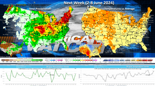
Next week (2-8 June) is the official start to the 2024 hurricane season. The U.S. overall trends +2.9F warmer than last year, warmest in 3 years and 2nd warmest of the past 39 years. This will likely help some hot weather categories, but rainfall continues to be up +118% over last year, most in 5 years and 13th most in 39 years. Excessive rainfall possible from KS to New England.
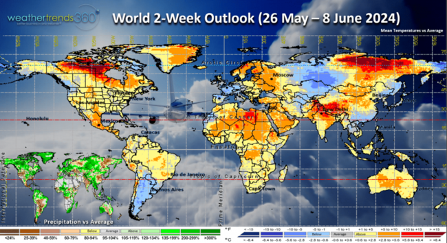
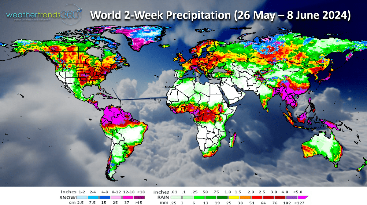
The World 2-week outlook (26 May - 8 June) shows a warming trend for Canada, cooling for Western Europe and more heavy rain across the Eastern half of the U.S., much of Canada and Europe.

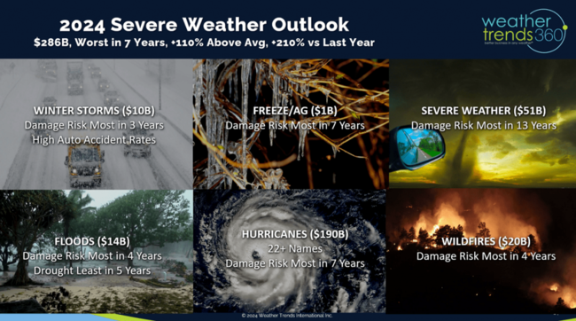
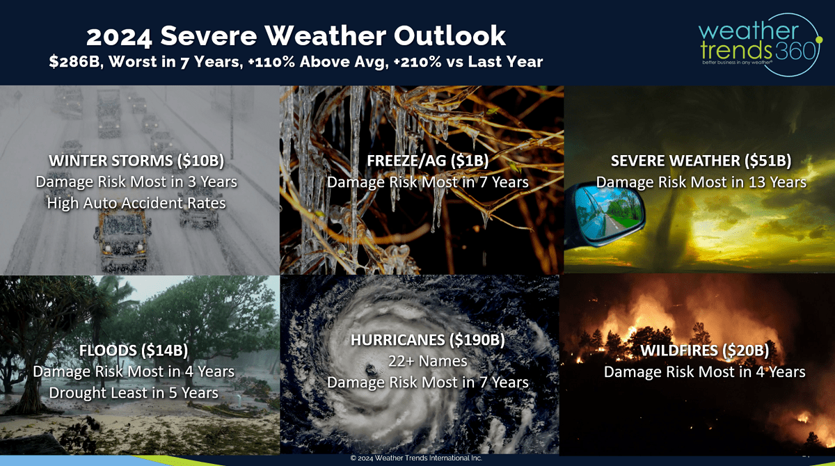
We end today's video with a reminder that WTI predicted all this severe weather last Fall and sadly it's happening. (Insurance VIDEO) It's about to get a lot worse with the hurricane season in the months ahead making U.S. billion-dollar damage toping $286B, +210% over last year and the most in 7 years!
Have a great Memorial Day weekend and week ahead. Don't forget to follow us on social media for frequent updates:
Twitter, YouTube, Pinterest and Linkedin.
Captain Kirk out.
Weather Trends International has partnered with Crisp to help retailers and CPG companies better plan both long term (year ahead) and near term with real-time sales and inventory data intelligence. CLICK ON IMAGES FOR A LARGER VIEW.

The timing couldn't be more perfect with almost all retailers reporting negative SSS trends this past quarter with many blaming the wet weather as a major headwind. Unfortunately, those head-winds will increase in part due to a continued severe weather cycle. This past week there were 105 tornadoes, 513 hail events and a whopping 1,087 wind events. The severe weather season is now the most active in 13 years for tornadoes, most in 7 years for hail and most in 4 for wind events.
Another major severe weather outbreak this Memorial Day weekend from the Central U.S. to the East Coast.

Sadly the 2024 hurricane season looks to be equally devastating as even NOAA officially came out with their biggest tally of predicted storms/hurricanes in history.
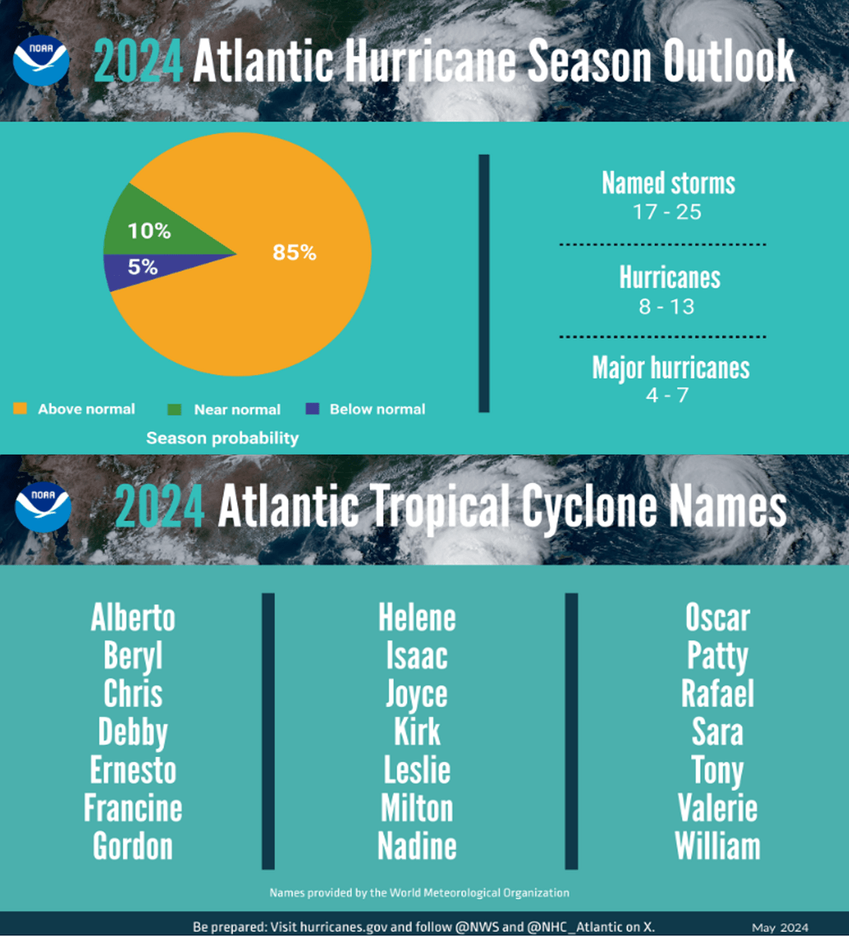
WTI warned of this a year ago as the climate cycles are perfectly aligned for a hyper-active season. WTI's long range hurricane forecast was the first to warn of 24+ named storms/hurricanes, the 3rd most in 173 years of records.

If you haven't seen our severe weather and hurricane sales planner apps, please contact us at https://www.weathertrends360.com/Contact for more information on PROACTIVE sales/inventory planning around these catastrophic events.
Last week (19-25 May) across the World shows the U.S. trending +2.4F warmer than last year, warmest in 3 years and 3rd warmest in 39 years. Rainfall continued to trend up +31% vs last year but finally below average and 15th driest in 39 years nationally. This was a more favorable week for retail seasonal merchandise sales. Canada was cooler and much wetter helping to reduce the fire threat. Last year at this point in the year was near record dry, this year near average YTD and well above average the past couple months.

This week (26 May - 1 June) across the U.S. shows the cold weather responsible for the severe weather as it clashes with warm air to the South and East. This cooler weather will advance East this week and gradually bring a temporary reprieve from all the severe weather. The U.S. overall trends -0.2F cooler than last year, coolest in 3 years and 19th coolest of the past 39 years. Rainfall continues to trend up +94% vs last year, most in 3 years and 17th wettest of the past 39 years. Excessive rain continues from TX to WI. This is a generally unfavorable week for spring seasonal sales compared to last year which was very dry benefiting outdoor activities and store traffic.
Next week (2-8 June) is the official start to the 2024 hurricane season. The U.S. overall trends +2.9F warmer than last year, warmest in 3 years and 2nd warmest of the past 39 years. This will likely help some hot weather categories, but rainfall continues to be up +118% over last year, most in 5 years and 13th most in 39 years. Excessive rainfall possible from KS to New England.

The World 2-week outlook (26 May - 8 June) shows a warming trend for Canada, cooling for Western Europe and more heavy rain across the Eastern half of the U.S., much of Canada and Europe.

We end today's video with a reminder that WTI predicted all this severe weather last Fall and sadly it's happening. (Insurance VIDEO) It's about to get a lot worse with the hurricane season in the months ahead making U.S. billion-dollar damage toping $286B, +210% over last year and the most in 7 years!
Have a great Memorial Day weekend and week ahead. Don't forget to follow us on social media for frequent updates:
Twitter, YouTube, Pinterest and Linkedin.
Captain Kirk out.