Captain's Log 26 Aug '23 Out of Sync Weather - Florida Storm
Captain's Log
26 Aug 2023: Happy Saturday! :)
Florida is likely to get hit by a Tropical Storm or Hurricane mid-week! Almost a certainty that we'll have Idalia (#10th storm of the season) developing in the Caribbean and heading north toward northern Florida. CLICK ON IMAGES FOR A LARGER VIEW.

For now, models show a CAT 1 hurricane is the strongest Idalia would become, but the system will traverse over 88F to 90F waters in the Eastern Gulf which can lead to explosive intensification, something to watch!
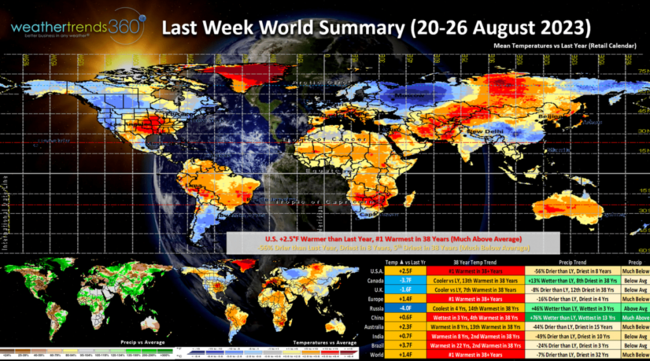
Last week (20-26 Aug) around the World shows the U.S. trending +2.5F warmer than last year and #1 hottest in over 38 years nationally. Rainfall was down -56% vs last year, least in 8 years and 5th least in 38 years with much below average rainfall. This despite the flooding rains on the West Coast with the remnants of Tropical Storm Hillary and Tropical Storm Harold in South Texas. With the emerging strong to extreme El Niño, it's not surprising that the World is heating up with Europe the #1 hottest in over 38 years, India and Brazil 2nd hottest and China 4th hottest.
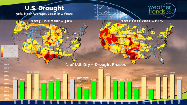
Dry to Drought phases across the U.S. stand at 50% of the country which is exactly average for this time of year. Dry conditions nationally are the least in 4 years with the most extreme drought in the Southwest Gulf of Mexico and parts of the Heartland.
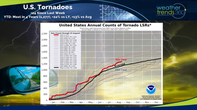
Tornadoes continue to add up with 1,277 to date, up +24 from last week. Season to date is now +22% more than last year, most in 4 years and +13% above average.
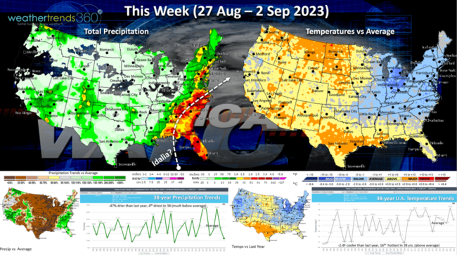
This week (27 Aug - 2 Sep) shows the conveyor belt of tropical moisture from Florida into the Middle Atlantic. What should become Idalia needs to be watched as the risk for rapid intensification and flooding rains is likely. The Northeast and Midwest will have below average temperatures, a plus for back2school sales, but the heat is already building again in the Plains and South which will expand into September. The U.S. overall trends -2.4F cooler than last year, 16th warmest of the past 38 years with rainfall down -47% vs last year and 4th driest of the past 38 years.

Next week (3-9 Sep) shows the building heat across much of the U.S., even the Northeast. The heart of the heat will be in the Central U.S. while the West Coast cools off. The U.S. overall looks to trend +2.1F warmer than last year and #1 warmest in 38 years. Rainfall -65% less than a year ago, driest in 18 years and 2nd driest in 38 years. These are very negative trends for back2school and early Fall seasonal categories. This time of year colder and wetter conditions benefit overall retail sales. This is a continuation of an out of sync weather year for retailers.
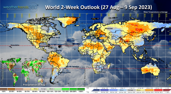
The World outlook (27 Aug - 9 Sep) shows warm conditions around the World with the few cooler spots in Argentina, Southeast China and Central Alaska. These trends benefit Summer consumable categories at the expense of early Fall seasonal merchandise.
Have a great week ahead and don't forget to follow us on social media for frequent updates: Facebook, Twitter, YouTube, Pinterest and Linkedin.
- Captain Kirk out
Florida is likely to get hit by a Tropical Storm or Hurricane mid-week! Almost a certainty that we'll have Idalia (#10th storm of the season) developing in the Caribbean and heading north toward northern Florida. CLICK ON IMAGES FOR A LARGER VIEW.
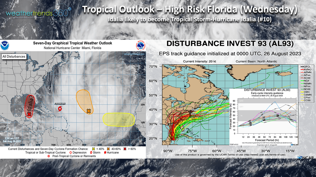
For now, models show a CAT 1 hurricane is the strongest Idalia would become, but the system will traverse over 88F to 90F waters in the Eastern Gulf which can lead to explosive intensification, something to watch!
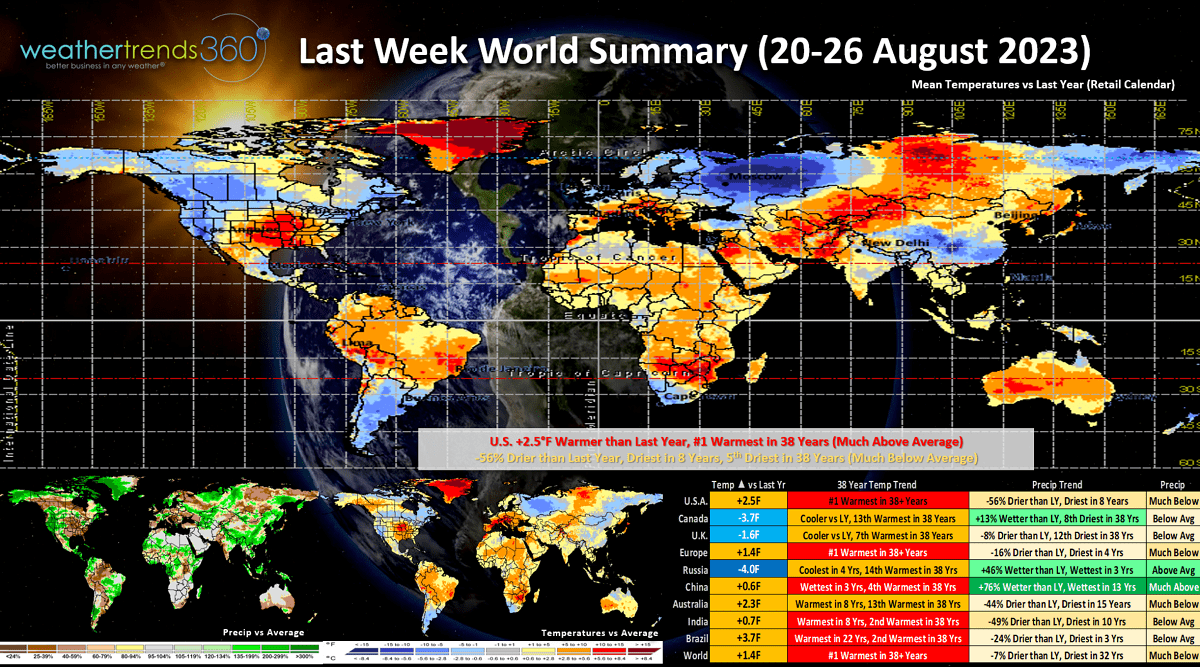
Last week (20-26 Aug) around the World shows the U.S. trending +2.5F warmer than last year and #1 hottest in over 38 years nationally. Rainfall was down -56% vs last year, least in 8 years and 5th least in 38 years with much below average rainfall. This despite the flooding rains on the West Coast with the remnants of Tropical Storm Hillary and Tropical Storm Harold in South Texas. With the emerging strong to extreme El Niño, it's not surprising that the World is heating up with Europe the #1 hottest in over 38 years, India and Brazil 2nd hottest and China 4th hottest.

Dry to Drought phases across the U.S. stand at 50% of the country which is exactly average for this time of year. Dry conditions nationally are the least in 4 years with the most extreme drought in the Southwest Gulf of Mexico and parts of the Heartland.
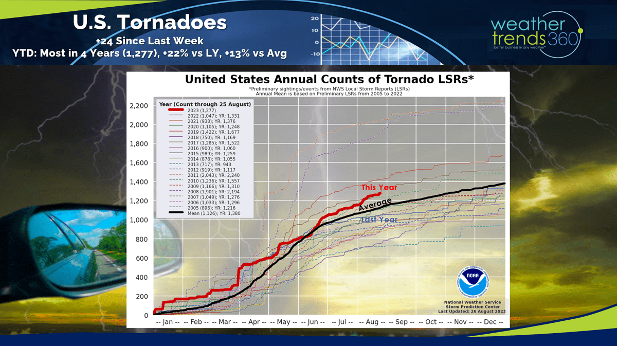
Tornadoes continue to add up with 1,277 to date, up +24 from last week. Season to date is now +22% more than last year, most in 4 years and +13% above average.
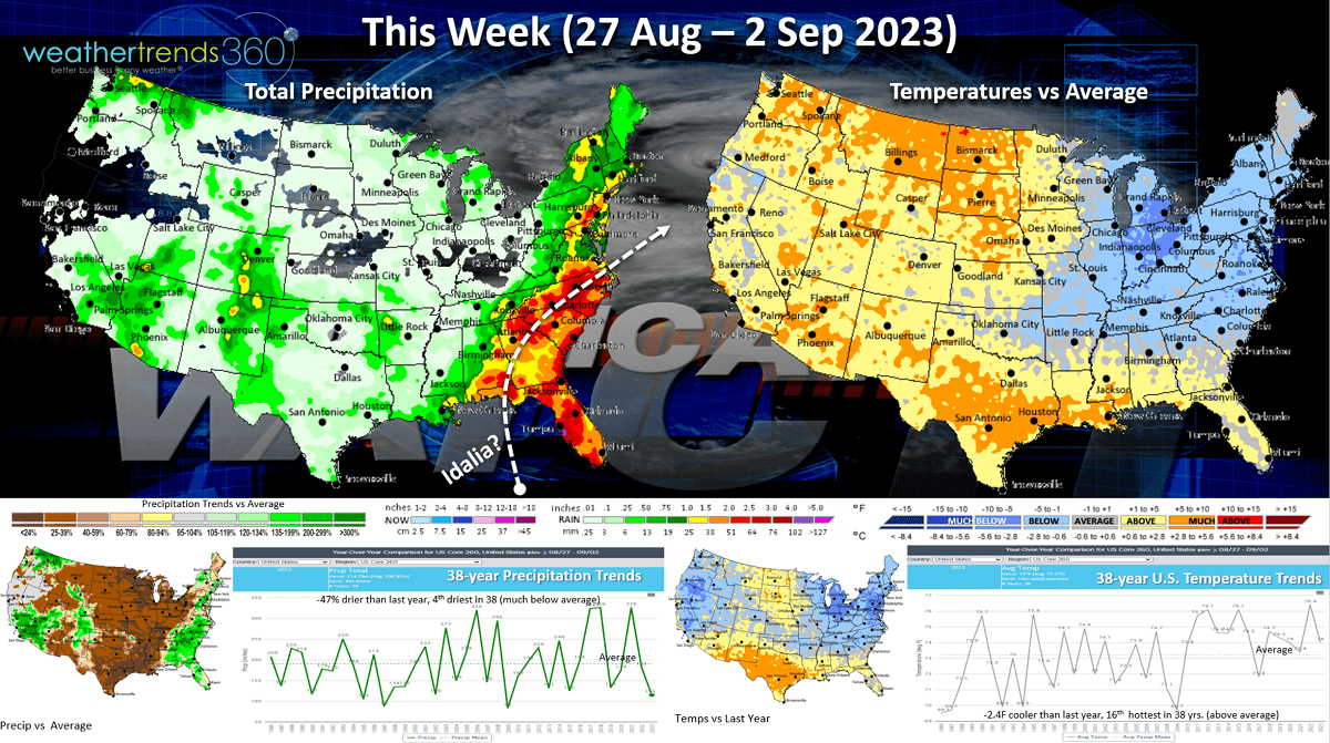
This week (27 Aug - 2 Sep) shows the conveyor belt of tropical moisture from Florida into the Middle Atlantic. What should become Idalia needs to be watched as the risk for rapid intensification and flooding rains is likely. The Northeast and Midwest will have below average temperatures, a plus for back2school sales, but the heat is already building again in the Plains and South which will expand into September. The U.S. overall trends -2.4F cooler than last year, 16th warmest of the past 38 years with rainfall down -47% vs last year and 4th driest of the past 38 years.
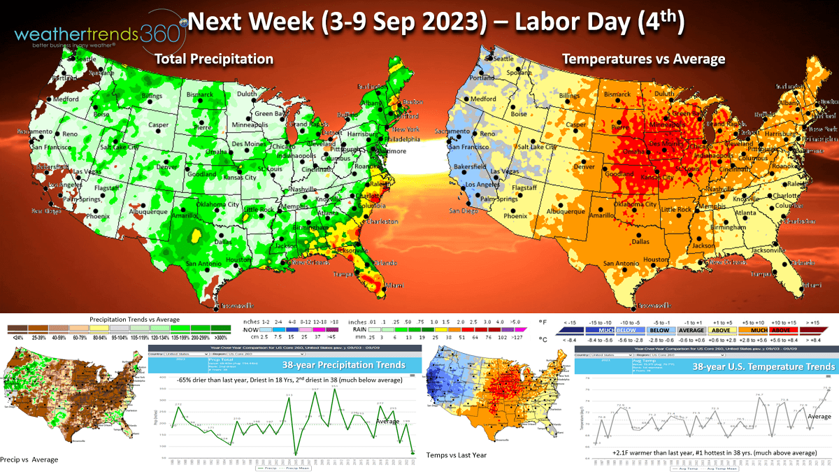
Next week (3-9 Sep) shows the building heat across much of the U.S., even the Northeast. The heart of the heat will be in the Central U.S. while the West Coast cools off. The U.S. overall looks to trend +2.1F warmer than last year and #1 warmest in 38 years. Rainfall -65% less than a year ago, driest in 18 years and 2nd driest in 38 years. These are very negative trends for back2school and early Fall seasonal categories. This time of year colder and wetter conditions benefit overall retail sales. This is a continuation of an out of sync weather year for retailers.

The World outlook (27 Aug - 9 Sep) shows warm conditions around the World with the few cooler spots in Argentina, Southeast China and Central Alaska. These trends benefit Summer consumable categories at the expense of early Fall seasonal merchandise.
Have a great week ahead and don't forget to follow us on social media for frequent updates: Facebook, Twitter, YouTube, Pinterest and Linkedin.
- Captain Kirk out