Captain's Log 27 July '21 Hot In the Central U.S.; Cold Brazil
Counting down the days now until we're in our new home in downtown Bethlehem, PA! Hard to believe that we're just a few short days away from August! This week's Captain Log takes a look at the big weather stories last week and a look ahead. Lots to talk about so let's get to it! CLICK ON IMAGES FOR A LARGER VIEW.
Last Week (18-24 July): Cold and dry conditions continue to plague Brazil where there is real concern about several crops. Last week's spell of cold weather included frosts in Brazil's main coffee belt which has caused a surge in coffee prices. CONAB, the Brazilian government food supply and statistics agency, estimates that nearly 11% of the country's total arabica crop areas were affected by the cold weather. Coffee trees are extremely sensitive and can even die from frosts.
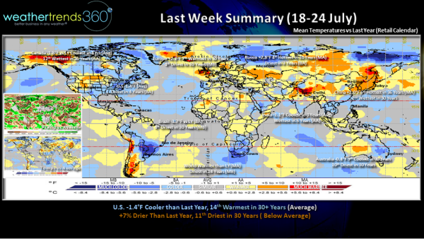
Temperature trends evened out across North America resulting in near average temperatures for both the U.S. and Canada as a whole. However, there were pockets of heat in both countries including the southern Prairies in Canada and the Northern Rocky Mountains and Northern Plains of the U.S. This was balanced by coolness in the eastern portions of these countries.
Wet in China where Typhoon In-fa made landfall on Sunday, the 25th of July in eastern China. In-fa unfortunately struck on the heels of record, deadly flooding. The week-ending July 24th was the 2nd wettest in 30+ years.
In Japan, where the 2020 Olympic games kicked off over this past weekend, the week-ending July 24th trended the 4th hottest in 30+ years and the driest in 3 years.
La Niña Watch: Although we recently transitioned to El Niño Southern Oscillation neutral conditions, the Climate Prediction Center has issued a La Niña Watch as conditions are favorable for La Niña to return within the next 6 months. Indeed, we are starting to see cooler waters build up just beneath the surface in the equatorial Pacific ocean. Although likely on the weaker side, a La Niña is probable in the upcoming autumn and fades early in the winter. Bad news for the tropics which have been quiet as of late in the Atlantic, but WeatherTrends360 expects activity to pick up in the latter half of August and into September. La Niña events help to suppress shear in the tropical Atlantic making it easier for storms to develop and maintain themselves.
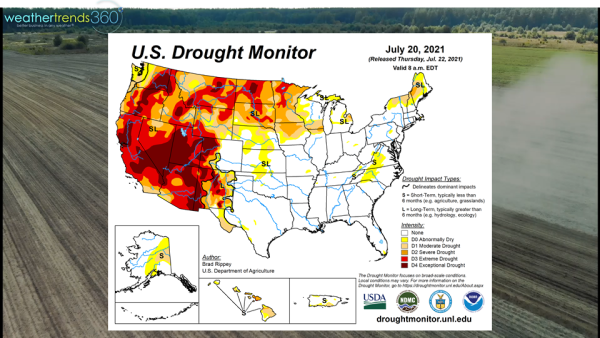
Drought: Unfortunately, a return of La Niña conditions also supports more dryness in many of the areas currently experiencing drought in the U.S. A large portion of the West and northern Plains are experiencing drought conditions as of the latest U.S. Drought Monitor which includes data through July 20th. Meanwhile, areas from Texas to the East Coast are largely drought-free thanks to recent months of wet conditions across this region.
This Week (25-31 July): Hot weather builds this week across the Central U.S. with hot weather from Montana to the South. Air quality will once again be an issue this week as wildfires continue to burn over parts of the Northwest and Northern Rocky Mountains. Largely dry for most of the drought-stricken Northern and High Plains. Hot and dry conditions will further deplete soil moisture across this region.
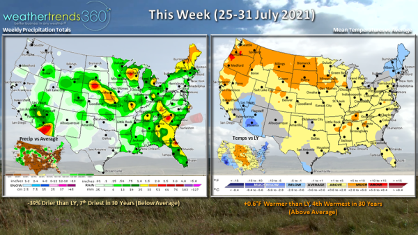
A couple waves of low pressure will move along a frontal boundary bringing the threat of severe thunderstorms to portions of the Great Lakes and into the Northeast. Meanwhile, monsoon showers and thunderstorms will bring rain to the Desert Southwest and this will be the wettest end to July in 4 years for the Southwest region.
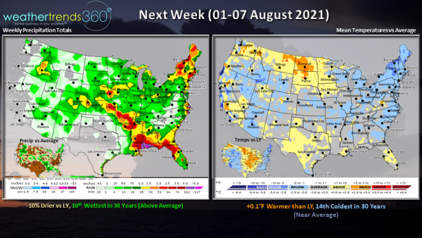
Next Week (01-07 August): Cooler temperatures for this time of year are expected to continue in the Northeast where we'll see the continued threat for showers and thunderstorms. Meanwhile, hotter than normal weather is bottled up across the northern Plains, exactly where they don't need it. Additionally, rainfall is once again looking scarce for the drought-stricken portions of the northern Plains. Monsoon showers and storms will bring some moisture to the Southwest and Southern Rocky Mountains. So far the tropics are looking quiet but we expect activity to pick up in the latter part of August in the Atlantic.
The World 2-week outlook (25 July-07 August): While Typhoon In-fa didn't have major impacts on the Olympic games, Tropical Storm Nepartak is passing close enough to Tokyo this week to bring some gusty winds, thunderstorms, and high waves (a bonus for the surfing competition). Hotter than normal conditions will keep the athletes sweating in Tokyo.
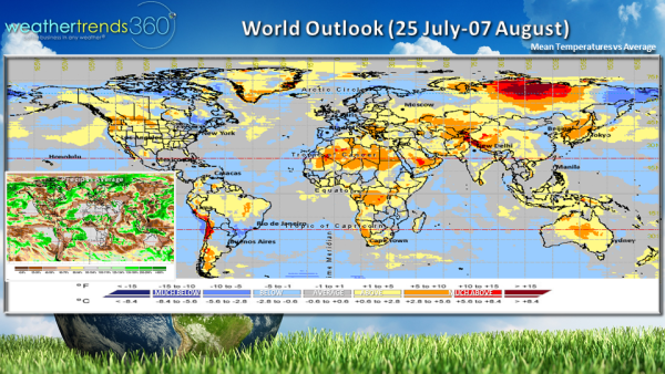
Any tropical activity will be favored in the Western Pacific while the Atlantic should remain fairly quiet through this period.
Cold weather will continue in Brazil with more possible negative impacts for the agricultural sector. Precipitation will also remain below normal as we close out July and head into August.
Don't forget to follow us on social media for frequent updates: Facebook, Twitter, YouTube, Pinterest and LinkedIn.