Captain's Log 6 Jan '24 Huge Gains for Seasonal Items
Captain's Log
6 Jan 2024: Happy Snowy Saturday! :)
The first moderate snow event of the season for us here at wt360 HQ in Bethlehem, PA. wt360 weather Cam South overlooking Bethlehem/Lehigh University shows the snow moving in. CLICK ON IMAGES FOR A LARGER VIEW.
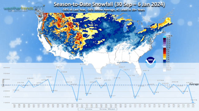
We'll add to the anemic U.S. snow totals this season which are -58% less than a year ago and -58% below average making it the #1 least snowfall in over 39 years. This will change for the back half of Winter with major improvement here in January.
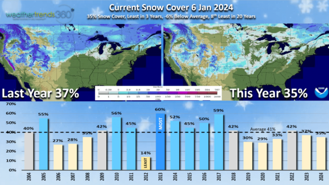
Snow Cover this morning shows 35% of the U.S. with some snow on the ground compared to 37% last year and 41% average. This is the least coverage for this date in 3 years.
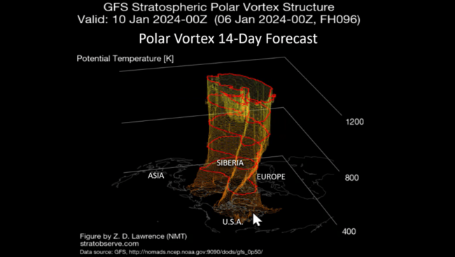
The good news is the Polar Vortex is making a major wobble toward North America with a big chunk diving into the U.S. as expected by WTI a year ahead. The entire country will be in the grip of the PV by MLK Jr week in middle January.
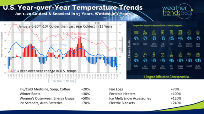
The first 3 weeks of January look to trend the coldest and snowiest in 13 years and wettest in 7 years for the U.S. overall. This will drive exceptional sales gains for Winter merchandise. With national temperatures trending -10F colder than a year ago, seasonal sales gains will be very strong. Applying WTI's Power of 1 Degree technology: flu/cold medicine, soup, coffee sales up +20% vs LY, Winter boots +30%, Women's Outerwear +50%, Ice Scrapers/Auto Batteries/firelogs +70%, Portable Heaters +100%, Ice Melt/Snow Accessories +120% and Electric Blankets +240%. Much needed sales gains after the mild November - December.
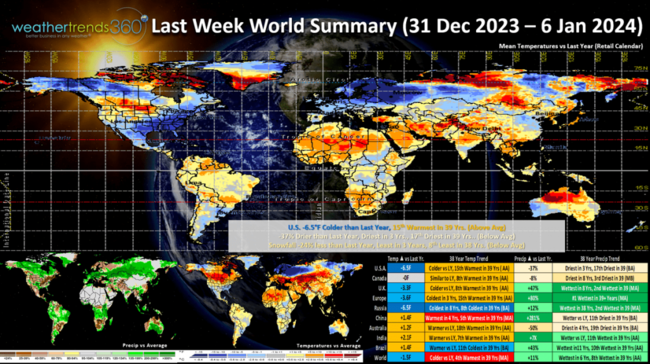
Last week (31 Dec - 6 Jan 2024) across the World shows the U.S. trending -6.5F colder than last year, 15th warmest of the past 39 years. -37% drier vs last year, driest in 3 years and 17th driest of the past 39 years. Snowfall also down -24%, least in 3 years and 8th least of the past 39 years. This was the start of improving trends for must have Winter merchandise. Russia was the cold spot while China the hot spot relative to this time of year.
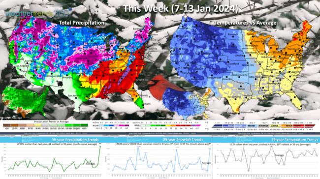
This Week (7-13 Jan) shows the start of the Polar Vortex plunge into the U.S. going from West to East. The U.S. overall trends -5.2F colder than last year, coldest in 8 years and 19th coldest of the past 39. Snowfall off the scale, trending +794% more than last year, most in 13 years and 3rd most of the past 39 years. The snowfall depicted in the Central U.S. is model over imagination, about half this much but still a snowy pattern. Rainfall also #1 most in 39 years. This will drive very strong demand for snow and wet weather categories across much of the country.
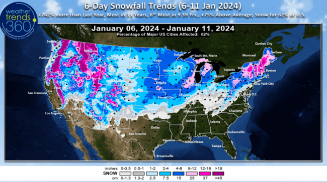
The 6-day snowfall outlook shows the bigger Nor'easter and then another early week system for the Central U.S. Overall the 6-day period trends +742% more last year, most in 13 years, 6th most in 39 years, +75% above average with 62% of the U.S. getting some snow.
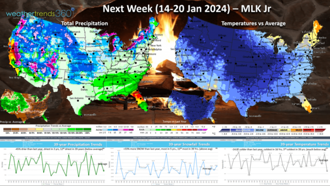
Next week (14-20 Jan) MLK Jr shows nearly the entire U.S. in the grip of the Polar Vortex with the U.S. trending a very significant -14F colder than last year, coldest in 16 years and 3rd coldest of the past 39 years. Snowfall +33% more than a year ago, most in 5 years and 11th most of the past 39 years. Rainfall down -45%, driest in 3 years and 12th driest in 39 years. TBD as there remains an active storm track around the PV. This should be an exceptionally strong week for Winter merchandise sales.
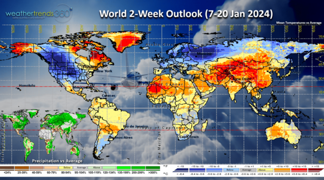
The World 2-week outlook (7-20 Jan) shows the Polar Vortex primarily impacting North America and Southwest Russia while Asia is very warm.
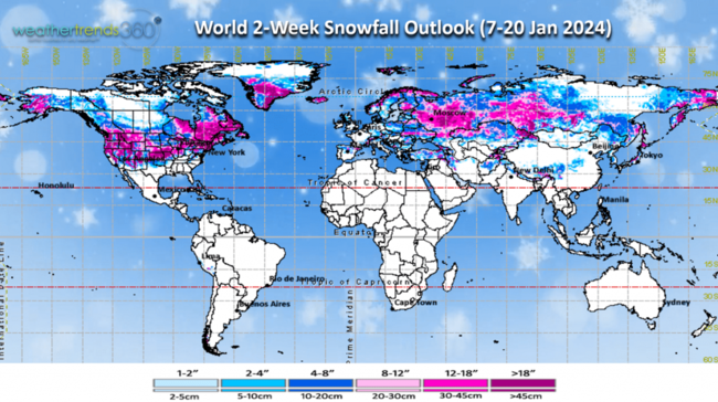
The 2-week World snowfall outlook shows much of the U.S., Eastern Canada and much of Russia the big winners for heavy snow.
Have a great week ahead, and don't forget to follow us on social media for frequent updates: Facebook, Twitter, YouTube, Pinterest and Linkedin.
- Captain Kirk out
The first moderate snow event of the season for us here at wt360 HQ in Bethlehem, PA. wt360 weather Cam South overlooking Bethlehem/Lehigh University shows the snow moving in. CLICK ON IMAGES FOR A LARGER VIEW.

We'll add to the anemic U.S. snow totals this season which are -58% less than a year ago and -58% below average making it the #1 least snowfall in over 39 years. This will change for the back half of Winter with major improvement here in January.

Snow Cover this morning shows 35% of the U.S. with some snow on the ground compared to 37% last year and 41% average. This is the least coverage for this date in 3 years.

The good news is the Polar Vortex is making a major wobble toward North America with a big chunk diving into the U.S. as expected by WTI a year ahead. The entire country will be in the grip of the PV by MLK Jr week in middle January.

The first 3 weeks of January look to trend the coldest and snowiest in 13 years and wettest in 7 years for the U.S. overall. This will drive exceptional sales gains for Winter merchandise. With national temperatures trending -10F colder than a year ago, seasonal sales gains will be very strong. Applying WTI's Power of 1 Degree technology: flu/cold medicine, soup, coffee sales up +20% vs LY, Winter boots +30%, Women's Outerwear +50%, Ice Scrapers/Auto Batteries/firelogs +70%, Portable Heaters +100%, Ice Melt/Snow Accessories +120% and Electric Blankets +240%. Much needed sales gains after the mild November - December.

Last week (31 Dec - 6 Jan 2024) across the World shows the U.S. trending -6.5F colder than last year, 15th warmest of the past 39 years. -37% drier vs last year, driest in 3 years and 17th driest of the past 39 years. Snowfall also down -24%, least in 3 years and 8th least of the past 39 years. This was the start of improving trends for must have Winter merchandise. Russia was the cold spot while China the hot spot relative to this time of year.

This Week (7-13 Jan) shows the start of the Polar Vortex plunge into the U.S. going from West to East. The U.S. overall trends -5.2F colder than last year, coldest in 8 years and 19th coldest of the past 39. Snowfall off the scale, trending +794% more than last year, most in 13 years and 3rd most of the past 39 years. The snowfall depicted in the Central U.S. is model over imagination, about half this much but still a snowy pattern. Rainfall also #1 most in 39 years. This will drive very strong demand for snow and wet weather categories across much of the country.

The 6-day snowfall outlook shows the bigger Nor'easter and then another early week system for the Central U.S. Overall the 6-day period trends +742% more last year, most in 13 years, 6th most in 39 years, +75% above average with 62% of the U.S. getting some snow.

Next week (14-20 Jan) MLK Jr shows nearly the entire U.S. in the grip of the Polar Vortex with the U.S. trending a very significant -14F colder than last year, coldest in 16 years and 3rd coldest of the past 39 years. Snowfall +33% more than a year ago, most in 5 years and 11th most of the past 39 years. Rainfall down -45%, driest in 3 years and 12th driest in 39 years. TBD as there remains an active storm track around the PV. This should be an exceptionally strong week for Winter merchandise sales.

The World 2-week outlook (7-20 Jan) shows the Polar Vortex primarily impacting North America and Southwest Russia while Asia is very warm.

The 2-week World snowfall outlook shows much of the U.S., Eastern Canada and much of Russia the big winners for heavy snow.
Have a great week ahead, and don't forget to follow us on social media for frequent updates: Facebook, Twitter, YouTube, Pinterest and Linkedin.
- Captain Kirk out