Captain's Log 9 Dec '23 Wholesale Change Warmer vs Last Year's COLD
Captain's Log
9 Dec '23: Happy Saturday! :)
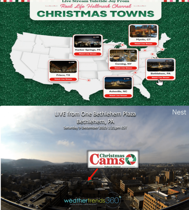
Can you believe there are only 15 days until Christmas? Here in Christmas City USA - Bethlehem PA - we have the Hallmark Channel live streaming the season as seen from Main Street looking south toward Hotel Bethlehem (#1 historic hotel in America 3 years running) and our very own Star of Bethlehem up on the hill south of Lehigh University. If you need a fun day trip this holiday season, we're it. CLICK ON IMAGES FOR A LARGER VIEW.
 You can watch the weather here in Bethlehem live with wt360 panoramic weather cameras: https://www.weathertrends360.com/Weather-Cams
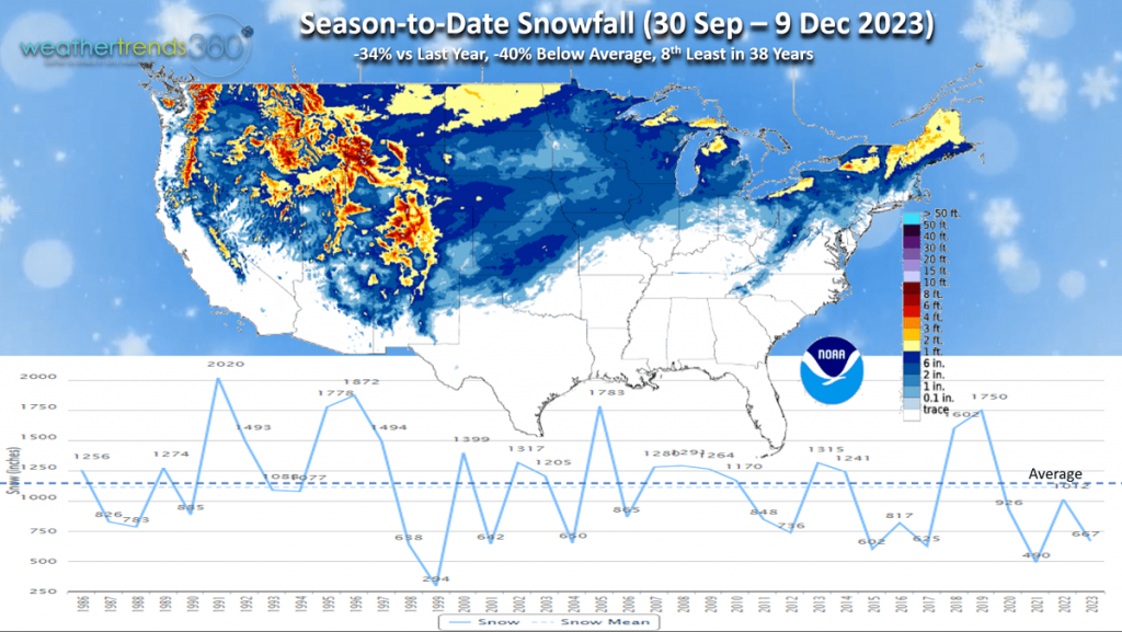 Unlike last year, the days leading up to Christmas are MUCH WARMER and LESS SNOWY than a year ago as wt360 projected a year ago. Season-to-date snowfall is down -34% vs last year, -40% below average and 8th least of the past 38 years.
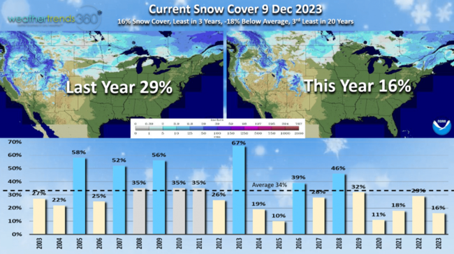
Snow cover this morning isn't much better with just 16% of the U.S. blanketed in snow vs 29% last year. Notice the dramatically less snow in the Western U.S. while New England is the bigger winner so far this season. An average snow cover for this time of year would be closer to 34%.
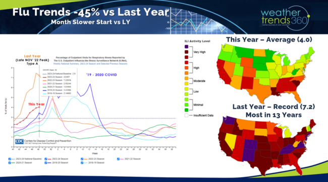
One big benefit of the much warmer Fall this year is a -45% decline in Flu cases vs a year ago. Last year Flu had the earliest spike in 13 years with an unusual Thanksgiving spike. A healthier population during the holiday season is a minor plus for retail sales.
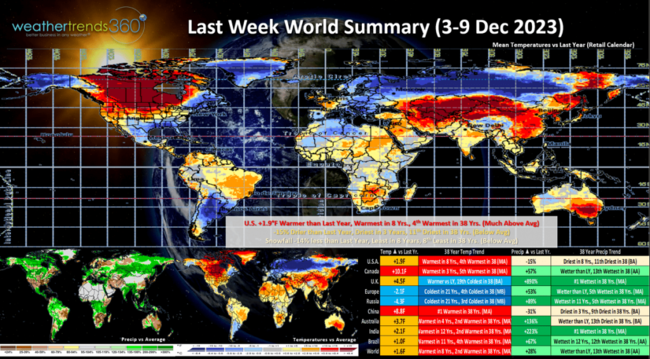
Last week (3-9 Dec) across the World shows the U.S. trending +1.9F warmer than last year, warmest in 8 years and 4th warmest of the past 38 years. The bright spot of Fall with colder weather was the Black Friday weekend, but that was short lived and now a prolonged stretch of unfavorable weather for seasonal sales. Rainfall was -15% drier than a year ago, driest in 3 years and 11th driest of the past 38 years. Snowfall was also way down nationally, -14% vs last year, least in 8 years and 8th least in 38 years. Expect strong double-digit declines in seasonal sales going into Christmas. Some hope after that.
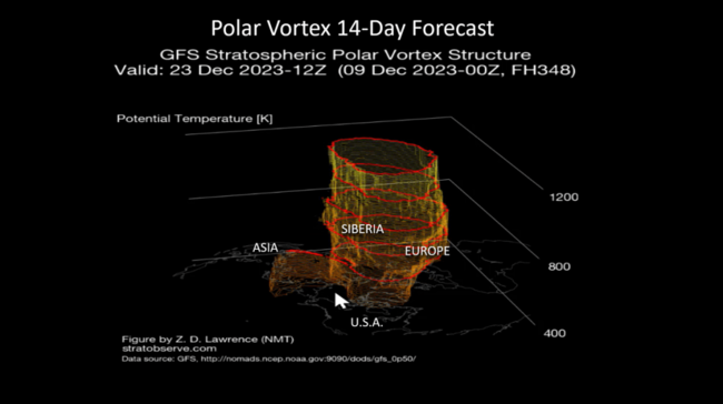
Not too hard to find the Polar Vortex cold which was camped out over Europe, Russia and Siberia. But signs it's about to make a move and head toward China and eventually North America late month.
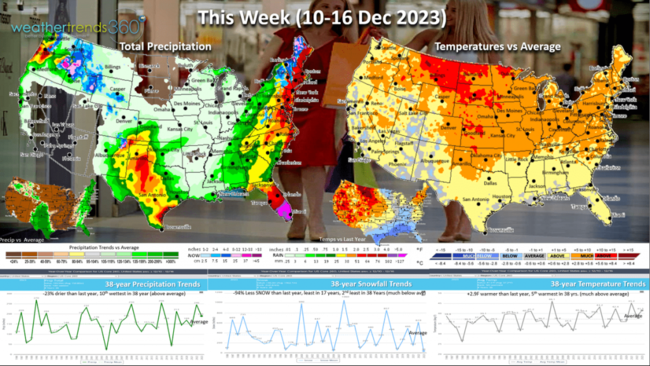
This week (10-16 Dec) shows the U.S. trending +2.9F warmer than last year and 5th warmest of the past 38 years. Rainfall down -23% vs a year ago but still 10th wettest of the past 38 years while snowfall is down a whopping -94% vs last year, least in 17 years and 2nd least in 38 years. Some benefit to store traffic with warmer/drier trends, but a huge negative for Winter seasonal merchandise. The week starts off very wet along the East coast that will end as heavier snow in the higher terrain, a frequent pattern this Winter!
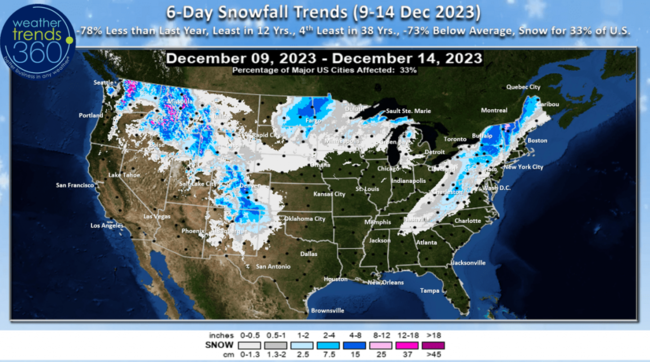
The 6-day snowfall trends (9-14 Dec) shows -78% less snow than a year ago, -73% below average, least in 12 years, 4th least in 38 years with 33% of the U.S. getting some snow.
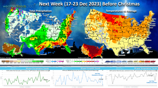
Next week (17-23 Dec) BEFORE CHRISTMAS shows a wholesale change from last year when the days leading up to Christmas were the coldest in 22 years and snowiest in 13 years...NOT THIS YEAR. National temperatures a near record +16F warmer than a year ago, warmest in 4 years and 4th warmest of the past 38 years. Snowfall -97% vs last year and #1 least in over 38 years. Rainfall +13% vs last year, most in 3 years but still 18th driest of the past 38 years. These are favorable trends for store traffic and gift sales, but at the expense of Winter seasonal merchandise that will be on major discount to clear mounting inventory.
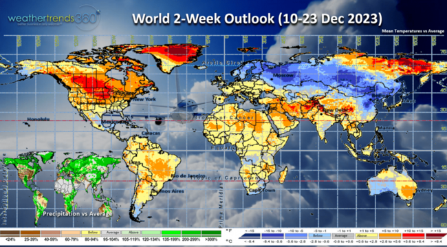
The World 2-week outlook (10-23 Dec) shows the Polar Vortex will wobble and weaken a bit allowing the Arctic air to invade China and eventually North America late December into January.
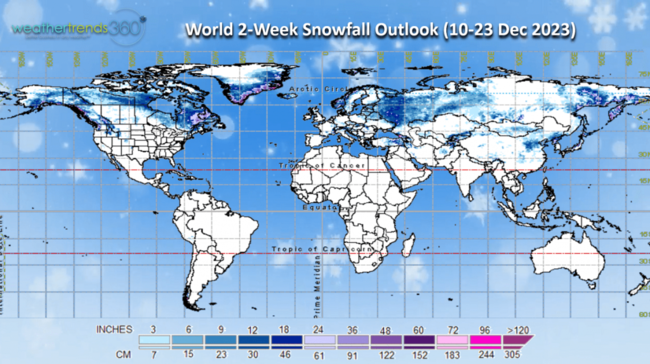
World snowfall shows snow continuing to pile up in Eastern Canada which in part will allow SE Canada and the NE U.S. to have a much colder core Winter in the weeks-months ahead.
Have a great week ahead, and don't forget to follow us on social media for frequent updates: Facebook, Twitter, YouTube, Pinterest and Linkedin.
- Captain Kirk out
Can you believe there are only 15 days until Christmas? Here in Christmas City USA - Bethlehem PA - we have the Hallmark Channel live streaming the season as seen from Main Street looking south toward Hotel Bethlehem (#1 historic hotel in America 3 years running) and our very own Star of Bethlehem up on the hill south of Lehigh University. If you need a fun day trip this holiday season, we're it. CLICK ON IMAGES FOR A LARGER VIEW.
 You can watch the weather here in Bethlehem live with wt360 panoramic weather cameras: https://www.weathertrends360.com/Weather-Cams
  Unlike last year, the days leading up to Christmas are MUCH WARMER and LESS SNOWY than a year ago as wt360 projected a year ago. Season-to-date snowfall is down -34% vs last year, -40% below average and 8th least of the past 38 years.
Snow cover this morning isn't much better with just 16% of the U.S. blanketed in snow vs 29% last year. Notice the dramatically less snow in the Western U.S. while New England is the bigger winner so far this season. An average snow cover for this time of year would be closer to 34%.

One big benefit of the much warmer Fall this year is a -45% decline in Flu cases vs a year ago. Last year Flu had the earliest spike in 13 years with an unusual Thanksgiving spike. A healthier population during the holiday season is a minor plus for retail sales.

Last week (3-9 Dec) across the World shows the U.S. trending +1.9F warmer than last year, warmest in 8 years and 4th warmest of the past 38 years. The bright spot of Fall with colder weather was the Black Friday weekend, but that was short lived and now a prolonged stretch of unfavorable weather for seasonal sales. Rainfall was -15% drier than a year ago, driest in 3 years and 11th driest of the past 38 years. Snowfall was also way down nationally, -14% vs last year, least in 8 years and 8th least in 38 years. Expect strong double-digit declines in seasonal sales going into Christmas. Some hope after that.

Not too hard to find the Polar Vortex cold which was camped out over Europe, Russia and Siberia. But signs it's about to make a move and head toward China and eventually North America late month.

This week (10-16 Dec) shows the U.S. trending +2.9F warmer than last year and 5th warmest of the past 38 years. Rainfall down -23% vs a year ago but still 10th wettest of the past 38 years while snowfall is down a whopping -94% vs last year, least in 17 years and 2nd least in 38 years. Some benefit to store traffic with warmer/drier trends, but a huge negative for Winter seasonal merchandise. The week starts off very wet along the East coast that will end as heavier snow in the higher terrain, a frequent pattern this Winter!

The 6-day snowfall trends (9-14 Dec) shows -78% less snow than a year ago, -73% below average, least in 12 years, 4th least in 38 years with 33% of the U.S. getting some snow.

Next week (17-23 Dec) BEFORE CHRISTMAS shows a wholesale change from last year when the days leading up to Christmas were the coldest in 22 years and snowiest in 13 years...NOT THIS YEAR. National temperatures a near record +16F warmer than a year ago, warmest in 4 years and 4th warmest of the past 38 years. Snowfall -97% vs last year and #1 least in over 38 years. Rainfall +13% vs last year, most in 3 years but still 18th driest of the past 38 years. These are favorable trends for store traffic and gift sales, but at the expense of Winter seasonal merchandise that will be on major discount to clear mounting inventory.

The World 2-week outlook (10-23 Dec) shows the Polar Vortex will wobble and weaken a bit allowing the Arctic air to invade China and eventually North America late December into January.

World snowfall shows snow continuing to pile up in Eastern Canada which in part will allow SE Canada and the NE U.S. to have a much colder core Winter in the weeks-months ahead.
Have a great week ahead, and don't forget to follow us on social media for frequent updates: Facebook, Twitter, YouTube, Pinterest and Linkedin.
- Captain Kirk out