Captain's Log 9 Mar '24 U.S. Wettest March in 40+ Years!
Captain's Log
9 March 2024: Happy Saturday :)
62% of Americans want to stop changing the clocks twice a year, but here we are changing them again tonight. Don't forget to Spring Forward at 2am as Daylight Saving Time starts. CLICK ON IMAGES FOR A LARGER VIEW

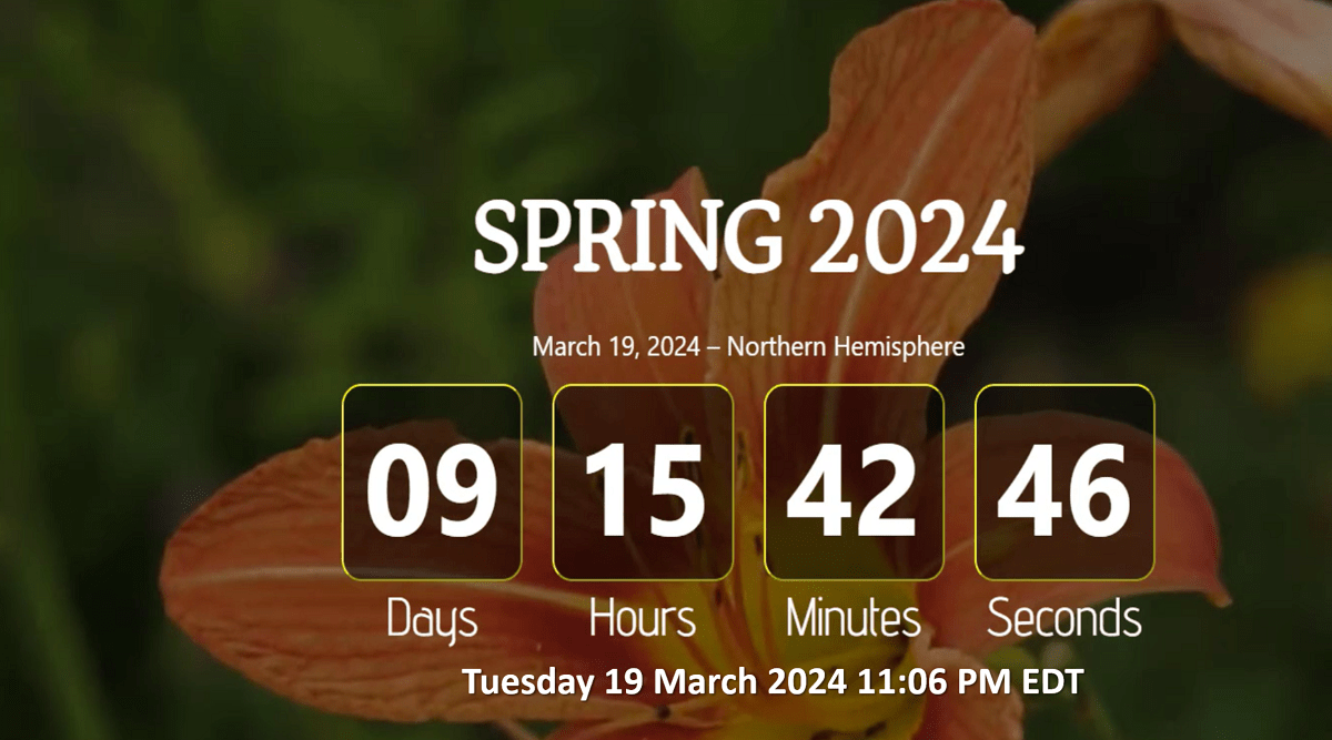
One thing we can't change and that's the arrival of Spring in just over 9 days on Tuesday 19 March at 11:06pm EDT.

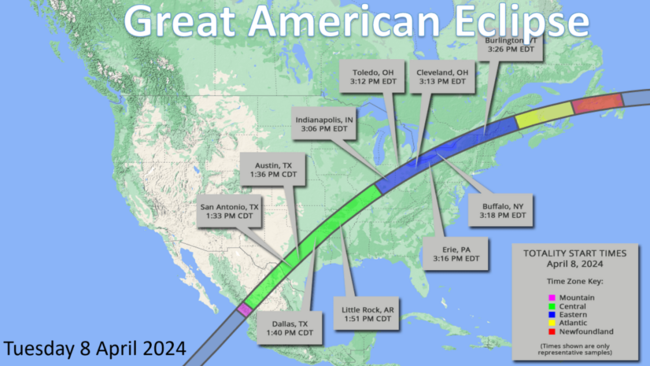
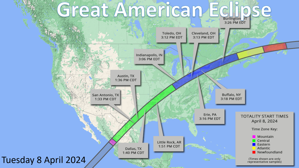
And we're just a month away from the Great American Solar Eclipse that will bring a 100% solar eclipse from Texas to Maine on Tuesday 8 April 2024. Anyone in this band will have 3-4 minutes of totality with the day turning to twilight dark and very likely a 10F temperature drop.
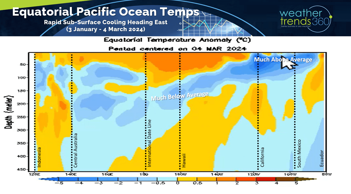
The colder than average water temperatures have already come to the surface in the Eastern Equatorial Pacific Ocean indicating La Niña is developing rapidly and expected to moderate to strong by Summer.
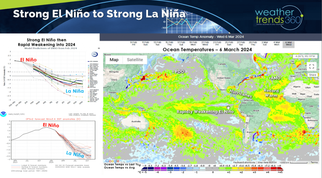

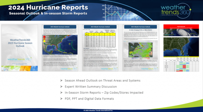
This rapid change will again create havoc with World weather patterns. wt360 clients should check their Friday email for our 2024 Hurricane Season Outlook which looks to be a top 3 most active in 165+ years with highest risk for Texas.
With El Niño we had a very warm Equatorial Pacific Ocean that did not entirely create an atmospheric weather response as the broader Pacific Ocean and the Southwest Pacific Ocean was also warm, a typical. We still had a lot of moisture pumped into the atmosphere in part explaining why 2024 is off to the wettest start in the U.S. in 26 years. The next couple weeks are even wetter!
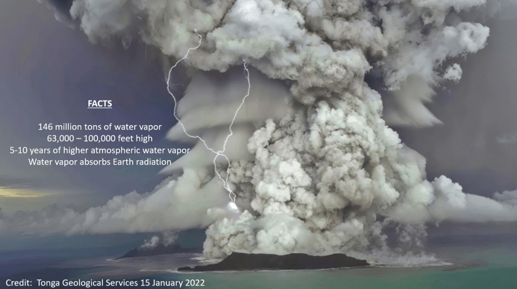
The other major factor for all the moisture in the atmosphere is the Tonga volcano eruption back in January 2022 that pumped 146 million tons of water vapor 63,000 to 100,000 feet into the atmosphere. This moisture is very likely stuck for another 3-8 years contributing to an overall wet World. Water vapor in the atmosphere also acts as a greenhouse gas that traps Earth infrared radiation making it warmer overall.

One of the worst U.S. droughts peaked in Nov 2022 when over 82% of the country was in dry to drought phases, now we're at 47% which is below average (wet) and least drought coverage in 4 years. This will improve in the Spring season ahead.
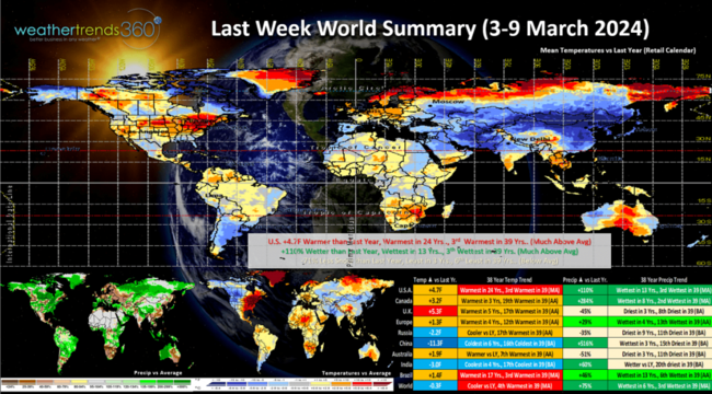
Last Week (3-9 March) across the World shows the U.S. trending +4.7F warmer than last year, warmest in 24 years and 3rd warmest of the past 39. The Northwest was the cooler spot while the Northeast was Spring-like. Rainfall was up +110% vs last year, most in 13 years and 3rd wettest of the past 39 years. While snowfall was down in the major population centers, -71% vs last year, least in 3 years, it was excessive in the high mountains of the West. This time of year, warmer and drier weather is more favorable for retail and Spring seasonal sales.
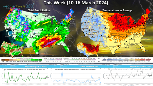
This week (10-16 March) shows how even an overall warm pattern can still bring snow with the higher terrain of the Northeast getting moderate snow. U.S. temperatures overall are +9.1F warmer than last year's cold week, warmest in 8 years and 6th warmest of the past 39 years. The West is the cooler spot. Rainfall up +4% vs last year, most in 8 years and 8th most in 39 years while national snowfall is down -84% vs last year, least in 8 years and 7th least in 39 years. Still some lingering severe weather/tornado threats in the Southeast before the front sweeps off the coast.
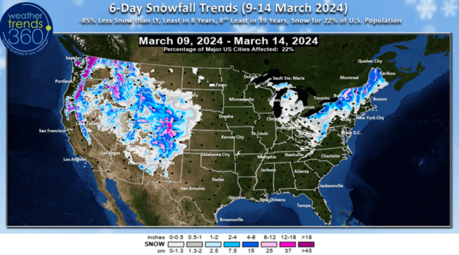
The 6-day snowfall (9-14 March) shows -85% less snow than last year, least in 8 years and 8th least of the past 39 years with 22% of the U.S. population getting some snow. Heavier snow continues in the mountains of the West and New England.
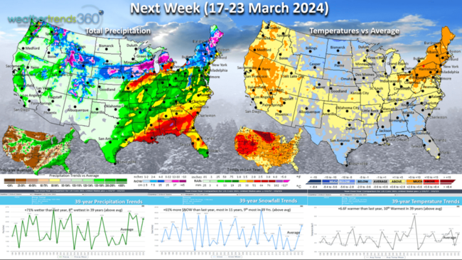
Next week (17-23 March) temperatures begin to moderate a bit with national temperatures +6.6F warmer than last year's really cold March period. Rainfall again up +71% vs last year and 8th wettest of the past 39 years while snowfall is also way up +61% vs last year, most in 11 years and 9th most in 39 years with more snow for New England and the Central Plains.
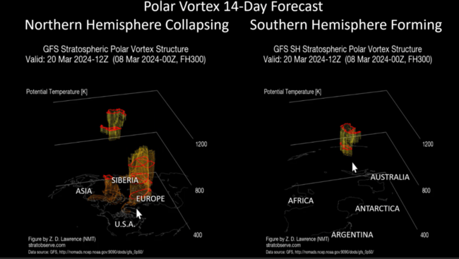
The Polar Vortex is showing its annual collapse at the North Pole, but signs of forming at the South Pole. As the Polar Vortex weakens in the Spring, it does allow for remaining cold Polar airmasses to move more freely and wt360 does expect some significant cold snaps in April and early May with some late frost and freezes.

The World 2-week outlook (10-23 March) shows the cold limited to Central Siberia, Alaska and Argentina.
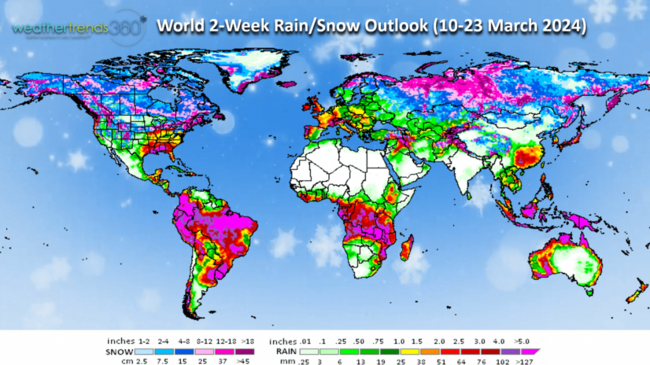
Very wet conditions for the U.S. Corn Belt with heavier rain for eastern Iowa and ample rainfall in Brazil's crop regions.
We hope you have a great week ahead, and don't forget to follow us on social media for frequent updates: Facebook, Twitter, YouTube, Pinterest and Linkedin.
- Captain Kirk out
62% of Americans want to stop changing the clocks twice a year, but here we are changing them again tonight. Don't forget to Spring Forward at 2am as Daylight Saving Time starts. CLICK ON IMAGES FOR A LARGER VIEW

One thing we can't change and that's the arrival of Spring in just over 9 days on Tuesday 19 March at 11:06pm EDT.
And we're just a month away from the Great American Solar Eclipse that will bring a 100% solar eclipse from Texas to Maine on Tuesday 8 April 2024. Anyone in this band will have 3-4 minutes of totality with the day turning to twilight dark and very likely a 10F temperature drop.
The colder than average water temperatures have already come to the surface in the Eastern Equatorial Pacific Ocean indicating La Niña is developing rapidly and expected to moderate to strong by Summer.
This rapid change will again create havoc with World weather patterns. wt360 clients should check their Friday email for our 2024 Hurricane Season Outlook which looks to be a top 3 most active in 165+ years with highest risk for Texas.

With El Niño we had a very warm Equatorial Pacific Ocean that did not entirely create an atmospheric weather response as the broader Pacific Ocean and the Southwest Pacific Ocean was also warm, a typical. We still had a lot of moisture pumped into the atmosphere in part explaining why 2024 is off to the wettest start in the U.S. in 26 years. The next couple weeks are even wetter!
The other major factor for all the moisture in the atmosphere is the Tonga volcano eruption back in January 2022 that pumped 146 million tons of water vapor 63,000 to 100,000 feet into the atmosphere. This moisture is very likely stuck for another 3-8 years contributing to an overall wet World. Water vapor in the atmosphere also acts as a greenhouse gas that traps Earth infrared radiation making it warmer overall.
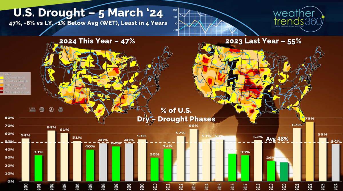
One of the worst U.S. droughts peaked in Nov 2022 when over 82% of the country was in dry to drought phases, now we're at 47% which is below average (wet) and least drought coverage in 4 years. This will improve in the Spring season ahead.
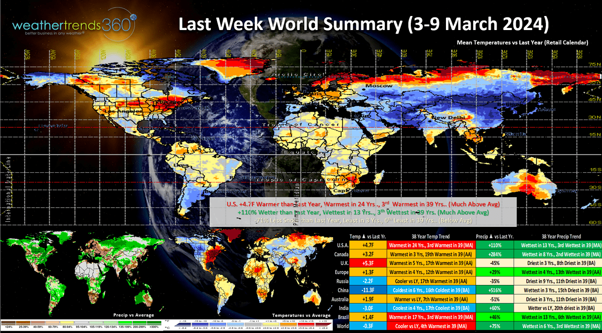
Last Week (3-9 March) across the World shows the U.S. trending +4.7F warmer than last year, warmest in 24 years and 3rd warmest of the past 39. The Northwest was the cooler spot while the Northeast was Spring-like. Rainfall was up +110% vs last year, most in 13 years and 3rd wettest of the past 39 years. While snowfall was down in the major population centers, -71% vs last year, least in 3 years, it was excessive in the high mountains of the West. This time of year, warmer and drier weather is more favorable for retail and Spring seasonal sales.
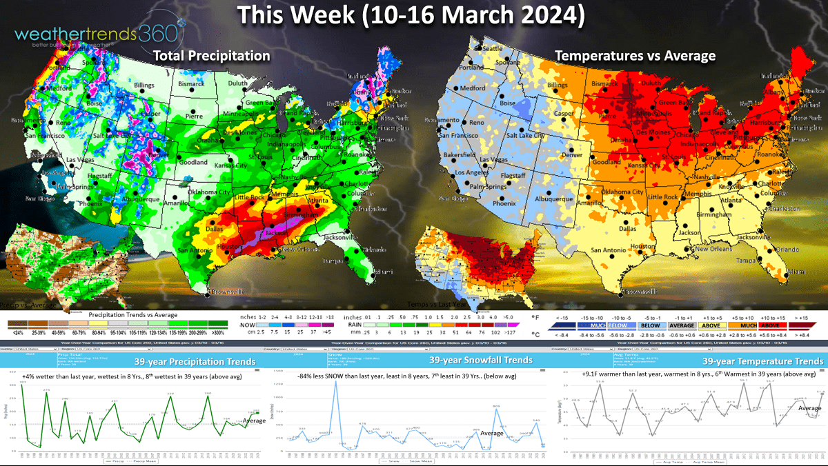
This week (10-16 March) shows how even an overall warm pattern can still bring snow with the higher terrain of the Northeast getting moderate snow. U.S. temperatures overall are +9.1F warmer than last year's cold week, warmest in 8 years and 6th warmest of the past 39 years. The West is the cooler spot. Rainfall up +4% vs last year, most in 8 years and 8th most in 39 years while national snowfall is down -84% vs last year, least in 8 years and 7th least in 39 years. Still some lingering severe weather/tornado threats in the Southeast before the front sweeps off the coast.
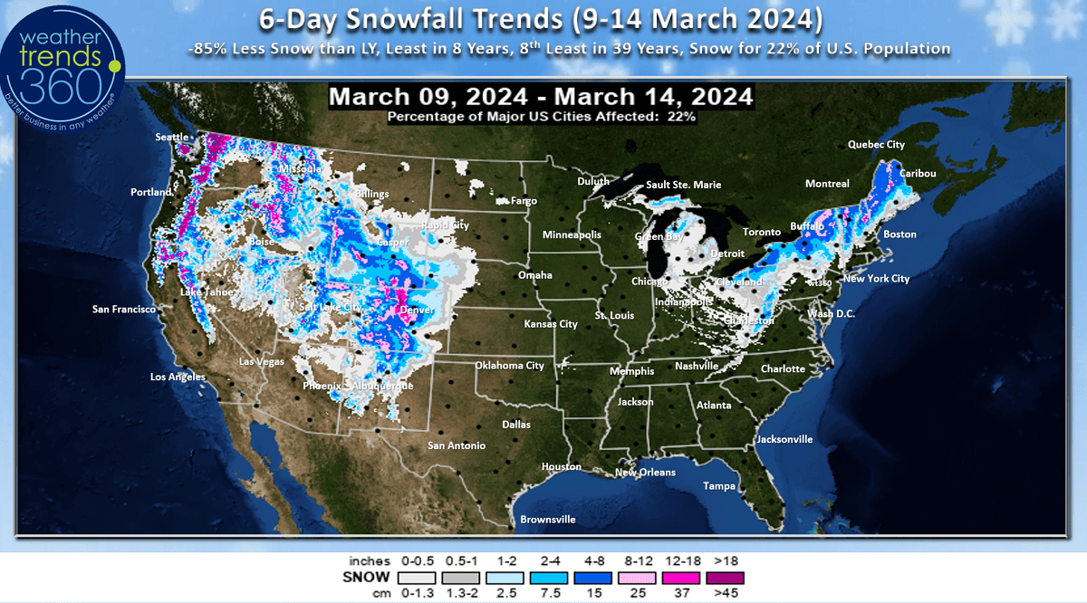
The 6-day snowfall (9-14 March) shows -85% less snow than last year, least in 8 years and 8th least of the past 39 years with 22% of the U.S. population getting some snow. Heavier snow continues in the mountains of the West and New England.
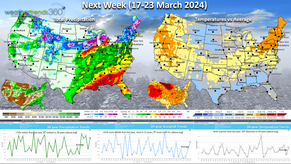
Next week (17-23 March) temperatures begin to moderate a bit with national temperatures +6.6F warmer than last year's really cold March period. Rainfall again up +71% vs last year and 8th wettest of the past 39 years while snowfall is also way up +61% vs last year, most in 11 years and 9th most in 39 years with more snow for New England and the Central Plains.
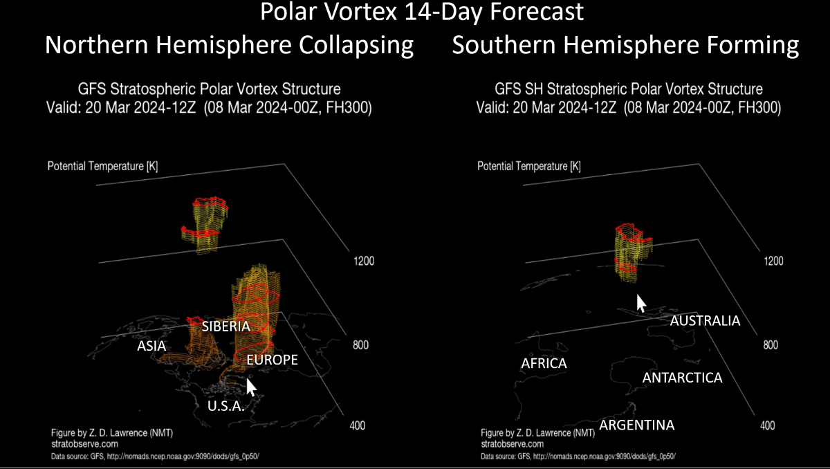
The Polar Vortex is showing its annual collapse at the North Pole, but signs of forming at the South Pole. As the Polar Vortex weakens in the Spring, it does allow for remaining cold Polar airmasses to move more freely and wt360 does expect some significant cold snaps in April and early May with some late frost and freezes.
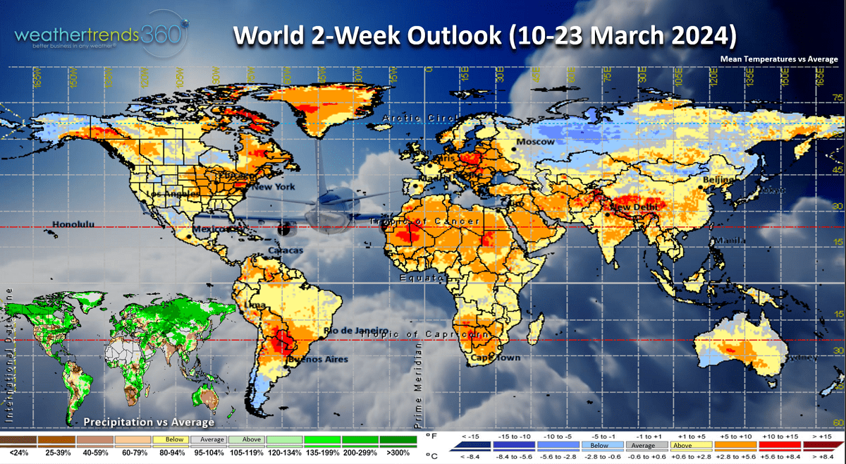
The World 2-week outlook (10-23 March) shows the cold limited to Central Siberia, Alaska and Argentina.

Very wet conditions for the U.S. Corn Belt with heavier rain for eastern Iowa and ample rainfall in Brazil's crop regions.
We hope you have a great week ahead, and don't forget to follow us on social media for frequent updates: Facebook, Twitter, YouTube, Pinterest and Linkedin.
- Captain Kirk out