December 2016 World Weather Summary
Business
U.S. December 2016 Overview
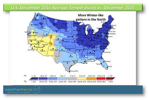
December 2016 was the coldest in 3 years for the U.S. as a whole with drastic changes to colder weather compared to record warm weather last year across the Plains, Midwest, and Northeast (see map of temperatures compared to last year below). The most significant Arctic outbreaks since the winter of 2014/2015 descended on the nation bringing widespread cold weather. The middle of December featured the coldest weather, but around Christmas Day warmer weather arrived in the South. Snowfall was the greatest in 3 years for the U.S. as a whole with greater snow across the North. The spring-like weather of December 2015 became a distant memory as December 2016 thrust the U.S. back into reality with colder and snowier weather.
Northeast:
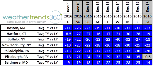
Temperatures trended the coldest in 3 years for December as a whole and closer to normal. Even though temperatures were closer to normal, the year-on-year change to colder weather from record warmth in December 2015 was one of the greatest in 121 years of record. For many of the major Northeast cities, the average temperature for December 2016 as a whole was about 10F to 12F colder compared to 2015. On individual days, particularly around mid-December, some locations saw temperatures that were 30F and even 40F colder compared to the same day last year as seen in the chart below.
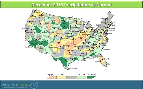
Total liquid precipitation was the least in 6 years for the Northeast, however, snowfall was the most in 3 years and much greater than the least snowy December in 25+ years in 2015. A winter storm brought snow, ice, and rain to the major cities in the weekend prior to Christmas. Most of the precipitation changed over to rain leaving behind a slushy mess, while areas farther inland saw more snow and ice. Another winter storm in the last few days of December brought several inches of snow to New England with the ski resorts farther inland seeing over a foot of snow. There were a couple of blasts of Arctic air during the month and with each round of Arctic air the lake effect snow machine would kick into high gear. Locally, areas downwind of the Great Lakes picked up some significant snowfall.
North Central:
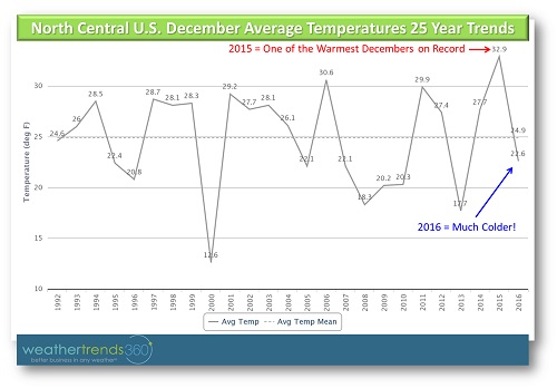
Like the Northeast, temperatures were drastically colder compared to a record warm December 2015 with some of the greatest changes to colder weather on record (121 years). For the month overall, temperatures in many of the major cities were 10F colder than last year, and like the Northeast, individual days trended much colder with several cities seeing days that were 40F colder than the same day last year. Bismarck, ND on December 9th was an incredible 56F colder compared to the same date in 2015 with the temperature topping out only in the single digits.
The region was subject to several winter storms, with the first 3 weekends of the month featuring accumulating snowfall. A Christmas Day blizzard pummeled portions of the northern Plains, including Bismarck where over a foot of snow fell. In fact, snowfall for Bismarck for the season so far (through January 2nd) is the most on record for the city at 53.1''. This was the snowiest December in 3 years for the North Central region as a whole.
Northwest:
December 2016 was particularly cold and similar temperature-wise to the very cold Decembers of 2013 and 2009, making this one of the coldest Decembers in 25+ years for the region as a whole. For Seattle and Portland, this was the 3rd coldest December in 25+ years. Snowfall was also well above normal in the Northwest with some light snow in Portland and Oregon but heavier snow in the higher elevations. Portland set a new daily snowfall record on December 14th with 2.3'' of snow falling on the city.
Southwest:
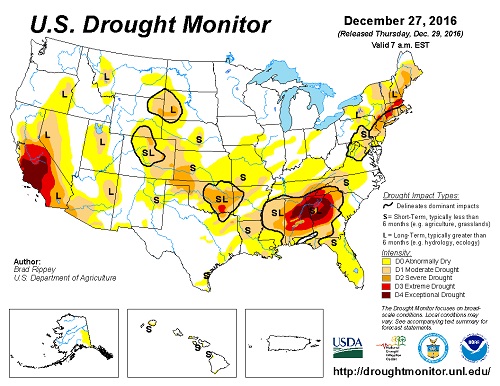
The Southwest and Southern Rocky Mountains were the outsiders this month with temperatures trending warmer than 2015 and above normal. Precipitation was greater than normal as several storm systems impacted the region. Even southern California was slightly wetter than normal which is positive news in an area plagued by long-term drought (see drought map below). Snowfall, however, in the Southwest and Southern Rocky Mountains was nothing to write home about with snow trending below normal for December.
South Central:
December was the coldest in 3 years for the South Central U.S. but still slightly warmer than normal. An outbreak of Arctic air around mid-December brought temperatures near freezing as far as the Gulf Coast, but the timeframe around and just after Christmas was very warm. In fact, several new daily high temperature records were set in the timeframe around Christmas Day as temperatures climbed into the 80s across East and Central Texas. The 80F temperatures came just a little over a week after highs only reached into the 30s for Dallas.
While precipitation was less than the prior year, precipitation was above normal for the South Central U.S. as a whole. The wettest weather occurred during the first and last days of the month and was focused in South Texas and closer to the Gulf Coast. Very heavy rain during the last day of December and into the first couple of days of January led to flooding across parts of the Gulf Coast.
Southeast:
Above normal precipitation was a common theme across the South in December 2016 and the Southeast was no exception as precipitation was the 6th most in 25+ years. After a very dry autumn and on the heels of the devastating wildfires in Gatlinburg, TN, wetter weather finally returned to the Southeast. Although not eradicated, the rain helped to ease drought in some parts of the Southeast. Despite the increase in rainfall, significant drought still exists in the Southeast which is evident in the drought map posted above.
Temperatures were much colder than a very warm December 2015, but were still above normal. Florida was particularly warm and trended colder only than 2015, which was the warmest December in 25+ years; 2016 was the 2nd warmest December in 25+ years for the state.
Snowfall was limited during December in the Southeast with only a very small amount falling across the entire region. Technically, this was the snowiest December in 3 years, but less than an inch of snow fell in the region.
Global December 2016 Overview
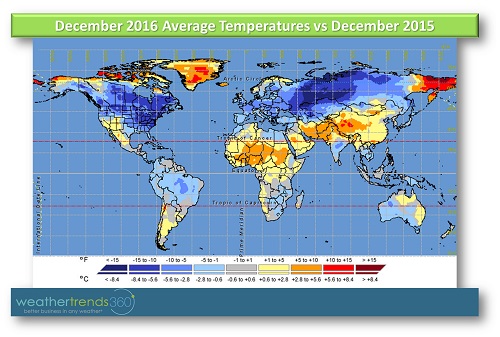
The drastically much colder temperature trends in the northern U.S. were mirrored in Canada where December 2016 was the coldest in 3 years and almost 10F colder than 2015. In December 2016, 97% of Canada trended colder than 2015. Vancouver was a winter wonderland with several rounds of snow and the 2nd coldest December in 25+ years. A Christmas Day blizzard, which also impacted the U.S. northern Plains, brought heavy snow and strong winds to southern Manitoba and western Ontario. Several intense storm systems early in the month caused power outages and road closures in Atlantic Canada as strong winds, heavy rain, and snow pummeled the region. Snowfall for Canada as a whole was the most in 3 years.
Much colder year-on-year trends also extended across a large part of Europe and Russia with Europe trending closer to normal and Russia slightly below normal. Warmer temperature trends could be found in China, the Middle East, and Western Africa. South of the Equator, Australia experienced its warmest December in 25+ years, although it was similar temperature-wise to 2015. In fact, Sydney recorded its hottest nighttime temperature on December 13th.
Temperatures were also on the warm side in India where December 2016 tied 2015 as the 2nd warmest in 25+ years. Cyclone Vardah tore a path of destruction across the Bay of Bengal as the first cyclone of the season for this area. This was the most intense cyclone to impact Chennai, India in over 20 years.
December 2016 was wetter than 2015 in Brazil, however, this was still the 7th driest December in 25+ years for the country. The exception was in southern parts of Brazil where this was the 3rd wettest December in 25+ years. Temperatures for Brazil as a whole were closer to normal with slightly above normal temperatures in the East and slightly below normal temperatures in the West.
December 2016 was the coldest in 3 years for the U.S. as a whole with drastic changes to colder weather compared to record warm weather last year across the Plains, Midwest, and Northeast (see map of temperatures compared to last year below). The most significant Arctic outbreaks since the winter of 2014/2015 descended on the nation bringing widespread cold weather. The middle of December featured the coldest weather, but around Christmas Day warmer weather arrived in the South. Snowfall was the greatest in 3 years for the U.S. as a whole with greater snow across the North. The spring-like weather of December 2015 became a distant memory as December 2016 thrust the U.S. back into reality with colder and snowier weather.
Northeast:
Temperatures trended the coldest in 3 years for December as a whole and closer to normal. Even though temperatures were closer to normal, the year-on-year change to colder weather from record warmth in December 2015 was one of the greatest in 121 years of record. For many of the major Northeast cities, the average temperature for December 2016 as a whole was about 10F to 12F colder compared to 2015. On individual days, particularly around mid-December, some locations saw temperatures that were 30F and even 40F colder compared to the same day last year as seen in the chart below.
Total liquid precipitation was the least in 6 years for the Northeast, however, snowfall was the most in 3 years and much greater than the least snowy December in 25+ years in 2015. A winter storm brought snow, ice, and rain to the major cities in the weekend prior to Christmas. Most of the precipitation changed over to rain leaving behind a slushy mess, while areas farther inland saw more snow and ice. Another winter storm in the last few days of December brought several inches of snow to New England with the ski resorts farther inland seeing over a foot of snow. There were a couple of blasts of Arctic air during the month and with each round of Arctic air the lake effect snow machine would kick into high gear. Locally, areas downwind of the Great Lakes picked up some significant snowfall.
North Central:
Like the Northeast, temperatures were drastically colder compared to a record warm December 2015 with some of the greatest changes to colder weather on record (121 years). For the month overall, temperatures in many of the major cities were 10F colder than last year, and like the Northeast, individual days trended much colder with several cities seeing days that were 40F colder than the same day last year. Bismarck, ND on December 9th was an incredible 56F colder compared to the same date in 2015 with the temperature topping out only in the single digits.
The region was subject to several winter storms, with the first 3 weekends of the month featuring accumulating snowfall. A Christmas Day blizzard pummeled portions of the northern Plains, including Bismarck where over a foot of snow fell. In fact, snowfall for Bismarck for the season so far (through January 2nd) is the most on record for the city at 53.1''. This was the snowiest December in 3 years for the North Central region as a whole.
Northwest:
December 2016 was particularly cold and similar temperature-wise to the very cold Decembers of 2013 and 2009, making this one of the coldest Decembers in 25+ years for the region as a whole. For Seattle and Portland, this was the 3rd coldest December in 25+ years. Snowfall was also well above normal in the Northwest with some light snow in Portland and Oregon but heavier snow in the higher elevations. Portland set a new daily snowfall record on December 14th with 2.3'' of snow falling on the city.
Southwest:
The Southwest and Southern Rocky Mountains were the outsiders this month with temperatures trending warmer than 2015 and above normal. Precipitation was greater than normal as several storm systems impacted the region. Even southern California was slightly wetter than normal which is positive news in an area plagued by long-term drought (see drought map below). Snowfall, however, in the Southwest and Southern Rocky Mountains was nothing to write home about with snow trending below normal for December.
South Central:
December was the coldest in 3 years for the South Central U.S. but still slightly warmer than normal. An outbreak of Arctic air around mid-December brought temperatures near freezing as far as the Gulf Coast, but the timeframe around and just after Christmas was very warm. In fact, several new daily high temperature records were set in the timeframe around Christmas Day as temperatures climbed into the 80s across East and Central Texas. The 80F temperatures came just a little over a week after highs only reached into the 30s for Dallas.
While precipitation was less than the prior year, precipitation was above normal for the South Central U.S. as a whole. The wettest weather occurred during the first and last days of the month and was focused in South Texas and closer to the Gulf Coast. Very heavy rain during the last day of December and into the first couple of days of January led to flooding across parts of the Gulf Coast.
Southeast:
Above normal precipitation was a common theme across the South in December 2016 and the Southeast was no exception as precipitation was the 6th most in 25+ years. After a very dry autumn and on the heels of the devastating wildfires in Gatlinburg, TN, wetter weather finally returned to the Southeast. Although not eradicated, the rain helped to ease drought in some parts of the Southeast. Despite the increase in rainfall, significant drought still exists in the Southeast which is evident in the drought map posted above.
Temperatures were much colder than a very warm December 2015, but were still above normal. Florida was particularly warm and trended colder only than 2015, which was the warmest December in 25+ years; 2016 was the 2nd warmest December in 25+ years for the state.
Snowfall was limited during December in the Southeast with only a very small amount falling across the entire region. Technically, this was the snowiest December in 3 years, but less than an inch of snow fell in the region.
Global December 2016 Overview
The drastically much colder temperature trends in the northern U.S. were mirrored in Canada where December 2016 was the coldest in 3 years and almost 10F colder than 2015. In December 2016, 97% of Canada trended colder than 2015. Vancouver was a winter wonderland with several rounds of snow and the 2nd coldest December in 25+ years. A Christmas Day blizzard, which also impacted the U.S. northern Plains, brought heavy snow and strong winds to southern Manitoba and western Ontario. Several intense storm systems early in the month caused power outages and road closures in Atlantic Canada as strong winds, heavy rain, and snow pummeled the region. Snowfall for Canada as a whole was the most in 3 years.
Much colder year-on-year trends also extended across a large part of Europe and Russia with Europe trending closer to normal and Russia slightly below normal. Warmer temperature trends could be found in China, the Middle East, and Western Africa. South of the Equator, Australia experienced its warmest December in 25+ years, although it was similar temperature-wise to 2015. In fact, Sydney recorded its hottest nighttime temperature on December 13th.
Temperatures were also on the warm side in India where December 2016 tied 2015 as the 2nd warmest in 25+ years. Cyclone Vardah tore a path of destruction across the Bay of Bengal as the first cyclone of the season for this area. This was the most intense cyclone to impact Chennai, India in over 20 years.
December 2016 was wetter than 2015 in Brazil, however, this was still the 7th driest December in 25+ years for the country. The exception was in southern parts of Brazil where this was the 3rd wettest December in 25+ years. Temperatures for Brazil as a whole were closer to normal with slightly above normal temperatures in the East and slightly below normal temperatures in the West.