Hurricane Florence Damage Projections
Breaking Weather Events
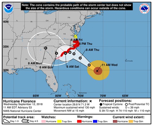
Preparations and evacuations are wrapping up today as Hurricane Florence closes in on the U.S. Florence remains a fierce, category 4 hurricane (winds +130 mph) and is likely to remain a major hurricane (category 3 or higher) as it nears the North Carolina coast late tomorrow and early Friday morning. This is going to be a long duration event as Florence will slow down significantly once nearing the coast resulting in catastrophic rainfall totals, storm surge flooding, wind damage, and significant beach erosion. Learn about the potential damage from Hurricane Florence below.
 Main messages for Hurricane Florence:
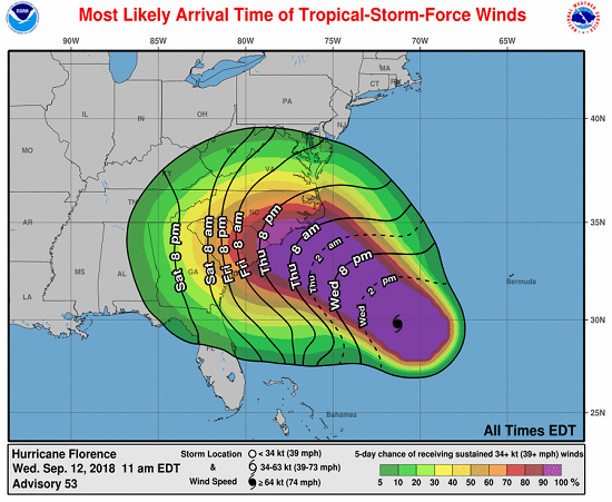
Tropical storm conditions will begin late tonight along the coastal Carolinas with hurricane conditions arriving late tonight and into early tomorrow. Florence may make landfall as a major hurricane (category 3 or higher) Friday morning somewhere near the South and North Carolina border. However, the storm is going to slow considerably and it's possible Florence does not make landfall at all in North Carolina before meandering slowly southeastward towards South Carolina. Regardless of landfall, the fact that Florence is going to slow down and not move directly over land will mean that she will be a strong storm for some time (land interactions with hurricanes typically help to weaken them quickly).
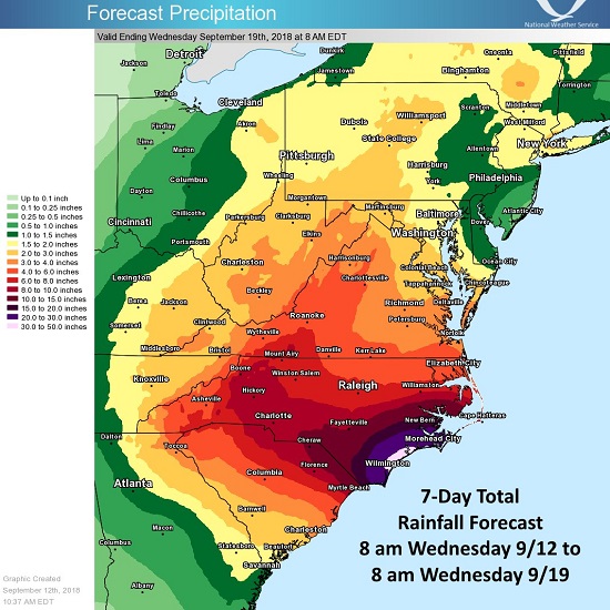
 Widespread +8'' of rain are likely in South Carolina, North Carolina, and possibly even southeastern Georgia. Catastrophic rainfall totals of over 2 feet and maybe even 3 feet are within the realm of possibility closer to the coast on top of a significant storm surge, which will be greater than 9 feet above ground in some areas! This would cause extreme damage anywhere from Charleston, SC to Havelock, NC. While the coast will see the worst of the wind, storm surge, and rain, the flood threat will continue far inland as the storm interacts with the Appalachians resulting in enhanced rainfall.
Likely Catastrophic Impacts
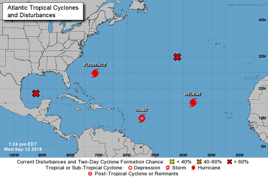 Elsewhere in the Atlantic, we have Tropical Storm Isaac which will move across the Lesser Antilles tomorrow and into the eastern Caribbean Sea tomorrow night. Hurricane Helene is out in the central Atlantic and is expected to turn towards the north and away from the U.S. There could be another system developing over the next few days but it's too early to tell if that would have any impact on the U.S.
Prayers for any and all folks in the path of this monstrous storm. This storm will likely be historic, please heed advice from your local emergency management.
Main messages for Hurricane Florence:- Flooding of historic proportions will occur along coastal sections of the Carolinas and even farther inland
- Hurricane-force winds will bring damage, especially in coastal locations
- Conditions deteriorate in the eastern Carolinas late tonight and likely remain poor through at least Sunday in the Southeast
- This will be a long duration event producing severe flooding even away from the coast; we'll likely be dealing with heavy rain and flooding at least into the early part of next week in the Southeast
- Mandatory evacuations (+1 million people), flooding, and power outages will force store closures, some of which could be closed for an extended amount of time
- Stock outs for storm staples, like bottled water and non-perishable food and generators, are being reported across a wide area of the Carolinas
Tropical storm conditions will begin late tonight along the coastal Carolinas with hurricane conditions arriving late tonight and into early tomorrow. Florence may make landfall as a major hurricane (category 3 or higher) Friday morning somewhere near the South and North Carolina border. However, the storm is going to slow considerably and it's possible Florence does not make landfall at all in North Carolina before meandering slowly southeastward towards South Carolina. Regardless of landfall, the fact that Florence is going to slow down and not move directly over land will mean that she will be a strong storm for some time (land interactions with hurricanes typically help to weaken them quickly).
Widespread +8'' of rain are likely in South Carolina, North Carolina, and possibly even southeastern Georgia. Catastrophic rainfall totals of over 2 feet and maybe even 3 feet are within the realm of possibility closer to the coast on top of a significant storm surge, which will be greater than 9 feet above ground in some areas! This would cause extreme damage anywhere from Charleston, SC to Havelock, NC. While the coast will see the worst of the wind, storm surge, and rain, the flood threat will continue far inland as the storm interacts with the Appalachians resulting in enhanced rainfall.Likely Catastrophic Impacts
- Jacksonville, NC
- Wilmington, NC
- Myrtle Beach, SC
- Charleston, SC
- Raleigh, NC
- Greenville, NC
- Fayetteville, NC
- Charlotte, NC
- Asheville, NC
- Columbia, SC
- Greenville, SC
- Augusta, GA
- Savannah, GA
- Virginia Beach, VA
- Roanoke, VA
- Richmond, VA
- Greensboro, NC
- Athens, GA
- Atlanta, GA
- Macon, GA
Elsewhere in the Atlantic, we have Tropical Storm Isaac which will move across the Lesser Antilles tomorrow and into the eastern Caribbean Sea tomorrow night. Hurricane Helene is out in the central Atlantic and is expected to turn towards the north and away from the U.S. There could be another system developing over the next few days but it's too early to tell if that would have any impact on the U.S.Prayers for any and all folks in the path of this monstrous storm. This storm will likely be historic, please heed advice from your local emergency management.