Recap of the 2017 Atlantic Hurricane Season
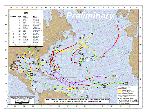
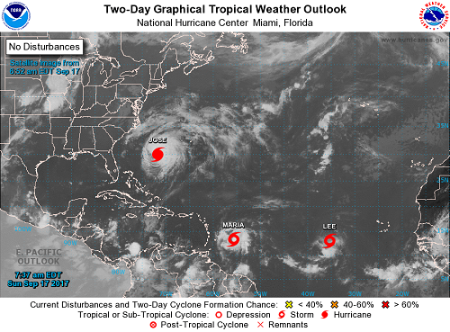
For those in hurricane-prone areas, the 2017 Atlantic Hurricane Season was a season filled with anxiety, loss, devastation, and heartbreak. In total, there were 17 named storms, with 10 hurricanes 6 of which reached major hurricane status. On average, the Atlantic produces about 12 named storms, 6 of which are hurricanes, and 3 of which are major hurricanes, so the season was more active that average. Accumulated Cyclone Energy (ACE), which is a combined measured of strength and duration of tropical storms and hurricanes, was the highest since the busy 2005 season and the 7th highest on record in the Atlantic. The 2017 season got off to an early start in April and activity ended in early November, however, there were several very tense weeks from mid-August to the end of September as Hurricanes Harvey, Irma, Jose, and Maria (among others) battered the U.S. and Caribbean Islands. The map below shows the preliminary track of all 17 storms from the 2017.
-Arlene: On April 19th, the first storm of the season formed, Tropical Storm Arlene. Arlene wasn't a trouble-maker forming far out in the central Atlantic Ocean and only lasting a short time. Arlene was only the second tropical storm on record to form during the month of April.
-Bret: The next storm didn't arrive until mid-June with Tropical Storm Bret forming unusually far south in the Atlantic on June 19th. In fact, Bret was the earliest named storm to form in this region of the Atlantic since record began. Bret brought heavy rain to the southern Caribbean Sea, including Trinidad and Tobago and northern Venezuela.
-Cindy: Tropical Storm Cindy was the first storm of the 2017 to make landfall in the U.S. Cindy formed on June 20th and dissipated June 23rd over the Tennessee Valley. Cindy was the first named tropical system to make landfall in Louisiana since Hurricane Isaac in 2012. Cindy was primarily a rain-maker bringing heavy rain from the Gulf Coast to the Northeast.
-Don: The tropics took a breather from mid-June through mid-July, then Tropical Storm Don formed (July 17th). Don was a short-lived storm that grazed the Windward Islands and caused flash flooding in Trinidad and Tobago.
-Emily: Tropical Storm Emily became the 2nd U.S. land-falling named storm of the 2017 Atlantic Hurricane Season on July 31st. Emily made landfall along Florida's central Gulf Coastline shortly after formation. Emily dissipated by August 1st as she reemerged in the Atlantic off the eastern coast of Florida.
-Franklin: Hurricane Franklin was the first storm to strengthen to hurricane status during the 2017 Atlantic Season. While not a threat to the U.S., Franklin did make landfall as a tropical storm along the Yucatan Peninsula, reemerging in the Bay of Campeche before making a second landfall in eastern Mexico this time as a category 1 hurricane. Franklin dissipated over Mexico soon after landfall on the 10th of August, however, the "ghost" of Franklin helped to spawn Tropical Storm Jova in the eastern Pacific several days later.
-Gert: Hurricane Gert was the 2nd hurricane of the 2017 season, but she did not make landfall although she did produce large waves for the East Coast of the U.S. Gert formed on August 13th and dissipated over the open north Atlantic on the 17th. While Gert did not make landfall as a named storm, the remnants of Gert brought strong winds and heavy rain to the United Kingdom.
- Harvey: Major Hurricane Harvey was the first major hurricane (category 3 or higher) of the 2017 season. Harvey developed into a tropical storm east of the Windward Islands on August 17th. Harvey weakened to a tropical wave after moving into the eastern Caribbean Sea by the 19th. On August 22nd, Harvey's remnants moved across the Yucatan Peninsula and then entered over the very warm weathers of the Bay of Campeche and the western Gulf of Mexico. By the 23rd, Harvey developed into a Tropical Depression and, at this point, most forecasts indicated that Harvey would strengthen into a strong tropical storm or minimal hurricane before making landfall between Brownsville and Houston.
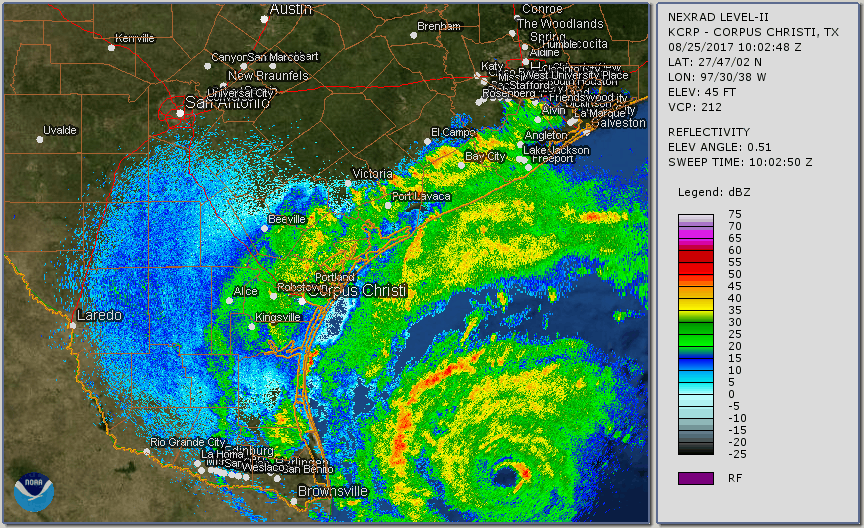
Unfortunately, Harvey had many fooled as he quickly intensified and wound up reaching category 4 status with sustained winds of 130 mph by August 25th. Major Hurricane Harvey made his first landfall on San Jose Island, Texas late on the 25th (the image below is linked to a radar loop showing Harvey's landfall and slow movement over southeast Texas). Harvey was the first major hurricane to strike South Texas since Celia in 1970 and Harvey was the first hurricane to make landfall on the Texas Coast since Ike in 2008. A peak wind gust, according to the National Weather Service, was reported near Port Aransas of 130 mph. Harvey brought strong, damaging winds to Corpus Christi and other surrounding locations.
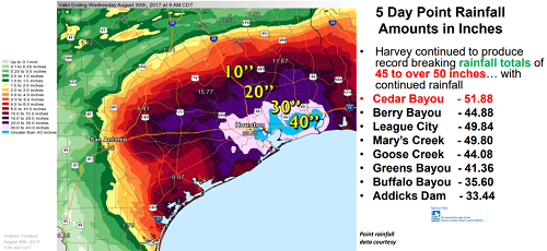
Although wind speeds usually grab the headlines when it comes to tropical storms and hurricanes, rainfall can be just as or more devastating than the wind. Rather than continuing to move farther inland post-landfall, Harvey stalled over southeast Texas for several days dumping tremendous rainfall across the region as a tropical storm. Many rainfall records were broken as over 40'' of rain fell in less than 48 hours. In Cedar Bayou, near Houston, an incredible 51.88'' of rain fell making this the new rainfall record for the continental U.S.! In fact, the National Weather Service had to expand their color legend on their observed precipitation maps to effectively map Harvey's rainfall. Major river flooding occurred throughout southeast Texas.
Harvey made his final landfall near Cameron, Louisiana as a tropical storm on August 30th bringing more heavy rainfall across the northern Gulf Coast. Flooding rain extended up into Arkansas, Kentucky, Mississippi, and Tennessee even after Harvey was downgraded on August 31st.
- Irma: Major Hurricane Irma became the 2nd major hurricane of the 2017 Atlantic Season. Irma formed far out in the Atlantic near the Cape Verde Islands on August 30th. Irma was impressive in that she maintained major hurricane status for nearly a week. At her peak, Irma's maximum sustained winds were a whooping 185 mph in the Atlantic Ocean, which was maintained for over 25 hours, according to the National Weather Service, making this one of the strongest storms on record for the Atlantic basin as well as the longest-lived storm of such intensity anywhere since the satellite era began.
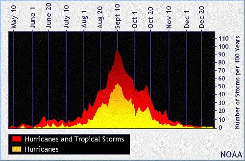
Irma blasted the northeastward Leeward Islands as the eye moved just north of Puerto Rico. Unfortunately, Irma was not the last or most destructive storm to impact the island this season. Irma made her first U.S. mainland landfall with maximum sustained winds of 130 mph (category 4) on September 10th in the Florida Keys, coinciding with the climatological peak of the Atlantic hurricane season (the chart below shows the historical number of storms per 100 years with the peak on September 10th).
Irma made a second landfall on Marco Island, FL with winds of 115 mph (category 3) later the same day. Irma slowly weakened as she headed up along Florida west coast and into north Florida and southwest Georgia into September 11th. Irma finally decayed on September 12th, but was still causing trouble as her extensive wind field and large shield of heavy rain.
-Jose: Major Hurricane Jose was the 3rd major hurricane of the 2017 Atlantic Hurricane Season. Jose formed out in the central Atlantic on September 5th and strengthened to a major hurricane by the 7th. Like Irma, Jose became a very powerful hurricane with maximum sustained winds reaching 155 mph. Jose was a major hurricane as he passed to the north of the Leeward islands. While never making landfall, Jose brought strong winds to the northeastern Leeward Islands and even to coastal New England as he stalled out just south of the New England Coast as a tropical storm on September 21st. Jose dissipated soon thereafter on the 22nd.
-Katia: Hurricane Katia was the 6th hurricane of the 2017 season and she developed in the southwestern Gulf of Mexico on September 5th. Katia made landfall in near Tecolutla, Mexico as a category 1 hurricane, according to the National Hurricane Center.
-Lee: Major Hurricane Lee was the 5th major hurricane of the 2017 season; although he developed before Hurricane Maria, Maria reached major hurricane status before Lee. Thankfully, Lee was a fish storm and didn't make landfall anywhere. Lee developed south of the Cape Verde Islands on the 15th of September and ended up in the central North Atlantic before losing tropical characteristics on the 30th.
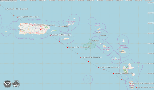
 - Maria: Major Hurricane Maria was the 4th major hurricane of the 2017 season and will be hard to forget. Maria began her fateful journey forming about 700 miles east-southesat of the Lesser Antilles on September 16th. She quickly strengthened into a major hurricane by the 18th and she made her first landfall in Dominica as a beastly category 5 hurricane (the strongest on the Saffir-Simpson scale). Maria was the first category 5 storm in recorded history to make landfall in Dominica. Maria was the 2nd category 5 storm of the 2017 season, the other being Irma, making this only the 6th time that the Atlantic Ocean has had 2 or more category 5 storms in a season. Maria continued charging forward and in the early morning hours of September 20th, made a devastating and historic landfall on Puerto Rico as a category 4 hurricane. Maria then continued north staying off the East Coast of the U.S. and then took a turn to the east, heading out to sea losing her tropical characteristics by the 30th.
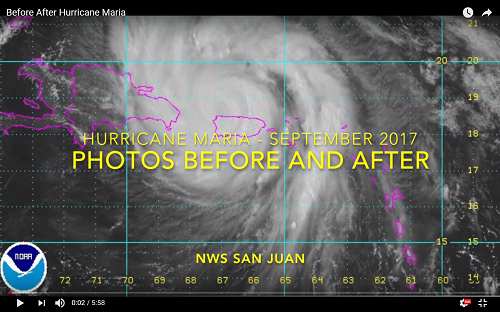
Maria was a "worst-case scenario storm" causing absolute devastation across the Windward Islands, Virgin Islands and Puerto Rico. The region is still reeling from Maria as recovery efforts have been slow as the infrastructure was decimated. Power was knocked out to virtually the entire island of Puerto Rico and basic necessities, such as drinking water, became scarce. The video below, put together by the National Weather Service, shows stunning before and after photos of Maria's destruction.
- Nate: Hurricane Nate formed in the southwestern Caribbean Sea on October 4th. Nate made his first landfall as a tropical storm in Central America on the 5th. He reentered the Caribbean north of Honduras and continued to head north towards the U.S. mainland. Nate strengthened into a hurricane as he moved through the central Gulf of Mexico and then made landfall in Missisippi on the 7th as a category 1 hurricane. Nate caused flooding across the central Gulf Coast, however, the storm was moving at a quick pace so the flooding was no where near severe as the flooding from Harvey who lingered for days. Nate dissipated over the Tennessee Valley on the 9th.
-Ophelia: Major Hurricane Ophelia was the 6th and final major hurricane of the 2017 season. Ophelia formed on October 9th far out in the Atlantic. Ophelia's unusual track into the eastern Atlantic helped to make her the farthest east major hurricane in the Atlantic on record. Ophelia was also the 10th consecutive hurricane on record in the Atlantic, tying a record from over 100 years ago for the number of consecutive hurricanes to form in 1 season. While Ophelia didn't make landfall as a tropical system, post-tropical Ophelia brought very strong winds and heavy rain to Ireland
-Philippe: Tropical Storm Philippe was a short-lived storm that formed in the western Caribbean Sea and made landfall in Cuba before heading north and making landfall in southwestern Florida on October 29th. Philippe brought some heavy rain over Florida and spawned a few tornadoes but overall wasn't severely impactful. Philippe merged with another weather system and lost its tropical characteristics on the 29th.
-Rina: Tropical Storm Rina was the 17th and final named storm of the 2017 Atlantic Hurricane Season. Rina formed far out in the Atlantic on November 6th and dissipated by the 9th. Rina was a fish storm and did not affect any land areas.
The 2017 Atlantic Hurricane Season was one of the busiest and most destructive since the 2005 season when Hurricanes Katrina, Rita, and Wilma made their mark in history. No doubt, there will be several names retired from the National Hurricane Center's list of storm names after this season; storm names are retired when a storm is so deadly or costly that future use of its name would be insensitive. While the season may be over, the storms and their damage are still very fresh on the minds of the large number of people still dealing with the aftermath of the calamitous 2017 Atlantic Hurricane Season.