Spring Weather Outlook Does Not Predict Summer Weather
It's amusing to watch some meteorologists change their Summer forecasts in light of how cool April and May have been and or base the forecast on one climate index (ENSO) but we don't do that here at weathertrends360! It's even more amusing to see how clueless Wall Street is when it comes to weather patterns and ultimate impact on crops. The neat thing about our year-ahead statistical/24 climate cycle approach to long range forecasting allows us to remain confident and NOT CHANGE OUR FORECAST...and yes the statistics predicted the cold April-May (even called out the frost/freeze) so our confidence on the scorching hot/dry Summer 2016 remains very high!
I recall back in middle 2004 when we issued a cold Spring and especially cold May 2005 forecast followed by an epic 2005 hurricane season and scorching hot/dry Summer 2005. One of our big retailers (let's just say they're the biggest company in the world) called us in the middle of the cold May 2015 (it snowed that day in Chicago) and asked a simple question, "are you still confident on your scorching hot/dry Summer and 100% higher demand for Air Conditioner sales"? The answer was an emphatic YES - a mathematical guarantee! Client called all the other retailers if they wanted their excess AC inventory and every one of them was in panic mode due to the cold Spring as they were hearing from meteorologists that Summer was going to be colder than they expected. Ooopppsssss! Four major retailers gave their Summer AC inventory to our client. 3 weeks later the greatest heat-wave in modern history (90s and 100s) raged and continued all Summer long with our client up 100% while the others all stocked out...they made over $130,000,000 on that simple YES!
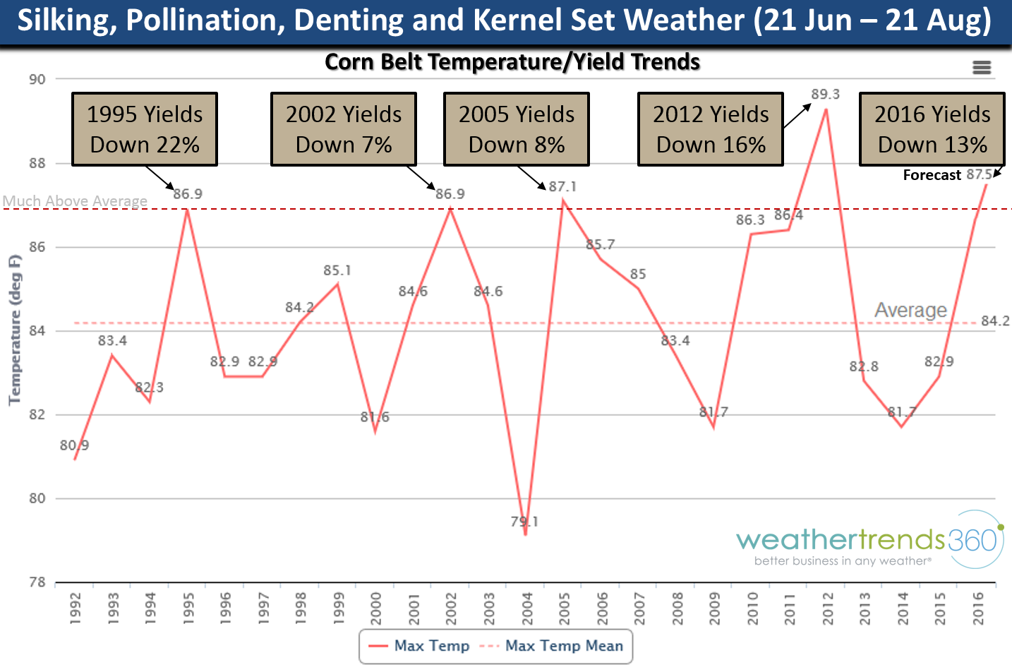
Let's do it again...YES...we are emphatically confident that Summer 2016 is going to bring a scorching hot/dry Summer to much of the Eastern half of the country and especially the Midwest Corn Belt to the Middle Atlantic. Yields will be off 13% from last year and YES prices will go much higher in July-August!
So let's look at some statistics and trends on why we're so confident.
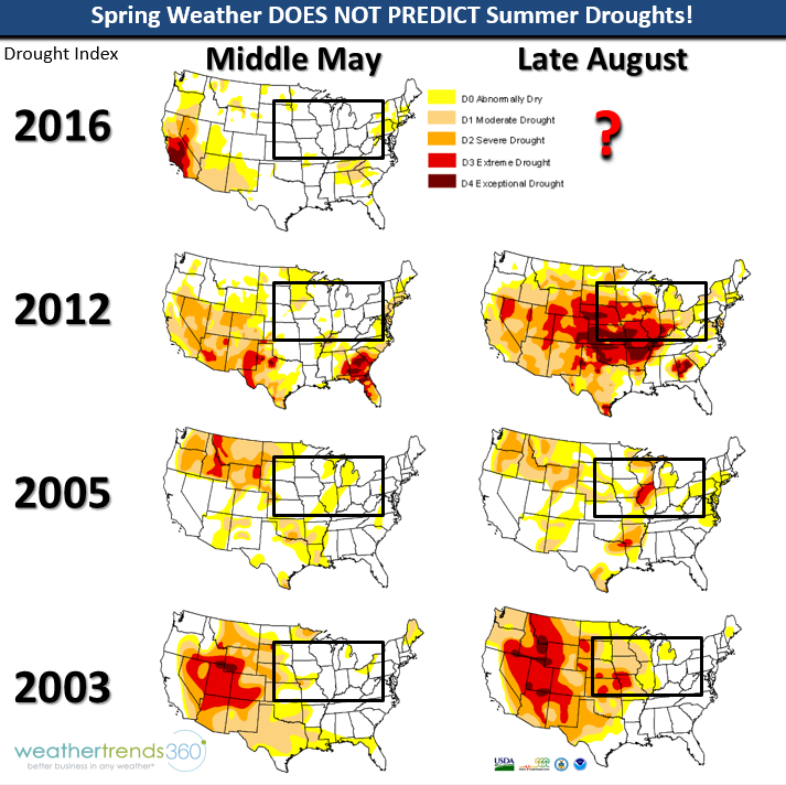
Middle May drought status DOES NOT PREDICT SUMMER DROUGHTS! Looking back at the past few bad crop seasons Spring started off with little if any drought in the Corn Belt but 60-90 days later moderate to severe droughts developed by August. We think this year is a blend between 2012, 2005 and 1995.
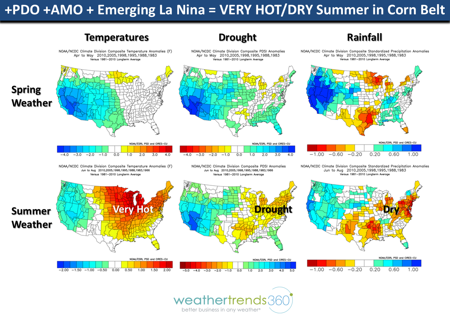
Two of the major 20-30 year oceanic climate cycles ignored by most confirm a 30% to 40% higher than average risk for widespread Summer drought. The Pacific Decadal Oscillation (PDO) cycle is at record levels (#1 warmest of past 121 years) as of April. The other index is the Atlantic Multi-Decadal Oscillation (AMO) cycle and it's a top 9 warmest in 121 years as of April. When both are in their warm phases together the U.S. typically experiences much higher risk for major Summer droughts (see map upper right).

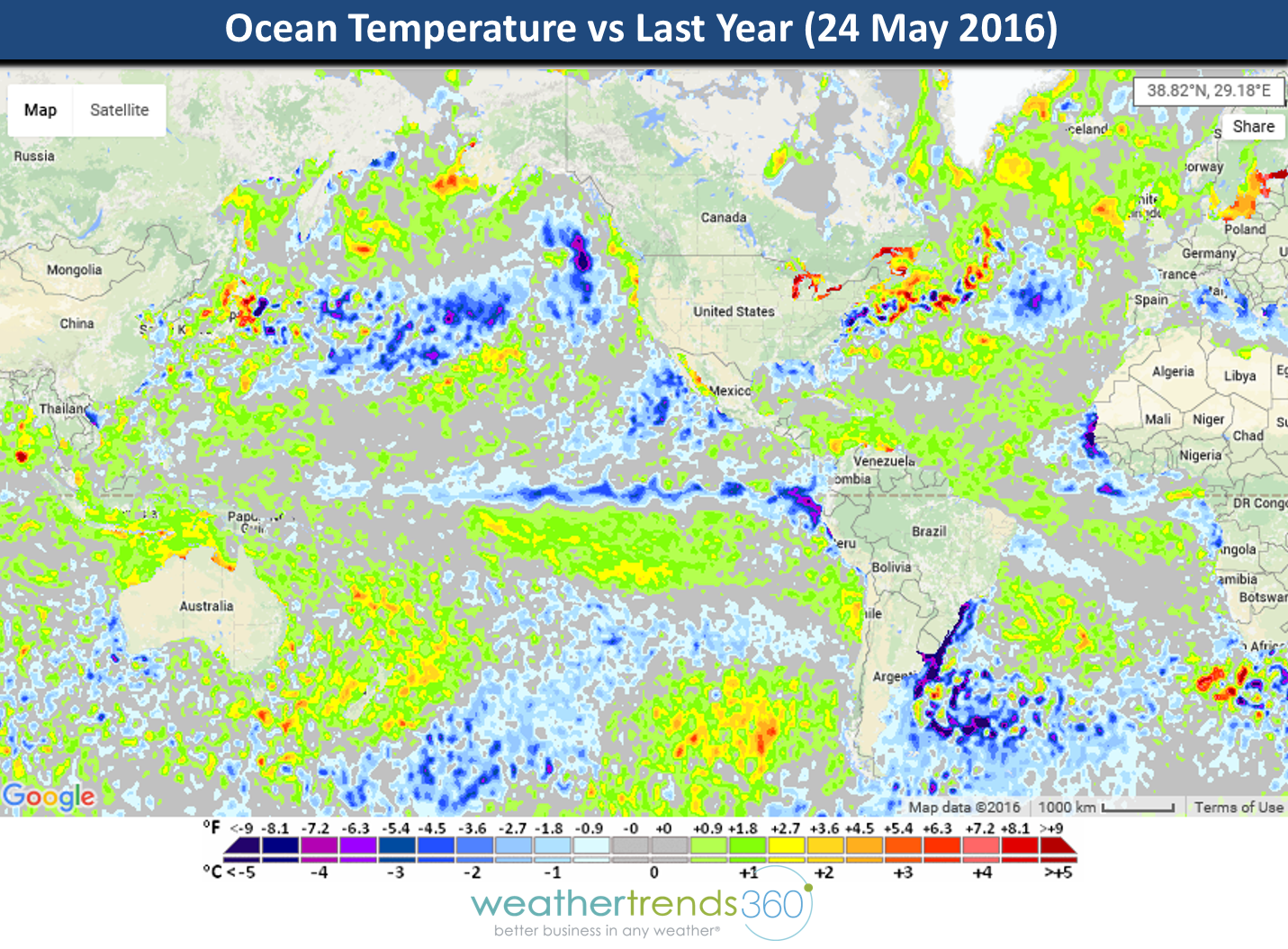
The only index NOAA really uses in making their long term outlooks is ENSO - an El Niño/La Niña cycle. When it's neutral they admit they have no idea. But there missing a big piece of the equation here and that's the CHANGE in the ENSO index and not the absolute value. So, if we look at the change in the Ocean temperatures we can see there is a wholesale pattern shift from a year ago - nothing is even remotely close to last year as we see the plummeting temperatures in the Equatorial Pacific, Much warmer off Australia, much colder in the North Pacific, much colder in the PMM index region off Mexico, etc.
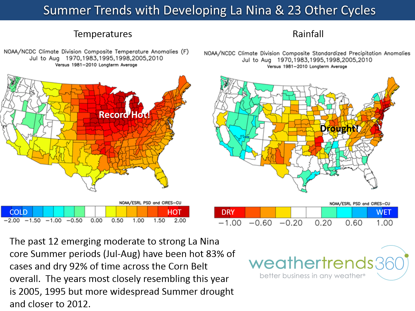
When you compare the current rate of the ENSO index change to prior similar years you get 83% confidence of major heat across much of the U.S. during Summer and 92% confidence on widespread drought.
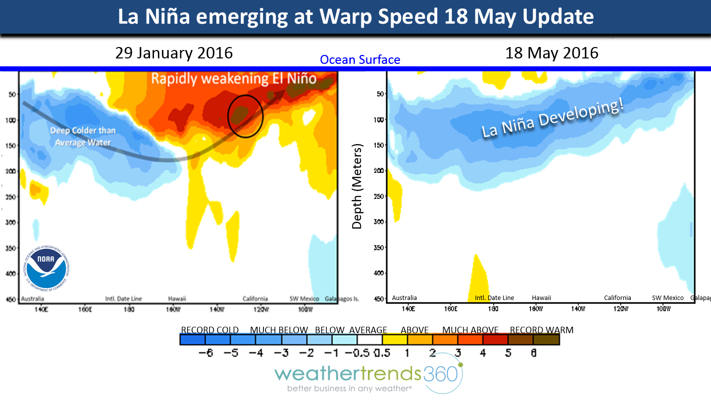
The ENSO sub-surface water temperatures remain very cold (1C TO 5C below average) and this will continue to move to the surface allowing La Niña to approach moderate (-1C below average) to strong levels (-1.5C below average) this Summer with near certainty! The change in ENSO Pacific Ocean temperatures is the greatest in 121 years...that is a critical mistake many meteorologists and NOAA are making.
Interestingly when we line up very strong +PDO, +AMO and emerging La Niña you end up with the kind of spring we just had - cool with normal to above normal rainfall. But look what happens for Summer - an epic change toward scorching heat, drought and dry weather. Trying to assess which exact counties will be hardest hit is borderline impossible but the picture here shows HIGH RISK.
Every farmer knows that the period 45 to 90 days after planting is the most critical period to determine ultimate yields and that window is when we are very concerned for major heat and dry weather. 1995 is a year we think is most representative of this year and that year had excessive Spring rainfall (22% above average and 3rd most in 121 years) only to make a huge flip toward a very hot/dry Summer with yields off 22% from 1994. It's also the last time that both Brazil and the U.S. had bad crop years together - 2016 is that year! The OK spring years in 1995, 2002, 2005, 2012 and now 2016 DID NOT PREDICT THE ULTIMATE HEAT/DROUGHT WITH YIELDS OFF 7% TO 22% just a few months later!
And let's look at July in particular from another perspective since we've had three straight July's with temperatures 1F below average for the Corn Belt as a whole (see chart above). Looking back at the past 121 years there have been three periods (early 1970s, late 1950s and way back in 1904-1906) where there were 3 straight cold July's in a row...but NEVER 4!!! So, another statistic suggesting 100% confidence that July is going to be very hot!!!
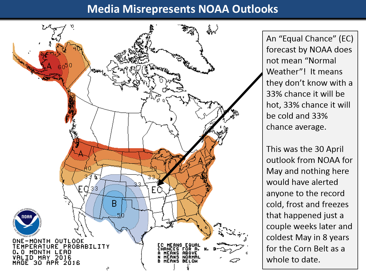
Finally, let's clarify some confusion when looking at NOAA outlooks as Bloomberg News just repeated this common misunderstanding. When you see white on NOAA's outlook where it says EC (Equal Chances) that DOES NOT MEAN NORMAL WEATHER. It actually means they don't know with a 33% chance it's hot, 33% chance its cold and 33% chance its average. In this May 2016 example we see NOAA did well capturing New Mexico cold (50% chance of below avg temps - a high confidence forecast for NOAA) but completely missed the coldest May in 8 years to date in the Corn Belt and Northeast that had major frost/freezes and even snow...very similar to what happened in May 2005!
So, PLEASE prepare for a hot/dry Summer and much higher corn prices - the statistics and climate cycles are very much in your favor if you like higher commodity prices!
Have a great Memorial Day weekend folks. - Capt Kirk out.