Star Date 1 May 2017 Monday
Captain's Log
Happy Monday! Can you believe it's already 1 May???
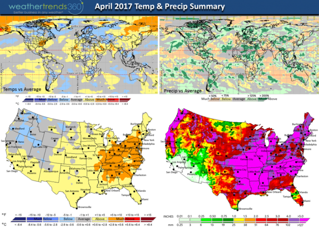
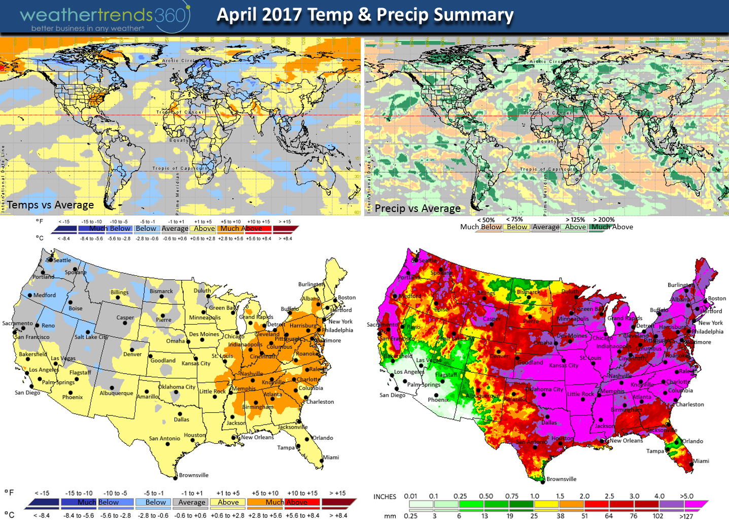
April is in the history books and it was a warm and very wet month. For the U.S. overall it was the warmest in 11 years and #1 wettest in over 26 years. The East was the warm spot, the Northwest the cold spot. The month was full of extremes with wild swings in temperatures from Summer-like to frosty, one suspect Tropical Storm Arlene in the middle of the Atlantic and a fair amount of deadly tornadoes. CLICK ON IMAGES FOR LARGER VIEW
This morning May is coming in like a COLD Lion in the Heartland with SNOW on the back edge of a wrapped up storm system. This is just the first of a series of cold fronts that looks to make the Eastern half of the U.S. quite cold while the West is warm. A flip flop from April.
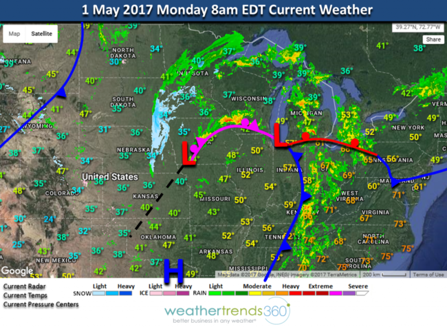
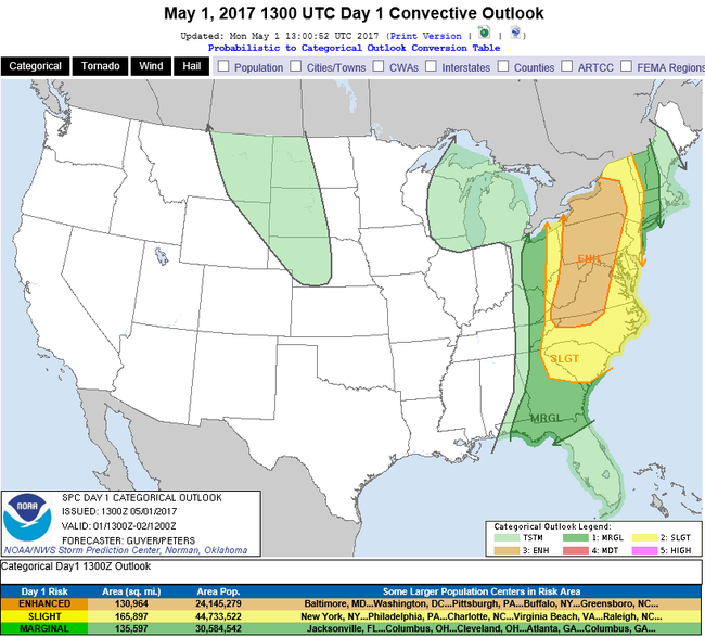
There is also a continued enhanced threat for severe thunderstorms again today along the East Coast - stay safe!!!
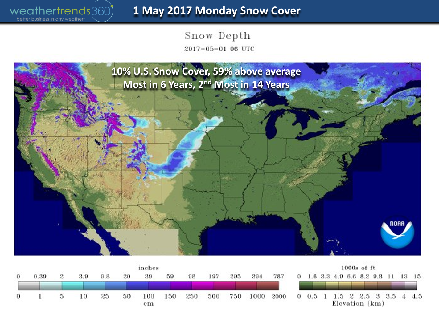
After the weekend snow storm in the Central Rockies, national snow cover is still at 10% which is the 2nd most in 14 years and 59% above average. Even Mauna Kea and Mauna Loa Hawaii had some snow above 13,000 feet of course! We'll add a bit more today in the Upper Midwest.

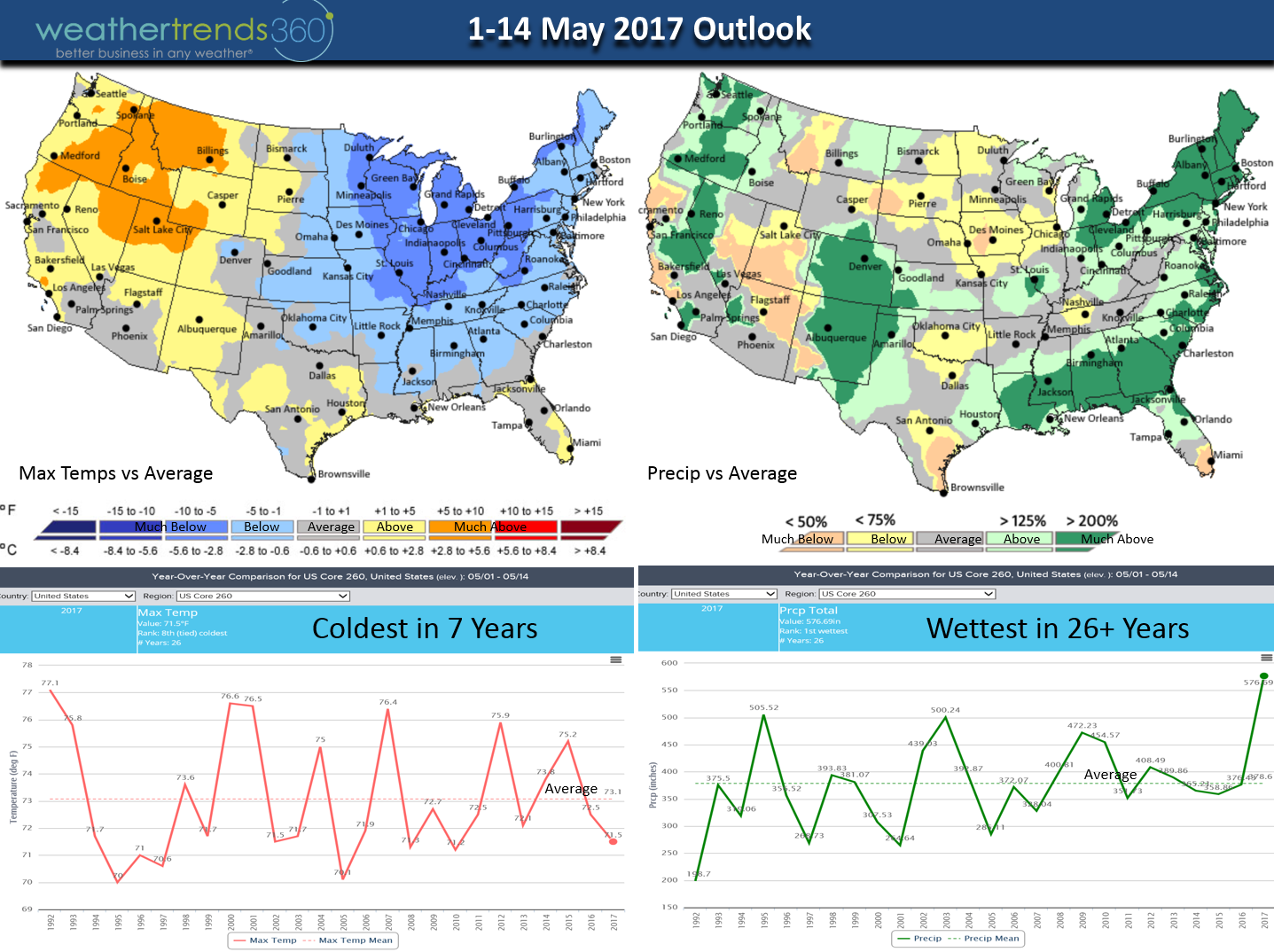
The 2-week outlook shows a cold and very wet pattern for the Eastern U.S. In the Ohio Valley the next two weeks trend the coldest in 20 years, coldest in 26+ years in the Midwest with the frost riskhigh! The U.S. overall trends the coldest start to May in 7 years and wettest in over 26 years. A complete flip flop from April with the Northwest the warm spot...they'll take it after a cold long Winter.

Angelina Kirk enjoyed a somewhat nice weekend tip toeing through the tulips! :) Actually if she sees a Dandelion in the grass she stops to immediately pluck it. Daddy's girl! ha The tulips and flowering trees were especially pretty this year here in Eastern PA.

We hope you have a great week and visit us on Facebook and Twitter for daily updates.
- Capt Kirk out.
April is in the history books and it was a warm and very wet month. For the U.S. overall it was the warmest in 11 years and #1 wettest in over 26 years. The East was the warm spot, the Northwest the cold spot. The month was full of extremes with wild swings in temperatures from Summer-like to frosty, one suspect Tropical Storm Arlene in the middle of the Atlantic and a fair amount of deadly tornadoes. CLICK ON IMAGES FOR LARGER VIEW
This morning May is coming in like a COLD Lion in the Heartland with SNOW on the back edge of a wrapped up storm system. This is just the first of a series of cold fronts that looks to make the Eastern half of the U.S. quite cold while the West is warm. A flip flop from April.

There is also a continued enhanced threat for severe thunderstorms again today along the East Coast - stay safe!!!

After the weekend snow storm in the Central Rockies, national snow cover is still at 10% which is the 2nd most in 14 years and 59% above average. Even Mauna Kea and Mauna Loa Hawaii had some snow above 13,000 feet of course! We'll add a bit more today in the Upper Midwest.
The 2-week outlook shows a cold and very wet pattern for the Eastern U.S. In the Ohio Valley the next two weeks trend the coldest in 20 years, coldest in 26+ years in the Midwest with the frost riskhigh! The U.S. overall trends the coldest start to May in 7 years and wettest in over 26 years. A complete flip flop from April with the Northwest the warm spot...they'll take it after a cold long Winter.
Angelina Kirk enjoyed a somewhat nice weekend tip toeing through the tulips! :) Actually if she sees a Dandelion in the grass she stops to immediately pluck it. Daddy's girl! ha The tulips and flowering trees were especially pretty this year here in Eastern PA.

We hope you have a great week and visit us on Facebook and Twitter for daily updates.
- Capt Kirk out.