Star Date 10 January 2019 Thursday Update
Captain's Log
10 Jan Thursday Update: A quick update on the weekend snow storm traversing the U.S. and then we gear up for another bigger snow storm threat for the following weekend (19th-20th). Have a great weekend.
7 Jan 2019 Good morning...happy Monday! :)
Finally starting to see the weather pattern break down a bit as we enter a more favorable phase for cold and snow to return to the Great Lakes, Northeast. CLICK ON IMAGES FOR A LARGER VIEW.

This week (7-13 Jan) shows the colder trends along the East Coast as we enter MJO cycle phase 8 which usually is colder and snowier for the East Coast.
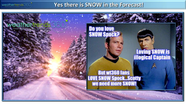 Snow lovers in the Northeast will hopefully get their wish this week into next weekend...Spock would argue that loving snow is illogical but the 60,000 some wt360 fans on Facebook...LOVE SNOW! We also remind folks that are writing off Winter that we're only 18% into Winter...that means we have 82% to go so hang in there cold/snow lovers.
Also seeing signs that the weak El Nino is beginning to act like it should with the very heavy rain pattern along the Deep South, especially Texas where flooding could become an issue over the next couple weeks. Heavy rain also likely for the West Coast. For the U.S. as a whole the week looks to trend cooler than last year, 12th warmest of the past 30 years, a bit drier than last year but still 6th wettest of the past 30 and most snow in 8 years for the U.S. overall.
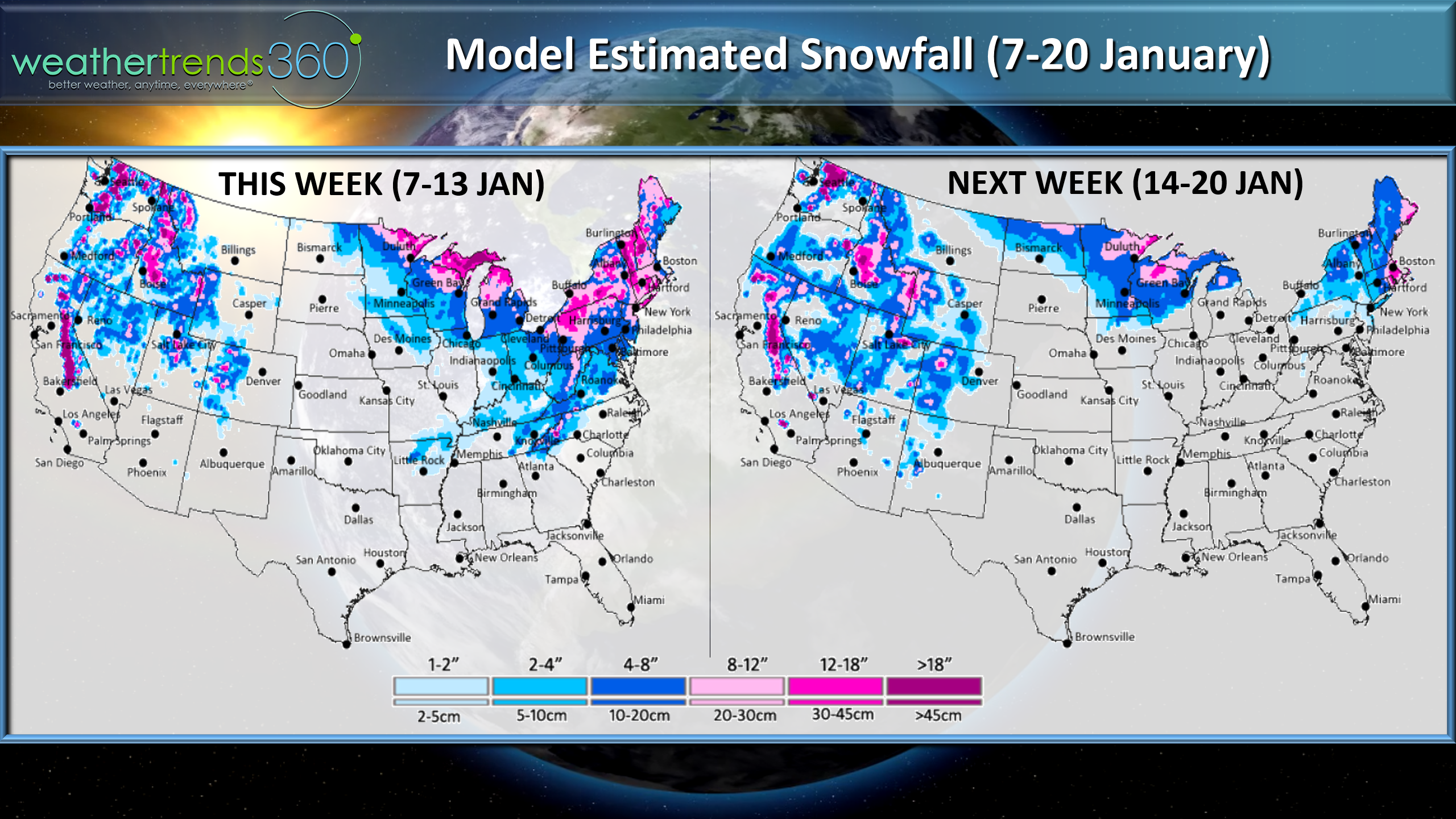
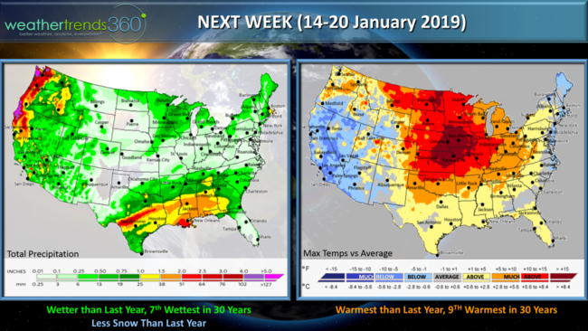 Next week (14-20 Jan) The MJO cycle phase 8 looks to go into phases 1 and 2 which is also cold along the East Coast so it may not be as warm as depicted here. From there the MJO cycle may become a non-player along other cycles to finally dominate the U.S. weather pattern as they normally do (PNA, NAO, AO, EPO, etc.). For the U.S. overall the week looks to trend warmer than last year and 9th warmest in 30 years but this may be a bit overdone, wetter than last year, 7th wettest of the past 30 with less snow than last year. More Northeast snow threats are possible 18th, 20th, 23rd so we'll need to watch for a pretty epic pattern shift as statistics and cycles all strongly suggest Winter should become brutal for a 4-6 week stretch.

El Nino is borderline weak which typically favors warm west and cold/snowy East and that should start to materialize as the models are hinting.
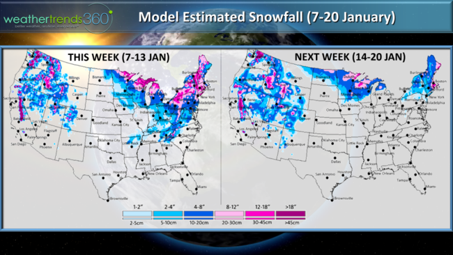
The 2-week modeled snowfall outlook shows the bigger threats in the Great Lakes and Northeast and even the Middle Atlantic could get some snow with the potential coastal storm around the 12th-13th.
8-day snowfall forecast animation.

Finally, the little one turned 3 this past weekend and if you don't know who Blippi is...you so don't have a 3-year old! ;)
Have a great week folks and follow us on social media for frequent updates.Facebook,Twitter,YouTube,PinterestandLinkedin
- Captain Kirk out.
7 Jan 2019 Good morning...happy Monday! :)
Finally starting to see the weather pattern break down a bit as we enter a more favorable phase for cold and snow to return to the Great Lakes, Northeast. CLICK ON IMAGES FOR A LARGER VIEW.

This week (7-13 Jan) shows the colder trends along the East Coast as we enter MJO cycle phase 8 which usually is colder and snowier for the East Coast.
 Snow lovers in the Northeast will hopefully get their wish this week into next weekend...Spock would argue that loving snow is illogical but the 60,000 some wt360 fans on Facebook...LOVE SNOW! We also remind folks that are writing off Winter that we're only 18% into Winter...that means we have 82% to go so hang in there cold/snow lovers.
Also seeing signs that the weak El Nino is beginning to act like it should with the very heavy rain pattern along the Deep South, especially Texas where flooding could become an issue over the next couple weeks. Heavy rain also likely for the West Coast. For the U.S. as a whole the week looks to trend cooler than last year, 12th warmest of the past 30 years, a bit drier than last year but still 6th wettest of the past 30 and most snow in 8 years for the U.S. overall.
 Next week (14-20 Jan) The MJO cycle phase 8 looks to go into phases 1 and 2 which is also cold along the East Coast so it may not be as warm as depicted here. From there the MJO cycle may become a non-player along other cycles to finally dominate the U.S. weather pattern as they normally do (PNA, NAO, AO, EPO, etc.). For the U.S. overall the week looks to trend warmer than last year and 9th warmest in 30 years but this may be a bit overdone, wetter than last year, 7th wettest of the past 30 with less snow than last year. More Northeast snow threats are possible 18th, 20th, 23rd so we'll need to watch for a pretty epic pattern shift as statistics and cycles all strongly suggest Winter should become brutal for a 4-6 week stretch.
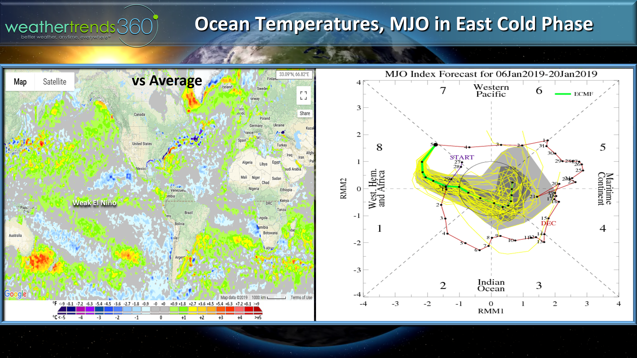
El Nino is borderline weak which typically favors warm west and cold/snowy East and that should start to materialize as the models are hinting.
The 2-week modeled snowfall outlook shows the bigger threats in the Great Lakes and Northeast and even the Middle Atlantic could get some snow with the potential coastal storm around the 12th-13th.
8-day snowfall forecast animation.

Finally, the little one turned 3 this past weekend and if you don't know who Blippi is...you so don't have a 3-year old! ;)
Have a great week folks and follow us on social media for frequent updates.Facebook,Twitter,YouTube,PinterestandLinkedin
- Captain Kirk out.