Star Date 17 April 2017 Monday
Captain's Log
We hope you had a wonderful Easter weekend!
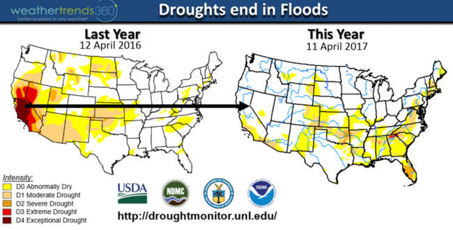
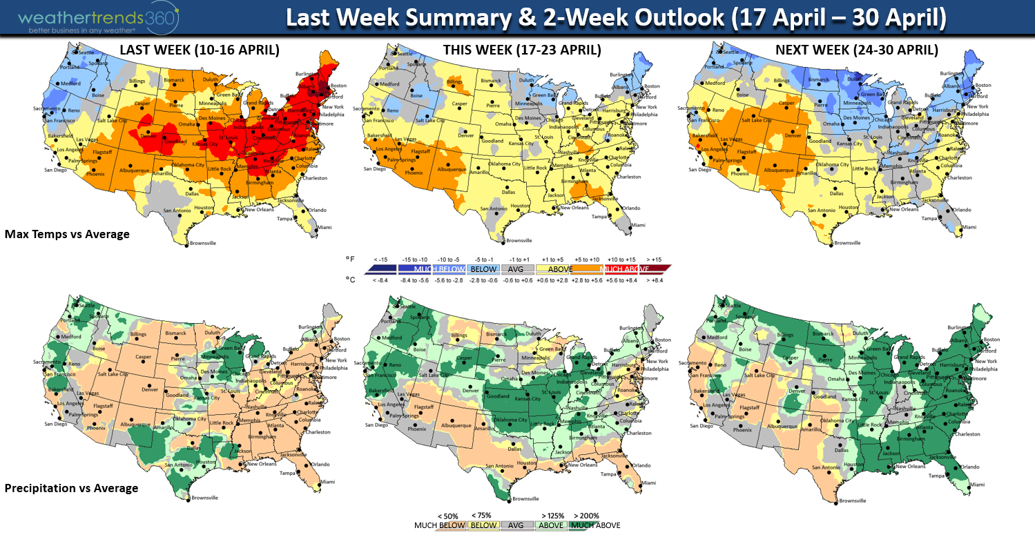
LAST WEEK (10-16 April) was on the warm side for the U.S. overall trending warmest in 11 years and driest in 7 years (35% below average rainfall). But it was announced that Northern California has officially set a record wet Winter with 90" of liquid equivalent breaking the old record of 88.5" set in 1982-1983. A typical year is 50". Translate that into snow and it's also pretty epic with 685" at Kirkwood Mountain and 612" at Lake Tahoe. Flooding has already been a problem with damage estimated at $1 billion.
THIS WEEK (17-23 April) is a tad cooler but still 5th warmest of the past 26 years for the U.S. overall, but don't expect 80s anytime soon again across the Northeast. Storminess also increases with national rainfall expected to be 4th wettest of the past 26 years and wettest in 4 years. CLICK ON ANY IMAGE FOR LARGER VIEW
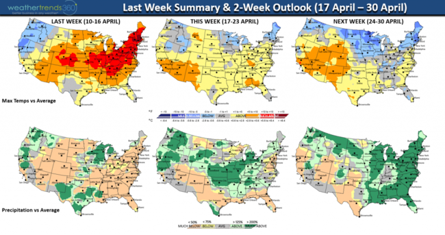
NEXT WEEK (24-30 April) gets even a tad cooler with the anomalies for the northern tier of the U.S. with even a few significant but short-lived cold shots into the South Central U.S. These cold fronts likely to be accompanied by rounds of severe thunderstorms.
Comparing the drought monitor this year to last year shows the dramatic improvement for California with water restrictions lifted!
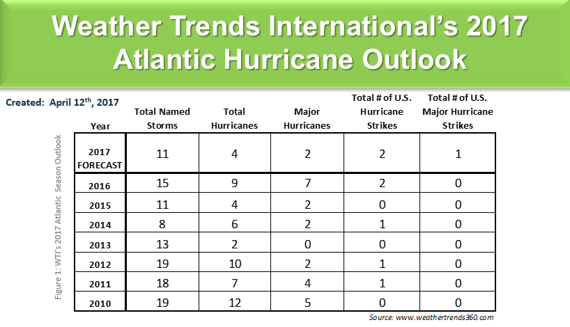
A drought of a different kinds still exists in the U.S. and that's the 11.5years without a major land falling hurricane in the U.S. This is a record long streak of at least 166 years since NOAA data started. The previous record long streak without a major landfalling hurricane was back in 1860-1869. We came very close last year with Hurricane Matthew (became a category 5) in the Southeast but it was only a Cat 1 at landfall in McClellansville S.C. despite the epic flooding in the Carolina's. But, it doesn't take a major hurricane to create epic problems if it hits a populated area as Hurricane Sandy (cat 1) proved 29 Oct 2012 with $50 billion in damages. The last major (cat 3) hurricane to strike the U.S. was Wilma back on 24 Oct 2005.
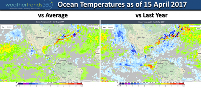
We are likely entering a weak El Niño Summer and those tend to suppress activity in the Atlantic Basin. But, not all El Niño's are the same and we saw firsthand with this weak La Niña Winter that California got a ton of rain/snow in a pattern that doesn't typically bring that much rain. And it only takes one big land falling hurricane in an otherwise weak season to make it a bad year. Ocean temperatures are warmer than average in the Equatorial Pacific Ocean but still trending cooler than last year so we're still really under weak La Niña type conditions.
Our highest risk area is the Northwest Gulf of Mexico as water temperatures are well above average. Frequent cool fronts in the Northeast this Summer likely to provide some protection for any major impacts from Virginia to Maine. It's still likely to be a very wet year in the Northeast after a pretty bad drought last year.
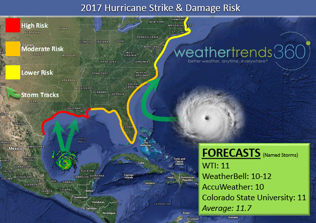
Stronger systems would be more likely to develop in the Gulf or W. Caribbean as opposed to the late season Cape Verde storms that come off Africa as those are more likely to encounter upper level wind shear as El Niño peaks in the Summer. Anothercontributing factor is the cooler Atlantic basin in the MDR region where many systems form. Overall, the tropical pattern most closely resembles 1957 and 2002. Most weather firms and government agencies/academics are forecasting a below average season - rare consensus. So, will the major hurricane drought end in 2017? TBD!

We hope you have a great week folks! - Capt Kirk out.
LAST WEEK (10-16 April) was on the warm side for the U.S. overall trending warmest in 11 years and driest in 7 years (35% below average rainfall). But it was announced that Northern California has officially set a record wet Winter with 90" of liquid equivalent breaking the old record of 88.5" set in 1982-1983. A typical year is 50". Translate that into snow and it's also pretty epic with 685" at Kirkwood Mountain and 612" at Lake Tahoe. Flooding has already been a problem with damage estimated at $1 billion.
THIS WEEK (17-23 April) is a tad cooler but still 5th warmest of the past 26 years for the U.S. overall, but don't expect 80s anytime soon again across the Northeast. Storminess also increases with national rainfall expected to be 4th wettest of the past 26 years and wettest in 4 years. CLICK ON ANY IMAGE FOR LARGER VIEW
NEXT WEEK (24-30 April) gets even a tad cooler with the anomalies for the northern tier of the U.S. with even a few significant but short-lived cold shots into the South Central U.S. These cold fronts likely to be accompanied by rounds of severe thunderstorms.
Comparing the drought monitor this year to last year shows the dramatic improvement for California with water restrictions lifted!

A drought of a different kinds still exists in the U.S. and that's the 11.5years without a major land falling hurricane in the U.S. This is a record long streak of at least 166 years since NOAA data started. The previous record long streak without a major landfalling hurricane was back in 1860-1869. We came very close last year with Hurricane Matthew (became a category 5) in the Southeast but it was only a Cat 1 at landfall in McClellansville S.C. despite the epic flooding in the Carolina's. But, it doesn't take a major hurricane to create epic problems if it hits a populated area as Hurricane Sandy (cat 1) proved 29 Oct 2012 with $50 billion in damages. The last major (cat 3) hurricane to strike the U.S. was Wilma back on 24 Oct 2005.
We are likely entering a weak El Niño Summer and those tend to suppress activity in the Atlantic Basin. But, not all El Niño's are the same and we saw firsthand with this weak La Niña Winter that California got a ton of rain/snow in a pattern that doesn't typically bring that much rain. And it only takes one big land falling hurricane in an otherwise weak season to make it a bad year. Ocean temperatures are warmer than average in the Equatorial Pacific Ocean but still trending cooler than last year so we're still really under weak La Niña type conditions.
Our highest risk area is the Northwest Gulf of Mexico as water temperatures are well above average. Frequent cool fronts in the Northeast this Summer likely to provide some protection for any major impacts from Virginia to Maine. It's still likely to be a very wet year in the Northeast after a pretty bad drought last year.

Stronger systems would be more likely to develop in the Gulf or W. Caribbean as opposed to the late season Cape Verde storms that come off Africa as those are more likely to encounter upper level wind shear as El Niño peaks in the Summer. Anothercontributing factor is the cooler Atlantic basin in the MDR region where many systems form. Overall, the tropical pattern most closely resembles 1957 and 2002. Most weather firms and government agencies/academics are forecasting a below average season - rare consensus. So, will the major hurricane drought end in 2017? TBD!
We hope you have a great week folks! - Capt Kirk out.