Star Date: 18 August 2016 Thursday
Captain's Log
Happy Thursday folks...we can see the weekend from here! :)
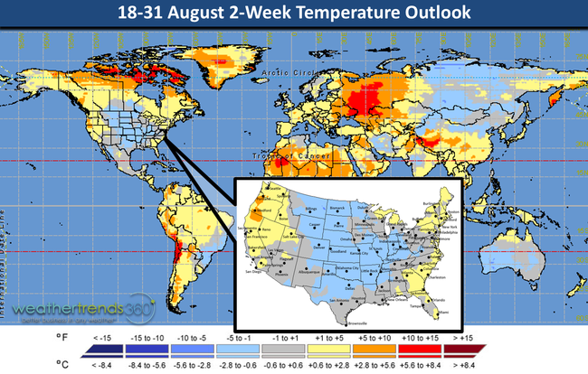
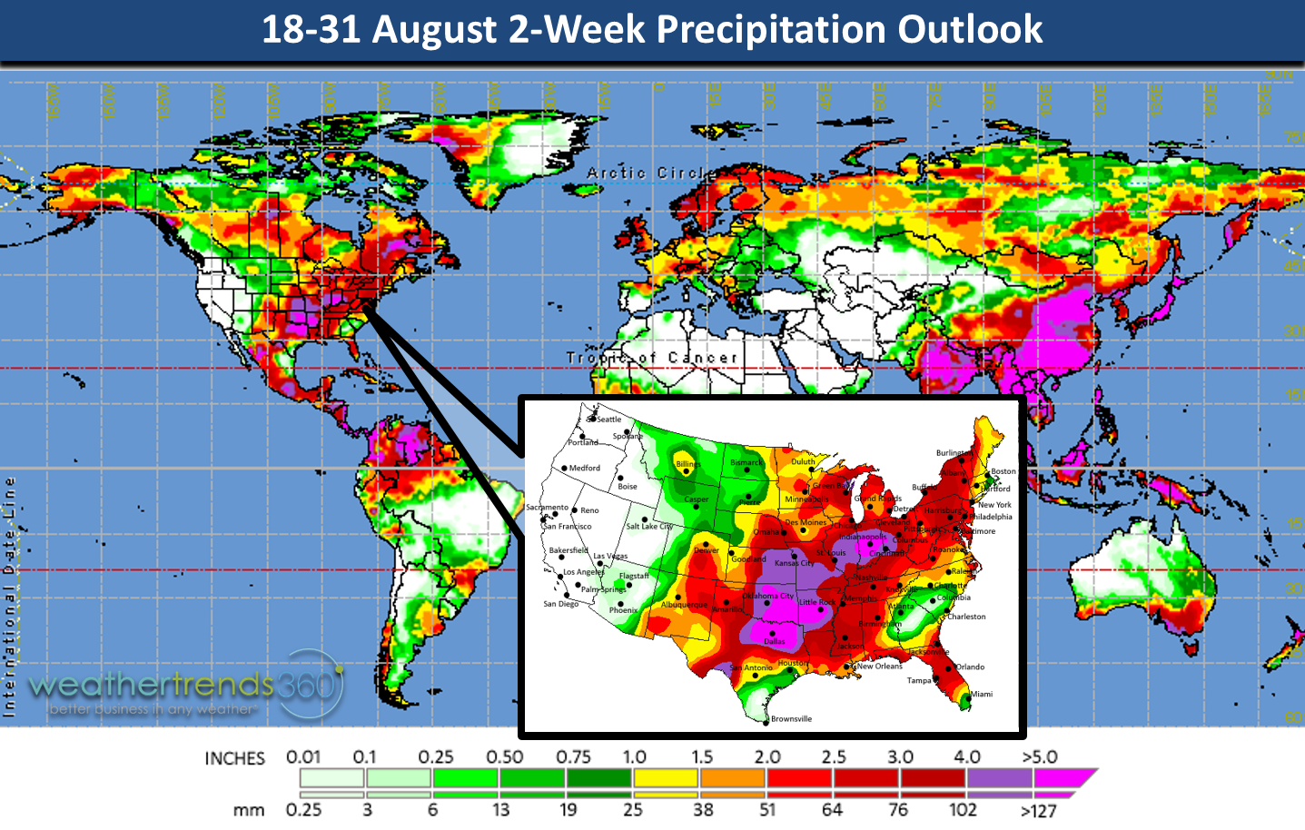
The last 2 weeks of August are flip-flopping a bit from the 3rd hottest front half of August (1st - 17th) in 121 years and hottest in 6 years for the nation as a whole to the coolest in 7 years for the 18-31 period. National rainfall was excessive ranking #1 wettest in 25+ years (31% above average nationally) the beginning of the month (1st - 17th) and that #1 wet continues for these last 2 weeks. The other really wet spot in the World is China where they continue to have record rainfall. China August rainfall looks to be a whopping 90% above average for the country which is a wholesale change from the prior 5 years when August rainfall was below average. Last year August they were 8% below average so a huge change and classic La Nina signature going from dry to record wet across Asia.

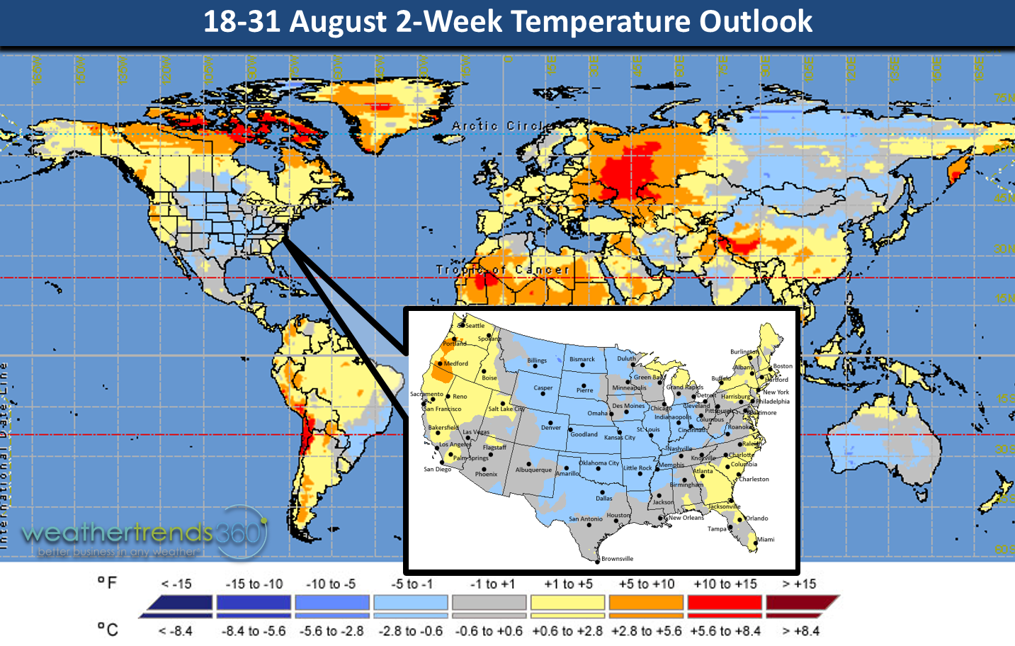
World temperatures the next two weeks show the predominant cooler pattern in the U.S. while Eastern Europe is quite hot. We'll take some cool in the U.S. as meteorological Summer to date (1 June - 18 August) has been the 2nd hottest in 121 years and just 0.1F shy of 2012's record hot Summer. National Summer rainfall has been the driest in 4 years and 3% below average but it's been feast or famine for many.
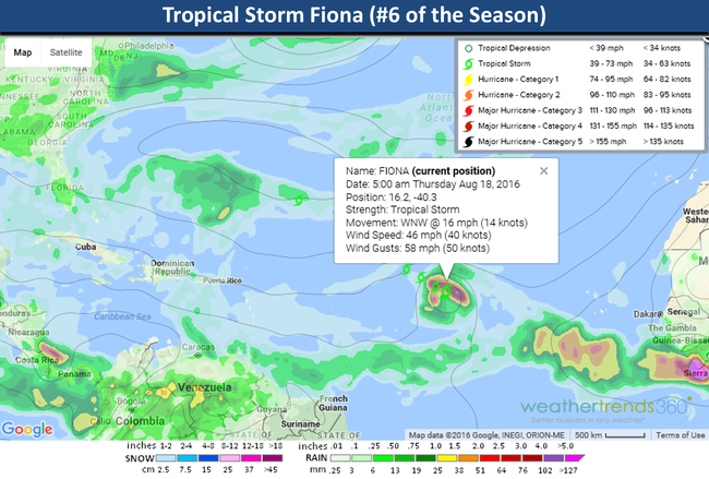
The 6th named storm of the Atlantic Hurricane season (FIONA) has formed but appears she will remain a fish storm and stay out to sea. Very likely we get GASTON next week with a similar path off Africa into the open Atlantic Ocean. So, the tropics are heating up and worth watching as we head toward the peak months of Sep-Oct. The active pace is more similar to 2011, 2008 and 2005 and those seasons averaged 17-28 named systems so clearly we're headed for an above average season and that increases the risk for U.S. land-falling storms/hurricanes in the weeks and months ahead.
Hope you have a great weekend folks! - Capt Kirk out.
The last 2 weeks of August are flip-flopping a bit from the 3rd hottest front half of August (1st - 17th) in 121 years and hottest in 6 years for the nation as a whole to the coolest in 7 years for the 18-31 period. National rainfall was excessive ranking #1 wettest in 25+ years (31% above average nationally) the beginning of the month (1st - 17th) and that #1 wet continues for these last 2 weeks. The other really wet spot in the World is China where they continue to have record rainfall. China August rainfall looks to be a whopping 90% above average for the country which is a wholesale change from the prior 5 years when August rainfall was below average. Last year August they were 8% below average so a huge change and classic La Nina signature going from dry to record wet across Asia.
World temperatures the next two weeks show the predominant cooler pattern in the U.S. while Eastern Europe is quite hot. We'll take some cool in the U.S. as meteorological Summer to date (1 June - 18 August) has been the 2nd hottest in 121 years and just 0.1F shy of 2012's record hot Summer. National Summer rainfall has been the driest in 4 years and 3% below average but it's been feast or famine for many.
The 6th named storm of the Atlantic Hurricane season (FIONA) has formed but appears she will remain a fish storm and stay out to sea. Very likely we get GASTON next week with a similar path off Africa into the open Atlantic Ocean. So, the tropics are heating up and worth watching as we head toward the peak months of Sep-Oct. The active pace is more similar to 2011, 2008 and 2005 and those seasons averaged 17-28 named systems so clearly we're headed for an above average season and that increases the risk for U.S. land-falling storms/hurricanes in the weeks and months ahead.

Hope you have a great weekend folks! - Capt Kirk out.