Star Date: 18 December 2017 Monday
Captain's Log
Happy Monday! :)
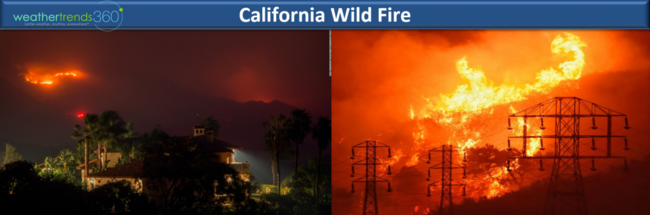
A week until Christmas...YIKES! After a week of cold and several snow events in the East, temperatures will moderate until the next Arctic blast begins to invade the U.S. late this week. The Santa Barbara area of Southern California continues to battle a huge wild fire (The Thomas Fire) that is now threatening million dollar neighborhoods. Some onshore Westerly wind flow the next 2-days will help with higher humidity but the fire is still only 45% contained and Santa Winds could return midweek into the weekend. CLICK ON IMAGES FOR LARGER VIEW
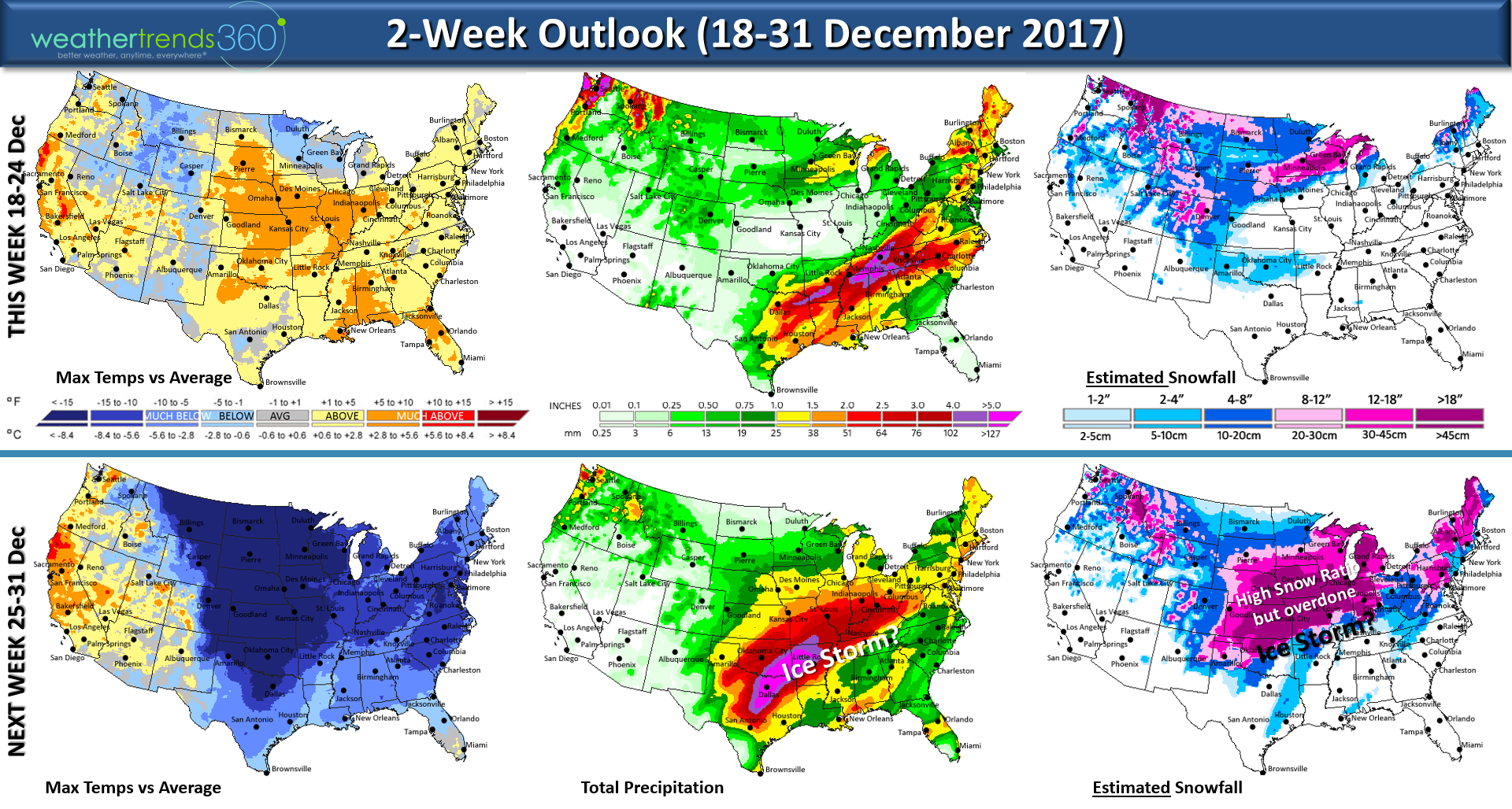
A major Arctic blast will impact 2/3rds of the U.S. late this week into Christmas week with several bigger snow storm threats. The first cold front sweeps through the Northeast briefly on Thursday but a storm tracking through the Midwest/Great Lakes will allow a warm front to return to the East Coast.
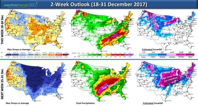
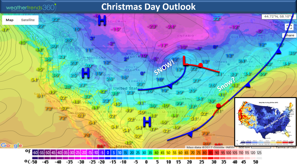
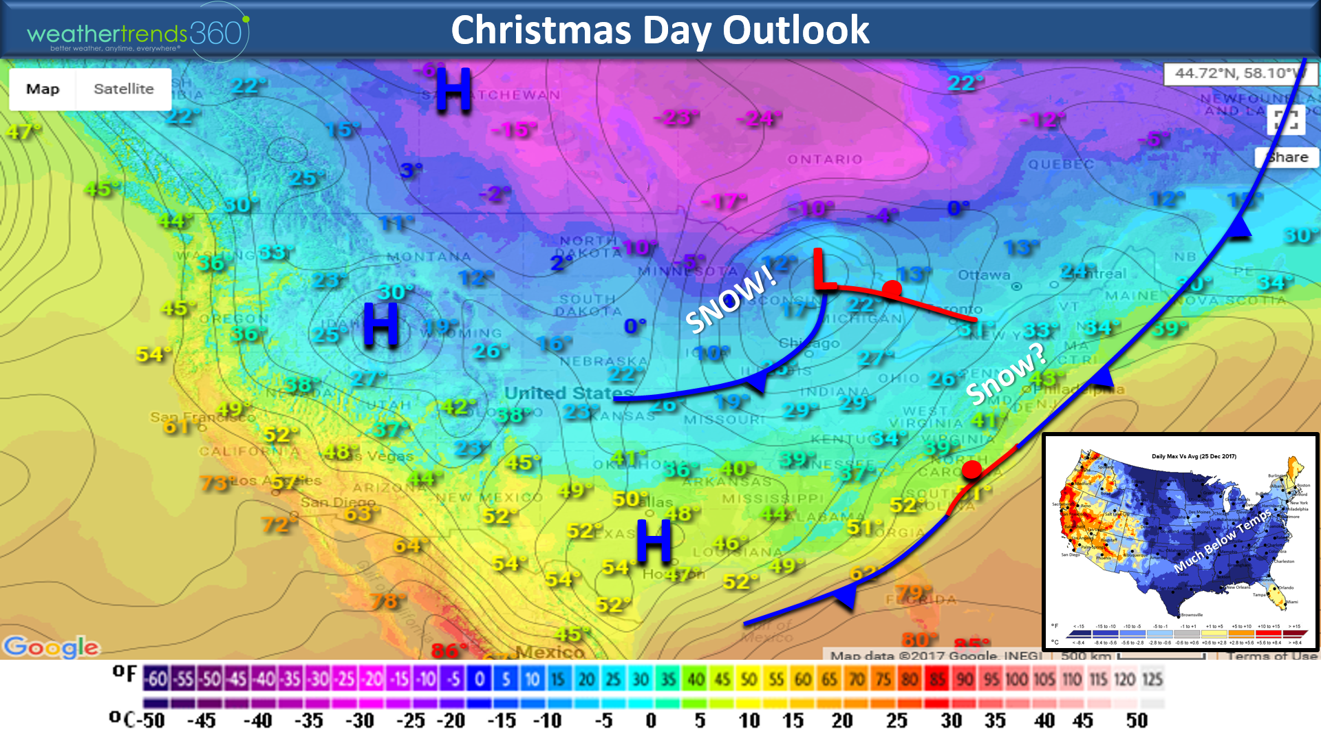
The main chunk of brutally cold air will begin to invade the Upper Midwest/Plains Friday, the South Central into Texas Saturday and off the East Coast Christmas Eve (Sunday). The front will likely stall just off the U.S. East Coast so this sets up the potential for some wintry precipitation Christmas Day in the Northeast. A strong reinforcing shot of very cold air will accompany a Clipper moving through the Great Lakes Christmas Day. The U.S. GFS has been struggling with this pattern as it tries to push Arctic air into the Southwest and that just doesn't happen under this weather pattern. It has been slowly correcting bringing the colder weather in early this weekend but it may be a few more days until we know for sure how much if any snow falls Christmas Day in the East. The Northeast will have high temps in the 20s and 30s inland, low 40s near the cost so not upper 60s this year!
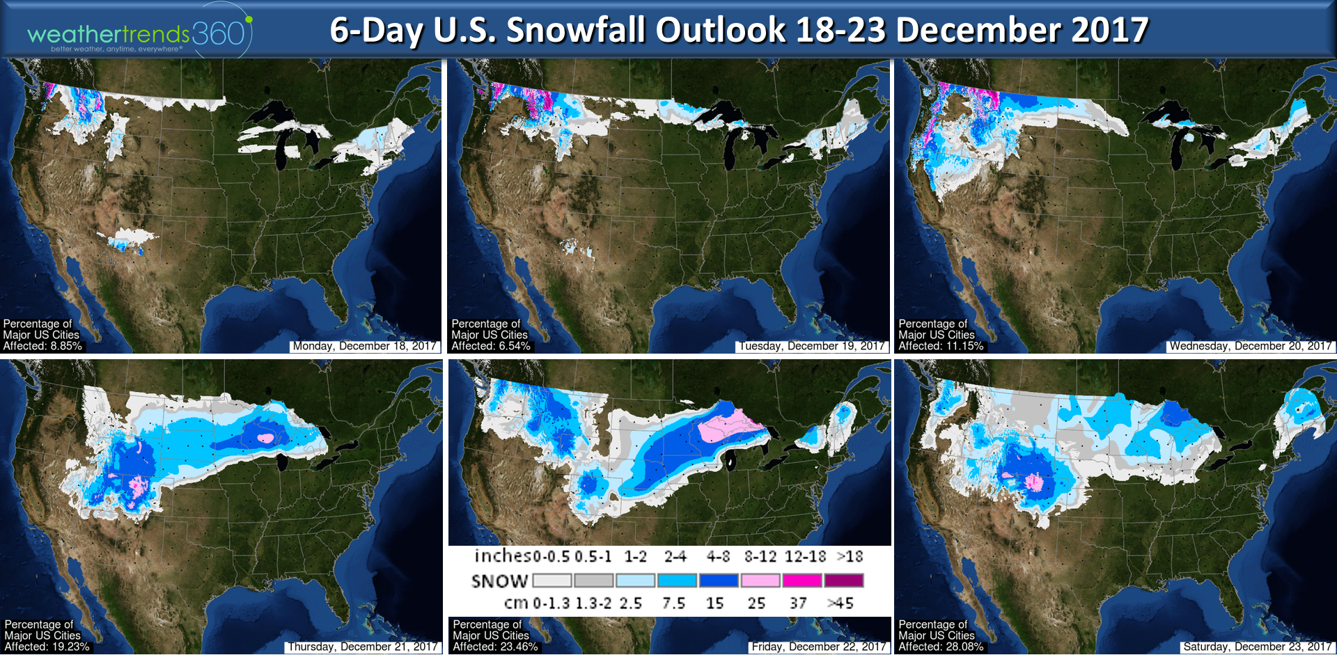
6-Day snowfall outlook below.

Then there's the potential for a major ice storm and snow storm impacting much of the Eastern half of the U.S. the 28th-31st so if you have travel plans after Christmas, you could have some major travel headaches. The week 2 snowfall map above is a bit over done but with brutally cold air in place the liquid snow ratios will be very high so the potential does exist for a major snow storm and ice storm impacting dozens of states. Keep you posted.
For December overall it looks like the Eastern half of the U.S. will end up the coldest and snowiest in 7 years while the Western half is the warmest in 3 years with the least snowfall in 11 years. Snowy December in the Northeast bring 86% odds that the rest of the Winter will be cold and snowy with much above average snowfall so this is just the start of a pretty bad winter in the Lakes-Northeast.
We hope you have a great week and travel safe if you're getting an early start. Follow us on Facebook and Twitter for daily updates.
- Captain Kirk out.
A week until Christmas...YIKES! After a week of cold and several snow events in the East, temperatures will moderate until the next Arctic blast begins to invade the U.S. late this week. The Santa Barbara area of Southern California continues to battle a huge wild fire (The Thomas Fire) that is now threatening million dollar neighborhoods. Some onshore Westerly wind flow the next 2-days will help with higher humidity but the fire is still only 45% contained and Santa Winds could return midweek into the weekend. CLICK ON IMAGES FOR LARGER VIEW

A major Arctic blast will impact 2/3rds of the U.S. late this week into Christmas week with several bigger snow storm threats. The first cold front sweeps through the Northeast briefly on Thursday but a storm tracking through the Midwest/Great Lakes will allow a warm front to return to the East Coast.
The main chunk of brutally cold air will begin to invade the Upper Midwest/Plains Friday, the South Central into Texas Saturday and off the East Coast Christmas Eve (Sunday). The front will likely stall just off the U.S. East Coast so this sets up the potential for some wintry precipitation Christmas Day in the Northeast. A strong reinforcing shot of very cold air will accompany a Clipper moving through the Great Lakes Christmas Day. The U.S. GFS has been struggling with this pattern as it tries to push Arctic air into the Southwest and that just doesn't happen under this weather pattern. It has been slowly correcting bringing the colder weather in early this weekend but it may be a few more days until we know for sure how much if any snow falls Christmas Day in the East. The Northeast will have high temps in the 20s and 30s inland, low 40s near the cost so not upper 60s this year!
6-Day snowfall outlook below.
Then there's the potential for a major ice storm and snow storm impacting much of the Eastern half of the U.S. the 28th-31st so if you have travel plans after Christmas, you could have some major travel headaches. The week 2 snowfall map above is a bit over done but with brutally cold air in place the liquid snow ratios will be very high so the potential does exist for a major snow storm and ice storm impacting dozens of states. Keep you posted.
For December overall it looks like the Eastern half of the U.S. will end up the coldest and snowiest in 7 years while the Western half is the warmest in 3 years with the least snowfall in 11 years. Snowy December in the Northeast bring 86% odds that the rest of the Winter will be cold and snowy with much above average snowfall so this is just the start of a pretty bad winter in the Lakes-Northeast.
We hope you have a great week and travel safe if you're getting an early start. Follow us on Facebook and Twitter for daily updates.
- Captain Kirk out.