Star Date 2 November 2017 Thursday
Captain's Log
Thursday 2 November 2017 Update
The Northern Hemisphere is off to a much snowier start than last year and that is one of many factors pointing toward a much colder and snowier season here in North America. CLICK ON IMAGES FOR LARGER VIEW.
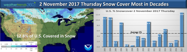
Snow cover today (12.8% of U.S.) is way above average per NOAA and that is just one factor that suggests colder/snowier days ahead. Early snow cover helps Arctic air build and become more widespread in Winter. It's not always 100% certain that early heavy snow cover means bad Winter but low snow cover like the past two years certainly increases the chance for a hotter/drier Winter like we had the past couple seasons. So, very different pattern setting up!
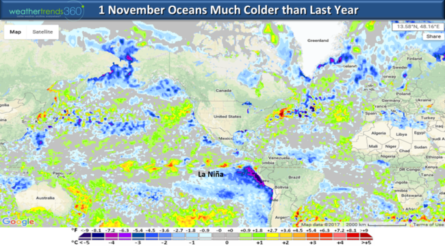
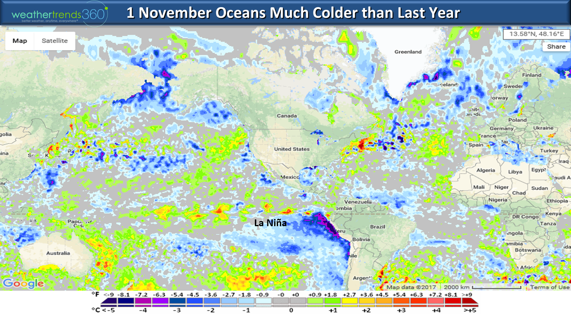
Another important factor is the oceans are COOLING vs this time last year when they were actually warming.
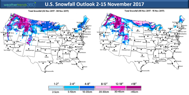
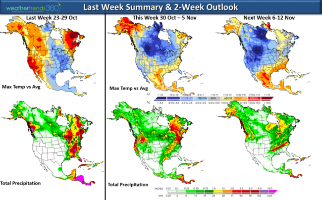
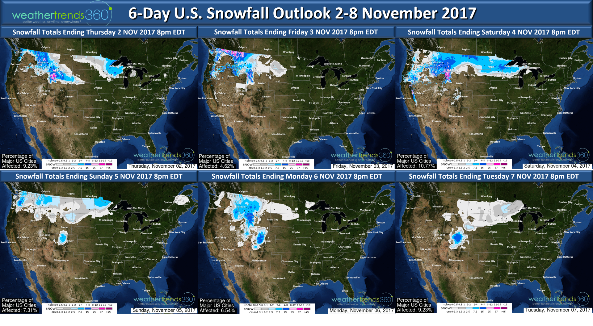
In the near term the 6-day snowfall outlook shows the cold and snow will pulse toward the West and North with several systems bringing heavier snowfall.

The 2-week outlook shows the interior Northeast has a good chance of seeing the first accumulating snows of the season the middle of next week (around the 8th) as a blast of cold air returns.
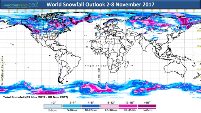
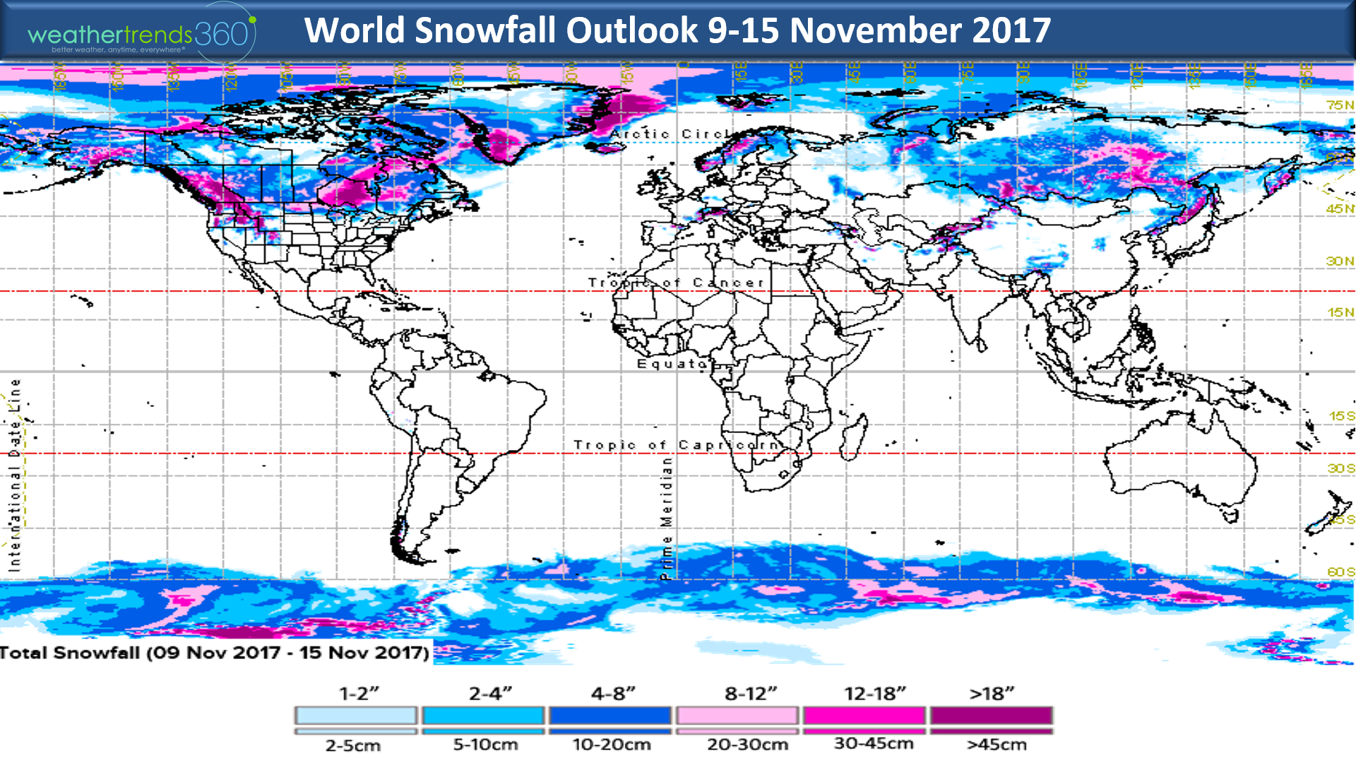
The global 2-week snowfall outlook shows a ton of snow pack will be building in Canada and Siberia which is something we didn't have last year in Canada. Recall this period last year was record hot and dry for all of North America.

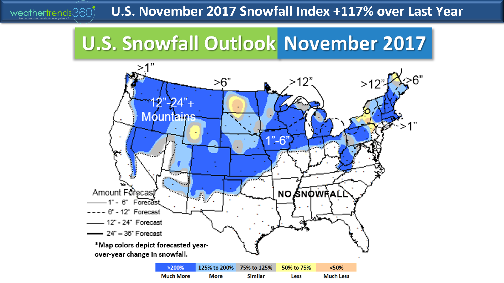
Our November snowfall outlook shows the snowiest conditions in several years with 117% more snowfall than last year and above average.
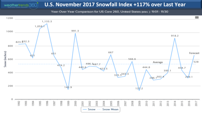
Most areas across the U.S. show twice as much snow as last year.

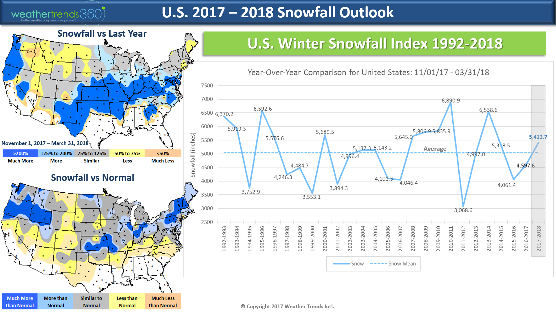
As a reminder our Winter snowfall outlook shows the most snowfall in 4 years.

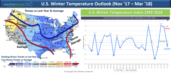
Winter temperatures are colder for 80% of the country with the northern tier of the U.S. colder than and generally warmer than average in the Southwest and coastal Southeast. That's all we have to say about that for now. :)
Have a great Thursday.
Happy Chilly Monday (30 October 2017)!
A major blast of Fall weather has invaded much of the U.S. just in time for Halloween. A very suspect Tropical Storm Philippe formed in the SW Caribbean and then tracked over South Florida this weekend but hard pressed to find any sustained winds anywhere near the levels forecast for the storm. Most gusts in South Florida were under 40 mph despite the NHC forecasts implying sustained winds of 52 mph gusting to 63 mph.
Philippe was sucked into the strong cold front on the East Coast with a stronger storm that developed in North Carolina. The combination did bring very heavy rain and very gusty winds to New England yesterday and today. Peak gusts were 82 mph Mashpee MA and 130 mph on top of Mount Washington in New Hampshire. Hundreds of thousands without power in New England. Somewhat ironic this occurred on the 5-year anniversary of Hurricane Sandy.CLICK ON IMAGES FOR LARGER VIEW.
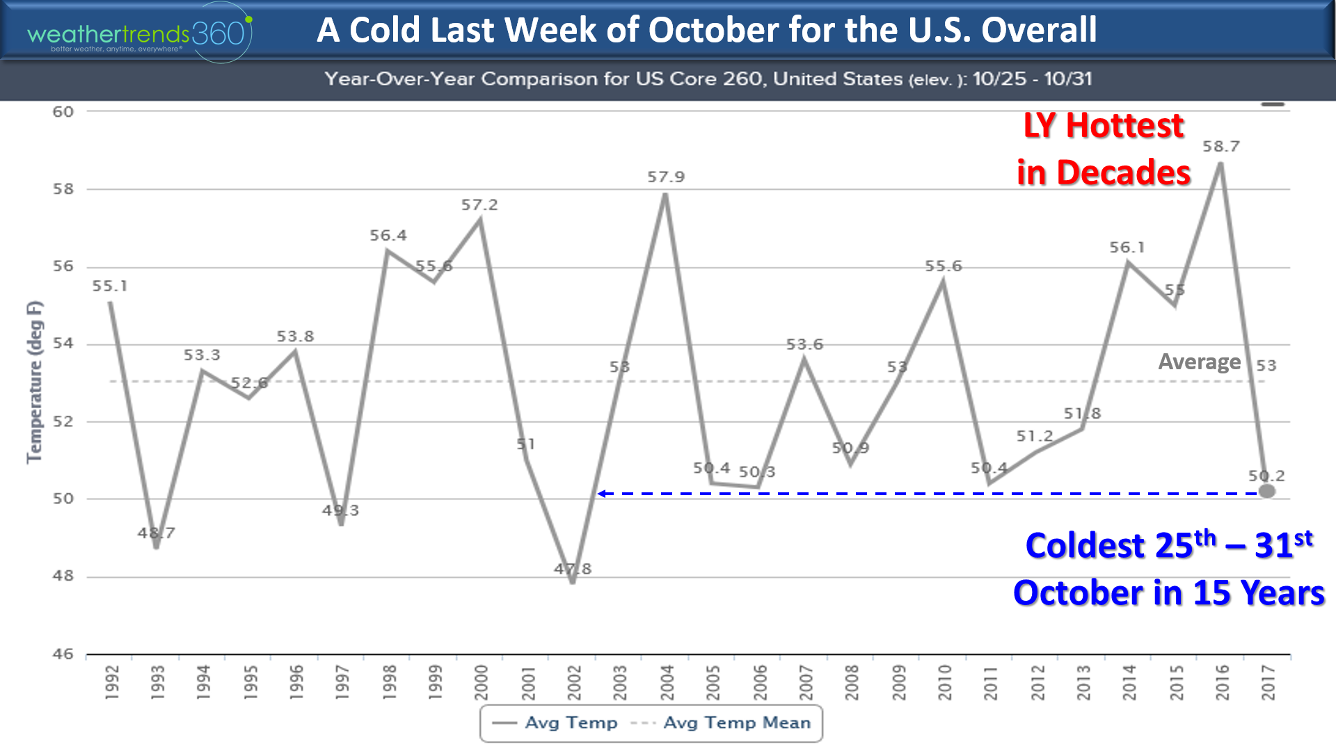
Nationally, October will go out on the spooky side with the coldest Halloween in 15 years and driest in 7 years for the U.S. overall. Over 80% of the country will have well below average temperatures tomorrow so bundle up if you're heading out.
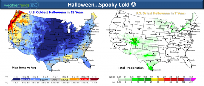
This last week of October will trend the coolest in 15 years for the U.S. overall with a wholesale change from last year's record hot last week of October.

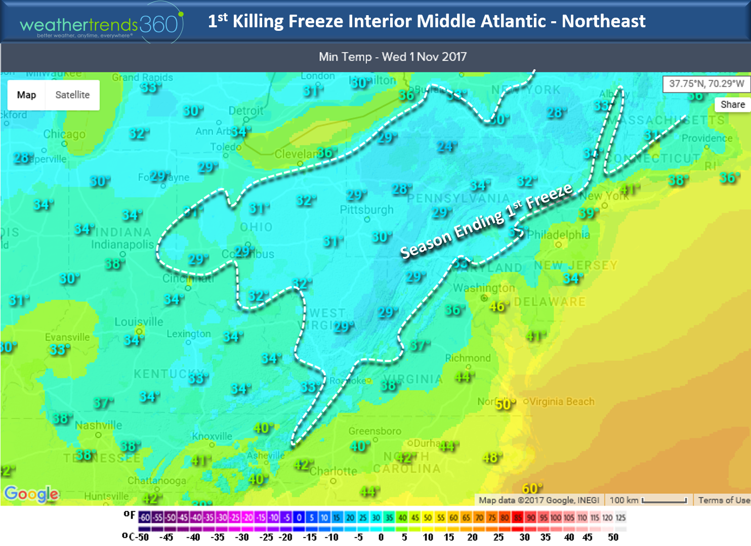
The cold will peak in the Northeast Wednesday morning (1 Nov) with interior locations having their 1st killing freeze of the season.

Another blast of cold air will invade the West this week with California expected to have the wettest first week of November in over 30 years! For the U.S. overall the 1st week of November is the stormiest/wettest in 22 years, snowiest in 6 years (west).

Prior to the big storm on the East Coast, Fall color was very pretty in spots but the winds have certainly put an end to that. Angelina Kirk is ready for Winter!

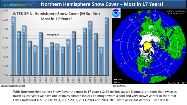
Speaking of Winter...we have some good news for snow lovers...you'll probably enjoy our Winter snowfall outlook. Snowiest in 4 years for the U.S. overall with a lot of parallels to the snowier winters of 2013-2014 and 2009-2010. Early snow cover across Siberia and now Canada along with a cooling Pacific Ocean (much colder than last year) and La Nina add up to an interesting Winter! The chart below shows week 39 snow cover across the Northern Hemisphere and it's the most in 17 years...not good if you don't like cold and snowy winters in the Northeastern U.S.! And over the next two weeks its the 2nd coldest and snowiest in 24+ years for Canada as a whole which lays down more snow pack. Last year the front half of November was record shattering warm in Canada. All adds up to a dramatically colder/snowier Winter!!!
wt360 customers can also get access to our monthly year-ahead snowfall forecast report and daily email 14-day snowfall outlook...see our Plans page that start at $299 for small businesses. Enterprise customers needing year-ahead business weather forecasts out 11 months and year-ahead sales forecast by category by store can email us at sales@weathertrends360.com.
Follow us on Facebook and Twitter for daily updates.
Have a great week! - Capt Kirk out.
The Northern Hemisphere is off to a much snowier start than last year and that is one of many factors pointing toward a much colder and snowier season here in North America. CLICK ON IMAGES FOR LARGER VIEW.
Snow cover today (12.8% of U.S.) is way above average per NOAA and that is just one factor that suggests colder/snowier days ahead. Early snow cover helps Arctic air build and become more widespread in Winter. It's not always 100% certain that early heavy snow cover means bad Winter but low snow cover like the past two years certainly increases the chance for a hotter/drier Winter like we had the past couple seasons. So, very different pattern setting up!

Another important factor is the oceans are COOLING vs this time last year when they were actually warming.
In the near term the 6-day snowfall outlook shows the cold and snow will pulse toward the West and North with several systems bringing heavier snowfall.
The 2-week outlook shows the interior Northeast has a good chance of seeing the first accumulating snows of the season the middle of next week (around the 8th) as a blast of cold air returns.

The global 2-week snowfall outlook shows a ton of snow pack will be building in Canada and Siberia which is something we didn't have last year in Canada. Recall this period last year was record hot and dry for all of North America.

Our November snowfall outlook shows the snowiest conditions in several years with 117% more snowfall than last year and above average.

Most areas across the U.S. show twice as much snow as last year.
As a reminder our Winter snowfall outlook shows the most snowfall in 4 years.
Winter temperatures are colder for 80% of the country with the northern tier of the U.S. colder than and generally warmer than average in the Southwest and coastal Southeast. That's all we have to say about that for now. :)

Have a great Thursday.
Happy Chilly Monday (30 October 2017)!
A major blast of Fall weather has invaded much of the U.S. just in time for Halloween. A very suspect Tropical Storm Philippe formed in the SW Caribbean and then tracked over South Florida this weekend but hard pressed to find any sustained winds anywhere near the levels forecast for the storm. Most gusts in South Florida were under 40 mph despite the NHC forecasts implying sustained winds of 52 mph gusting to 63 mph.
Philippe was sucked into the strong cold front on the East Coast with a stronger storm that developed in North Carolina. The combination did bring very heavy rain and very gusty winds to New England yesterday and today. Peak gusts were 82 mph Mashpee MA and 130 mph on top of Mount Washington in New Hampshire. Hundreds of thousands without power in New England. Somewhat ironic this occurred on the 5-year anniversary of Hurricane Sandy.CLICK ON IMAGES FOR LARGER VIEW.

Nationally, October will go out on the spooky side with the coldest Halloween in 15 years and driest in 7 years for the U.S. overall. Over 80% of the country will have well below average temperatures tomorrow so bundle up if you're heading out.

This last week of October will trend the coolest in 15 years for the U.S. overall with a wholesale change from last year's record hot last week of October.
The cold will peak in the Northeast Wednesday morning (1 Nov) with interior locations having their 1st killing freeze of the season.
Another blast of cold air will invade the West this week with California expected to have the wettest first week of November in over 30 years! For the U.S. overall the 1st week of November is the stormiest/wettest in 22 years, snowiest in 6 years (west).

Prior to the big storm on the East Coast, Fall color was very pretty in spots but the winds have certainly put an end to that. Angelina Kirk is ready for Winter!

Speaking of Winter...we have some good news for snow lovers...you'll probably enjoy our Winter snowfall outlook. Snowiest in 4 years for the U.S. overall with a lot of parallels to the snowier winters of 2013-2014 and 2009-2010. Early snow cover across Siberia and now Canada along with a cooling Pacific Ocean (much colder than last year) and La Nina add up to an interesting Winter! The chart below shows week 39 snow cover across the Northern Hemisphere and it's the most in 17 years...not good if you don't like cold and snowy winters in the Northeastern U.S.! And over the next two weeks its the 2nd coldest and snowiest in 24+ years for Canada as a whole which lays down more snow pack. Last year the front half of November was record shattering warm in Canada. All adds up to a dramatically colder/snowier Winter!!!

wt360 customers can also get access to our monthly year-ahead snowfall forecast report and daily email 14-day snowfall outlook...see our Plans page that start at $299 for small businesses. Enterprise customers needing year-ahead business weather forecasts out 11 months and year-ahead sales forecast by category by store can email us at sales@weathertrends360.com.
Follow us on Facebook and Twitter for daily updates.
Have a great week! - Capt Kirk out.