Star Date 22 Feb 2018 Thursday
Captain's Log
22 Feb 2018 Thursday Update:
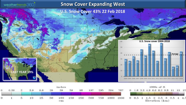
After record warm weather the past couple days in the East, the Arctic cold front has sent temps plummeting some 40 to 50 degrees in the East. With the cold weather finally invading the West, snow cover has been increasing for the snow deprived western half of the U.S. This has national snow cover up to 43% which is above the average of 37% and well above last year's meager 19%. CLICK ON IMAGES FOR LARGER VIEW.
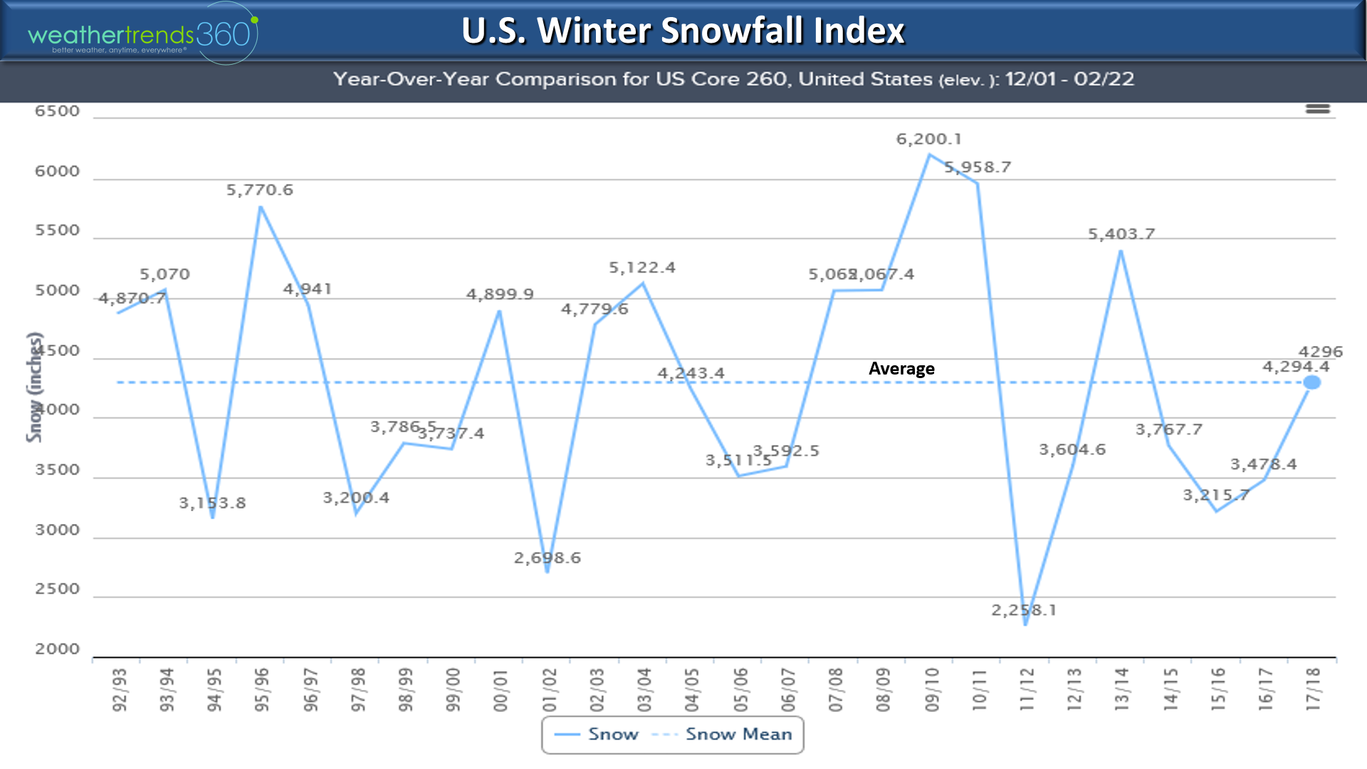
The U.S. Winter snowfall index (1 Dec - 22 Feb) is now exactly average for the Winter season and the most in 4 years, up 24% over last year. Winter is by no means over, so look for more cold and snow well into March across many areas of the U.S., including the big cities in the Northeast I-95 corridor!

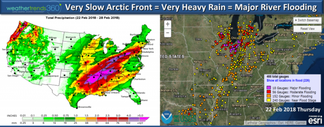
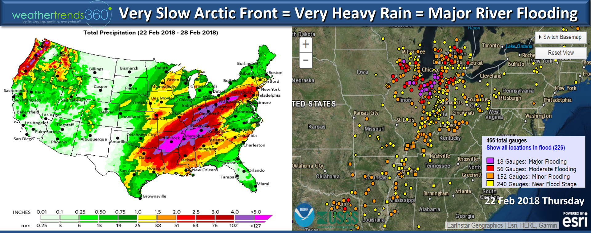
The big concern with the big thaw and heavy rain this week is widespread stream and river flooding. 18 river gauges Southeast of Chicago are at Major near record flood levels, 56 with moderate flood, 152 at minor flood and another 240 nearing flood stage. These will go higher with another 3-6"+ rainfall over the next few days from TX to NJ.
Stay safe!
Happy Monday (19 Feb 2018) ...especially happy if you're off today. :)
The roller coaster ride in the East continues after 60s and 70 last week gave way to a weekend snow storm in the Northeast and now back to more 70s midweek before it cools off a bit for the weekend. CLICK ON IMAGES FOR LARGER VIEW.
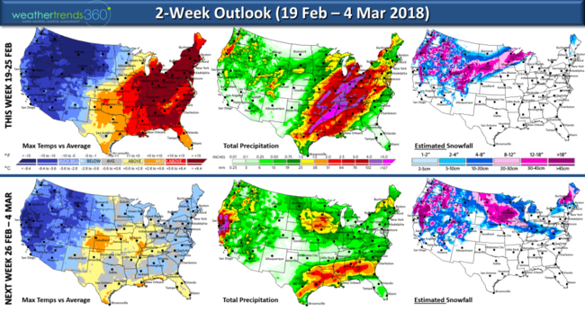
The West coast will finally get some Winter with cold, snow and frosty temps for the growing regions of Central California. With the milder temperatures in the Eastern U.S. will come a fair amount of rain with the potential for flooding from Arkansas to the Ohio Valley. The pattern begins to cool off for much of the country as we transition into March with a climate cycle favorable for widespread below average temperatures in the U.S.
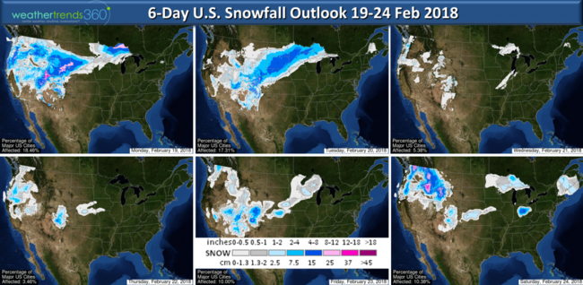
Snowfall over the next 6-days will shift to the West and Upper Plains states.

It has been the 2nd driest in decades for California this water year (1 Oct to date) making a wholesale change from last year's record wet season. La Nina's are not typically friendly to California as colder Pacific Ocean temperatures can lead to drought. CA will get some rain over the next couple weeks but not a ton.

Winter to date has made a wholesale flip flop from last year when the cold/snow was out west and this year's it been more in the Central and Eastern U.S.

Outside wt360 headquarters in Eastern PA we've had 30" of snow this Winter and another 7.5" this past weekend. We will likely add to that in March with cold/snow returning in the weeks ahead. Angelina enjoyed the snow storm but like most of us is ready for Spring!!!!
We hope you have a great week ahead! Follow us on Facebook and Twitter for daily updates. - Captain Kirk out.
After record warm weather the past couple days in the East, the Arctic cold front has sent temps plummeting some 40 to 50 degrees in the East. With the cold weather finally invading the West, snow cover has been increasing for the snow deprived western half of the U.S. This has national snow cover up to 43% which is above the average of 37% and well above last year's meager 19%. CLICK ON IMAGES FOR LARGER VIEW.

The U.S. Winter snowfall index (1 Dec - 22 Feb) is now exactly average for the Winter season and the most in 4 years, up 24% over last year. Winter is by no means over, so look for more cold and snow well into March across many areas of the U.S., including the big cities in the Northeast I-95 corridor!
The big concern with the big thaw and heavy rain this week is widespread stream and river flooding. 18 river gauges Southeast of Chicago are at Major near record flood levels, 56 with moderate flood, 152 at minor flood and another 240 nearing flood stage. These will go higher with another 3-6"+ rainfall over the next few days from TX to NJ.
Stay safe!
Happy Monday (19 Feb 2018) ...especially happy if you're off today. :)
The roller coaster ride in the East continues after 60s and 70 last week gave way to a weekend snow storm in the Northeast and now back to more 70s midweek before it cools off a bit for the weekend. CLICK ON IMAGES FOR LARGER VIEW.
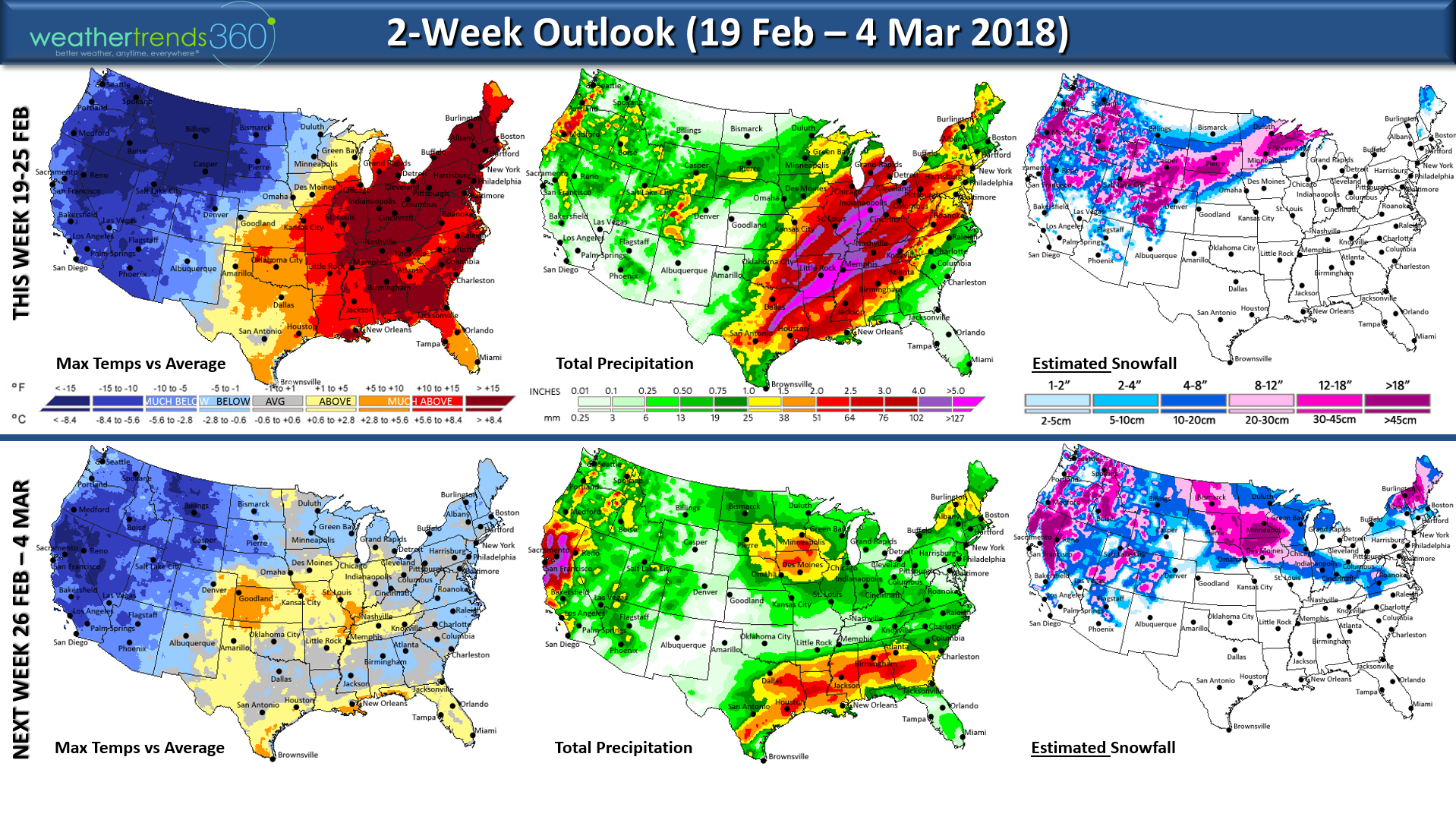
The West coast will finally get some Winter with cold, snow and frosty temps for the growing regions of Central California. With the milder temperatures in the Eastern U.S. will come a fair amount of rain with the potential for flooding from Arkansas to the Ohio Valley. The pattern begins to cool off for much of the country as we transition into March with a climate cycle favorable for widespread below average temperatures in the U.S.
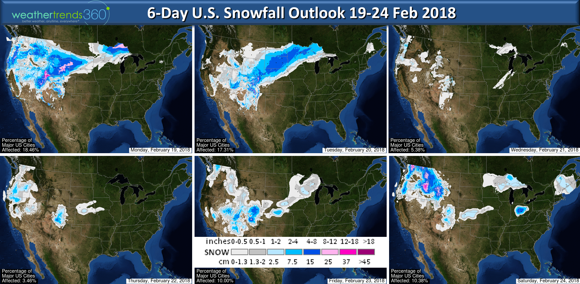
Snowfall over the next 6-days will shift to the West and Upper Plains states.
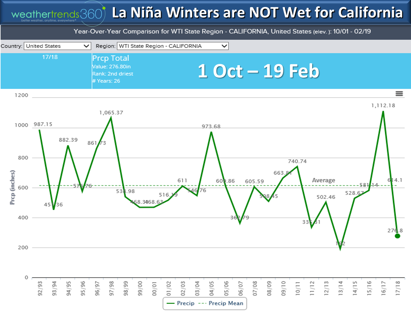
It has been the 2nd driest in decades for California this water year (1 Oct to date) making a wholesale change from last year's record wet season. La Nina's are not typically friendly to California as colder Pacific Ocean temperatures can lead to drought. CA will get some rain over the next couple weeks but not a ton.
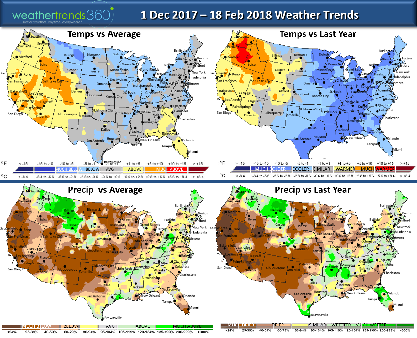
Winter to date has made a wholesale flip flop from last year when the cold/snow was out west and this year's it been more in the Central and Eastern U.S.

Outside wt360 headquarters in Eastern PA we've had 30" of snow this Winter and another 7.5" this past weekend. We will likely add to that in March with cold/snow returning in the weeks ahead. Angelina enjoyed the snow storm but like most of us is ready for Spring!!!!
We hope you have a great week ahead! Follow us on Facebook and Twitter for daily updates. - Captain Kirk out.