Star Date 23 May 2018 Wednesday Update
Captain's Log
Wednesday 23 May 2018 Update
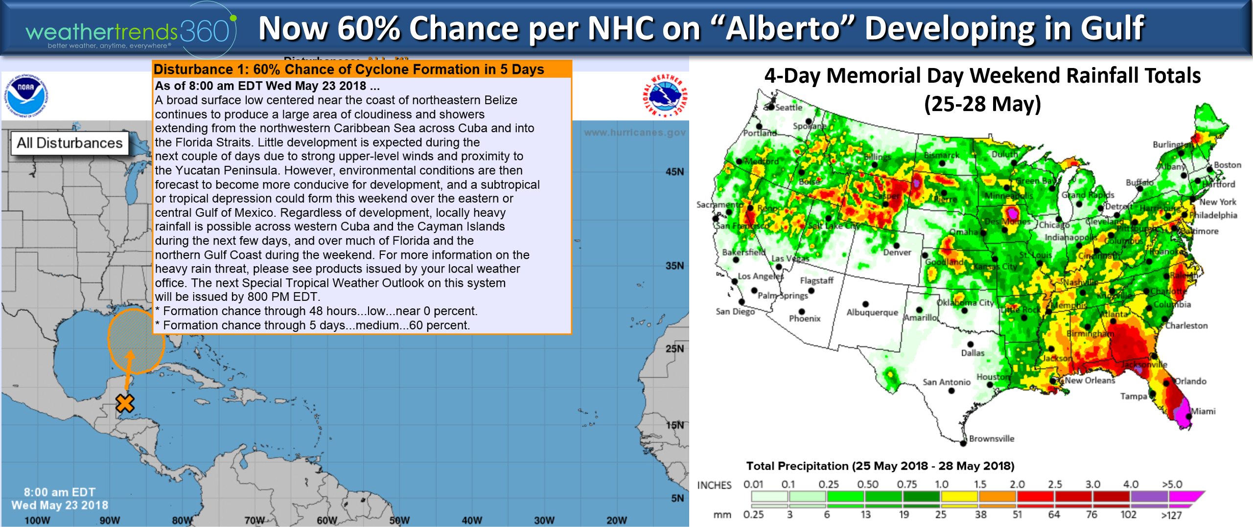
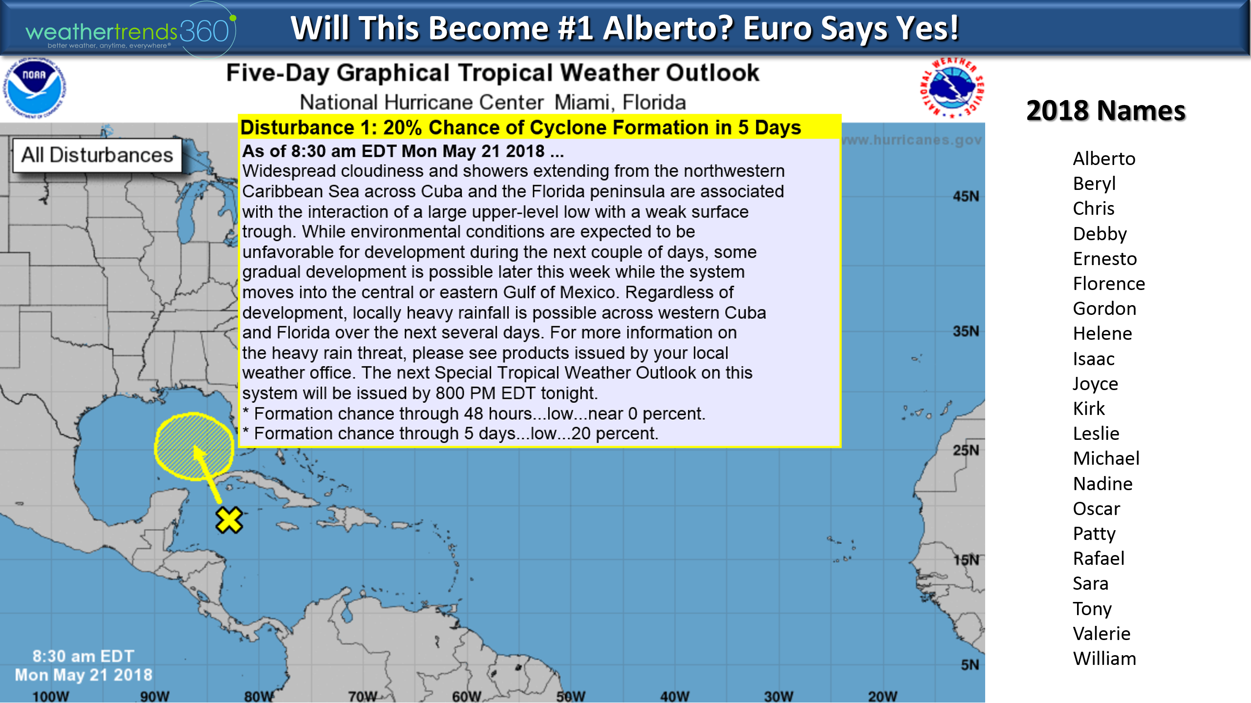
The National Hurricane Center has increased the odds to 60% of getting our first named Tropical Storm (Alberto) of the season this weekend in the North Central Gulf. A tad early but the MJO cycle is in phase 2 going to 3 which are very favorable for tropical systems to develop this time of year and the Gulf-Caribbean ocean temperatures are in the 80 to 82F range - plenty warm enough. Most models suggest a tropical storm makes landfall in LA-MS area this weekend. Hurricanes in May in the Gulf are very rare, and the only time a hurricane made landfall in May in the U.S. was way back in 1863!
These early threats in May and June were called out in our detailed hurricane forecast outlook (contact sales@weathertrends360.com) for more information on our detailed outlook.
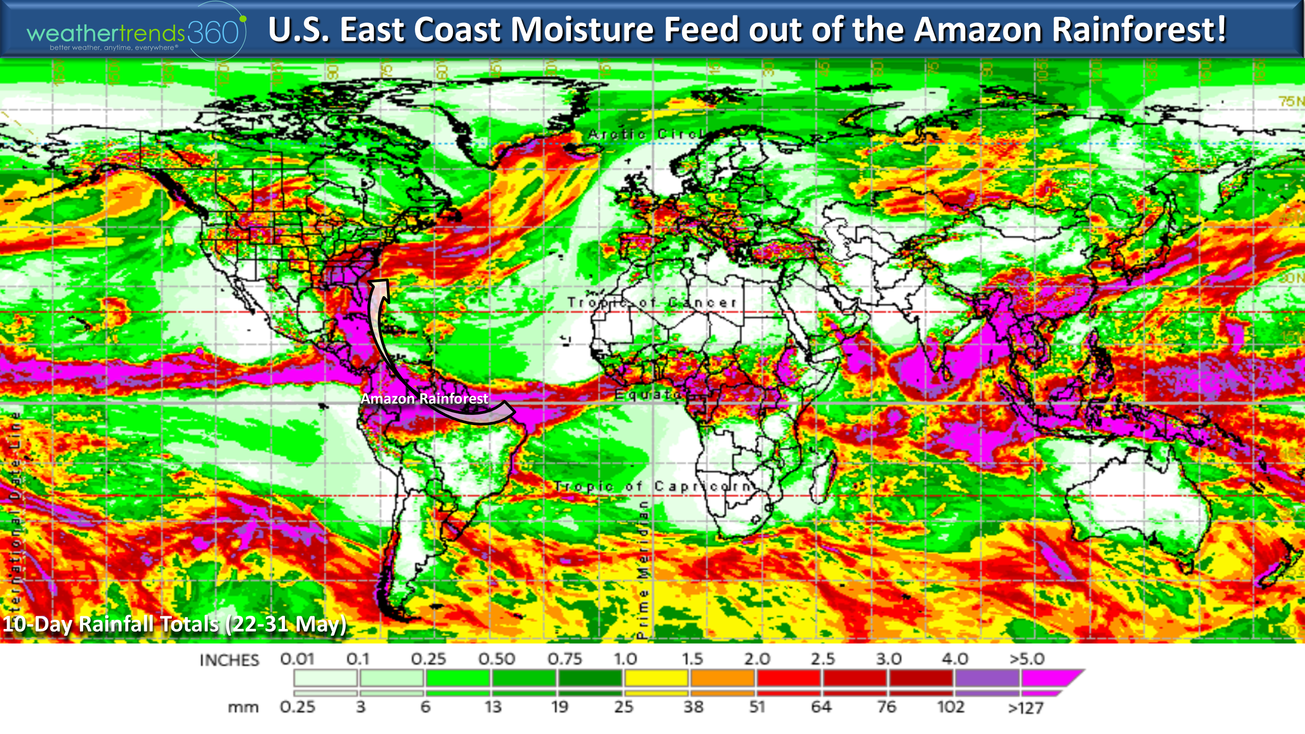
The worst weather this weekend will obviously be the Southeast/Gulf Coast with the tropical moisture feed that's literally right out of the Amazon Rainforest.
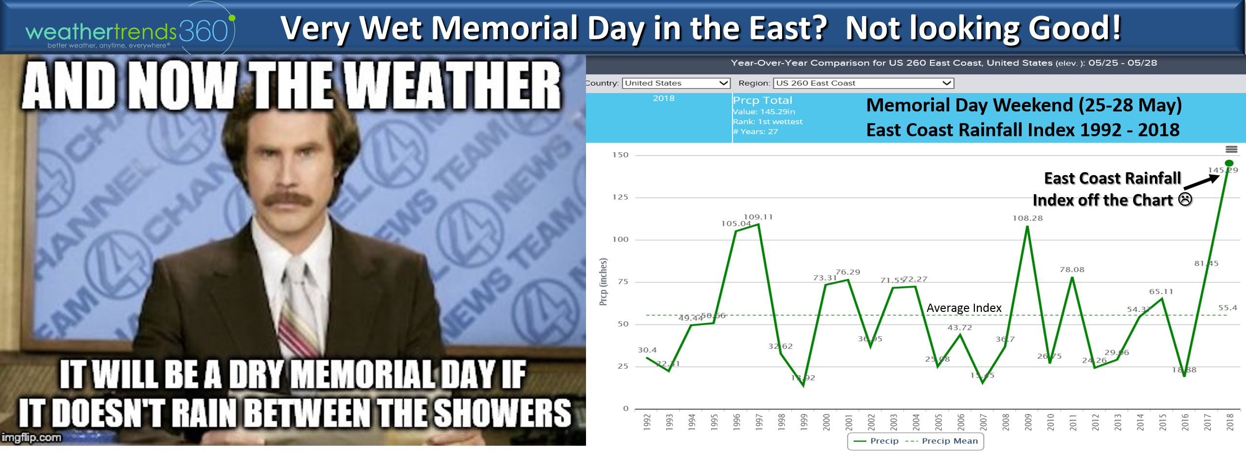
The Friday - Monday (25th - 28th) holiday period is the wettest in over 30 years for the Eastern U.S. and especially the Southeast. The weekend looks to start off nice in the East but end on a gloomy note the further south you go.
Have a great weekend!
Happy Monday 21 May 2018. :)
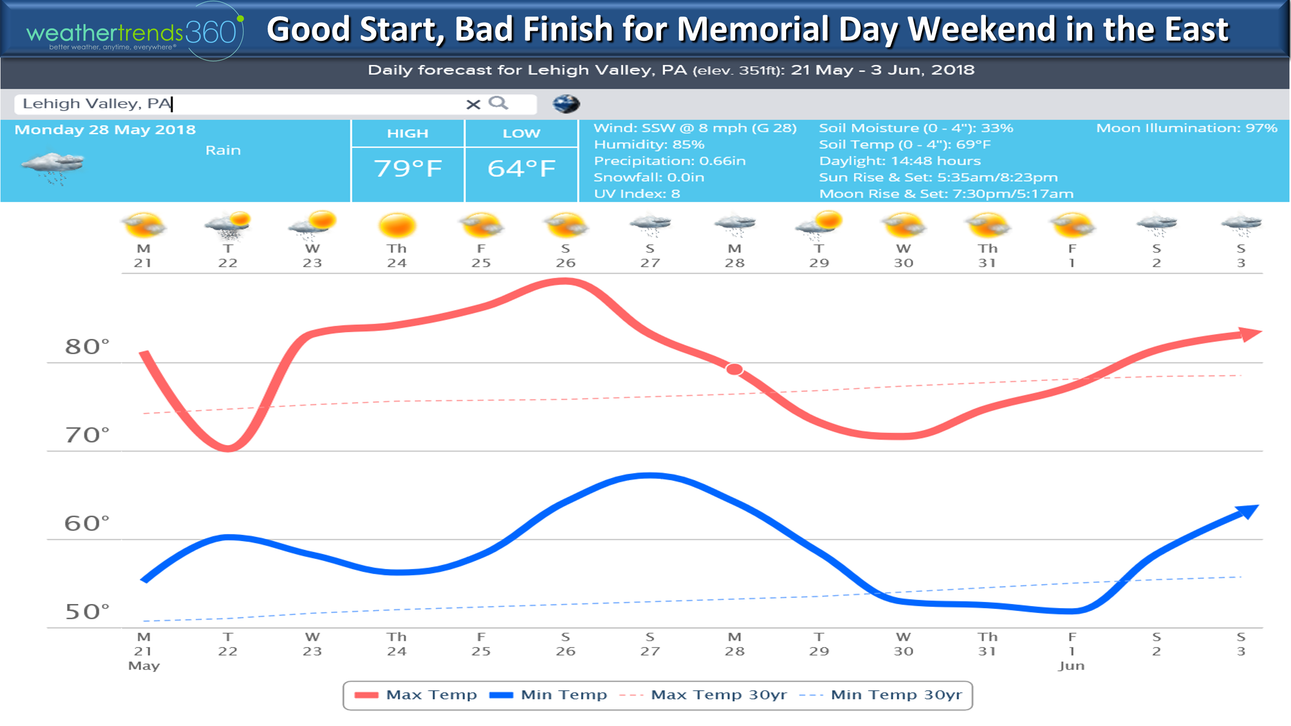
May in the U.S. is on pace to be the warmest in 123 years and wettest in over 30 years. It's a tad unusual to be both warm and wet as usually really warm May's tend to be drier. For the Western half of the country that trend is holding up with the warmest May in 21 years but also the driest in 11 years. After a dry start, the month has turned substantially wetter and that trends continues for the next two weeks. THIS WEEK (21-27 May) trends the warmest in over 30 years and 8th wettest. CLICK ON IMAGES FOR LARGER VIEW
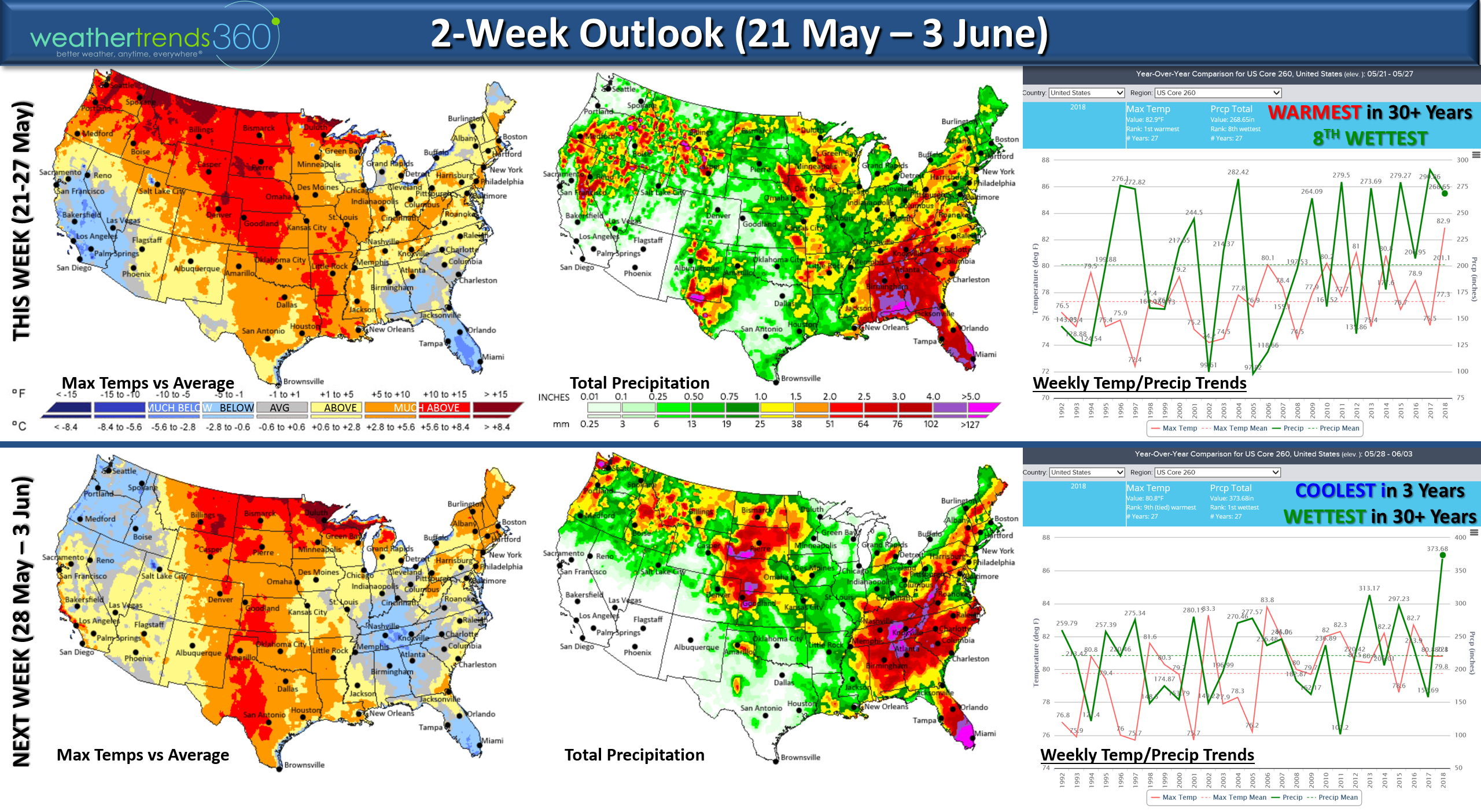
This weekend it's possible we get our first tropical system in the Gulf of Mexico with the Euro suggesting a hurricane in the North Central Gulf by Saturday. Even without the tropical system, the Memorial Day weekend looks to start off well but then turn stormy and wet for the later half of the weekend in the East. :( We know...you're sick of rain along the East Coast especially from NC to PA.
NEXT WEEK (28 May - 3 Jun) trends the coolest in 3 years for the U.S. overall but off the charts rainfall assuming the tropical system in the East. Our streak of 11 days of rainfall here at wt360 headquarters ends today with SUN! Yes we're happy about that.
The official start of the hurricane season is 1 June so it appears we're getting off to an early start. We think June is likely to be a much an above average month in terms of tropical threats so now is a good time to reflect on what happened last year and get prepared. wt360 is still concerned about the FL to NJ corridor this year for land falling hurricanes.
We will have frequent updates on our social media pages Facebook, Twitter, YouTube.
Have a great week! - Captain Kirk out.
The National Hurricane Center has increased the odds to 60% of getting our first named Tropical Storm (Alberto) of the season this weekend in the North Central Gulf. A tad early but the MJO cycle is in phase 2 going to 3 which are very favorable for tropical systems to develop this time of year and the Gulf-Caribbean ocean temperatures are in the 80 to 82F range - plenty warm enough. Most models suggest a tropical storm makes landfall in LA-MS area this weekend. Hurricanes in May in the Gulf are very rare, and the only time a hurricane made landfall in May in the U.S. was way back in 1863!
These early threats in May and June were called out in our detailed hurricane forecast outlook (contact sales@weathertrends360.com) for more information on our detailed outlook.
The worst weather this weekend will obviously be the Southeast/Gulf Coast with the tropical moisture feed that's literally right out of the Amazon Rainforest.
The Friday - Monday (25th - 28th) holiday period is the wettest in over 30 years for the Eastern U.S. and especially the Southeast. The weekend looks to start off nice in the East but end on a gloomy note the further south you go.
Have a great weekend!
Happy Monday 21 May 2018. :)
May in the U.S. is on pace to be the warmest in 123 years and wettest in over 30 years. It's a tad unusual to be both warm and wet as usually really warm May's tend to be drier. For the Western half of the country that trend is holding up with the warmest May in 21 years but also the driest in 11 years. After a dry start, the month has turned substantially wetter and that trends continues for the next two weeks. THIS WEEK (21-27 May) trends the warmest in over 30 years and 8th wettest. CLICK ON IMAGES FOR LARGER VIEW
This weekend it's possible we get our first tropical system in the Gulf of Mexico with the Euro suggesting a hurricane in the North Central Gulf by Saturday. Even without the tropical system, the Memorial Day weekend looks to start off well but then turn stormy and wet for the later half of the weekend in the East. :( We know...you're sick of rain along the East Coast especially from NC to PA.
NEXT WEEK (28 May - 3 Jun) trends the coolest in 3 years for the U.S. overall but off the charts rainfall assuming the tropical system in the East. Our streak of 11 days of rainfall here at wt360 headquarters ends today with SUN! Yes we're happy about that.
The official start of the hurricane season is 1 June so it appears we're getting off to an early start. We think June is likely to be a much an above average month in terms of tropical threats so now is a good time to reflect on what happened last year and get prepared. wt360 is still concerned about the FL to NJ corridor this year for land falling hurricanes.
We will have frequent updates on our social media pages Facebook, Twitter, YouTube.
Have a great week! - Captain Kirk out.