Star Date 24 April 2017 Monday
Captain's Log
Happy Monday! :)
Can you believe April is almost over? The year seems to be zipping by at Warp Speed...maybe we have a few loose bolts in our WARP5 Weather Center! ;) We even had our first Tropical Storm of the season (Arlene) but she lasted for about 1 day - not worthy of a name.

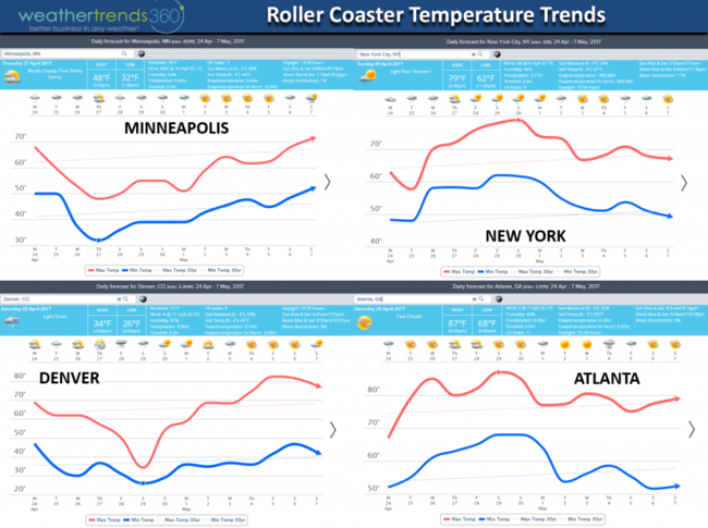
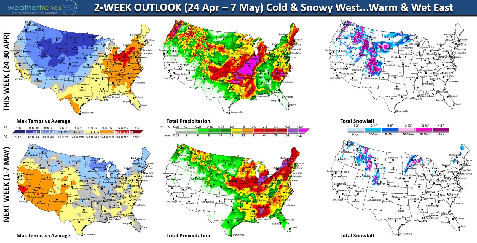
The week ahead shows a shocking pattern change for the Midwest with a major cold front moving through early this week while the East warms up ahead of this front. More severe weather will accompany this front in the Heartland adding to the already high tornado numbers. So far this year there has been 569 reported tornadoes which is 138% above the 3-year average and more 64% more than last year. CLICK ON IMAGES FOR LARGER VIEW

Of even greater significance is the likelihood of a hard freeze and widespread frost in the Midwest which could negatively impact any early planted crops.

Temperatures will plunge some 30 to 40 degrees in the Central U.S. with Thursday the coldest day. The East will get another taste of Summer as we head toward the weekend.
WTI was in the news this past week with mentions on CNBC TV Mad Money(5:55 mark of the video) and Fox Business.
For those of you needing a recent Angelina photo we caught her pretending to be a bunny this past week. :) Can't believe she's 15 months.

For daily updates visit us on Facebook and Twitter. Have a great week folks!
- Capt Kirk out.
Can you believe April is almost over? The year seems to be zipping by at Warp Speed...maybe we have a few loose bolts in our WARP5 Weather Center! ;) We even had our first Tropical Storm of the season (Arlene) but she lasted for about 1 day - not worthy of a name.

The week ahead shows a shocking pattern change for the Midwest with a major cold front moving through early this week while the East warms up ahead of this front. More severe weather will accompany this front in the Heartland adding to the already high tornado numbers. So far this year there has been 569 reported tornadoes which is 138% above the 3-year average and more 64% more than last year. CLICK ON IMAGES FOR LARGER VIEW
Of even greater significance is the likelihood of a hard freeze and widespread frost in the Midwest which could negatively impact any early planted crops.
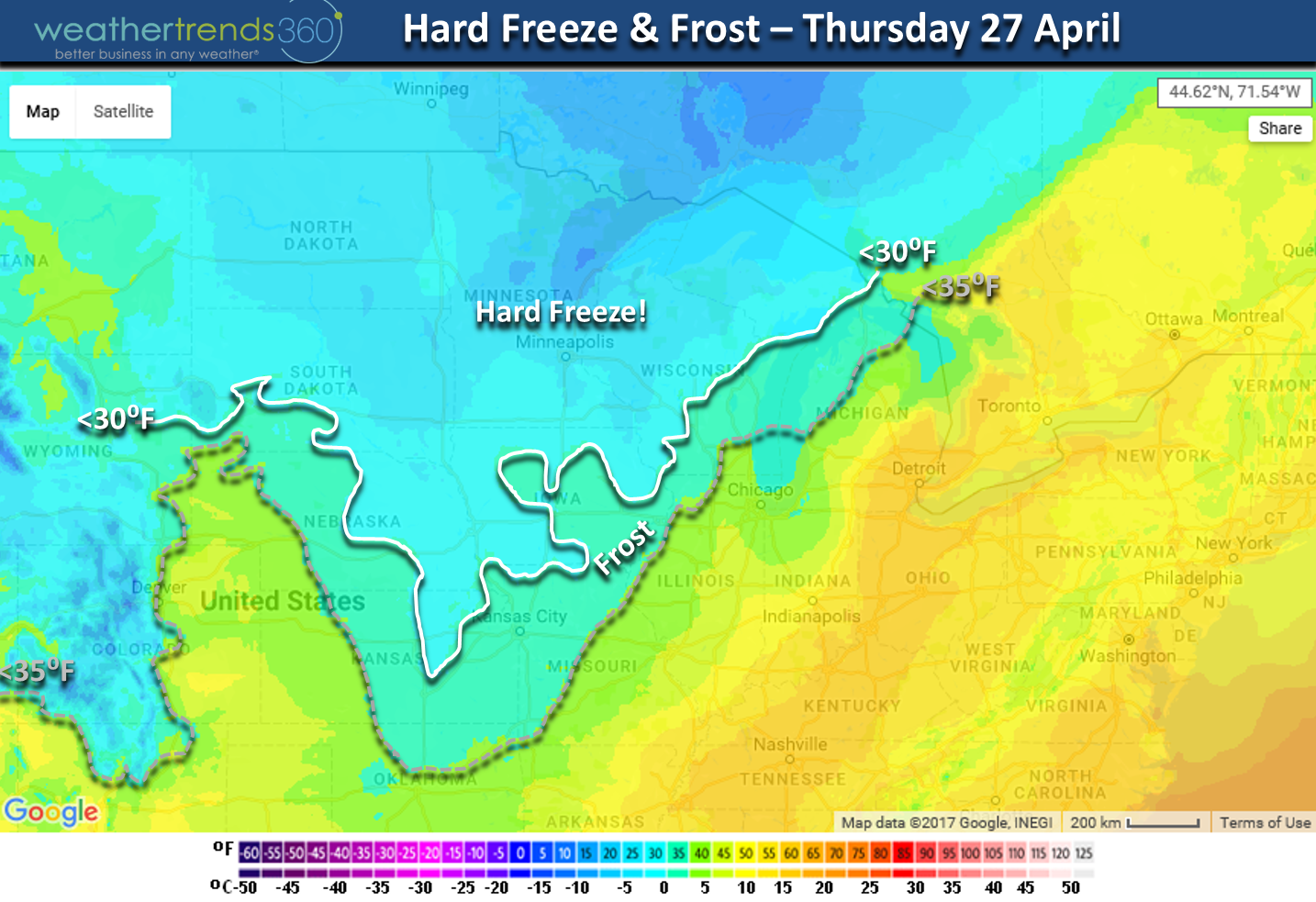
Temperatures will plunge some 30 to 40 degrees in the Central U.S. with Thursday the coldest day. The East will get another taste of Summer as we head toward the weekend.

WTI was in the news this past week with mentions on CNBC TV Mad Money(5:55 mark of the video) and Fox Business.
For those of you needing a recent Angelina photo we caught her pretending to be a bunny this past week. :) Can't believe she's 15 months.

For daily updates visit us on Facebook and Twitter. Have a great week folks!
- Capt Kirk out.