Star Date: 25 July 2016 Monday
Captain's Log
Happy Monday! :)
LAST WEEK (17-23 JULY): brought the first of a couple major widespread heat-waves with the U.S. overall having the 2nd hottest 3rd week of July on record, second only to 2011. National temperatures were +3F above average. Rainfall was the 4th driest of the past 25 years trending 20% below average for the nation overall.
THIS WEEK(24-31 JULY): The near record hot weather continues in the East while the Midwest gets a brief cool down. Nationally this last week of July trends the hottest in 11 years and 3rd hottest of the past 25 years (+2.4F above average). Rainfall is near average nationally, wettest in 3 years. Hawaii was having the 2nd driest start to the year in over 25 years but got some relief from Tropical Storm Darby this weekend and today with the wettest last week of July in 19 years.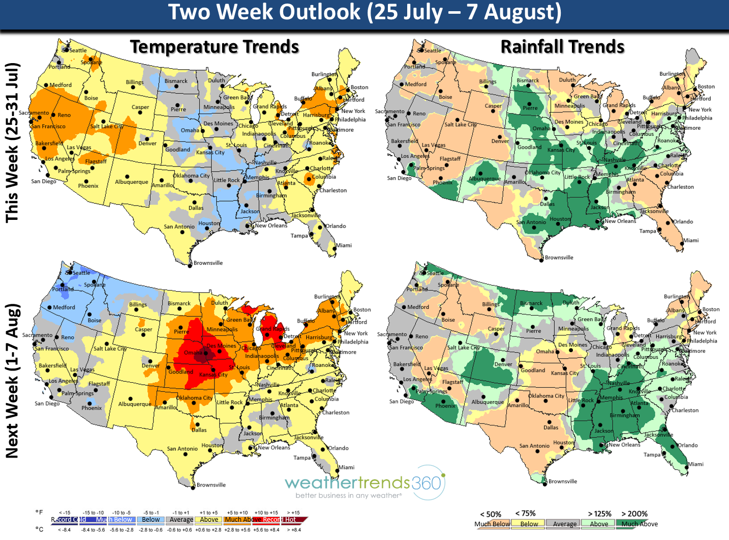 NEXT WEEK (1-7 AUG): Major heat-wave #2 could be worse than this past one with a major heat-dome likely to park somewhere over Iowa. The 25-year trend chart shows record breaking heat around Omaha, Nebraska with a weekly average max temperature over 103F. We'll see if it stays that hot but right now it looks like another major heat-wave on the way and worse for than this first one for the Western and Central Corn Belt. Corn Belt temperatures to start August are almost off the charts with record 121 year heat and slightly below average rainfall. Nationally August looks to get off to the hottest start on record with national temperatures +3.3F above average. Rainfall appears abundant, unusual in high heat scenarios, but likely to trend the most in 13 years for the U.S. overall. Heaviest rains appear to be in the drought stricken Southeast.
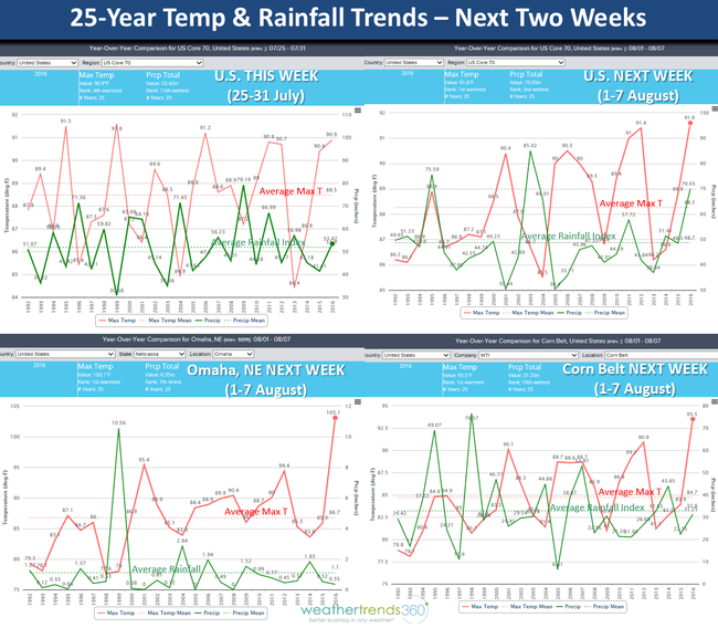
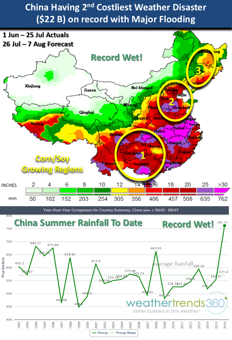
CHINA FLOODS: China is has gone from a dry Summer pattern the past couple years to off the charts record flooding. Many areas have had 25"-40" the past couple months to include China's crop growing regions. Government sources say this is already the 2nd costliest disaster ($22 Billion) in their history and it's going to get worse. The early August period looks to bring more record breaking rainfall with widespread 6-15" rain totals to already inundated areas. At least 40% of China's crop regions are likely decimated by this flooding impacting corn, soy, wheat and even vineyards in Shandong Province.
LA NINA: The Equatorial Pacific Ocean is very much in a La Nina pattern and the weather around the world is classic La Nina with the flooding and record rain in Southeast Asia, Australia, sub-Sahara Africa, hot/dry'ish Summer in the U.S., etc. Summer to date in the U.S. is trending the 2nd hottest on record and 4th driest of the past 28 years. Compared to this time last year there is nothing at all similar about this weather pattern.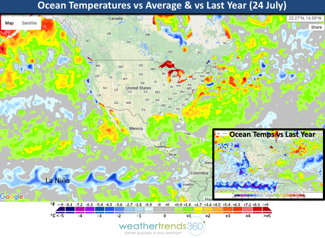
We hope you have a great week folks!
- Capt Kirk out.
LAST WEEK (17-23 JULY): brought the first of a couple major widespread heat-waves with the U.S. overall having the 2nd hottest 3rd week of July on record, second only to 2011. National temperatures were +3F above average. Rainfall was the 4th driest of the past 25 years trending 20% below average for the nation overall.
THIS WEEK(24-31 JULY): The near record hot weather continues in the East while the Midwest gets a brief cool down. Nationally this last week of July trends the hottest in 11 years and 3rd hottest of the past 25 years (+2.4F above average). Rainfall is near average nationally, wettest in 3 years. Hawaii was having the 2nd driest start to the year in over 25 years but got some relief from Tropical Storm Darby this weekend and today with the wettest last week of July in 19 years.
NEXT WEEK (1-7 AUG): Major heat-wave #2 could be worse than this past one with a major heat-dome likely to park somewhere over Iowa. The 25-year trend chart shows record breaking heat around Omaha, Nebraska with a weekly average max temperature over 103F. We'll see if it stays that hot but right now it looks like another major heat-wave on the way and worse for than this first one for the Western and Central Corn Belt. Corn Belt temperatures to start August are almost off the charts with record 121 year heat and slightly below average rainfall. Nationally August looks to get off to the hottest start on record with national temperatures +3.3F above average. Rainfall appears abundant, unusual in high heat scenarios, but likely to trend the most in 13 years for the U.S. overall. Heaviest rains appear to be in the drought stricken Southeast.
CHINA FLOODS: China is has gone from a dry Summer pattern the past couple years to off the charts record flooding. Many areas have had 25"-40" the past couple months to include China's crop growing regions. Government sources say this is already the 2nd costliest disaster ($22 Billion) in their history and it's going to get worse. The early August period looks to bring more record breaking rainfall with widespread 6-15" rain totals to already inundated areas. At least 40% of China's crop regions are likely decimated by this flooding impacting corn, soy, wheat and even vineyards in Shandong Province.
LA NINA: The Equatorial Pacific Ocean is very much in a La Nina pattern and the weather around the world is classic La Nina with the flooding and record rain in Southeast Asia, Australia, sub-Sahara Africa, hot/dry'ish Summer in the U.S., etc. Summer to date in the U.S. is trending the 2nd hottest on record and 4th driest of the past 28 years. Compared to this time last year there is nothing at all similar about this weather pattern.

We hope you have a great week folks!
- Capt Kirk out.