Star Date 25 July 2017 Tuesday
Captain's Log
Happy Tuesday! :)
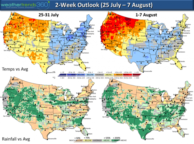
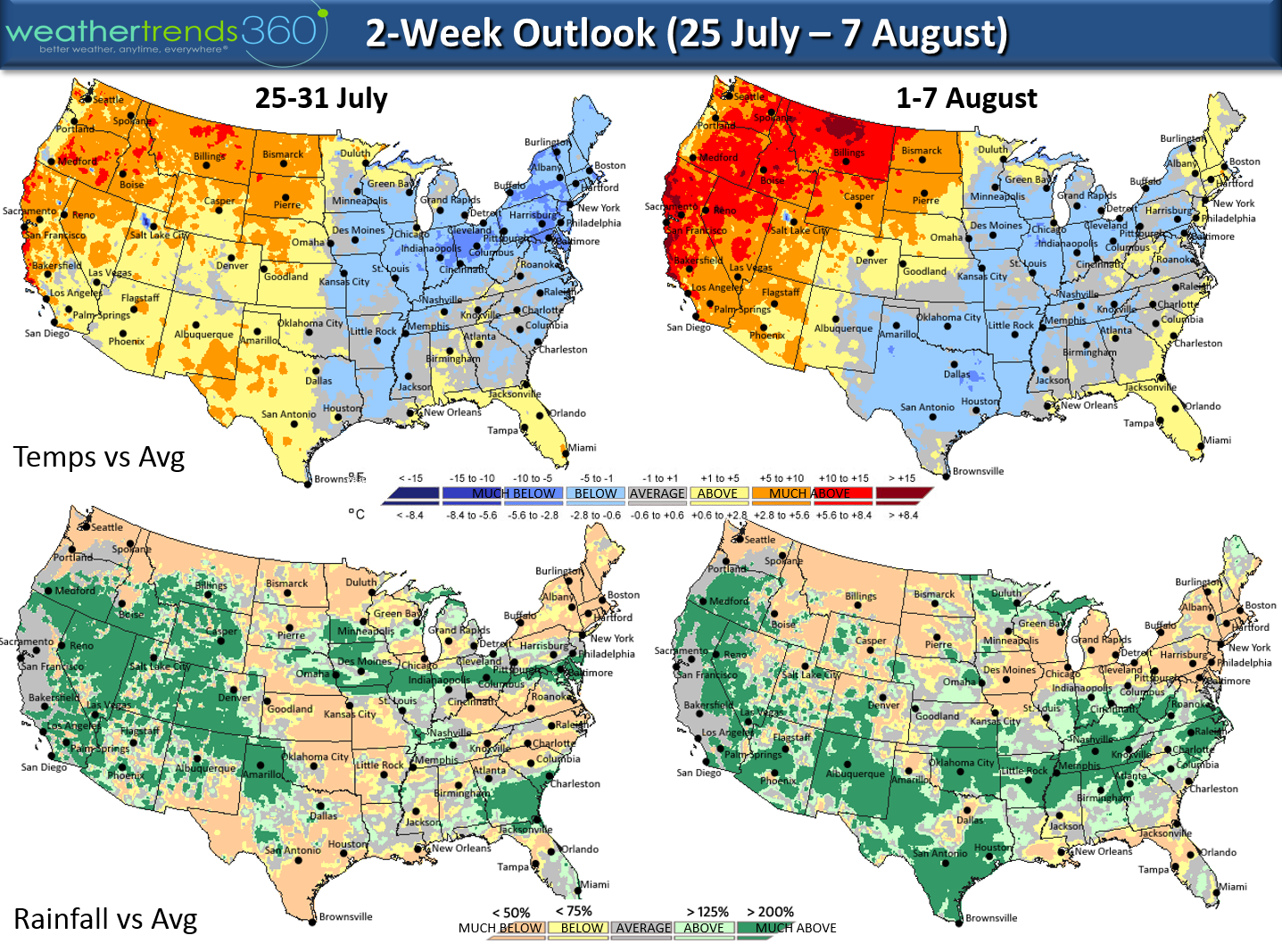
A much cooler pattern is setting up for the Eastern half of the U.S. to close out July while areas that have been very hot remain very hot- Upper Plains, N. Rocky Mountains. The heat builds in the West as we transition into August with only a brief warm up in the East. Later half of August should turn cooler East and remain hotter West. CLICK ON IMAGES FOR LARGER VIEW.
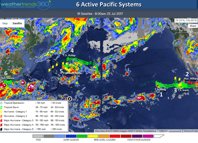
The tropics remain quite in the Atlantic basin while the East Pacific is very active with 2 hurricanes and 1 tropical storm and 3 more systems in the W. Pacific for 6 active systems. Hurricane Hillary likely to become major Hurricane and then die a slow death as she runs into cooler water.
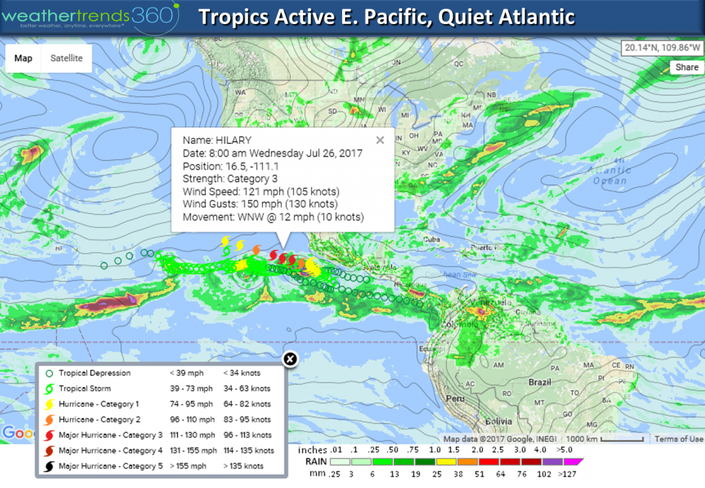
A couple more systems likely to develop in the Pacific this week so this is classic central based weak El Niño type pattern with an active E Pacific but quiet Atlantic.
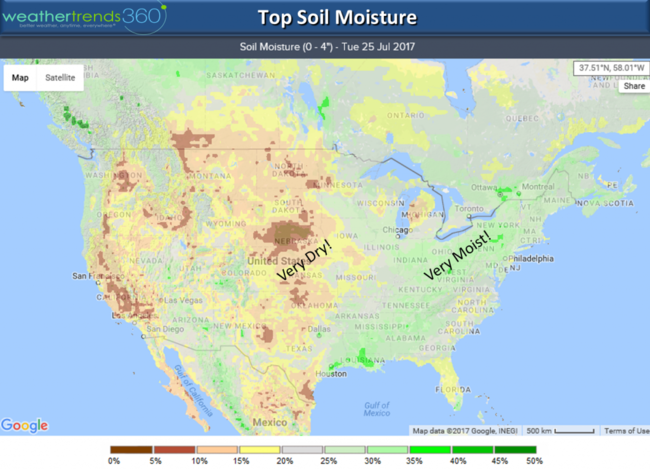
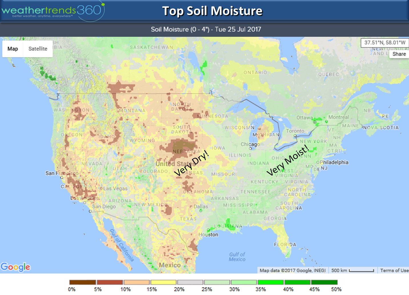
Soil Moisture in Summer will usually show how where it will be hotter as dry soil tends to be hotter (West) while wetter soil makes it cooler but insanely humid (East). Nebraska shows exceptionally low soil moisture levels at 5%, almost desert like while area in Pennsylvania are over 35%, very wet.
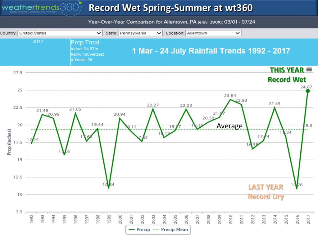
Outside wt360 headquarters in Bethlehem, PA the Spring-Summer (1 Mar - 24 Jul) has made the greatest year-over-year change toward wetter weather on record. Last year we were having the driest year in over 30 years with drought conditions and this year one of the wettest on record.
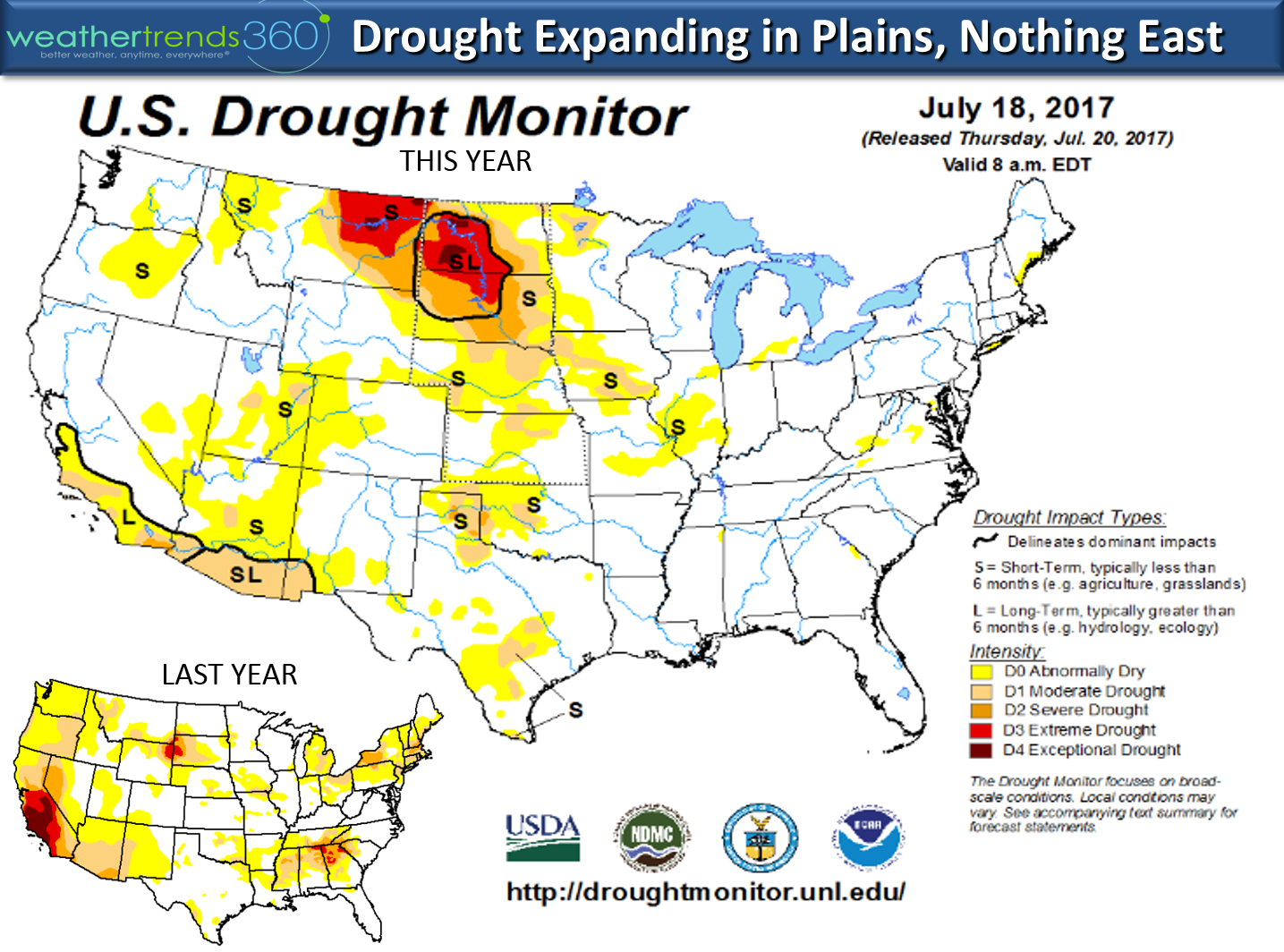
The change in the drought map is pretty amazing with both the East and West coasts fully covered while the Central U.S. worsens.

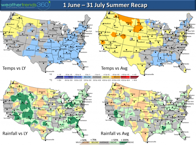
Summer (1 June - 25 July) has been warm in the East but still cooler than last year and again much wetter. The Plains and West have been much hotter and drier than a year ago.
We hope you have a great week! - Captain Kirk out.
A much cooler pattern is setting up for the Eastern half of the U.S. to close out July while areas that have been very hot remain very hot- Upper Plains, N. Rocky Mountains. The heat builds in the West as we transition into August with only a brief warm up in the East. Later half of August should turn cooler East and remain hotter West. CLICK ON IMAGES FOR LARGER VIEW.
The tropics remain quite in the Atlantic basin while the East Pacific is very active with 2 hurricanes and 1 tropical storm and 3 more systems in the W. Pacific for 6 active systems. Hurricane Hillary likely to become major Hurricane and then die a slow death as she runs into cooler water.
A couple more systems likely to develop in the Pacific this week so this is classic central based weak El Niño type pattern with an active E Pacific but quiet Atlantic.

Soil Moisture in Summer will usually show how where it will be hotter as dry soil tends to be hotter (West) while wetter soil makes it cooler but insanely humid (East). Nebraska shows exceptionally low soil moisture levels at 5%, almost desert like while area in Pennsylvania are over 35%, very wet.
Outside wt360 headquarters in Bethlehem, PA the Spring-Summer (1 Mar - 24 Jul) has made the greatest year-over-year change toward wetter weather on record. Last year we were having the driest year in over 30 years with drought conditions and this year one of the wettest on record.
The change in the drought map is pretty amazing with both the East and West coasts fully covered while the Central U.S. worsens.
Summer (1 June - 25 July) has been warm in the East but still cooler than last year and again much wetter. The Plains and West have been much hotter and drier than a year ago.

We hope you have a great week! - Captain Kirk out.