Star Date 25 Sept 2017 Monday
Captain's Log
Happy Monday.
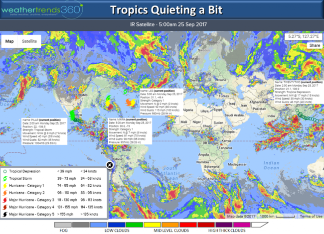
The tropics are showing signs of quieting a bit and both Hurricanes Maria and Lee will remain fish storms until they merge and impact Ireland this weekend. CflipLICK ON IMAGES FOR LARGER VIEW.
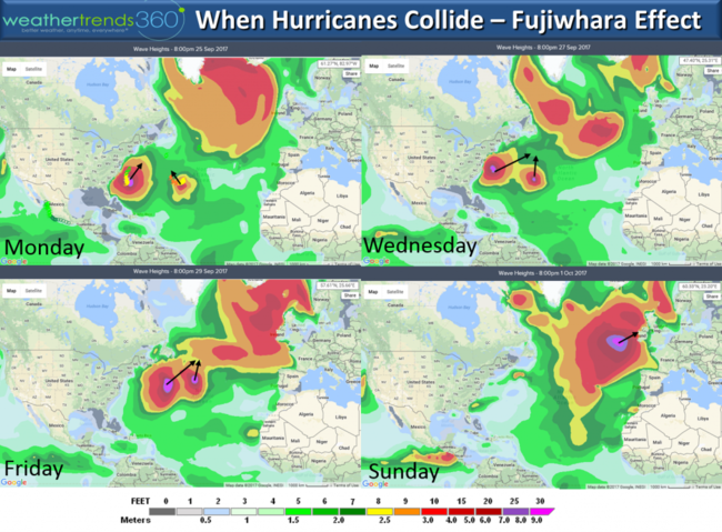
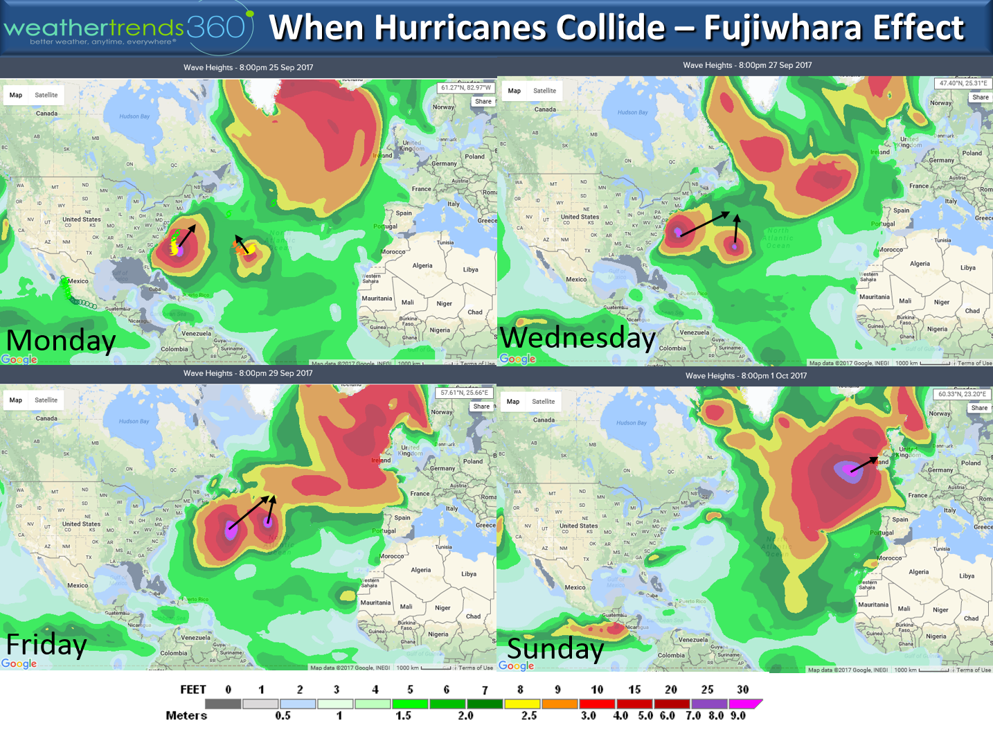
The wt360 wave height forecast maps shows what happens when hurricanes collide...it's called the Fujiwhara Effect. Usually when two hurricanes get within 870 miles of each other the stronger or bigger of the two will absorb the smaller one. They can at times appear to be dancing or rotating around each other until this collision takes place. This does not make the storm any stronger but it's neat to see the collision. The forecast wave maps show this effect with Ireland likely to see the merged storm on Sunday with 30 foot seas just off the coast.
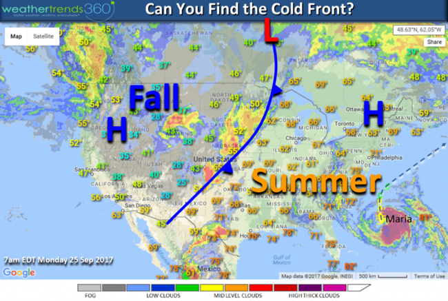
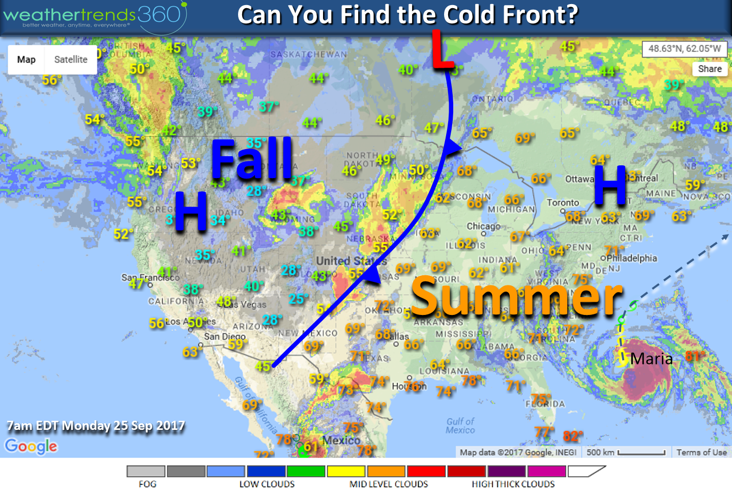
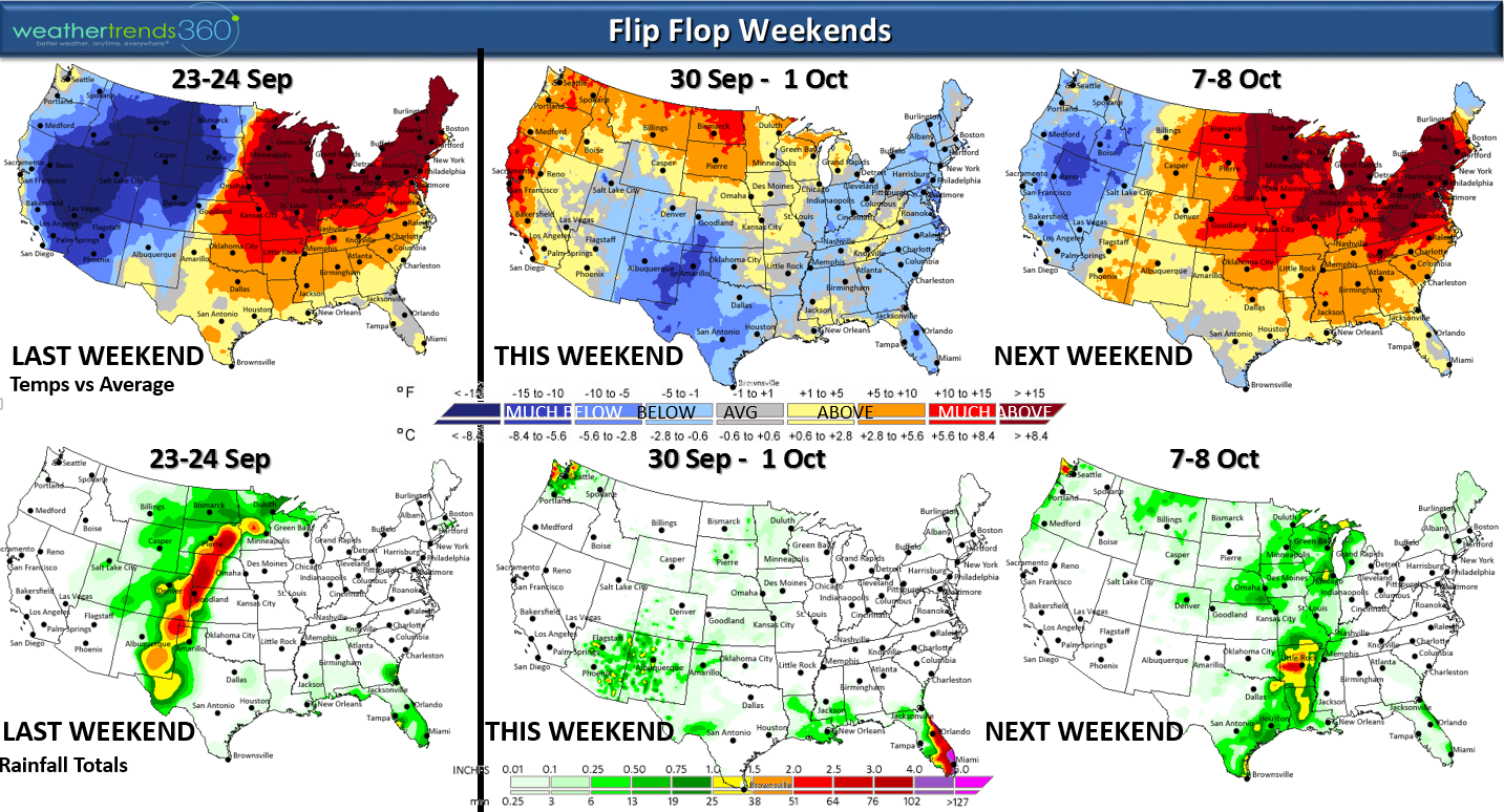
It's not too hard to find the cold front this morning with snow and cold out West and Summer-like temperatures in the East.
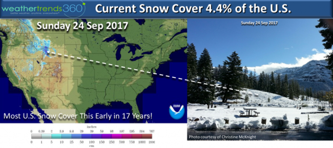
Yes they had 1-2 feet of snow on the last day of Summer and first day of Fall in Yellowstone National Park WY! The snow was pretty widespread for this time of year with 4.4% of the U.S. blanketed in snow making it the snowiest start to Fall in 17 years.
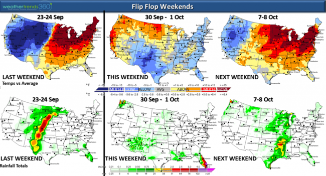
But the progressive flip flop weather pattern will bring the cool weather East and hot again out West before another surge of colder weather moves back to the West. Pick your favorite weekend as they'll be up and down.
World ocean temperatures are dramatically colder than this time last year and that's a harbinger of things to come for this Winter!
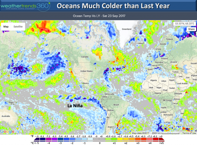
Yes the weak to moderate La Nina, cooler North Pacific, cooler NW Atlantic, weaker sun all point toward a colder and snowier Winter in the Central and Eastern U.S. That's all we have to say about that for now. :)
Check out our latest blog on the Fall foliage outlook - should be extra nice in the East and not so great out West.
And how cool is this...Lehigh Valley Business names wt360's WARP5 Weather Center studio as one of the coolest office spaces in Eastern PA! :) We already knew that! Warp Speed Ahead.
We hope you have a great week! - Captain Kirk out.
The tropics are showing signs of quieting a bit and both Hurricanes Maria and Lee will remain fish storms until they merge and impact Ireland this weekend. CflipLICK ON IMAGES FOR LARGER VIEW.

The wt360 wave height forecast maps shows what happens when hurricanes collide...it's called the Fujiwhara Effect. Usually when two hurricanes get within 870 miles of each other the stronger or bigger of the two will absorb the smaller one. They can at times appear to be dancing or rotating around each other until this collision takes place. This does not make the storm any stronger but it's neat to see the collision. The forecast wave maps show this effect with Ireland likely to see the merged storm on Sunday with 30 foot seas just off the coast.
It's not too hard to find the cold front this morning with snow and cold out West and Summer-like temperatures in the East.
Yes they had 1-2 feet of snow on the last day of Summer and first day of Fall in Yellowstone National Park WY! The snow was pretty widespread for this time of year with 4.4% of the U.S. blanketed in snow making it the snowiest start to Fall in 17 years.

But the progressive flip flop weather pattern will bring the cool weather East and hot again out West before another surge of colder weather moves back to the West. Pick your favorite weekend as they'll be up and down.
World ocean temperatures are dramatically colder than this time last year and that's a harbinger of things to come for this Winter!

Yes the weak to moderate La Nina, cooler North Pacific, cooler NW Atlantic, weaker sun all point toward a colder and snowier Winter in the Central and Eastern U.S. That's all we have to say about that for now. :)
Check out our latest blog on the Fall foliage outlook - should be extra nice in the East and not so great out West.
And how cool is this...Lehigh Valley Business names wt360's WARP5 Weather Center studio as one of the coolest office spaces in Eastern PA! :) We already knew that! Warp Speed Ahead.
We hope you have a great week! - Captain Kirk out.