Star Date 29 August 2016 Monday
Captain's Log
Happy Monday! :)
August 2016will end up as the 3rd hottest in 25+ years for the U.S. overall and hottest since 2011. The Great Lakes, Ohio Valley and Northeast showed the greatest temperature anomalies while the West Coast was also on the warmer than average side. The cool spots were the Rocky Mountain states while the Plains were near average. Hot 90F days were the 5th most in 25+ years for the U.S. overall. Rainfall was the #1 wettest in 25 years for the U.S. overall due in large part to the flooding event in the South Central U.S. into the Southern Midwest.
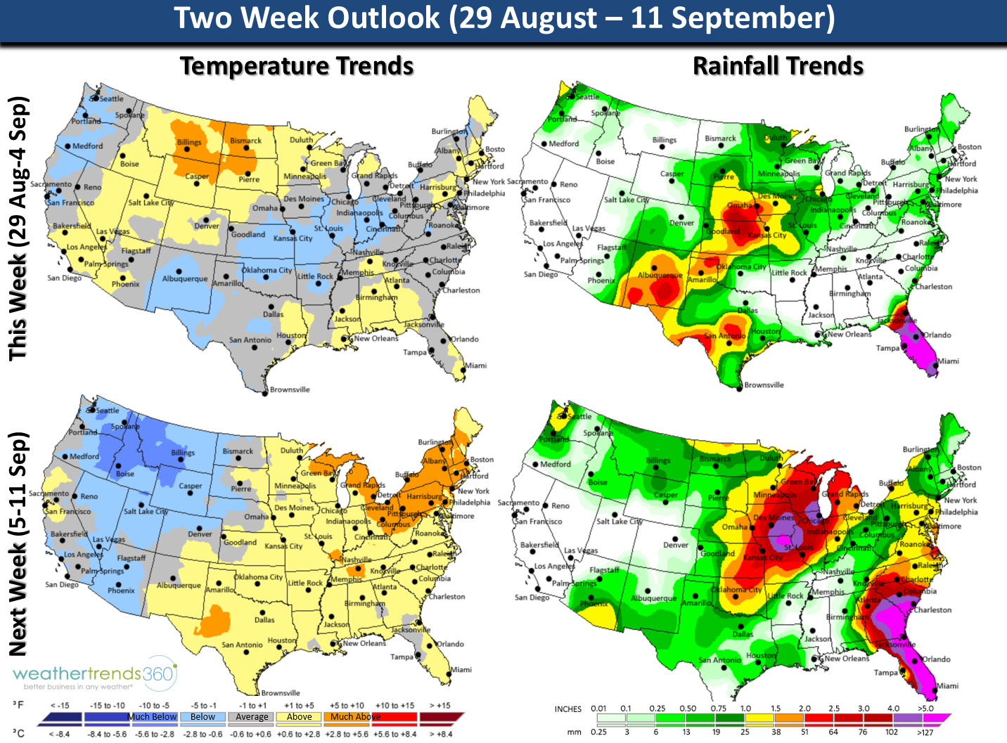
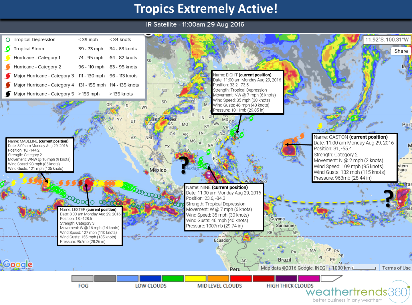
This last week of August (29 Aug - 4 Sep) looks to trend the coolest in 7 years and -1F below average for the U.S. overall making the week the 8th coolest of the past 25 years. Rainfall has abated trending 15% below average and 12th driest of the past 25 years. The tropics haven't been this active in years. The imminent threat this week is Tropical Depression #9 that is likely to become a stronger Tropical Storm meandering in the Gulf of Mexico before recurving back toward North Florida later this week. Some models make this a minimal hurricane. The system off North Carolina likely to also become a Tropical Storm but should recurve out to sea before making landfall while once Major Hurricane Gaston remains a fish storm and weakens. Hawaii should also monitor the two maybe three systems that could come pretty close to the Islands this week and next.

Next week (5-11 Sep) the tropics need to be watched very closely as a system coming off Africa today is currently modeled to take the typical trek across the Atlantic and threaten the entire U.S. East Coast 12 days from now. Way out there but need to watch these storms closely as they typically are the stronger hurricanes and we are entering the historically most active part of the season over the next 30 days. National temperatures trend 4th hottest of the past 25 years (+1.2F above average) while rainfall could be #1 wettest in 25+ years in light of the hurricane threats in the East. Keep in mind the Gulf water temperatures are 86-90F so systems can flare up very quickly leaving little time for preparations!

Visit our Facebook fan page for frequent daily updates or twitter feeds.
Facebookhttps://www.facebook.com/weathertrends360
Twitterhttps://twitter.com/wt360
Have a great week folks!
August 2016will end up as the 3rd hottest in 25+ years for the U.S. overall and hottest since 2011. The Great Lakes, Ohio Valley and Northeast showed the greatest temperature anomalies while the West Coast was also on the warmer than average side. The cool spots were the Rocky Mountain states while the Plains were near average. Hot 90F days were the 5th most in 25+ years for the U.S. overall. Rainfall was the #1 wettest in 25 years for the U.S. overall due in large part to the flooding event in the South Central U.S. into the Southern Midwest.
This last week of August (29 Aug - 4 Sep) looks to trend the coolest in 7 years and -1F below average for the U.S. overall making the week the 8th coolest of the past 25 years. Rainfall has abated trending 15% below average and 12th driest of the past 25 years. The tropics haven't been this active in years. The imminent threat this week is Tropical Depression #9 that is likely to become a stronger Tropical Storm meandering in the Gulf of Mexico before recurving back toward North Florida later this week. Some models make this a minimal hurricane. The system off North Carolina likely to also become a Tropical Storm but should recurve out to sea before making landfall while once Major Hurricane Gaston remains a fish storm and weakens. Hawaii should also monitor the two maybe three systems that could come pretty close to the Islands this week and next.
Next week (5-11 Sep) the tropics need to be watched very closely as a system coming off Africa today is currently modeled to take the typical trek across the Atlantic and threaten the entire U.S. East Coast 12 days from now. Way out there but need to watch these storms closely as they typically are the stronger hurricanes and we are entering the historically most active part of the season over the next 30 days. National temperatures trend 4th hottest of the past 25 years (+1.2F above average) while rainfall could be #1 wettest in 25+ years in light of the hurricane threats in the East. Keep in mind the Gulf water temperatures are 86-90F so systems can flare up very quickly leaving little time for preparations!
Visit our Facebook fan page for frequent daily updates or twitter feeds.
Facebookhttps://www.facebook.com/weathertrends360
Twitterhttps://twitter.com/wt360
Have a great week folks!