Star Date 3 October 2016 Monday
Captain's Log
Happy Monday folks!
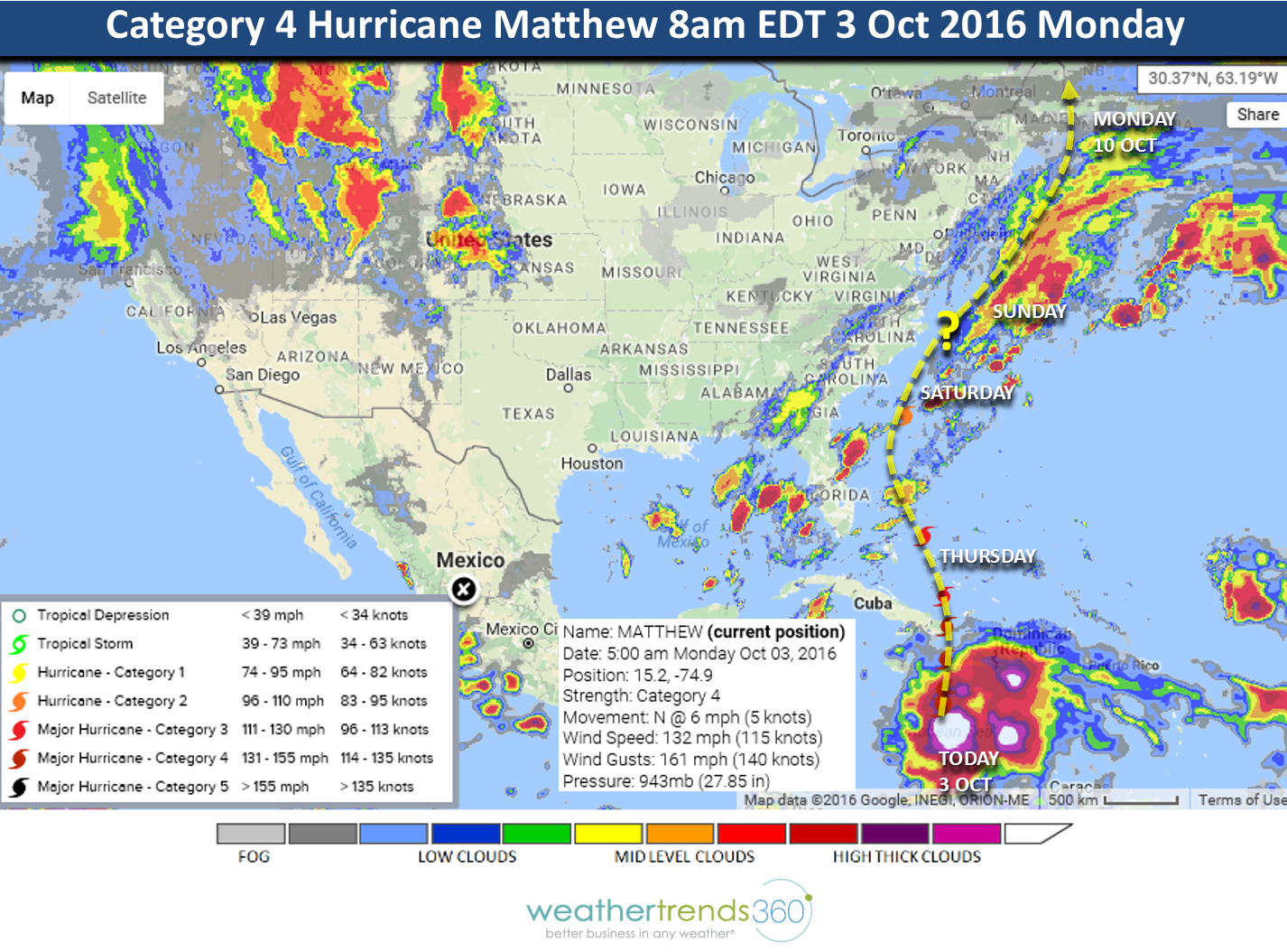
LAST WEEK (26 SEP - 2 OCT): The highlight of course was the development of Major Hurricane Matthew (2nd major hurricane of the season, 14th system of the year) that briefly reached Category 5 status Saturday morning with 160 mph sustained winds. This would make it the first Cat 5 in the Atlantic since Cat 5 Felix Sept 5, 2007 breaking the longest stretch without a Cat 5 on record (165 years). Matthew is also the first Cat 5 to form this far South - the Southernmost Cat 5 since Ivan back in mid Sept 2004. Matthew also appears to be the 2nd strongest October hurricane on record since Wilma set the record in Oct 2005. So a lot of firsts with Matthew.
THIS WEEK (3-9 OCT):The week overall is the warmest in 5 years and wettest in 7 years for the U.S. overall. The wettest areas will be Oklahoma to Wisconsin and the Immediate East Coast. The West starts off very cold for this time of year as a strong cold front moves across the U.S. Out ahead of the front temperatures will be 10-20 degrees above average in the Central U.S. before temperatures plunge some 25 degrees behind the front late this week into the Columbus Day holiday weekend. This front in part will help to steer Matthew up the East Coast over the weekend.

MATTHEW: Currently it's still a strong category 4 storm moving slowly north. This will bring devastation to Haiti, Eastern Cuba and the Bahamas due to the slow movement and prolonged 132 mph sustained winds (gusts to 162 mph) and a huge tidal surge with 30 foot season on top of that. The right front quadrant has the highest surge and strongest winds so extreme Western Haiti (Current track shows the hurricane passing about 90 miles to the West of Port-au-Prince Haiti) and extreme Eastern Cuba to the East of Guantanamo Bay Cuba will be hardest hit on Tuesday and then the Central Bahamas on Wednesday. The flooding/mud slide threat in Haiti could be devastating with upwards of 40" of rain due to the slow movement. The greatest threats to the U.S. are the Outer Banks of North Carolina and Coastal New England late this week into the weekend. But, the entire East Coast will need to monitor this major hurricane as track errors can be 200 miles beyond day 5.
NEXT WEEK (10-16 OCT): The middle October period last year was record warm and driest in 25 years for the U.S. overall; this year is cooler along the East Coast and West Coast while the Central U.S. is the warmest in over 25 years. The wettest areas are in the Pacific Northwest and Middle Atlantic/Southeast. Still need to watch the Caribbean as a few more systems could flare up in October.
For daily updates visit our Facebook and Twitter fan pages.
Have a great and SAFE week and prayers for folks in the path of Matthew.
LAST WEEK (26 SEP - 2 OCT): The highlight of course was the development of Major Hurricane Matthew (2nd major hurricane of the season, 14th system of the year) that briefly reached Category 5 status Saturday morning with 160 mph sustained winds. This would make it the first Cat 5 in the Atlantic since Cat 5 Felix Sept 5, 2007 breaking the longest stretch without a Cat 5 on record (165 years). Matthew is also the first Cat 5 to form this far South - the Southernmost Cat 5 since Ivan back in mid Sept 2004. Matthew also appears to be the 2nd strongest October hurricane on record since Wilma set the record in Oct 2005. So a lot of firsts with Matthew.
THIS WEEK (3-9 OCT):The week overall is the warmest in 5 years and wettest in 7 years for the U.S. overall. The wettest areas will be Oklahoma to Wisconsin and the Immediate East Coast. The West starts off very cold for this time of year as a strong cold front moves across the U.S. Out ahead of the front temperatures will be 10-20 degrees above average in the Central U.S. before temperatures plunge some 25 degrees behind the front late this week into the Columbus Day holiday weekend. This front in part will help to steer Matthew up the East Coast over the weekend.
MATTHEW: Currently it's still a strong category 4 storm moving slowly north. This will bring devastation to Haiti, Eastern Cuba and the Bahamas due to the slow movement and prolonged 132 mph sustained winds (gusts to 162 mph) and a huge tidal surge with 30 foot season on top of that. The right front quadrant has the highest surge and strongest winds so extreme Western Haiti (Current track shows the hurricane passing about 90 miles to the West of Port-au-Prince Haiti) and extreme Eastern Cuba to the East of Guantanamo Bay Cuba will be hardest hit on Tuesday and then the Central Bahamas on Wednesday. The flooding/mud slide threat in Haiti could be devastating with upwards of 40" of rain due to the slow movement. The greatest threats to the U.S. are the Outer Banks of North Carolina and Coastal New England late this week into the weekend. But, the entire East Coast will need to monitor this major hurricane as track errors can be 200 miles beyond day 5.
NEXT WEEK (10-16 OCT): The middle October period last year was record warm and driest in 25 years for the U.S. overall; this year is cooler along the East Coast and West Coast while the Central U.S. is the warmest in over 25 years. The wettest areas are in the Pacific Northwest and Middle Atlantic/Southeast. Still need to watch the Caribbean as a few more systems could flare up in October.
For daily updates visit our Facebook and Twitter fan pages.
Have a great and SAFE week and prayers for folks in the path of Matthew.