Star Date: 6 September 2016 Tuesday
Captain's Log
We hope you had a great Labor Day weekend!
THIS WEEK (6-12 SEP): Tropical Storm Hermine continues to meander off the Northeast coast after ruining the holiday weekend with waves, rip tides keeping folks out of the water. Fortunately she never made landfall and will disintegrate midweek.
September started off on the cool side but now a warming trend is returning. Nationally temperatures will trend the 3rd warmest of the past 25 years and 7th wettest over the next 7 days. The hot spot is the Northeast while the Northern Rocky Mountains are the cool spot. The remnants of Hurricane Newton off Mexico will bring flash flooding and upwards of 4" of rain to Southern Arizona and Southern New Mexico this week and then into the Central U.S. with 4-6" for Kansas and Missouri.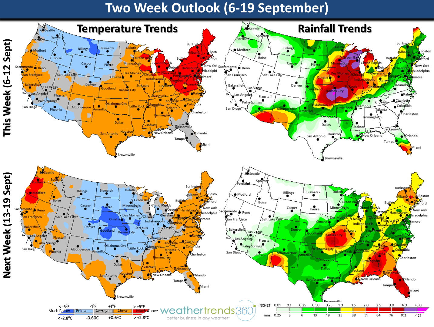 NEXT WEEK (13-19 SEPT): Nationally temps are a bit cooler trending near average (13th coolest of the past 25 years) while rainfall remains 7th wettest of the past 25 years. The East and West Coasts remain the warm spots while more Fall-like weather moves into the Central U.S. More heavy rain for KS-MO with another 3" of rain. Need to watch the tropics as there are at least 5 systems moving off Africa over the next couple weeks and these storms can flare up quickly as they head in the direction of the Caribbean and U.S.
We hope you have a great week! For daily updates visit us on Facebook and twitter.
THIS WEEK (6-12 SEP): Tropical Storm Hermine continues to meander off the Northeast coast after ruining the holiday weekend with waves, rip tides keeping folks out of the water. Fortunately she never made landfall and will disintegrate midweek.
September started off on the cool side but now a warming trend is returning. Nationally temperatures will trend the 3rd warmest of the past 25 years and 7th wettest over the next 7 days. The hot spot is the Northeast while the Northern Rocky Mountains are the cool spot. The remnants of Hurricane Newton off Mexico will bring flash flooding and upwards of 4" of rain to Southern Arizona and Southern New Mexico this week and then into the Central U.S. with 4-6" for Kansas and Missouri.
NEXT WEEK (13-19 SEPT): Nationally temps are a bit cooler trending near average (13th coolest of the past 25 years) while rainfall remains 7th wettest of the past 25 years. The East and West Coasts remain the warm spots while more Fall-like weather moves into the Central U.S. More heavy rain for KS-MO with another 3" of rain. Need to watch the tropics as there are at least 5 systems moving off Africa over the next couple weeks and these storms can flare up quickly as they head in the direction of the Caribbean and U.S.We hope you have a great week! For daily updates visit us on Facebook and twitter.