Star Date 8 November 2017 Wednesday
Captain's Log
Wednesday 8 Nov 2017 Update:
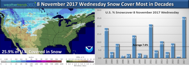
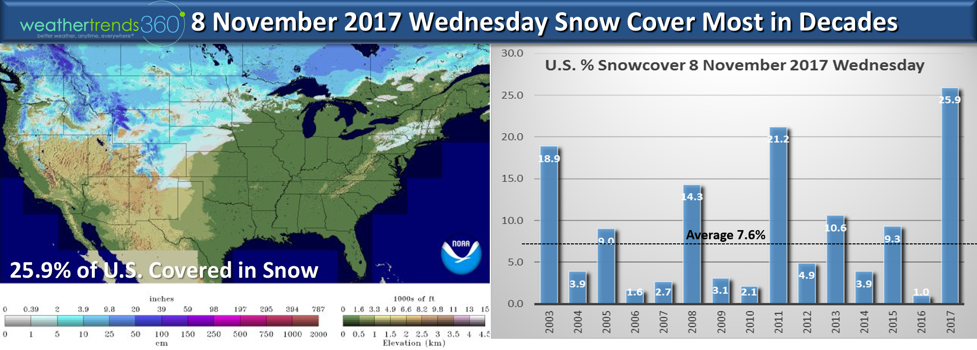
We had our first snowflakes of the season outside wt360 headquarters in Bethlehem, PA yesterday. Accumulating snow just to our West and North. Nearly 26% of the U.S. is covered in snow which is a near record for this early in the season. Last year was record low with only 1% and average is 7.6%. CLICK ON IMAGES FOR LARGER VIEW
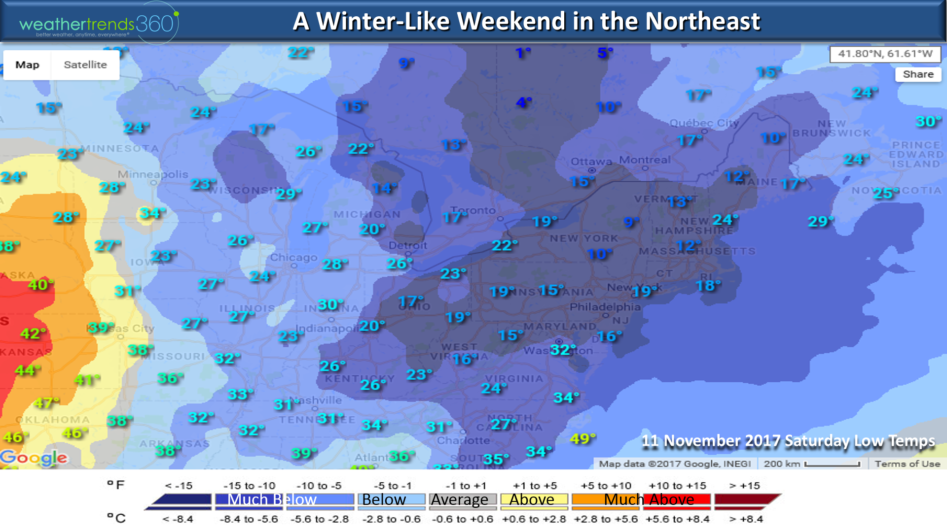
Veteran's Day weekend is going to feel like the heart of Winter as an Arctic blast right out of the North Pole invades Eastern Canada and the Northeast U.S. with the coldest 2nd week of November in over 30 years.
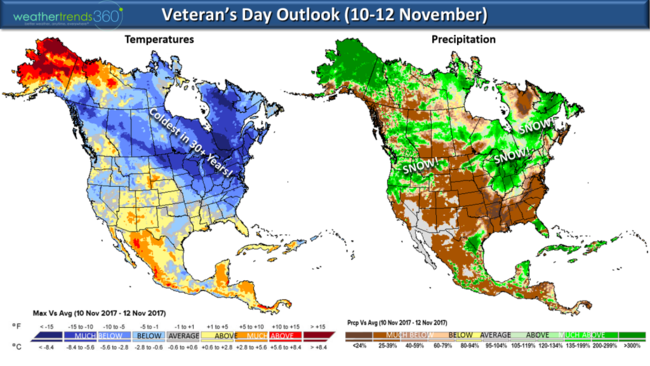
Low temperatures in the single digits and teens Saturday morning are more typical of January, not early November.

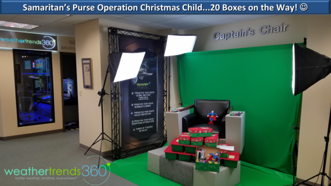
A big THANK YOU to wt360 employees and especially Christine McKnight for helping us fill 20 Operation Christmas Child boxes filled with goodies for kids all over the world along with $1,200. There's still time if you want to help this wonderful organization that has also been instrumental in on-going hurricane disaster relief efforts as well. Samaritan's Purse Operation Christmas Child:https://www.samaritanspurse.org/what-we-do/operation-christmas-child/
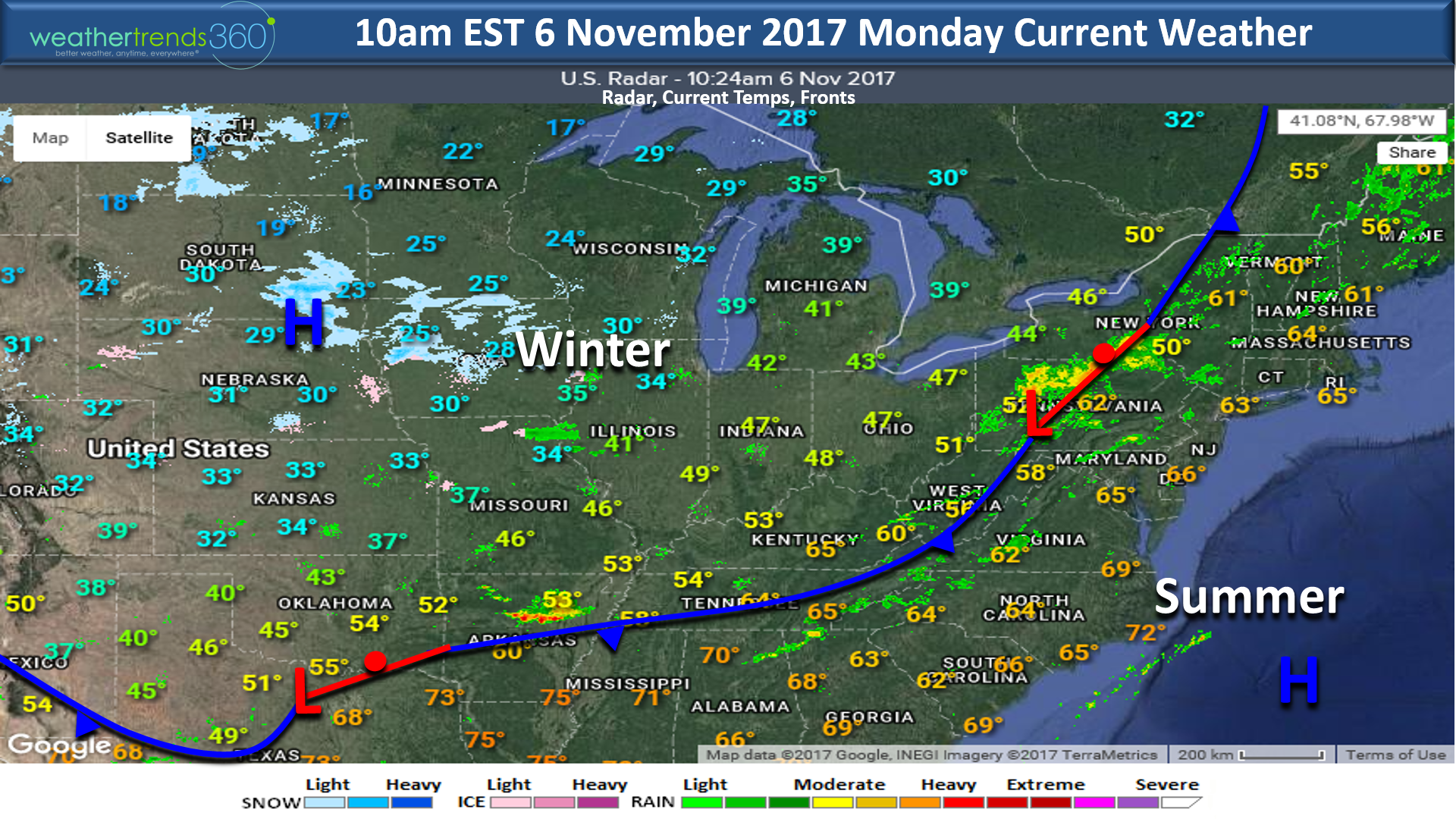
Happy Monday (6 Nov 2017)! :) Not happy about the sun setting today at 4:52pm in Bethlehem, PA! :(
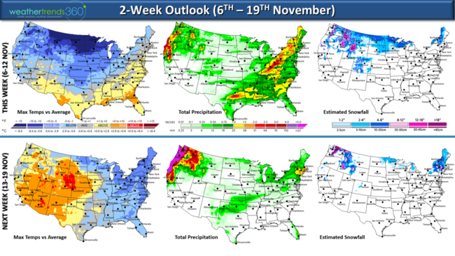
Summer is about to exit the Southeast Coast as a strong cold front is ushering in the coldest air of the season for much of the country. The Northeast will have about 8 days of below average high temperatures with a particularly cold late week period so enjoy the last bit of milder temps this morning. It's snowing again in the Heartland where it's a wholesale change from this time last year when we had a record hot November. CLICK ON IMAGES FOR LARGER VIEW.

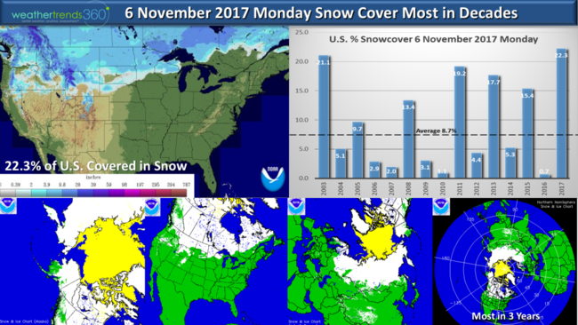
National snow cover continues to be polar opposite last year with 22.3% of the U.S. now covered in snow - the most in decades. This time last year, record low snow cover (0.7%) in the U.S. For the Northern Hemisphere, snow cover continues to be above average and 7.3% more than last year. For North America, snow cover is at levels we don't normally see until late November, most in 12 years. This is one of many signs that the weather pattern this year is nothing like last year so get ready for Winter! Canada is already covered in snow so this will allow Arctic air to stay cold as it heads into the U.S. in the weeks and months ahead.
The next two weeks will be a shock after a mild October in the Northeast but this is just a sign of things to come this Winter!!! Very likely the higher terrain of New England see their first more significant snows of the season as the pattern flip flops a bit with the colder weather slated for the East while the West warms up. Veterans dayweekend(10th - 12th) in the Northeast will feel downright frigid with the coldest conditions in 21 year with widespread very hard freezes in the teens and low 20s!
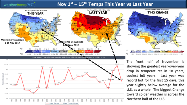
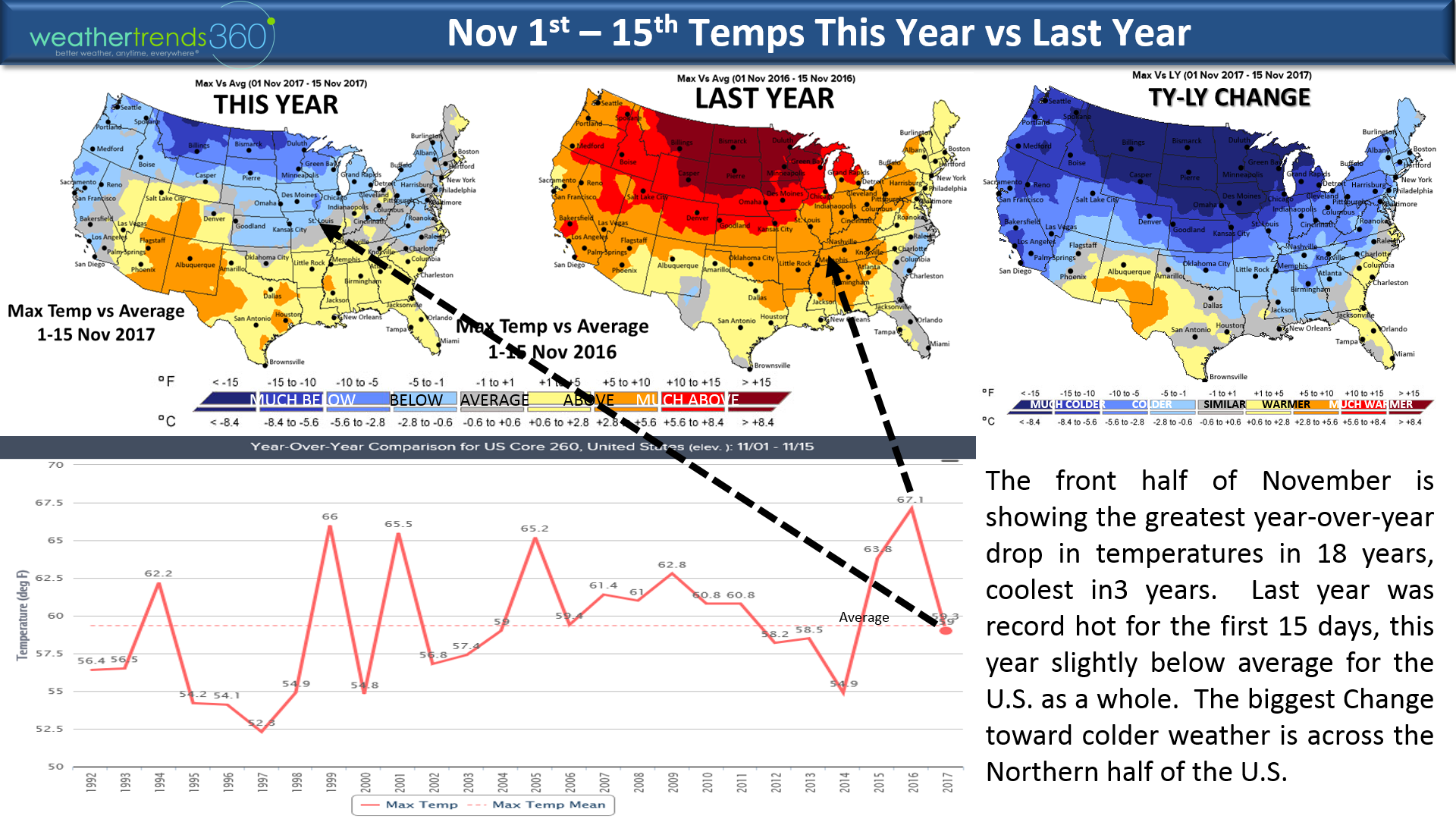
The front half of November is dramatically colder than last year for 80% of the U.S. making a complete flip from a year ago when we had record hot weather across most of the country. Pretty amazing just how opposite the temps are as you see it was cold this time last year along the Southeast coast and SW Texas and ironically those are the two areas that are much warmer this year.
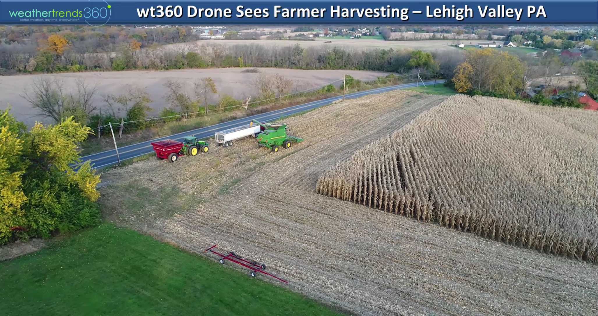
We had the wt360 drone up over the weekend with local farmers rushing to harvest their crops. wt360 Ag customers will be receiving a complete Winter through Fall 2018 outlook video early this week so check your email for that.

We hope you have a great week and for daily updates visit us on Facebook and Twitter.
- Captain Kirk out.
We had our first snowflakes of the season outside wt360 headquarters in Bethlehem, PA yesterday. Accumulating snow just to our West and North. Nearly 26% of the U.S. is covered in snow which is a near record for this early in the season. Last year was record low with only 1% and average is 7.6%. CLICK ON IMAGES FOR LARGER VIEW
Veteran's Day weekend is going to feel like the heart of Winter as an Arctic blast right out of the North Pole invades Eastern Canada and the Northeast U.S. with the coldest 2nd week of November in over 30 years.
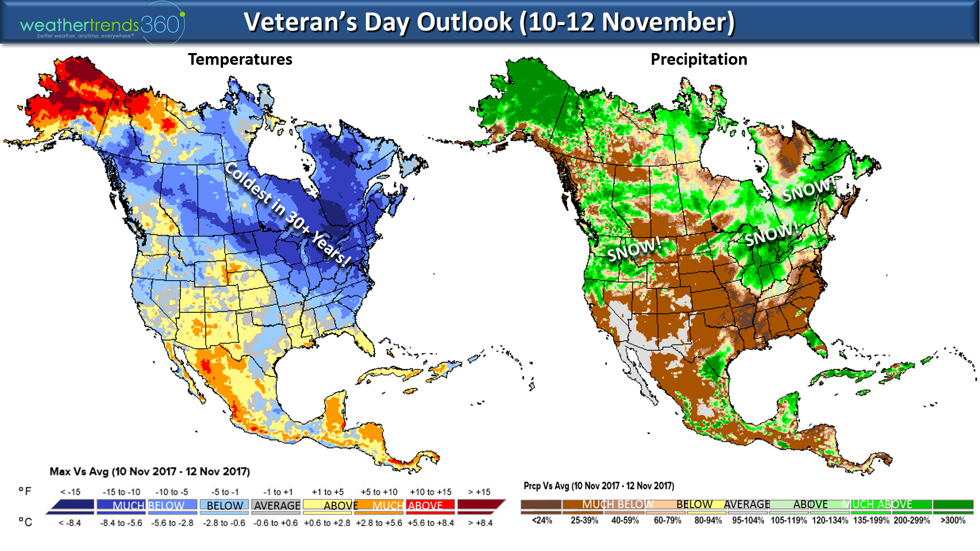
Low temperatures in the single digits and teens Saturday morning are more typical of January, not early November.
A big THANK YOU to wt360 employees and especially Christine McKnight for helping us fill 20 Operation Christmas Child boxes filled with goodies for kids all over the world along with $1,200. There's still time if you want to help this wonderful organization that has also been instrumental in on-going hurricane disaster relief efforts as well. Samaritan's Purse Operation Christmas Child:https://www.samaritanspurse.org/what-we-do/operation-christmas-child/

Happy Monday (6 Nov 2017)! :) Not happy about the sun setting today at 4:52pm in Bethlehem, PA! :(
Summer is about to exit the Southeast Coast as a strong cold front is ushering in the coldest air of the season for much of the country. The Northeast will have about 8 days of below average high temperatures with a particularly cold late week period so enjoy the last bit of milder temps this morning. It's snowing again in the Heartland where it's a wholesale change from this time last year when we had a record hot November. CLICK ON IMAGES FOR LARGER VIEW.
National snow cover continues to be polar opposite last year with 22.3% of the U.S. now covered in snow - the most in decades. This time last year, record low snow cover (0.7%) in the U.S. For the Northern Hemisphere, snow cover continues to be above average and 7.3% more than last year. For North America, snow cover is at levels we don't normally see until late November, most in 12 years. This is one of many signs that the weather pattern this year is nothing like last year so get ready for Winter! Canada is already covered in snow so this will allow Arctic air to stay cold as it heads into the U.S. in the weeks and months ahead.

The next two weeks will be a shock after a mild October in the Northeast but this is just a sign of things to come this Winter!!! Very likely the higher terrain of New England see their first more significant snows of the season as the pattern flip flops a bit with the colder weather slated for the East while the West warms up. Veterans dayweekend(10th - 12th) in the Northeast will feel downright frigid with the coldest conditions in 21 year with widespread very hard freezes in the teens and low 20s!

The front half of November is dramatically colder than last year for 80% of the U.S. making a complete flip from a year ago when we had record hot weather across most of the country. Pretty amazing just how opposite the temps are as you see it was cold this time last year along the Southeast coast and SW Texas and ironically those are the two areas that are much warmer this year.
We had the wt360 drone up over the weekend with local farmers rushing to harvest their crops. wt360 Ag customers will be receiving a complete Winter through Fall 2018 outlook video early this week so check your email for that.
We hope you have a great week and for daily updates visit us on Facebook and Twitter.
- Captain Kirk out.