Star Date 8 October 2018 Monday
Captain's Log
9am EDT 10 Oct 2018 Wednesday video update on Cat 4 Hurricane Michael.
8 Oct 2018 Happy Monday folks! :)
Another land falling hurricane on the way for the Panhandle of Florida midweek. This system is much stronger than T.S. Alberto back in May so take this seriously. CLICK ON IMAGES FOR LARGER VIEW.
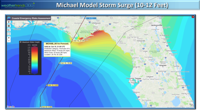
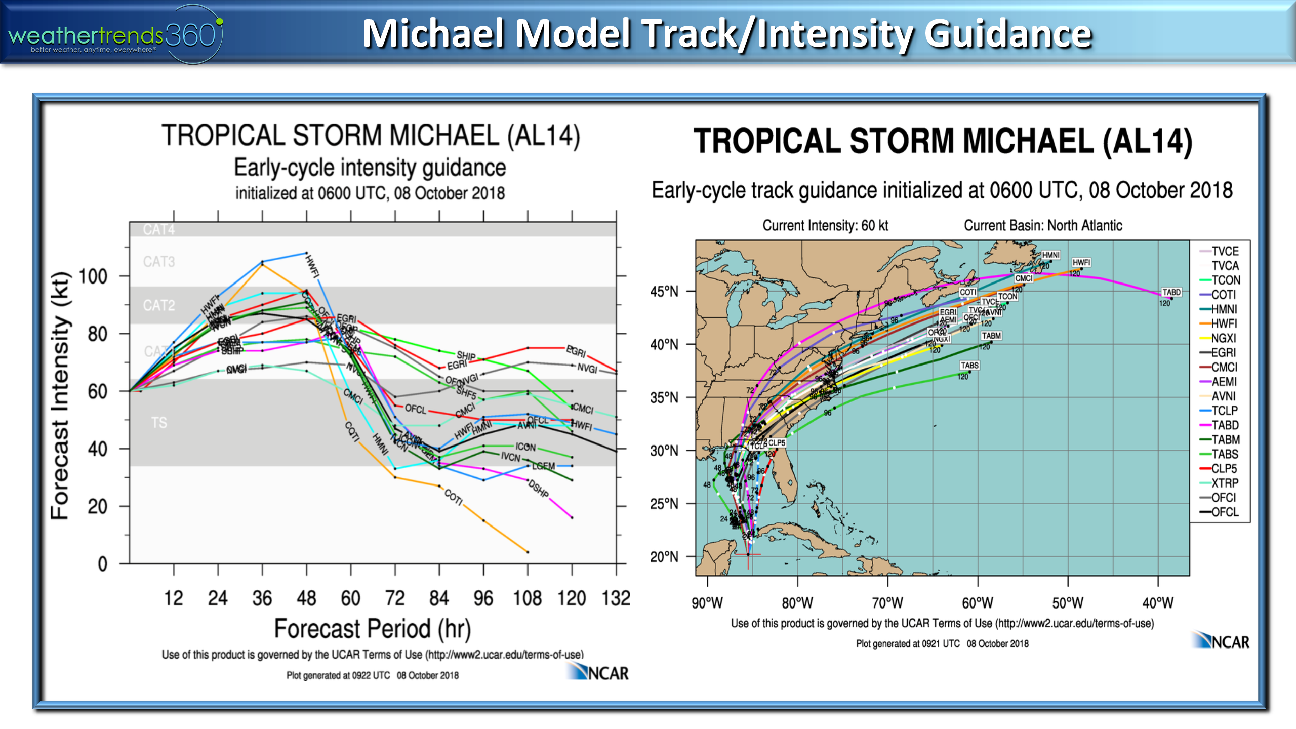
The model guidance suggests a stronger hurricane is likely on the high end of Cat 1 all the way up to a Cat 3 with landfall Wednesday afternoon near Apalachicola Bay. From there it races off the East Coast so the flooding will not be on par with Florence but it will bring heavier 3-6"+ rainfall totals from FL to VA. This is the 13th named storm for the 2018 season, and 14th system...an above average year as expected.

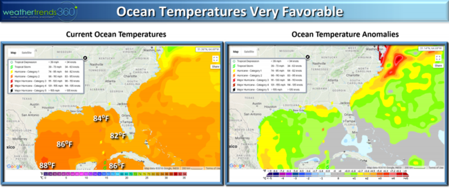
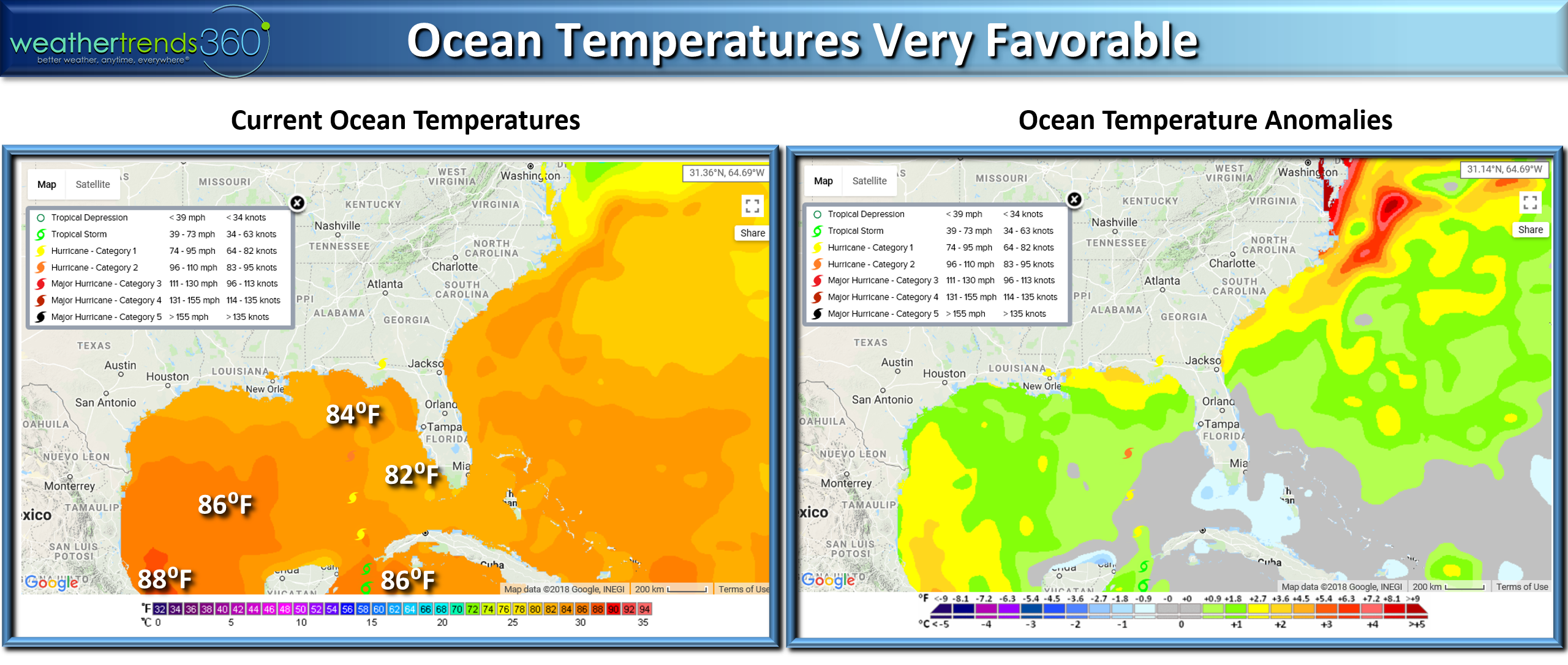
Water temperatures are plenty warm enough in the middle 80s with weakening wind shear for a stronger hurricane. Storm surge will be in the 8-12 feet range with waves on top of that.
Waves will top 25-30 feet just off the Coast on Wednesday.
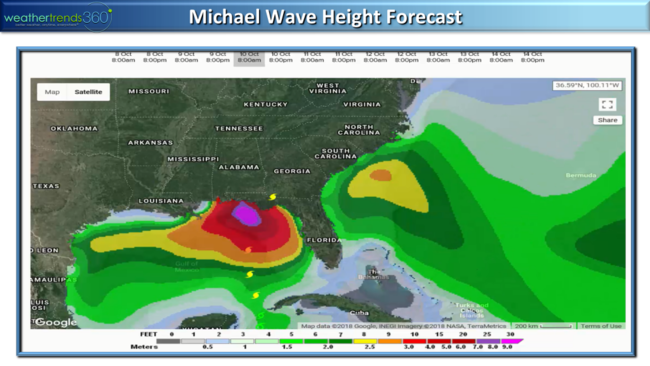
Combined with the storm surge, waves are on top of the surge, there will be a 2-story high wall of water in Apalachicola Bay. Be safe!!!
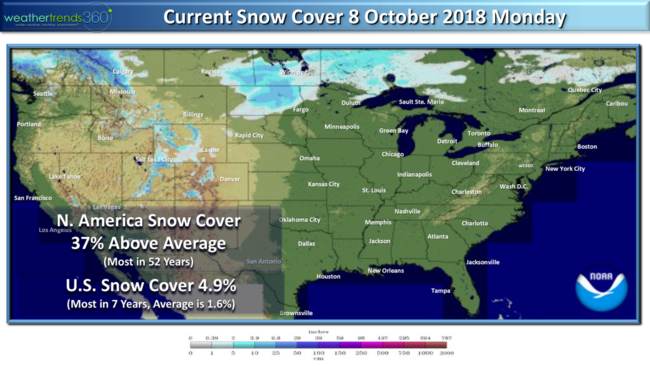
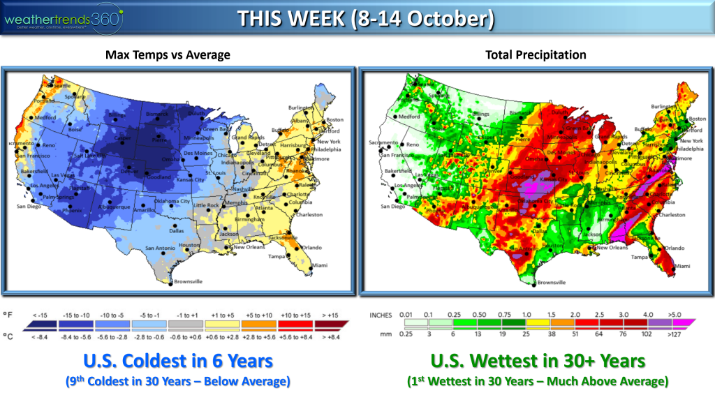
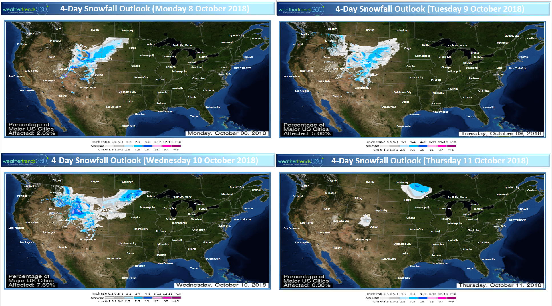
In the Western half of the country it's Winter-like with 4.9% of the U.S. already blanketed in snow, that's early. Typically we'd only expect 1.6% snow cover so we're off to a decent start. Looking across North America, snow cover is off the charts trending 37% above average and the most in over 52 years! A sign of things to come for this Winter. Also a lot of early snow in Eastern Siberia so these are all signs of a very cold and snowy Winter in the Eastern half of the U.S.!
Another light snow event will move out of the Rockies this week into the Upper Plains with light to moderate snow.

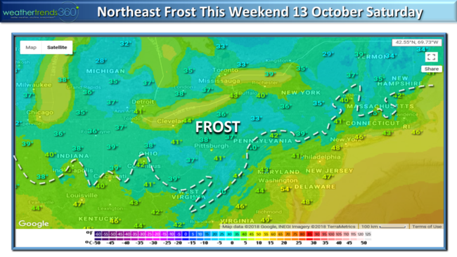
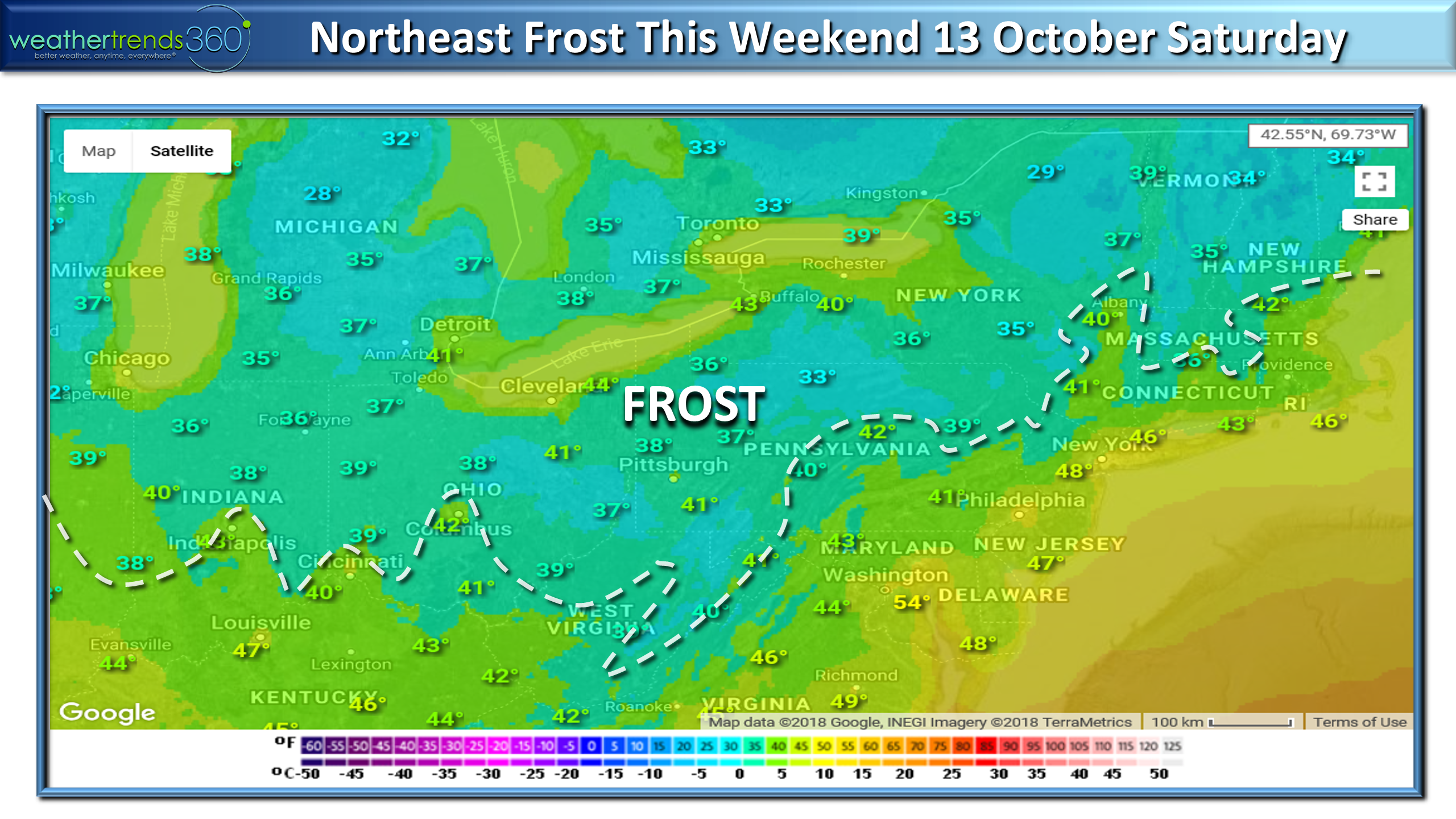
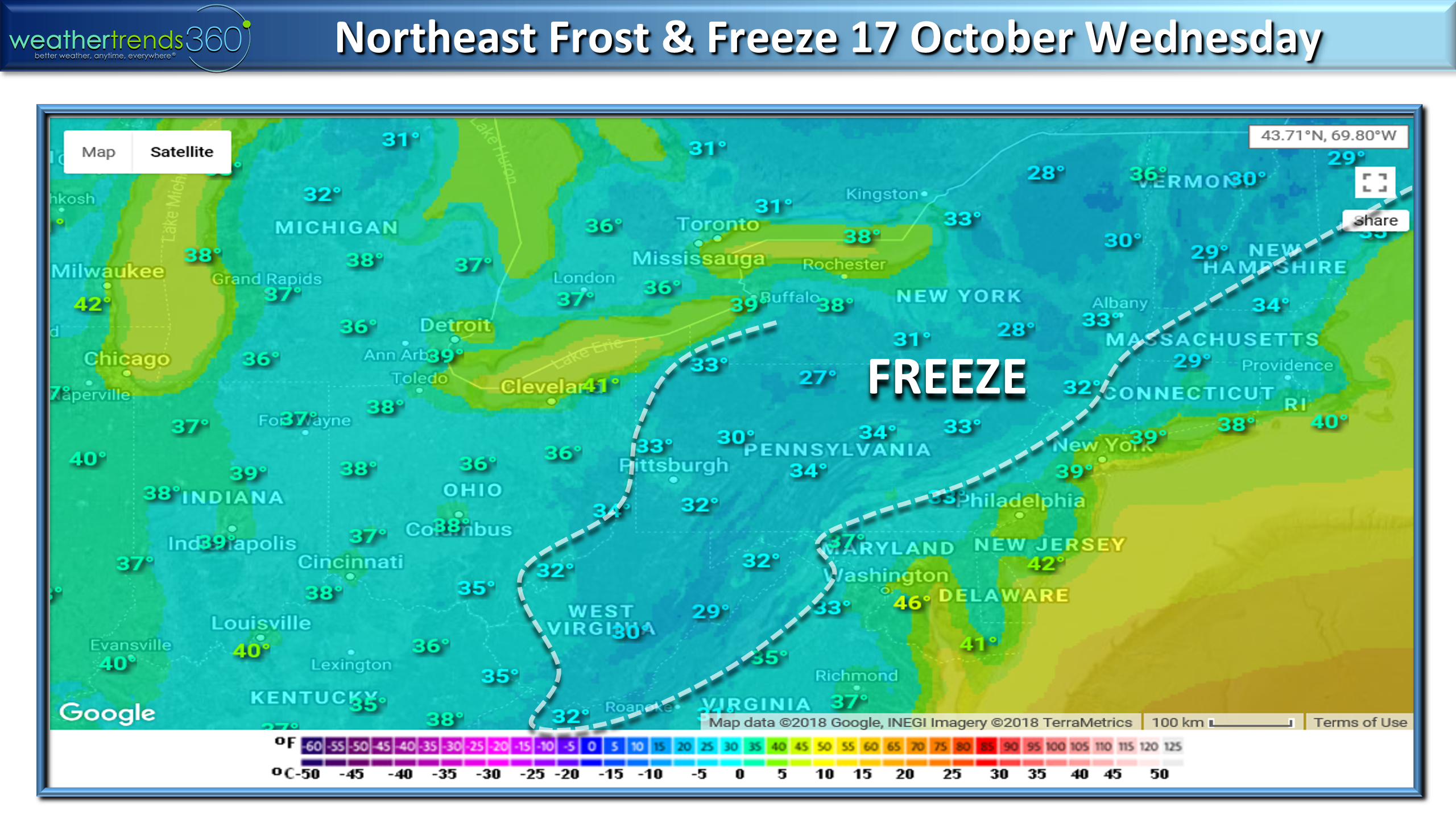
Matthew will exit the East Coast as a strong cold front ushers in the coldest air of the season for the South and East with the first frost likely in the Ohio Valley and interior Northeast Saturday.
After 80s yesterday, this 50 degree plunge in temperatures will be noticeable.
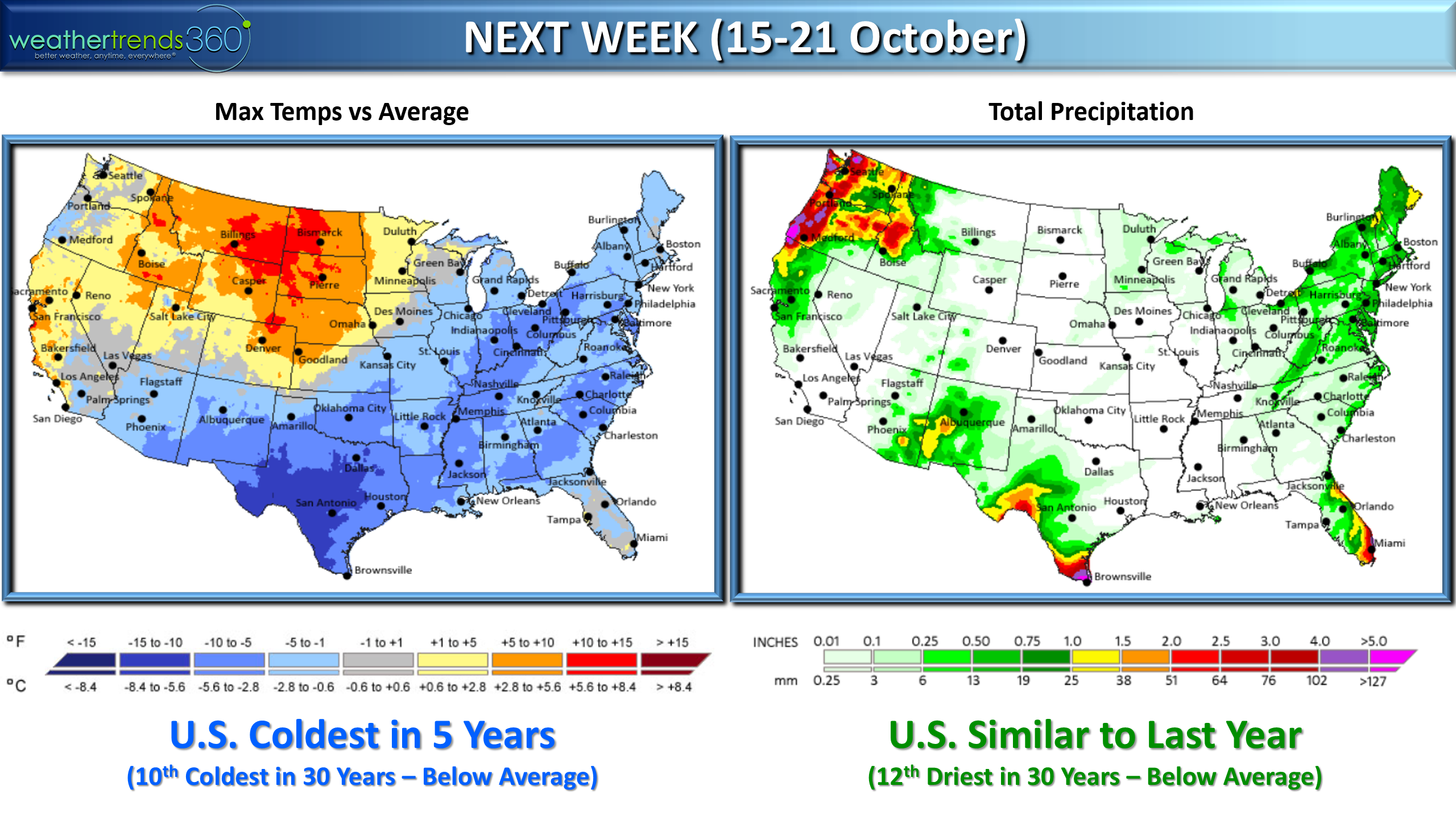
Next week the South and East is the cold spot with the nation drying out a bit.

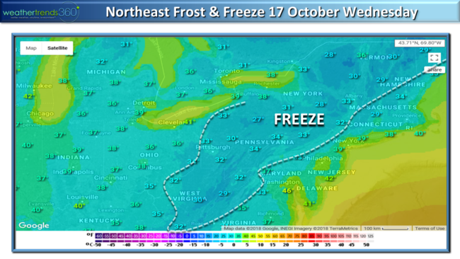
The first FREEZE of the season likely for many areas in the Northeast by the middle of next week.
On Thursday we'll be live on RFDTV at 1:30pm EDT to talk about our Winter outlook.

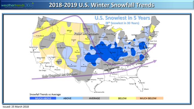
Overall we have it the coldest and snowiest in 5 years with an exciting Winter if you like bigger snow storms from the Heartland to the Middle Atlantic/East Coast.
For now that's all we have to say about that...tune in to Direct TV channel 345 or Dish channel 231 as we discuss the Winter outlook and our FarmCast service for farmers anywhere in the world.

Have a great week folks and follow us on social media for daily updates.Facebook,Twitter,YouTube,PinterestandLinkedin
- Captain Kirk out.
8 Oct 2018 Happy Monday folks! :)
Another land falling hurricane on the way for the Panhandle of Florida midweek. This system is much stronger than T.S. Alberto back in May so take this seriously. CLICK ON IMAGES FOR LARGER VIEW.
The model guidance suggests a stronger hurricane is likely on the high end of Cat 1 all the way up to a Cat 3 with landfall Wednesday afternoon near Apalachicola Bay. From there it races off the East Coast so the flooding will not be on par with Florence but it will bring heavier 3-6"+ rainfall totals from FL to VA. This is the 13th named storm for the 2018 season, and 14th system...an above average year as expected.
Water temperatures are plenty warm enough in the middle 80s with weakening wind shear for a stronger hurricane. Storm surge will be in the 8-12 feet range with waves on top of that.
Waves will top 25-30 feet just off the Coast on Wednesday.

Combined with the storm surge, waves are on top of the surge, there will be a 2-story high wall of water in Apalachicola Bay. Be safe!!!

In the Western half of the country it's Winter-like with 4.9% of the U.S. already blanketed in snow, that's early. Typically we'd only expect 1.6% snow cover so we're off to a decent start. Looking across North America, snow cover is off the charts trending 37% above average and the most in over 52 years! A sign of things to come for this Winter. Also a lot of early snow in Eastern Siberia so these are all signs of a very cold and snowy Winter in the Eastern half of the U.S.!

Another light snow event will move out of the Rockies this week into the Upper Plains with light to moderate snow.
Matthew will exit the East Coast as a strong cold front ushers in the coldest air of the season for the South and East with the first frost likely in the Ohio Valley and interior Northeast Saturday.
After 80s yesterday, this 50 degree plunge in temperatures will be noticeable.
Next week the South and East is the cold spot with the nation drying out a bit.
The first FREEZE of the season likely for many areas in the Northeast by the middle of next week.
On Thursday we'll be live on RFDTV at 1:30pm EDT to talk about our Winter outlook.

Overall we have it the coldest and snowiest in 5 years with an exciting Winter if you like bigger snow storms from the Heartland to the Middle Atlantic/East Coast.

For now that's all we have to say about that...tune in to Direct TV channel 345 or Dish channel 231 as we discuss the Winter outlook and our FarmCast service for farmers anywhere in the world.

Have a great week folks and follow us on social media for daily updates.Facebook,Twitter,YouTube,PinterestandLinkedin
- Captain Kirk out.