Star Date 8 September 2017 Friday
Captain's Log
11 am EDT Update on IRMA
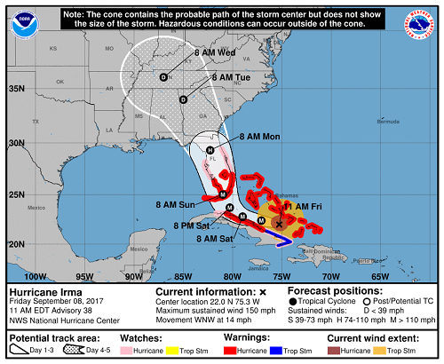
As of 11 am this morning, Major Hurricane Irma was a dangerous category 4 storm with maximum sustained winds of 150 mph with higher gusts. Hurricane-force winds are extending farther than they did 24 hours ago and are now out up to 70 miles from the center and tropical storm-force winds extend outward up to 185 miles. Irma is located approximate 405 miles southeast of Miami, FL and will move between the central Bahamas and the north coast of Cuba today.
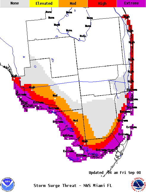
Over the next 24-36 hours, Irma will continue on a west-northwest track going over very warm waters between Florida and the Bahamas. This energy will help to maintain Irma as a major hurricane up at least through landfall (likely Sunday morning) and we think Irma will still be a powerful category 4 storm at that time. After 36 hours, the storm will make the all-important turn in track to a more north-northwest direction pointed towards Florida; exactly when and where this turn occurs will make a huge difference in where Irma makes landfall. In the past 24 hours we've seen both the European model and the U.S. GFS model shift the track of Irma west which means we'll likely have hurricane-force winds across the southern peninsula with Miami and West Palm Beach in the dangerous right-front quadrant of the hurricane with devastating results. Irma is a much larger storm in size than Andrew (1992) and Charley (2004), so a much wider area of major impacts and large surge is expected. Storm surge could be up to 15 ft with 30 ft waves on top of that around the southern tip of Florida from about just south of Naples around to Homestead with serious concerns for Miami as well.
Irma should weaken a bit after making landfall and may lose 'major' status by the time she makes her closest approach to Orlando. However, she will still be a dangerous storm at this point with widespread wind gusts in excess of 100 mph. We cannot stress enough how dangerous this storm will be for the entire Florida peninsula. Once Irma ravages Florida, she will move out of the state Monday and continue heading in a northwesterly direction. At this time it appears the center of Irma will track up across Georgia or South Carolina as a tropical storm and eventually up into the Tennessee Valley as a tropical depression. Thereafter, Irma will quickly degenerate, however, there is a threat of inland flooding, especially across the Smokey Mountains. Again, the forecast track depends heavily on where Irma makes the turn towards Florida. There is still a chance that she could move up closer to the Carolinas which would increase the wind and flooding threat there.
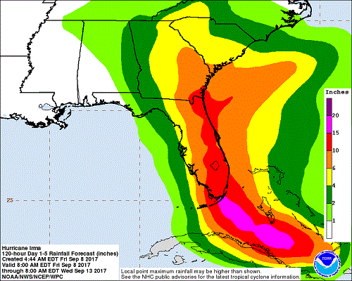
Rainfall will not be anywhere near as bad as Harvey since Irma will be moving rather quickly once she makes the right turn up into Florida. Widespread 5" rain totals are expected from Florida to Georgia and the Carolinas. There could be some isolated rainfall totals nearing a foot across this area, especially in Florida. Inland flooding is possible.
Preparations and evacuations along the Florida peninsula should wrap up today. Tomorrow will be too late to batten down the hatches as tropical storm-force winds overspread the state with hurricane-force winds arrive later in the day. Please follow all evacuation orders, don't take chances with this storm!
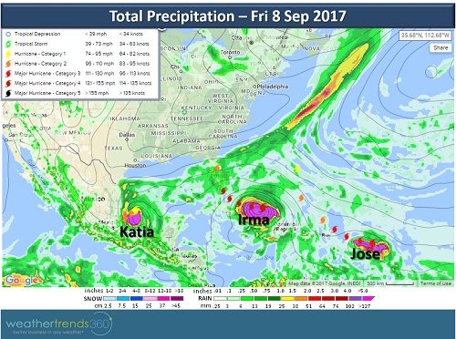
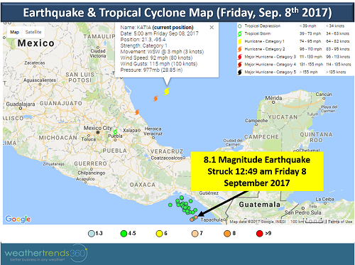
As if 1 major hurricane wasn't enough, we now have Major Hurricane Jose which is a category 4 storm as of 11 am this morning with maximum sustained winds of 150 mph. Unfortunately, it looks as though Jose will brush some of the Leeward Islands this weekend, including Barbados, that were absolutely devastated by Irma earlier this week. We also have category 2 storm Katia in the Bay of Campeche. She will make landfall in eastern Mexico over the weekend with over a foot of rain in some areas which will cause flash flooding and mudslides, especially in areas of mountainous terrain.
While Mexico is keeping an eye on Katia, they unfortunately are dealing with another major disaster that occurred overnight. A massive 8.1 magnitude earthquake (preliminary), the strongest to hit Mexico in 100 years, struck off the southern coast of Mexico turning buildings close to the epicenter to rubbleand killing dozens of people, though that toll is expected to rise. The tremors were felt as far away as Mexico City (600 miles away) causing sporadic power outages. The quake touched off tsunami warnings along the Pacific coasts of Guatemala, El Salvador, Costa Rica, Nicaragua, Panama, and Honduras. Some larger waves were observed in parts of Mexico.
As of 11 am this morning, Major Hurricane Irma was a dangerous category 4 storm with maximum sustained winds of 150 mph with higher gusts. Hurricane-force winds are extending farther than they did 24 hours ago and are now out up to 70 miles from the center and tropical storm-force winds extend outward up to 185 miles. Irma is located approximate 405 miles southeast of Miami, FL and will move between the central Bahamas and the north coast of Cuba today.
Over the next 24-36 hours, Irma will continue on a west-northwest track going over very warm waters between Florida and the Bahamas. This energy will help to maintain Irma as a major hurricane up at least through landfall (likely Sunday morning) and we think Irma will still be a powerful category 4 storm at that time. After 36 hours, the storm will make the all-important turn in track to a more north-northwest direction pointed towards Florida; exactly when and where this turn occurs will make a huge difference in where Irma makes landfall. In the past 24 hours we've seen both the European model and the U.S. GFS model shift the track of Irma west which means we'll likely have hurricane-force winds across the southern peninsula with Miami and West Palm Beach in the dangerous right-front quadrant of the hurricane with devastating results. Irma is a much larger storm in size than Andrew (1992) and Charley (2004), so a much wider area of major impacts and large surge is expected. Storm surge could be up to 15 ft with 30 ft waves on top of that around the southern tip of Florida from about just south of Naples around to Homestead with serious concerns for Miami as well.
Irma should weaken a bit after making landfall and may lose 'major' status by the time she makes her closest approach to Orlando. However, she will still be a dangerous storm at this point with widespread wind gusts in excess of 100 mph. We cannot stress enough how dangerous this storm will be for the entire Florida peninsula. Once Irma ravages Florida, she will move out of the state Monday and continue heading in a northwesterly direction. At this time it appears the center of Irma will track up across Georgia or South Carolina as a tropical storm and eventually up into the Tennessee Valley as a tropical depression. Thereafter, Irma will quickly degenerate, however, there is a threat of inland flooding, especially across the Smokey Mountains. Again, the forecast track depends heavily on where Irma makes the turn towards Florida. There is still a chance that she could move up closer to the Carolinas which would increase the wind and flooding threat there.
Rainfall will not be anywhere near as bad as Harvey since Irma will be moving rather quickly once she makes the right turn up into Florida. Widespread 5" rain totals are expected from Florida to Georgia and the Carolinas. There could be some isolated rainfall totals nearing a foot across this area, especially in Florida. Inland flooding is possible.
Preparations and evacuations along the Florida peninsula should wrap up today. Tomorrow will be too late to batten down the hatches as tropical storm-force winds overspread the state with hurricane-force winds arrive later in the day. Please follow all evacuation orders, don't take chances with this storm!
As if 1 major hurricane wasn't enough, we now have Major Hurricane Jose which is a category 4 storm as of 11 am this morning with maximum sustained winds of 150 mph. Unfortunately, it looks as though Jose will brush some of the Leeward Islands this weekend, including Barbados, that were absolutely devastated by Irma earlier this week. We also have category 2 storm Katia in the Bay of Campeche. She will make landfall in eastern Mexico over the weekend with over a foot of rain in some areas which will cause flash flooding and mudslides, especially in areas of mountainous terrain.
While Mexico is keeping an eye on Katia, they unfortunately are dealing with another major disaster that occurred overnight. A massive 8.1 magnitude earthquake (preliminary), the strongest to hit Mexico in 100 years, struck off the southern coast of Mexico turning buildings close to the epicenter to rubbleand killing dozens of people, though that toll is expected to rise. The tremors were felt as far away as Mexico City (600 miles away) causing sporadic power outages. The quake touched off tsunami warnings along the Pacific coasts of Guatemala, El Salvador, Costa Rica, Nicaragua, Panama, and Honduras. Some larger waves were observed in parts of Mexico.