The Santa Ana Winds Explained
Did You Know?
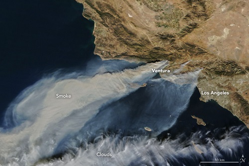
Santa has already come to town for southern California, but it's not the rosy cheeked, gift-bearing Santa we wanted this December. The Santa Ana winds have been blasting through southern California this week bringing wind gusts up to a destructive 90 mph along with very low humidity. These conditions have combined to bring extremely critical fire weather conditions to the region with several fires currently burning. Thousands of acres have already been torched and the situation doesn't look to improve anytime soon as dangerous conditions will persist through the end of the week. The image below is provided by NASA and shows smoke from the southern California fires as detected by satellites on December 5th, 2017.
So what exactly are these Santa Ana winds? It's a weather phenomenon specific to southern California named for the Santa Ana Valley through which some of the strongest winds blow. Although the Santa Ana winds are specific to southern California, other areas of the world are prone to similar wind events but they have different names like the Foehn (name used primarily in the U.K.) or Chinook winds (name used primarily in the Rocky Mountains).
Santa Ana winds typically bring strong, hot, and dust-bearing winds along the Pacific Coast near Los Angeles from inland desert regions. California is, of course, no stranger to wildfires, in fact, they have 2 wildfire seasons each year, one in the Summer and one that generally starts in mid to late Autumn. Santa Ana winds are most prominent in the Autumn fire season, generally between October and February.
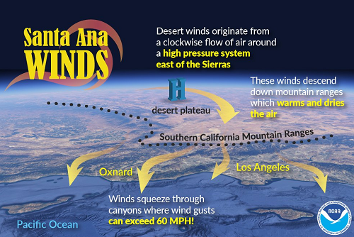
The Santa Ana winds typically originates from a high pressure system that develops east of the Sierra Mountains and west of the Rocky Mountains in the Great Basin that steers desert winds in the direction of southern California. A pressure gradient, which is a change in pressure measured over a given distance, between the Great Basin and the Pacific Ocean helps to produce the strong winds and they gain heat as they descend down the mountain ranges through a process known as compressional warming. Not only does this process warm the air, but it also lowers the relative humidity which, in turn, helps to dry out vegetation, in other words, it primes fire fuel for easy ignition. However, one important distinction about Santa Ana winds as compared to the Foehn or Chinook winds is that oftentimes, the air is already warm and dry before descending the mountains given its desert origins. This helpful graphic below from the National Oceanic and Atmospheric Administration helps to visualize the mechanics behind the Santa Ana winds.
The winds are squeezed through the various canyons across southern California which helps to increase wind speeds as the air is forced through narrower spaces. The winds usually channel through the Santa Clara River Valley in Venture County, where we've seen some big fires this week, or through the San Fernando Valley where it splits again. The wind then flows through Simi Valley in Venture County and through the passes and canyons of the Santa Monica Mountains and Malibu, or through the Los Angeles Basin itself.
Winds during a Santa Ana wind event can top 100 mph and temperatures can soar into the triple digits as well. Hot, dry, and windy conditions drive existing wildfires quickly across the landscape burning thousands of acres per hour. While Santa Ana is responsible for quickly spreading wildfires, the fires themselves must have some sort of spark to get going. Wildfire ignition is often found to be human-caused with things like unattended campfires, negligent debris burning, carelessly discarded cigarettes, and arson as common culprits. However, Mother Nature occasionally is to blame as lightning can trigger wildfires in a dry environment. Although fire prevention isn't 100% in our hands, a little diligence can go a long way in preventing wildfire disasters.
So what exactly are these Santa Ana winds? It's a weather phenomenon specific to southern California named for the Santa Ana Valley through which some of the strongest winds blow. Although the Santa Ana winds are specific to southern California, other areas of the world are prone to similar wind events but they have different names like the Foehn (name used primarily in the U.K.) or Chinook winds (name used primarily in the Rocky Mountains).
Santa Ana winds typically bring strong, hot, and dust-bearing winds along the Pacific Coast near Los Angeles from inland desert regions. California is, of course, no stranger to wildfires, in fact, they have 2 wildfire seasons each year, one in the Summer and one that generally starts in mid to late Autumn. Santa Ana winds are most prominent in the Autumn fire season, generally between October and February.
The Santa Ana winds typically originates from a high pressure system that develops east of the Sierra Mountains and west of the Rocky Mountains in the Great Basin that steers desert winds in the direction of southern California. A pressure gradient, which is a change in pressure measured over a given distance, between the Great Basin and the Pacific Ocean helps to produce the strong winds and they gain heat as they descend down the mountain ranges through a process known as compressional warming. Not only does this process warm the air, but it also lowers the relative humidity which, in turn, helps to dry out vegetation, in other words, it primes fire fuel for easy ignition. However, one important distinction about Santa Ana winds as compared to the Foehn or Chinook winds is that oftentimes, the air is already warm and dry before descending the mountains given its desert origins. This helpful graphic below from the National Oceanic and Atmospheric Administration helps to visualize the mechanics behind the Santa Ana winds.
The winds are squeezed through the various canyons across southern California which helps to increase wind speeds as the air is forced through narrower spaces. The winds usually channel through the Santa Clara River Valley in Venture County, where we've seen some big fires this week, or through the San Fernando Valley where it splits again. The wind then flows through Simi Valley in Venture County and through the passes and canyons of the Santa Monica Mountains and Malibu, or through the Los Angeles Basin itself.
Winds during a Santa Ana wind event can top 100 mph and temperatures can soar into the triple digits as well. Hot, dry, and windy conditions drive existing wildfires quickly across the landscape burning thousands of acres per hour. While Santa Ana is responsible for quickly spreading wildfires, the fires themselves must have some sort of spark to get going. Wildfire ignition is often found to be human-caused with things like unattended campfires, negligent debris burning, carelessly discarded cigarettes, and arson as common culprits. However, Mother Nature occasionally is to blame as lightning can trigger wildfires in a dry environment. Although fire prevention isn't 100% in our hands, a little diligence can go a long way in preventing wildfire disasters.