Winter Will Make a Big Comeback Across the U.S.
Business
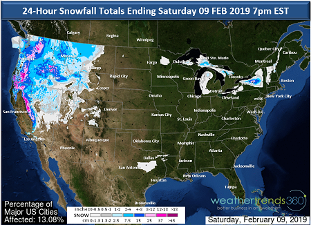
Punxsutawney Phil didn't see his shadow last Saturday, indicating an early spring. As is often the case, Phil is wrong. After a brief flirt with spring-like weather over the past few days across parts of the South and East, we will be thrust back into a much more winter-like pattern. The West has turned much colder and wetter over the past week with feet of mountain snow and heavy valley rain. This pattern of cold and wet weather looks set to continue, in fact, another winter storm is forecast to start impacting areas from the Pacific Northwest and down into the Sierra Nevada today.
Pacific Northwest Storm:Consumers are already stocking up on storm staples in the Pacific Northwest, including in lower elevations cities like Seattle, Tacoma, and Portland. Snow will accumulate several inches in these cities with the heaviest snowfall occurring later this afternoon and into the overnight and gradually wrapping up for the Pacific Northwest cities on Saturday.
Cities Impacted:
As the storm spreads farther south it will bring more heavy snow to the Sierra Nevada with feet of snow falling on top of the several feet of snow that fell earlier this week in the mountains.
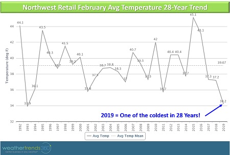
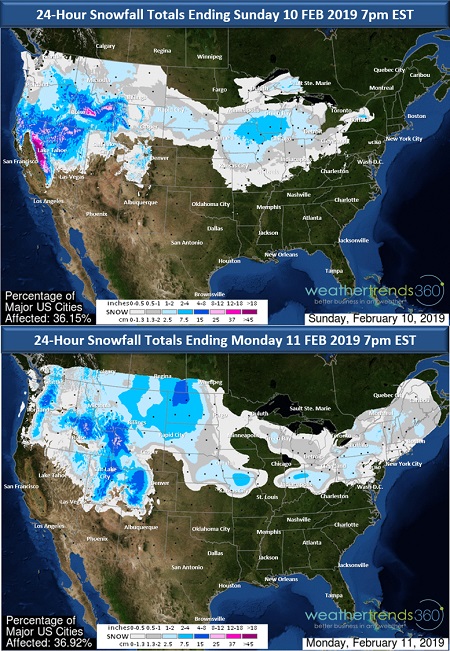
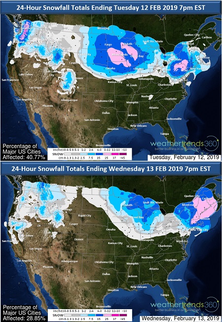
But winter doesn't end there as another storm is forecast to develop late Sunday night into Monday bringing the possibility of more snow for the lower elevations, possibly including Seattle and Portland. And there could be yet another fall of snow in the region by the middle of next week. This pattern will be disruptive for cities that typically receive only a few inches of snow a year. February will likely end up as the 1st or 2nd snowiest retail February in 28+ years for Seattle and Portland. Additionally, this may very well end up being one of the coldest retail Februarys in 28+ years for the cities as well and for the Northwest region as a whole.
Eastern U.S. Storm:Shifting our focus farther east, a recent warm spell comes to an end today as a strong cold front punches through to the East Coast bringing the return of much colder and more winter-like weather for the weekend, especially in the North. The weekend will feature widespread dry conditions to start, but by Sunday some of the energy from the West Coast storms will bring back the threat of wintry weather.
The best chance for snow and ice will be north of the track of the storm from anywhere across the Upper Midwest to the Great Lakes and then along the Ohio River and into the Appalachians and Northeast. Snow and ice will likely bring store traffic disruptions possibly beginning Sunday and again by mid next week in the Midwest and Great Lakes with disruptions possible in the Northeast by the middle of next week.
The track of the storm will decide who sees snow and is likely to change over the next few days so please keep that in mind when viewing the snow forecast maps below.
Cities that may be impacted include:
- Fargo, NC
- Sioux Falls, SD
- Minneapolis, MN
- Des Moines, IA
- Omaha, NE
- Milwaukee, WI
- Chicago, IL
- Indianapolis, IN
- Detroit, MI
- Cleveland, OH
- Washington, DC
- Baltimore, MD
- Philadelphia, PA
- New York City, NY
- Hartford, Ct
- Providence, RI
- Boston, MA
- Buffalo, NY
- Albany, NY
- Burlington, VT
- Manchester, NH
- Portland, ME
This will be the start of another prolonged period of wintry weather. Despite the recent fling with spring, there are still many weeks left to go in winter.