wt360 Weather Brief 18 Jul '26 Northeast U.S. Cool spot - Coolest in 12 Years Back Half July
Captain's Log
18 July '26 Happy Saturday! :)
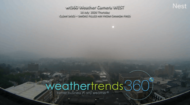
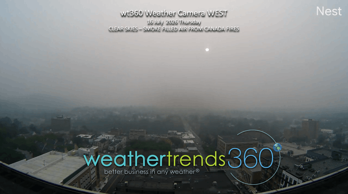
There are two huge areas of timber wildfires in far NW Canada and Southern Ontario with a Northwest wind flow bringing this right into the Great Lakes and Northeast U.S. Fortunately, some rain will wash out the smoke in the Northeast today, it's already starting here in PA after some of the worst air pollution in decades this past Thursday (16 July) as seen from wt360 weather camera WEST. This was a clear sky day but covered in very thick smoke with a dark day and sunny barely visible (see photo below). CLICK ON IMAGES FOR A LARGER VIEW.
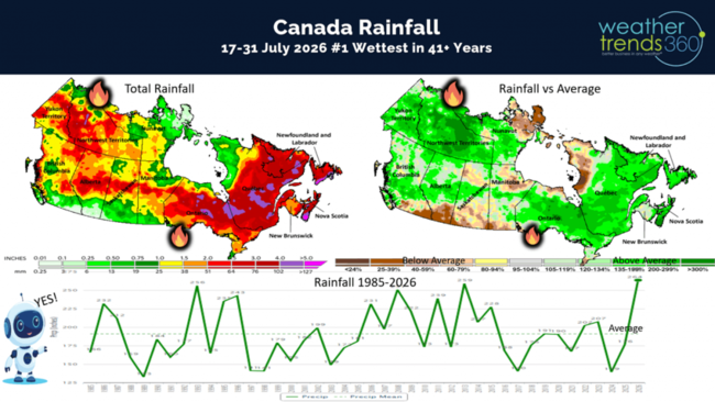
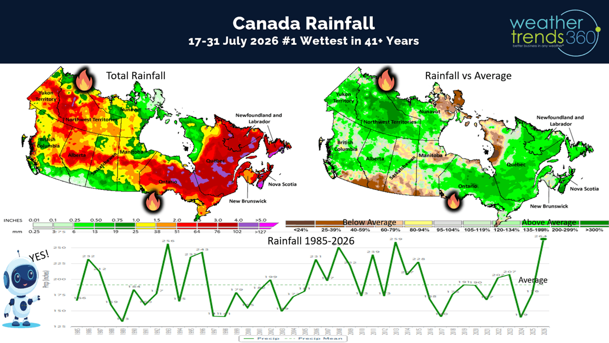
So, let's ask wt360's Sunny AI companion about all these fires and if there is any hope for rain in Canada? The short answer is YES as the latter half of July looks to be the #1 wettest in over 41 years for Canada as a whole. There is SOME heavier rain for the big fire areas but probably not enough to entirely put them out. Hopefully gives fire agencies a leg up on putting these out. Usually, big timber fires like this need snow to fully extinguish them.
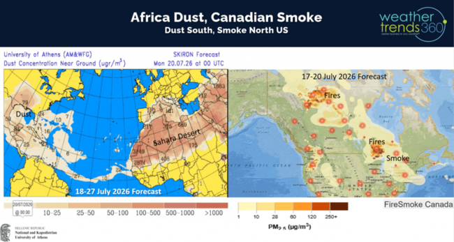
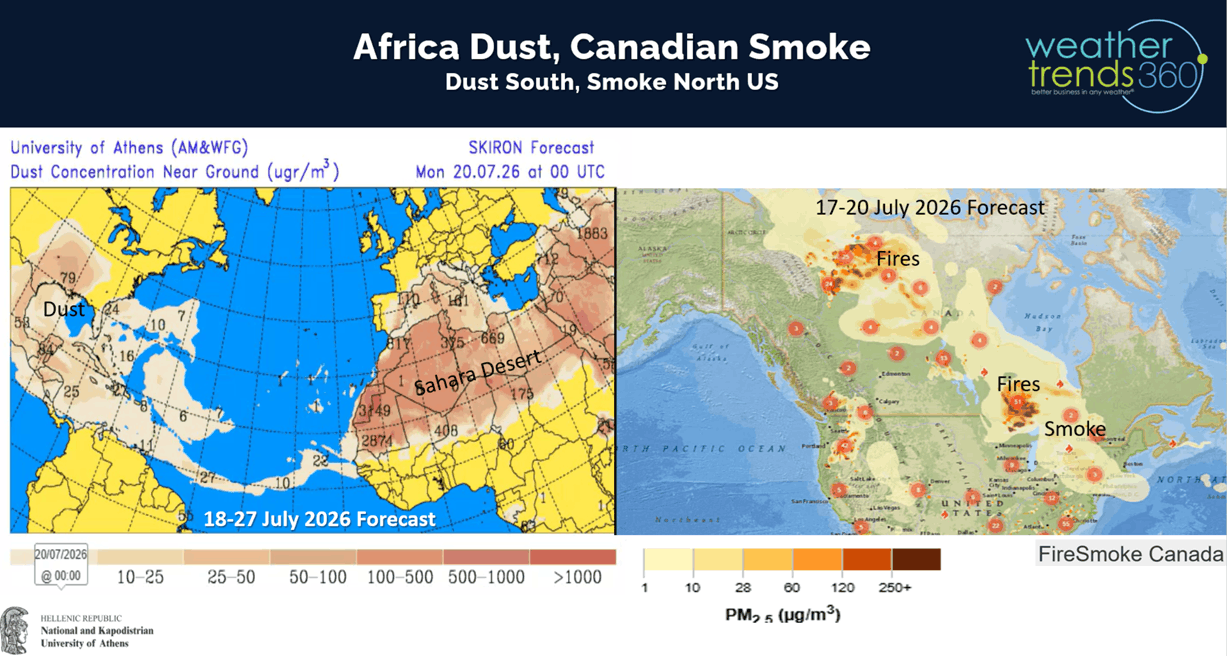
The 3-day smoke forecast shows some improvement while the Africa dust over the next 10 days invades the South Central U.S. Usually, the dust is suspended higher in the atmosphere and less problematic than the smoke when it comes to air quality.
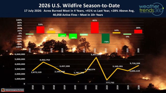
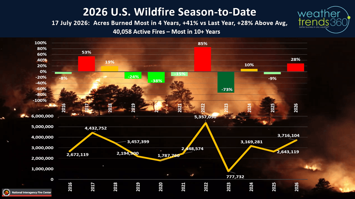
U.S. wildfires are the most in 10+ years in terms of the number of fires (40,058) and the most in 4 years in terms of acres burned (3.7M vs 2.6M last year).
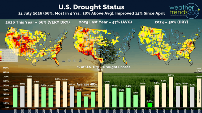
Drought in the U.S. is making slow progress with 66% of the U.S. in dry to drought phases. This is down from the peak of 80% of the country in dry phases back on 1 April. Still the most in 4 years. Drought in West Texas is obviously over with the excessive flooding the past week.
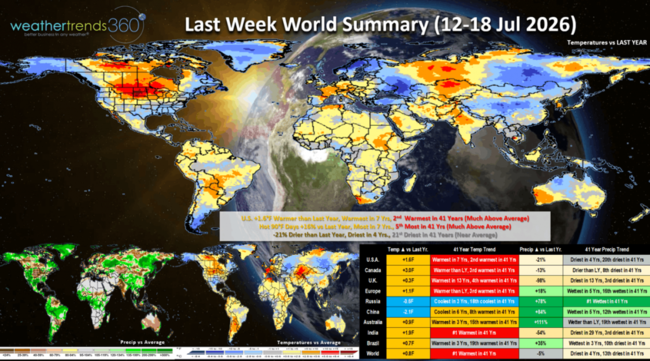
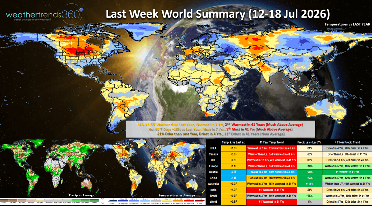
The Last Week World Summary (12-18 July) shows the U.S. trending +1.6F warmer than last year, warmest in 7 years and 2nd warmest in 41 years. Hot 90F days were also up +16% vs LY, most in 7 years and 5th most in 41 years, while national rainfall was down -21% vs LY, driest in 4 years and 21st driest of the past 41 years. Warmer/Drier trends this time of year favor consumable categories like cold beverages, pool chemicals, auto batteries, sun care and with all the smoke - asthma medications. Canada, U.K. and India were hot and dry while some rain made Europe wetter and very wet in Russia.
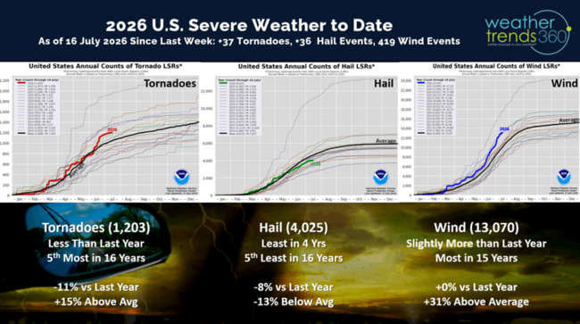
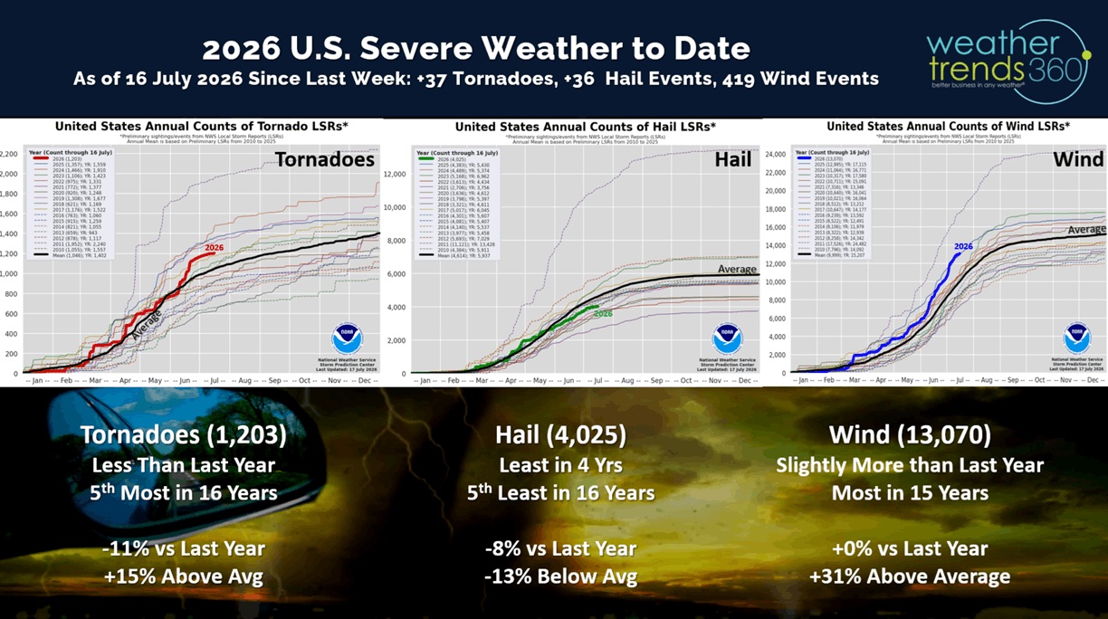
With the warmer/drier trend in the U.S., severe weather had a bit of a lull only adding 37 tornadoes, 36 hail and 419 wind events since last week. All categories trending below last year's levels, but wind and tornadoes still well above average season to date.
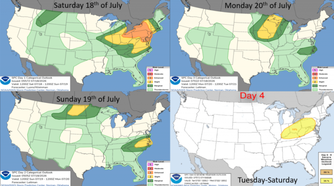
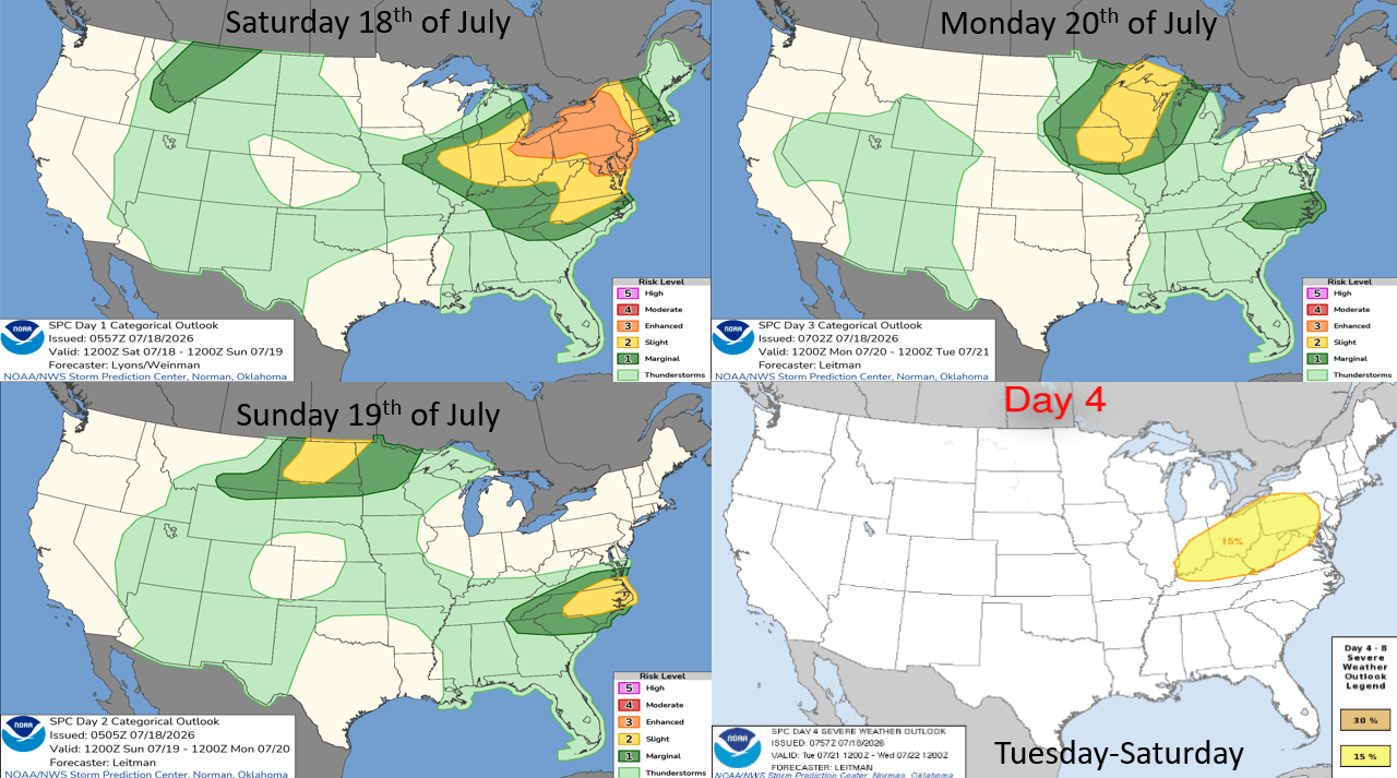
The week ahead severe weather outlook shows high risk here in the Northeast today, shifting back to the Upper Midwest where rain hopefully helps the big fires. More severe risk back in the East by Tuesday.
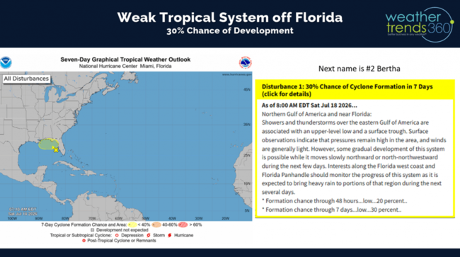
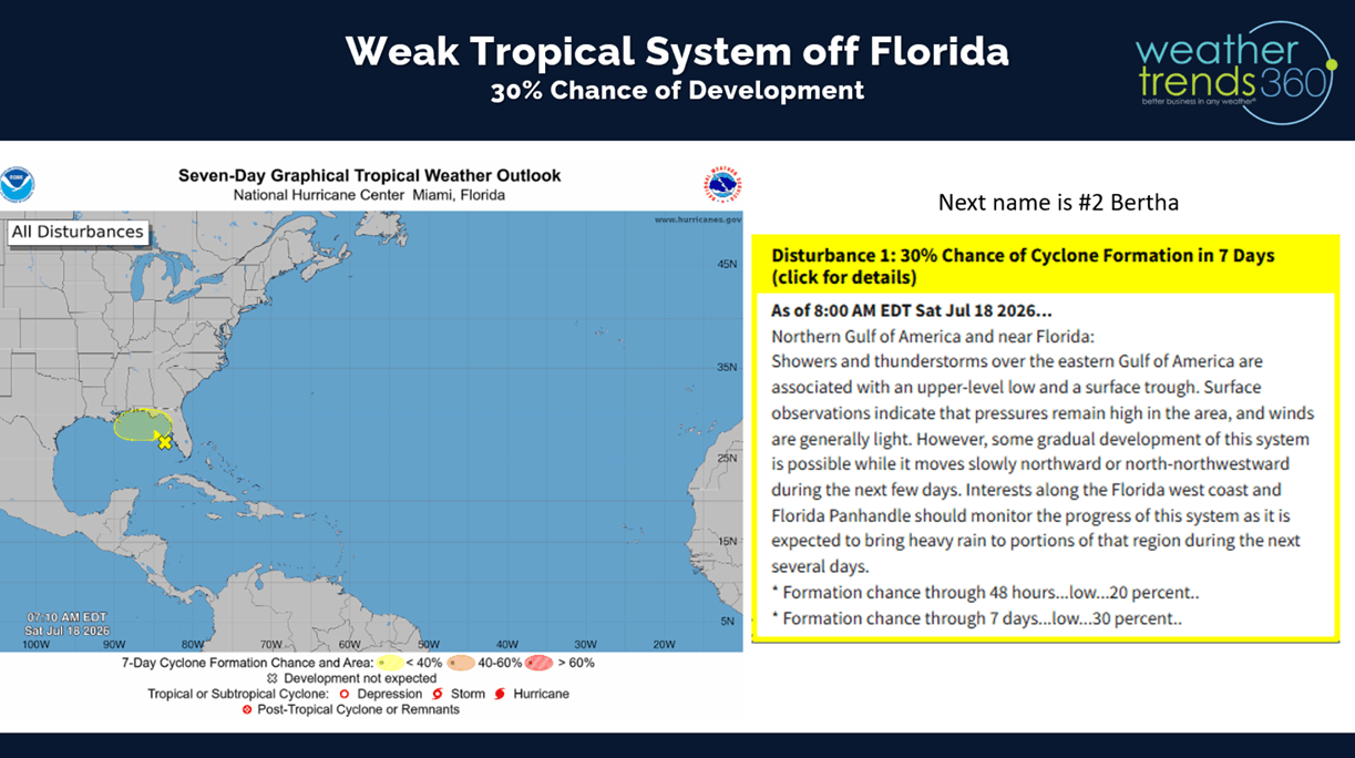
There is a tropical like disturbance off the West Coast of Florida that has a slight chance of becoming Tropical Storm #2. It will remain weak, bringing some rain to the Southeast Gulf states.
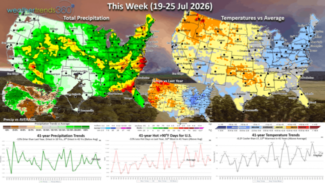
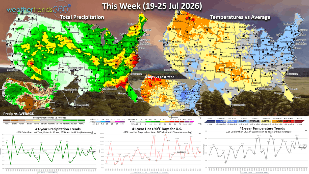
The U.S. Weekly Outlook (19-25 July) shows a much cooler pattern for the Midwest and especially the Northeast (coolest in 12 years) with heat building in the Pacific Northwest and South Central States. The U.S. overall trends -0.2F cooler than last year but 13th warmest of the past 41 years. Hot 90F index is down -11% vs LY and 16th most in 41 years, while rainfall is down -13% vs LY, driest in 10 years and 6th driest in 41 years. This favors higher Summer consumable category sales in the NW vs the NE.
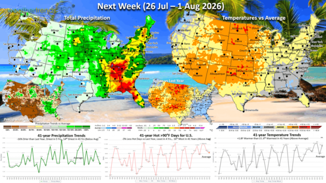
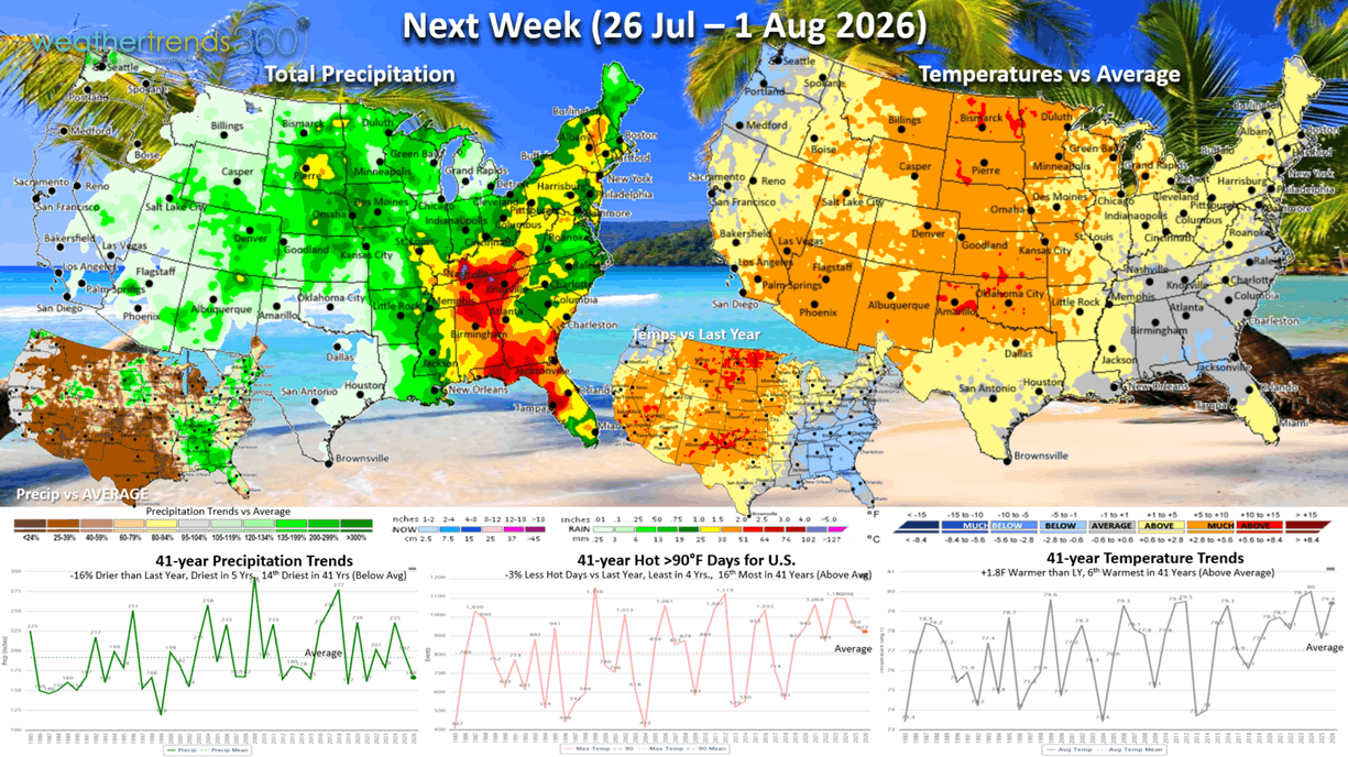
Next Week (26 Jul - 1 Aug) the U.S. overall trends +1.8F warmer than last year and 6th warmest of the past 41 years. But the hot 90F index is down -3% vs LY, least in 4 years and 16th most in the past 41 years. The Plains and Southwest will be the hottest regions. National rainfall again down -16% vs LY, driest in 5 years and 14th driest of the past 41 years. Some tropical moisture in the Southeast. The highest demand for Summer consumable categories will be in the Central U.S. The Western Corn Belt looks to get some rain after suffering through the recent heat dome. Back2School starts in early to middle August across the Southeast and West, so many are likely getting in their last Summer vacations.
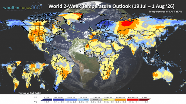
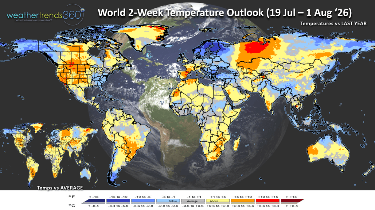
The World 2-week Temperature outlook (19 Jul - 1 Aug) shows a generally cooler pattern for the Eastern U.S., hotter Central and West. Western Europe hotter, Eastern Europe cooler while Northern Europe is very cool.
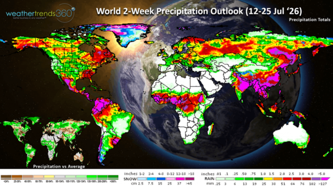
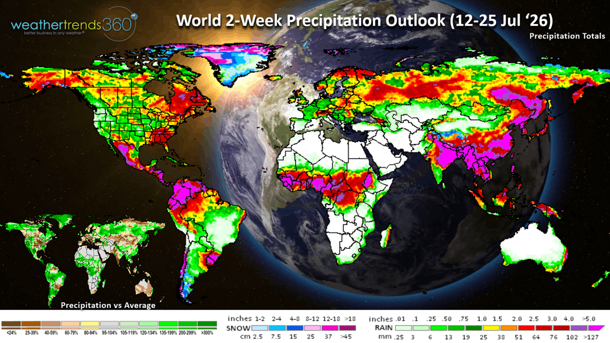
The World 2-week Precipitation outlook (19 Jul - 1 Aug) shows above average rainfall in the Western U.S. which still isn't much, but it can bring thunderstorms that can increase the wildfire threat. The Southeast U.S. is the wet spot as is Argentina and Coastal China.
You can get this blog in your email inbox every weekend (FREE) via subscription.
Have a great week ahead, and don't forget to follow us on social media for updates: Facebook, Twitter(X), YouTube, Pinterest and Linkedin.
- Captain Kirk out (USAF Gulf War Veteran 1989-1999)
There are two huge areas of timber wildfires in far NW Canada and Southern Ontario with a Northwest wind flow bringing this right into the Great Lakes and Northeast U.S. Fortunately, some rain will wash out the smoke in the Northeast today, it's already starting here in PA after some of the worst air pollution in decades this past Thursday (16 July) as seen from wt360 weather camera WEST. This was a clear sky day but covered in very thick smoke with a dark day and sunny barely visible (see photo below). CLICK ON IMAGES FOR A LARGER VIEW.
So, let's ask wt360's Sunny AI companion about all these fires and if there is any hope for rain in Canada? The short answer is YES as the latter half of July looks to be the #1 wettest in over 41 years for Canada as a whole. There is SOME heavier rain for the big fire areas but probably not enough to entirely put them out. Hopefully gives fire agencies a leg up on putting these out. Usually, big timber fires like this need snow to fully extinguish them.
The 3-day smoke forecast shows some improvement while the Africa dust over the next 10 days invades the South Central U.S. Usually, the dust is suspended higher in the atmosphere and less problematic than the smoke when it comes to air quality.
U.S. wildfires are the most in 10+ years in terms of the number of fires (40,058) and the most in 4 years in terms of acres burned (3.7M vs 2.6M last year).
Drought in the U.S. is making slow progress with 66% of the U.S. in dry to drought phases. This is down from the peak of 80% of the country in dry phases back on 1 April. Still the most in 4 years. Drought in West Texas is obviously over with the excessive flooding the past week.

The Last Week World Summary (12-18 July) shows the U.S. trending +1.6F warmer than last year, warmest in 7 years and 2nd warmest in 41 years. Hot 90F days were also up +16% vs LY, most in 7 years and 5th most in 41 years, while national rainfall was down -21% vs LY, driest in 4 years and 21st driest of the past 41 years. Warmer/Drier trends this time of year favor consumable categories like cold beverages, pool chemicals, auto batteries, sun care and with all the smoke - asthma medications. Canada, U.K. and India were hot and dry while some rain made Europe wetter and very wet in Russia.
With the warmer/drier trend in the U.S., severe weather had a bit of a lull only adding 37 tornadoes, 36 hail and 419 wind events since last week. All categories trending below last year's levels, but wind and tornadoes still well above average season to date.
The week ahead severe weather outlook shows high risk here in the Northeast today, shifting back to the Upper Midwest where rain hopefully helps the big fires. More severe risk back in the East by Tuesday.
There is a tropical like disturbance off the West Coast of Florida that has a slight chance of becoming Tropical Storm #2. It will remain weak, bringing some rain to the Southeast Gulf states.
The U.S. Weekly Outlook (19-25 July) shows a much cooler pattern for the Midwest and especially the Northeast (coolest in 12 years) with heat building in the Pacific Northwest and South Central States. The U.S. overall trends -0.2F cooler than last year but 13th warmest of the past 41 years. Hot 90F index is down -11% vs LY and 16th most in 41 years, while rainfall is down -13% vs LY, driest in 10 years and 6th driest in 41 years. This favors higher Summer consumable category sales in the NW vs the NE.
Next Week (26 Jul - 1 Aug) the U.S. overall trends +1.8F warmer than last year and 6th warmest of the past 41 years. But the hot 90F index is down -3% vs LY, least in 4 years and 16th most in the past 41 years. The Plains and Southwest will be the hottest regions. National rainfall again down -16% vs LY, driest in 5 years and 14th driest of the past 41 years. Some tropical moisture in the Southeast. The highest demand for Summer consumable categories will be in the Central U.S. The Western Corn Belt looks to get some rain after suffering through the recent heat dome. Back2School starts in early to middle August across the Southeast and West, so many are likely getting in their last Summer vacations.
The World 2-week Temperature outlook (19 Jul - 1 Aug) shows a generally cooler pattern for the Eastern U.S., hotter Central and West. Western Europe hotter, Eastern Europe cooler while Northern Europe is very cool.
The World 2-week Precipitation outlook (19 Jul - 1 Aug) shows above average rainfall in the Western U.S. which still isn't much, but it can bring thunderstorms that can increase the wildfire threat. The Southeast U.S. is the wet spot as is Argentina and Coastal China.
You can get this blog in your email inbox every weekend (FREE) via subscription.
Have a great week ahead, and don't forget to follow us on social media for updates: Facebook, Twitter(X), YouTube, Pinterest and Linkedin.
- Captain Kirk out (USAF Gulf War Veteran 1989-1999)