wt360 Weather Brief 19 Sep '26 - Northeast Most Fall Like
Captain's Log
19 Sep '26: Happy Saturday! :)
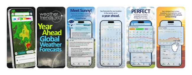
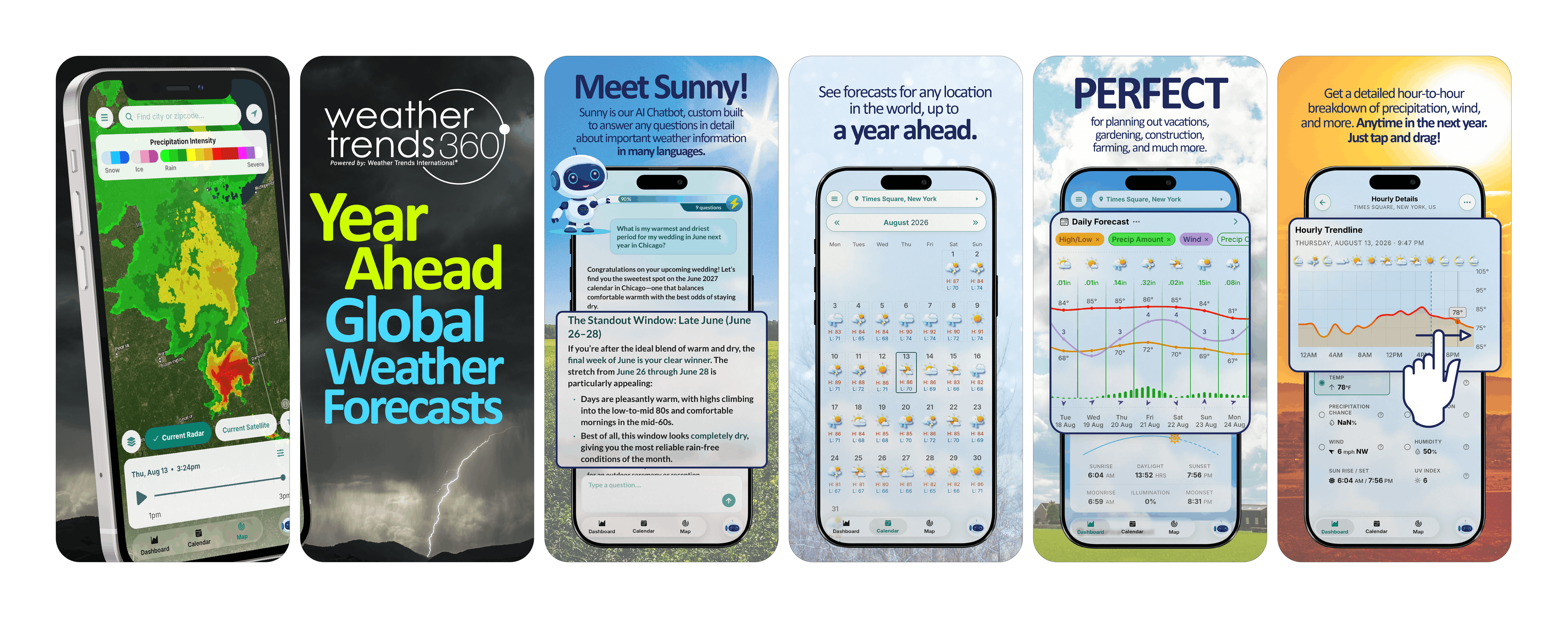
If you haven't downloaded our new App - weathertrends360 - with Sunny AI companion yet, check it out...you'll love it! :) More info on Sunny's landing page. And you'll love the new lightning alert tool we're adding with our coming update with more languages and other enhancements. CLICK ON IMAGES FOR A LARGER VIEW
Apple: https://apps.apple.com/us/app/weathertrends360-year-ahead/id6767758303
Android: https://play.google.com/store/apps/details?id=com.weathertrends.app
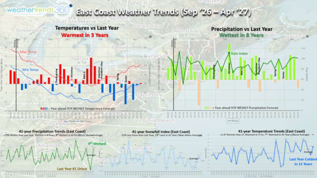
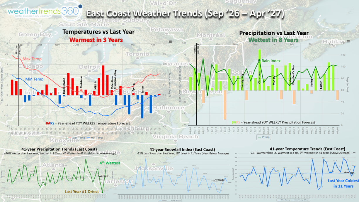
So let's ask Sunny something LONG RANGE on our East Coast Winter Outlook. There's obviously a ton of news on this near historic El Niño about to peak this Fall, but how it will impact the East Coast might be different than you expect. The one near certainty is WET WET WET with a wholesale change from last year's driest Winter in over 41 years. wt360 is projecting the wettest in 8 years, 4th wettest in 41 years, but also WARMER, warmest in 3 years and 7th warmest in 41 years. Very different than last year's coldest Winter in 11 years. Snow is the big IF with all this moisture, but our outlook suggests 12% less snow than last year and near to slightly below average. While most Nor'easters will be WET up the East Coast, one could very well be a big SNOWSTORM. Last year brought the Northeast over 20 snowy events, this year substantially fewer days with snow.
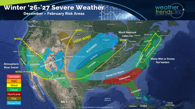
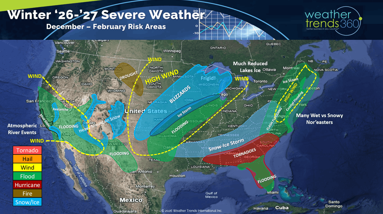
The U.S. overall Severe Weather Winter Outlook shows the classic wet storm track from the Southwest up the East Coast. The Southwest mountains should have a huge snow year and heavier snow in the East will require higher elevations. A Deep South snow and Ice event more likely as is a severe Ice storm in New England. A secondary spike in Severe Weather - Tornadoes - likely in the Southeast. While El Niño's can make the Northern tier warm and dry, we do think a bigger blizzard or two is likely, especially late Winter into early Spring. Bottom line theme - VERY WET WITH WIDESPREAD FLOODING.
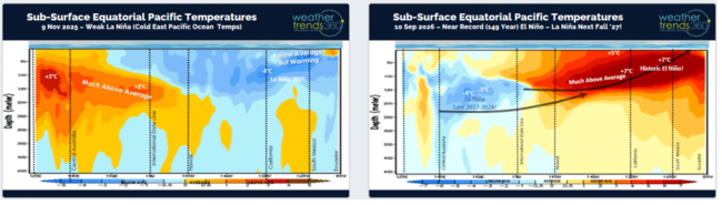
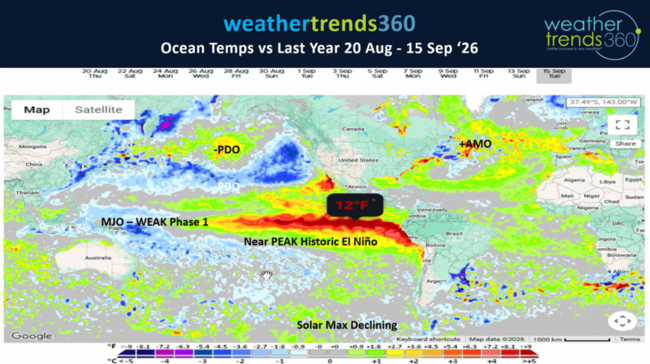
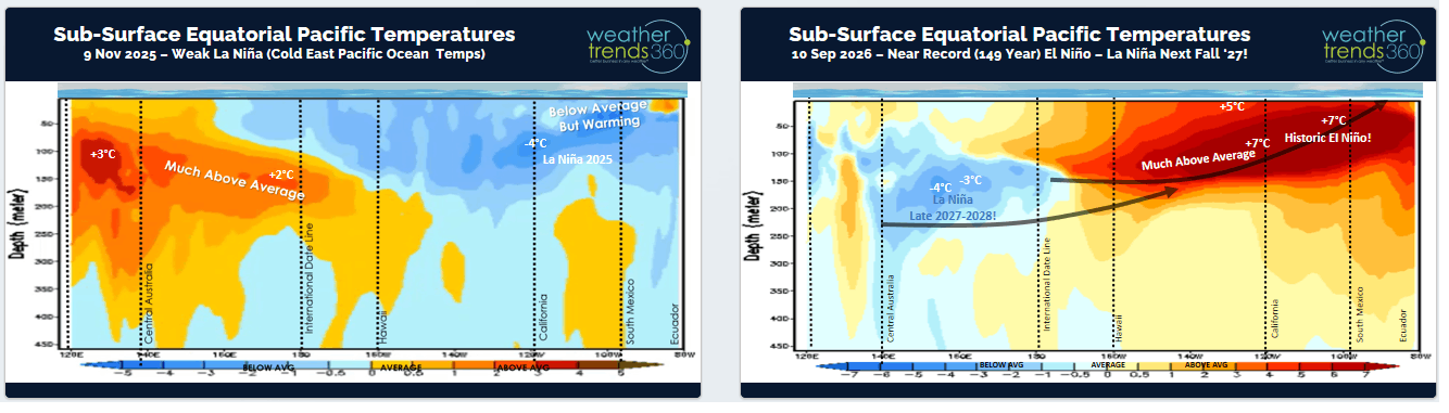
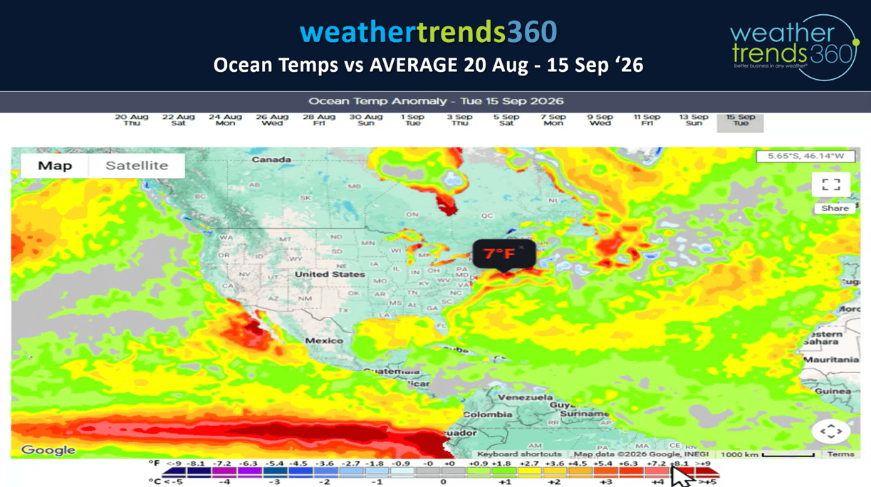
What about El Niño? It's getting very near its strongest levels, going back 149 years (1877). This time last year La Nina with cold Eastern Pacific Equatorial water temperatures, now near record warm waters. But notice the BELOW NORMAL waters under the surface out in the Western Pacific, that's a very clear sign we'll be talking moderate La Niña this time next year. So, get ready as this will be one very volatile weather pattern over the next year.
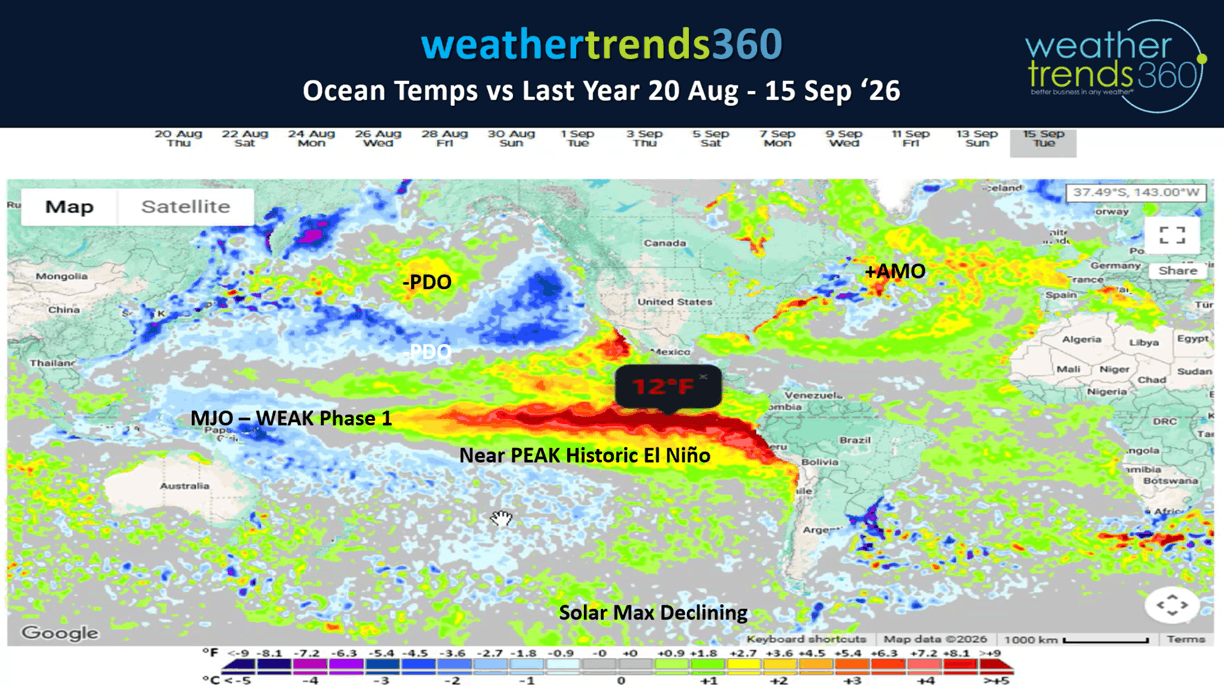
Some areas in the Eastern Pacific oceans are a whopping +10°F above average which pumps a ton of water vapor into the global atmospheric circulation. Putting this into context, the strongest El Niño 3.4 basin region index was +3.1ºC (+5.6ºF) way back in 1877 (149 years ago).
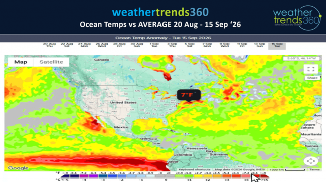
Notice the +7ºF waters off the East Coast which is one catalyst for a warmer Winter ahead. It will also push milder air in ahead of big Nor'easters resulting in more rain than snow. It will take most of the Winter to cool this down, so a bigger snowstorm more likely late Winter into early Spring.
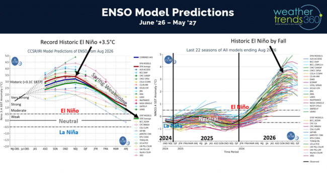
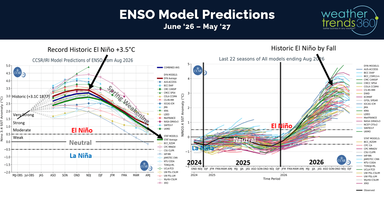
With all that evidence, not surprising the models show an historic El Niño getting close to peaking in the Nov-Dec timeframe and then a rapid weakening into Spring.
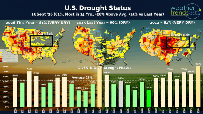
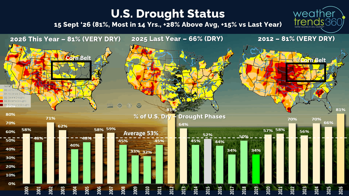
Drought still shows 81% of the U.S. in dry to drought phases, but this is an assessment of the past year. Many areas in the South and East have already started to get very wet, so the La Nina pattern last year that created this drought is coming to an end.
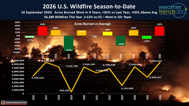
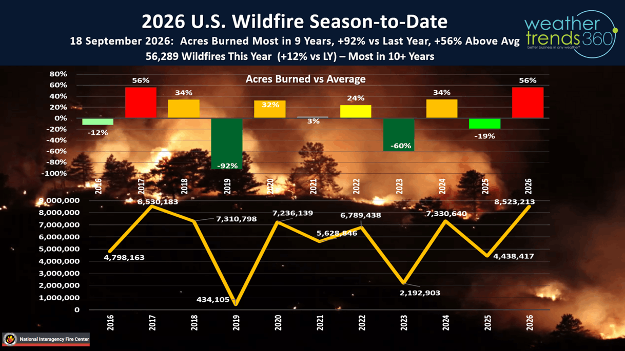
Wildfires have consumed 8.52M acres this year, most in 9 years, +92% more than last year and +56% above average. The number of fires has reached 56,289, the highest in over 10 years. Still risk for a few BIG fires in the West into early November.
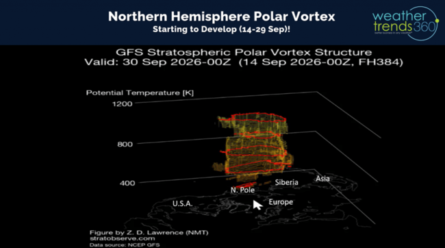
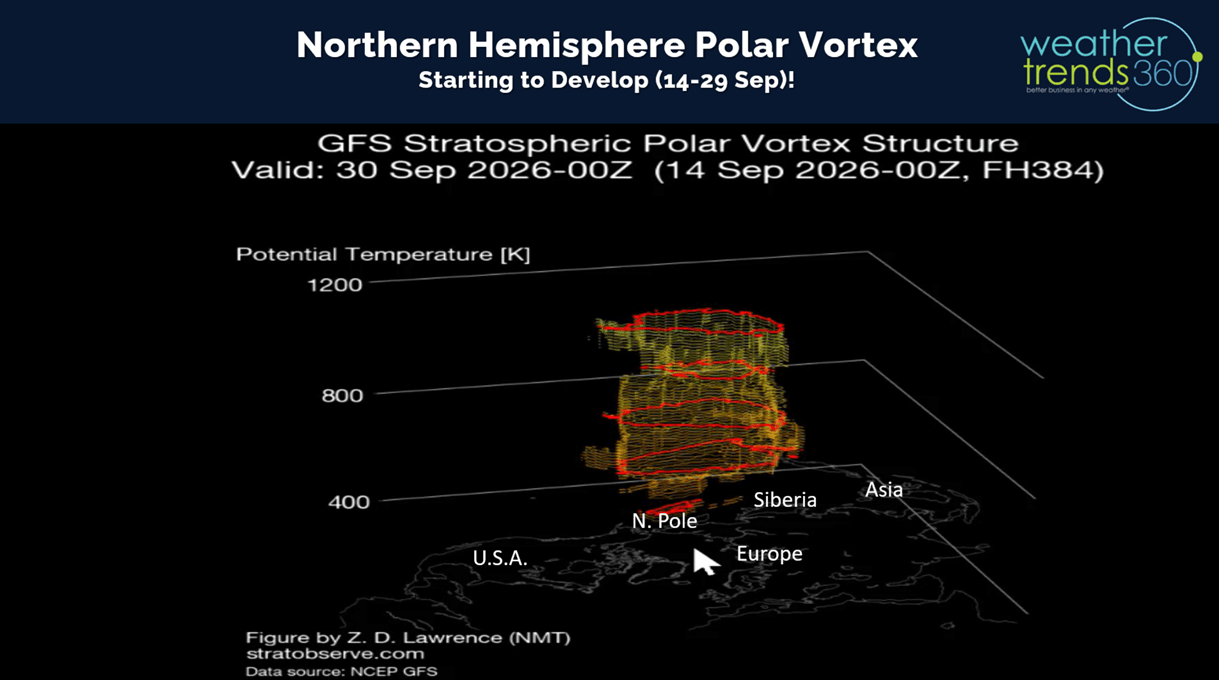
As we approach Fall, the Polar Vortex continues to develop at the North Pole but it's still in the upper atmosphere and not yet reaching the surface. It will be a factor this Winter, but likely to remain stronger keeping major prolonged Arctic outbreaks much fewer than last year in the Eastern U.S.
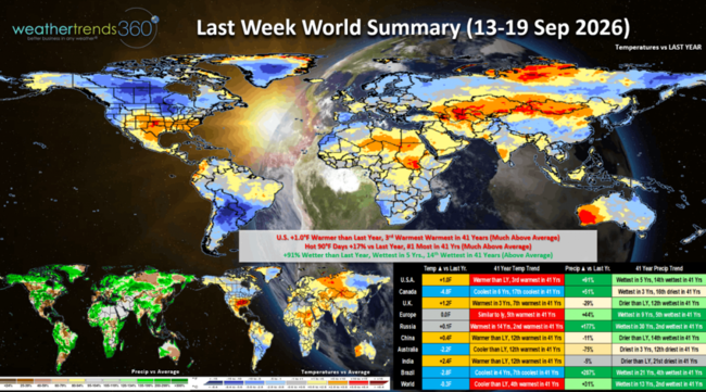
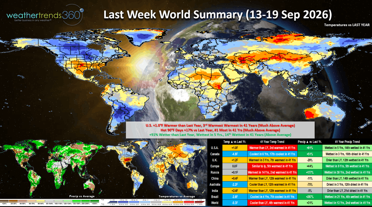
Last Week 13-19 Sept across the World shows the U.S. trending +1F warmer than last year and 3rd warmest in 41 years. The Norther tier was the cool spot with the best weather for Fall seasonal merchandise sales. The South Central baked. Hot 90F days were +17% more than last year and #1 most in 41+ years. Rainfall was way up +91% vs last year, wettest in 5 years and 14th wettest in 41 years. These were generally unfavorable trends for Fall merchandise but a benefit to Summer consumable items like cold beverages. Canada was again much cooler with the greatest demand for Fall items. The World overall continues to show the atmosphere responding to El Nino, trending wettest in 13 years and 2nd wettest in 41 years.
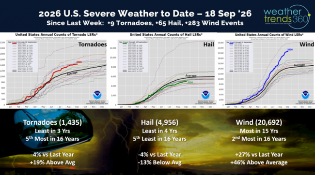
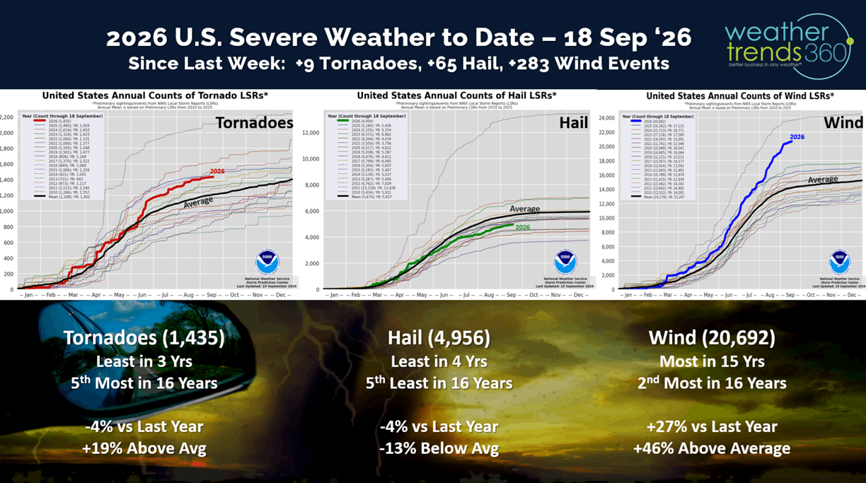
Severe weather was a bit quieter this past week only adding 9 tornadoes, 65 hail events and 283 wind events since last week.
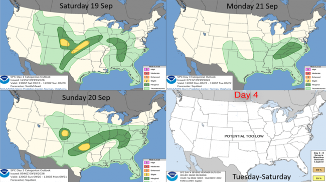
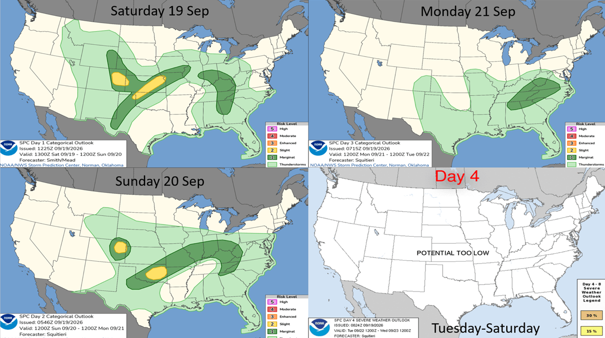
The week ahead severe weather threats show some severe weather in the Central U.S., they'll take the rain but not the severe weather.
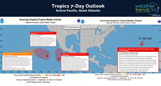
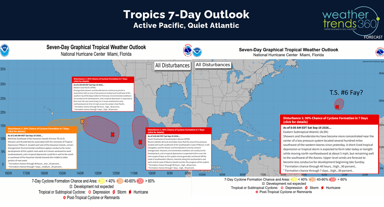
The tropics remain active in the Pacific with 3 potential systems and maybe 1 short lived event way out in the Atlantic. The Atlantic system not expected to impact land, and it would be named Fay, our 6th T.S. Overall the Atlantic is off to one of the slowest starts in recorded history and yet to get a hurricane.
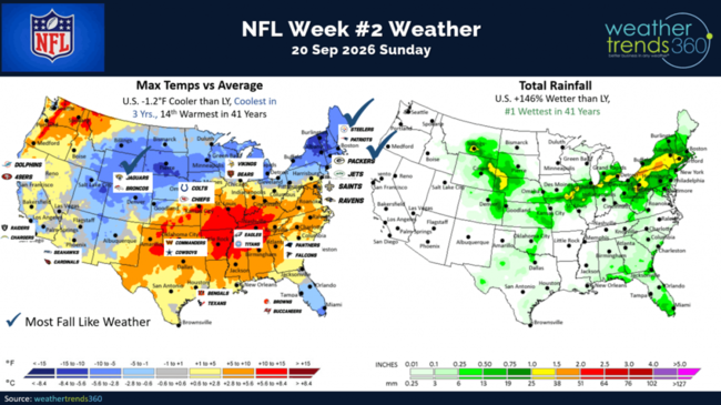
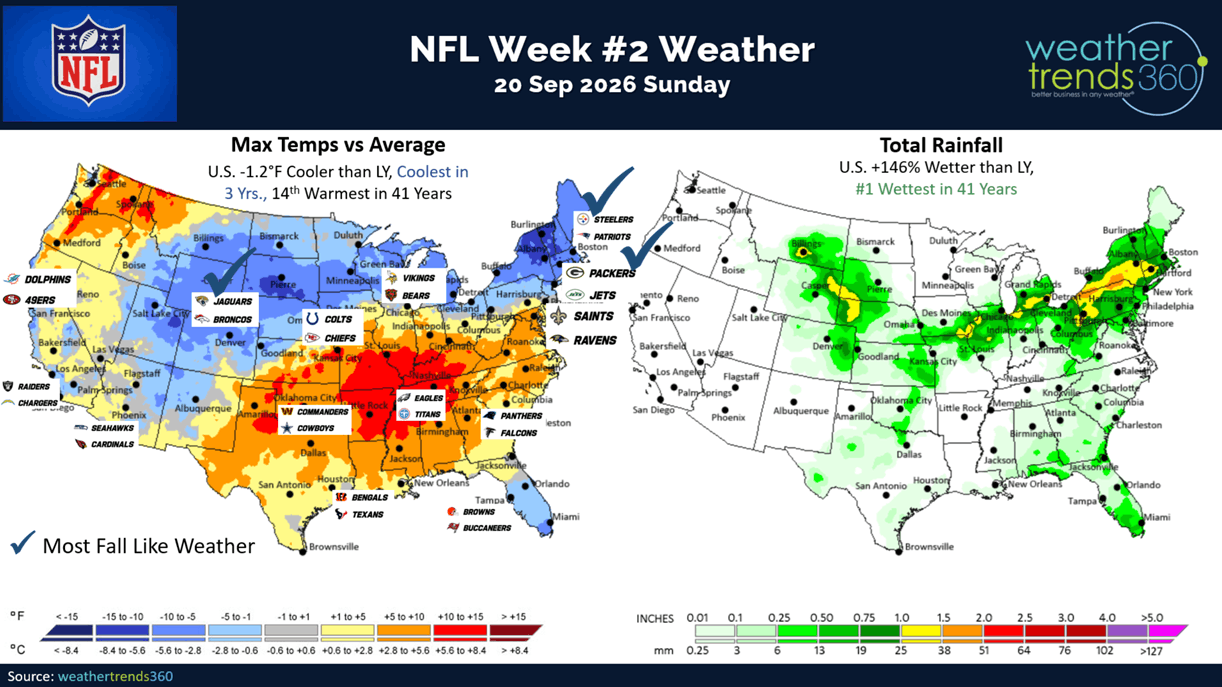
Week 2 for NFL football shows the Northeast and Rockies will have the most Fall like football weather. Continued hot in the Central U.S. Overall Sunday is the coolest in 3 years and #1 wettest in 41 years for the U.S. overall.
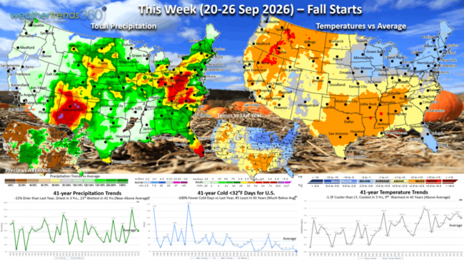
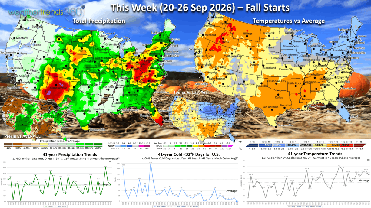
This week (20-26 Sep) is the start of Fall and it's a bit cooler start than last year trending -1.3F cooler than LY, coolest in 3 years but still 9th warmest of the past 41 years. The Midwest into the Northeast the cool spot (below average temps) with a pent-up demand surge in Fall apparel sales. Our 32F cold day index shows the #1 least in 41 years, while rainfall is down -11% vs LY, driest in 3 years but 21st wettest in 41 years (near avg).
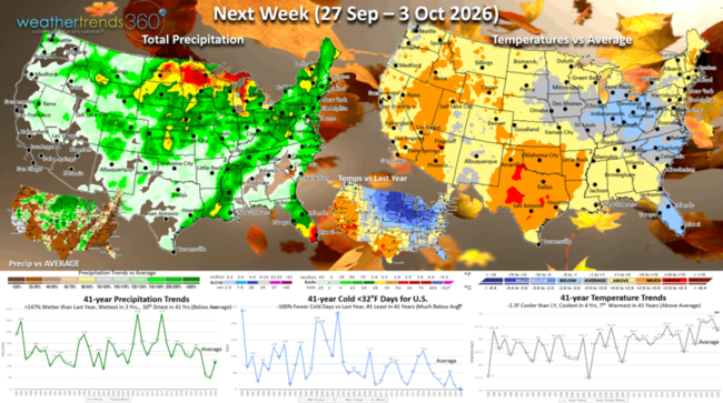
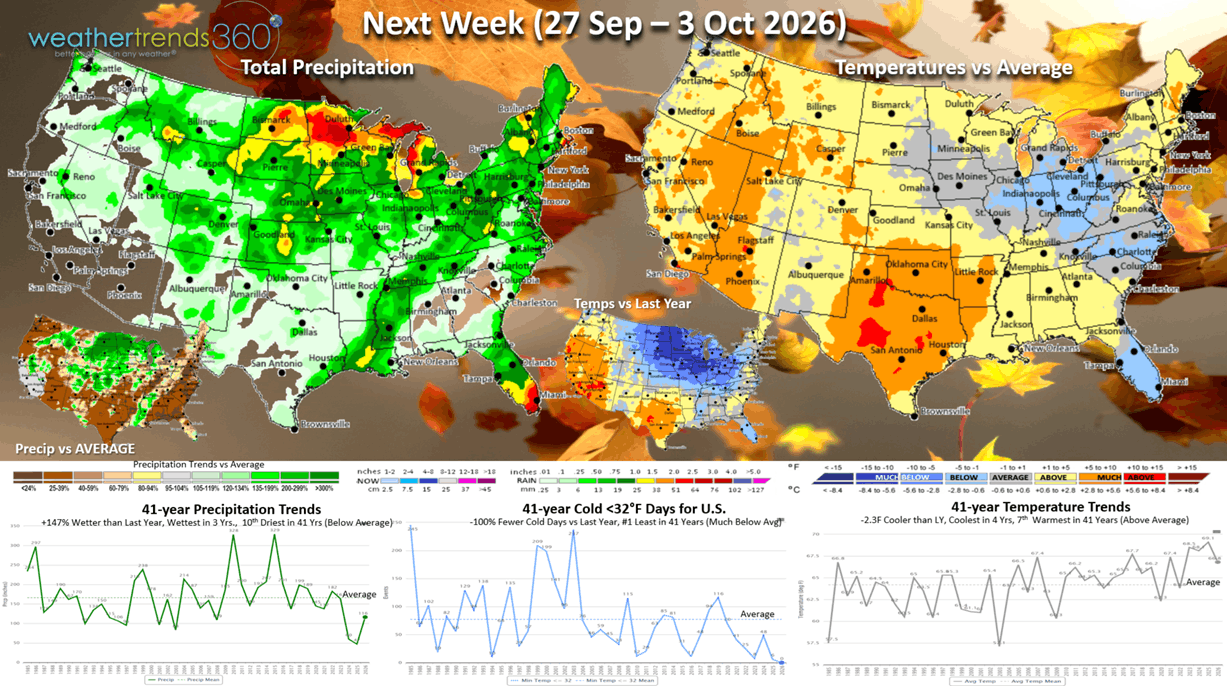
Next week (27 Sep - 3 Oct) shows the U.S. overall trending -2.3F cooler than LY, coolest in 4 years but 7th warmest in 41 year. The Midwest into the Middle Atlantic the favored area for Fall apparel. Rainfall up +147% vs LY, most in 3 years but still 10th driest in 41 years nationally. The ideal weather this time of year is cold and wet weather to drive Fall sales.
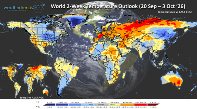
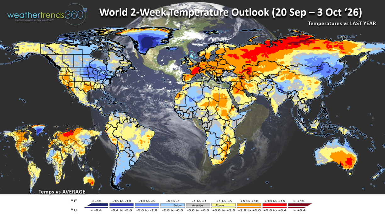
The World 2-week Temperature Outlook (20 Sep - 3 Oct) shows Southeast Canada, The Eastern U.S. and NE China as the favorable spots for Fall sales.
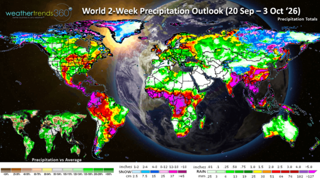
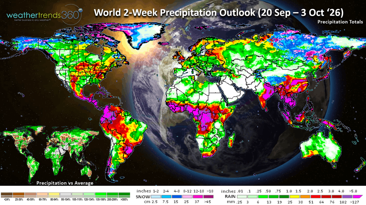
The World 2-week Precipitation Outlook (20 Sep - 3 Oct) shows wet weather in the U.S. Plains - much needed for this drought area. Very wet across Brazil and Africa.
You can get this blog in your email inbox every weekend (FREE) via subscription.
Have a great week ahead, and don't forget to follow us on social media for updates: Facebook, Twitter(X), YouTube, Pinterest and Linkedin.
- Captain Kirk out (USAF Gulf War Veteran 1989-1999)
If you haven't downloaded our new App - weathertrends360 - with Sunny AI companion yet, check it out...you'll love it! :) More info on Sunny's landing page. And you'll love the new lightning alert tool we're adding with our coming update with more languages and other enhancements. CLICK ON IMAGES FOR A LARGER VIEW
Apple: https://apps.apple.com/us/app/weathertrends360-year-ahead/id6767758303
Android: https://play.google.com/store/apps/details?id=com.weathertrends.app
So let's ask Sunny something LONG RANGE on our East Coast Winter Outlook. There's obviously a ton of news on this near historic El Niño about to peak this Fall, but how it will impact the East Coast might be different than you expect. The one near certainty is WET WET WET with a wholesale change from last year's driest Winter in over 41 years. wt360 is projecting the wettest in 8 years, 4th wettest in 41 years, but also WARMER, warmest in 3 years and 7th warmest in 41 years. Very different than last year's coldest Winter in 11 years. Snow is the big IF with all this moisture, but our outlook suggests 12% less snow than last year and near to slightly below average. While most Nor'easters will be WET up the East Coast, one could very well be a big SNOWSTORM. Last year brought the Northeast over 20 snowy events, this year substantially fewer days with snow.
The U.S. overall Severe Weather Winter Outlook shows the classic wet storm track from the Southwest up the East Coast. The Southwest mountains should have a huge snow year and heavier snow in the East will require higher elevations. A Deep South snow and Ice event more likely as is a severe Ice storm in New England. A secondary spike in Severe Weather - Tornadoes - likely in the Southeast. While El Niño's can make the Northern tier warm and dry, we do think a bigger blizzard or two is likely, especially late Winter into early Spring. Bottom line theme - VERY WET WITH WIDESPREAD FLOODING.
What about El Niño? It's getting very near its strongest levels, going back 149 years (1877). This time last year La Nina with cold Eastern Pacific Equatorial water temperatures, now near record warm waters. But notice the BELOW NORMAL waters under the surface out in the Western Pacific, that's a very clear sign we'll be talking moderate La Niña this time next year. So, get ready as this will be one very volatile weather pattern over the next year.
Some areas in the Eastern Pacific oceans are a whopping +10°F above average which pumps a ton of water vapor into the global atmospheric circulation. Putting this into context, the strongest El Niño 3.4 basin region index was +3.1ºC (+5.6ºF) way back in 1877 (149 years ago).
Notice the +7ºF waters off the East Coast which is one catalyst for a warmer Winter ahead. It will also push milder air in ahead of big Nor'easters resulting in more rain than snow. It will take most of the Winter to cool this down, so a bigger snowstorm more likely late Winter into early Spring.
With all that evidence, not surprising the models show an historic El Niño getting close to peaking in the Nov-Dec timeframe and then a rapid weakening into Spring.
Drought still shows 81% of the U.S. in dry to drought phases, but this is an assessment of the past year. Many areas in the South and East have already started to get very wet, so the La Nina pattern last year that created this drought is coming to an end.
Wildfires have consumed 8.52M acres this year, most in 9 years, +92% more than last year and +56% above average. The number of fires has reached 56,289, the highest in over 10 years. Still risk for a few BIG fires in the West into early November.
As we approach Fall, the Polar Vortex continues to develop at the North Pole but it's still in the upper atmosphere and not yet reaching the surface. It will be a factor this Winter, but likely to remain stronger keeping major prolonged Arctic outbreaks much fewer than last year in the Eastern U.S.
Last Week 13-19 Sept across the World shows the U.S. trending +1F warmer than last year and 3rd warmest in 41 years. The Norther tier was the cool spot with the best weather for Fall seasonal merchandise sales. The South Central baked. Hot 90F days were +17% more than last year and #1 most in 41+ years. Rainfall was way up +91% vs last year, wettest in 5 years and 14th wettest in 41 years. These were generally unfavorable trends for Fall merchandise but a benefit to Summer consumable items like cold beverages. Canada was again much cooler with the greatest demand for Fall items. The World overall continues to show the atmosphere responding to El Nino, trending wettest in 13 years and 2nd wettest in 41 years.
Severe weather was a bit quieter this past week only adding 9 tornadoes, 65 hail events and 283 wind events since last week.
The week ahead severe weather threats show some severe weather in the Central U.S., they'll take the rain but not the severe weather.
The tropics remain active in the Pacific with 3 potential systems and maybe 1 short lived event way out in the Atlantic. The Atlantic system not expected to impact land, and it would be named Fay, our 6th T.S. Overall the Atlantic is off to one of the slowest starts in recorded history and yet to get a hurricane.
Week 2 for NFL football shows the Northeast and Rockies will have the most Fall like football weather. Continued hot in the Central U.S. Overall Sunday is the coolest in 3 years and #1 wettest in 41 years for the U.S. overall.
This week (20-26 Sep) is the start of Fall and it's a bit cooler start than last year trending -1.3F cooler than LY, coolest in 3 years but still 9th warmest of the past 41 years. The Midwest into the Northeast the cool spot (below average temps) with a pent-up demand surge in Fall apparel sales. Our 32F cold day index shows the #1 least in 41 years, while rainfall is down -11% vs LY, driest in 3 years but 21st wettest in 41 years (near avg).
Next week (27 Sep - 3 Oct) shows the U.S. overall trending -2.3F cooler than LY, coolest in 4 years but 7th warmest in 41 year. The Midwest into the Middle Atlantic the favored area for Fall apparel. Rainfall up +147% vs LY, most in 3 years but still 10th driest in 41 years nationally. The ideal weather this time of year is cold and wet weather to drive Fall sales.
The World 2-week Temperature Outlook (20 Sep - 3 Oct) shows Southeast Canada, The Eastern U.S. and NE China as the favorable spots for Fall sales.
The World 2-week Precipitation Outlook (20 Sep - 3 Oct) shows wet weather in the U.S. Plains - much needed for this drought area. Very wet across Brazil and Africa.
You can get this blog in your email inbox every weekend (FREE) via subscription.
Have a great week ahead, and don't forget to follow us on social media for updates: Facebook, Twitter(X), YouTube, Pinterest and Linkedin.
- Captain Kirk out (USAF Gulf War Veteran 1989-1999)