wt360 Weather Brief 22 Aug '26 Increasingly WET El Nino Pattern - Wettest in 5 Years for U.S.
Captain's Log
22 Aug '26: Happy Saturday! :)
The countdown has started to the release of our super cool does everything AI weather and business app...in the stores 1 September (app name is weathertrends360)!
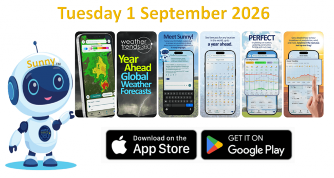
Sunny™ your AI weather companion will speak many languages with year-ahead intelligence on 360 equity stock indices, 220 seasonal category sales trends, 3 diseases (Asthma, Allergy, Flu) and weather intel for 32 million spots on Earth (that's every mile).
Watch the video
CLICK ON IMAGES FOR A LARGER VIEW

Let's ask Sunny for a summary of "meteorological" Summer which is 1 June - 31 August.
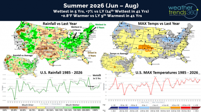
It's been a roller coaster Summer of up and down weather, but for the U.S. overall the season will trend the wettest in 5 years, +7% vs last year and 14th wettest of the past 41 years (above average). Temperatures trending +0.8F warmer than last year and 9th warmest of the past 41 years nationally. The U.S. Corn Belt/Ohio Valley is trending the coolest in 7 years and wettest in 11 years, while Oklahoma is the bullseye for heat with the hottest conditions in 15 years.
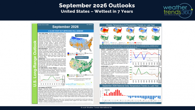
Sunny will be great for answering long range year-ahead questions, so let's start with September for Back2School. The U.S. trends the coolest in 3 years (similar to last year) but the wettest in 7 years. Canada trends every cooler - coolest in 6 years and wettest in 5 years,
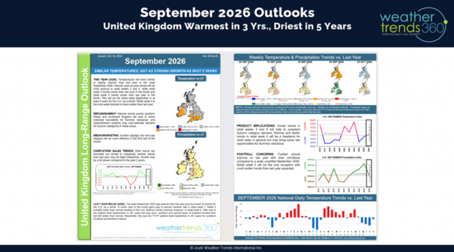
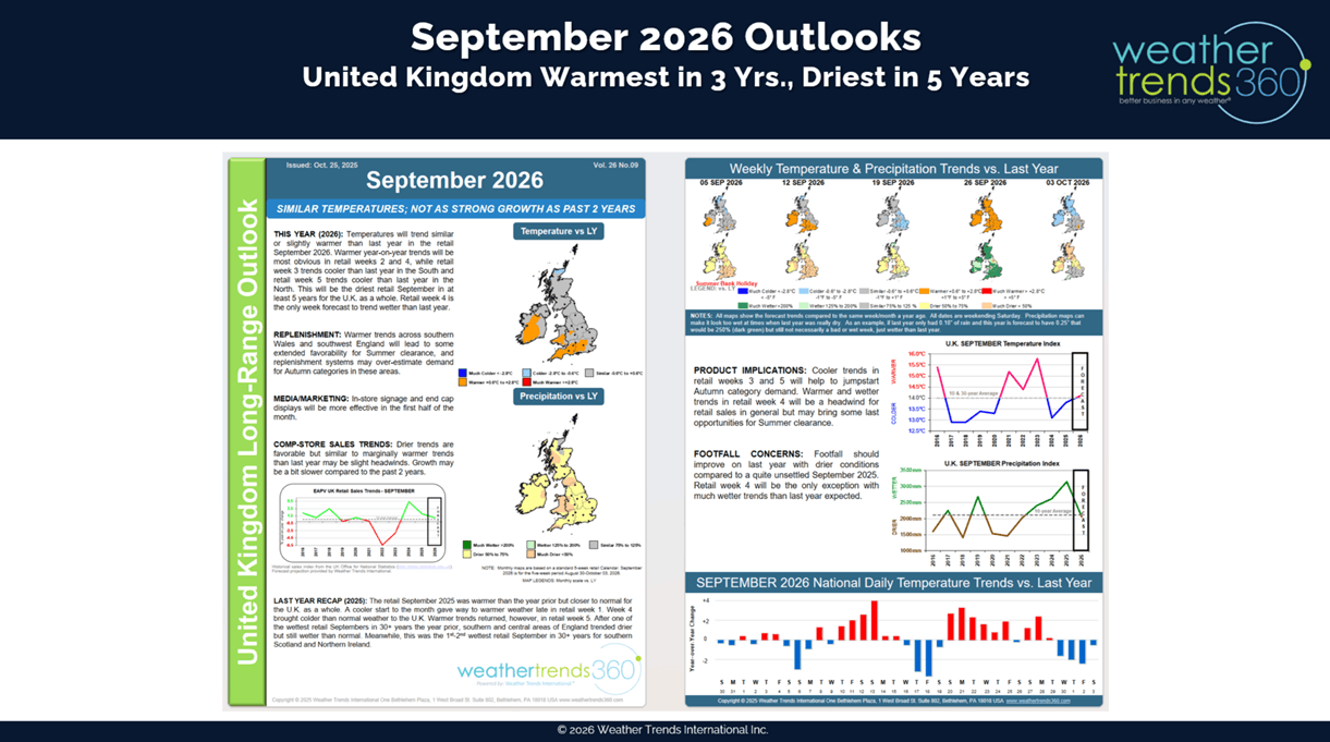
while the U.K. trends the warmest in 3 years and driest in 5 years. This time of year, cooler/wetter weather is better for back2school early Fall merchandise sales like apparel, coffee, heating accessories, humidifiers, etc.
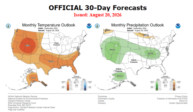
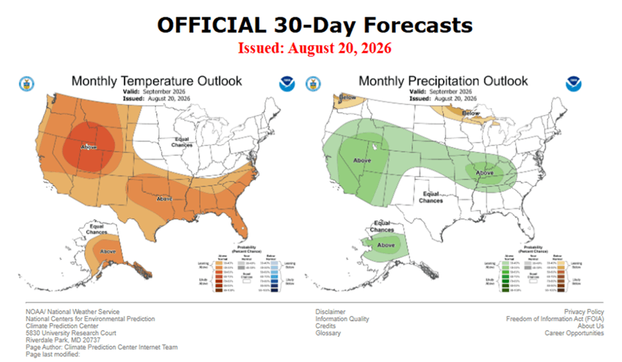
Not to pick on the U.S. government forecasts, aka NOAA (National Oceanic and Atmospheric Administration), but there's not a lot of value in general monthly outlooks without context. Below is the month ahead outlook for September from NOAA.
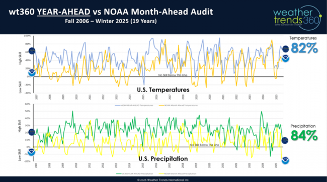
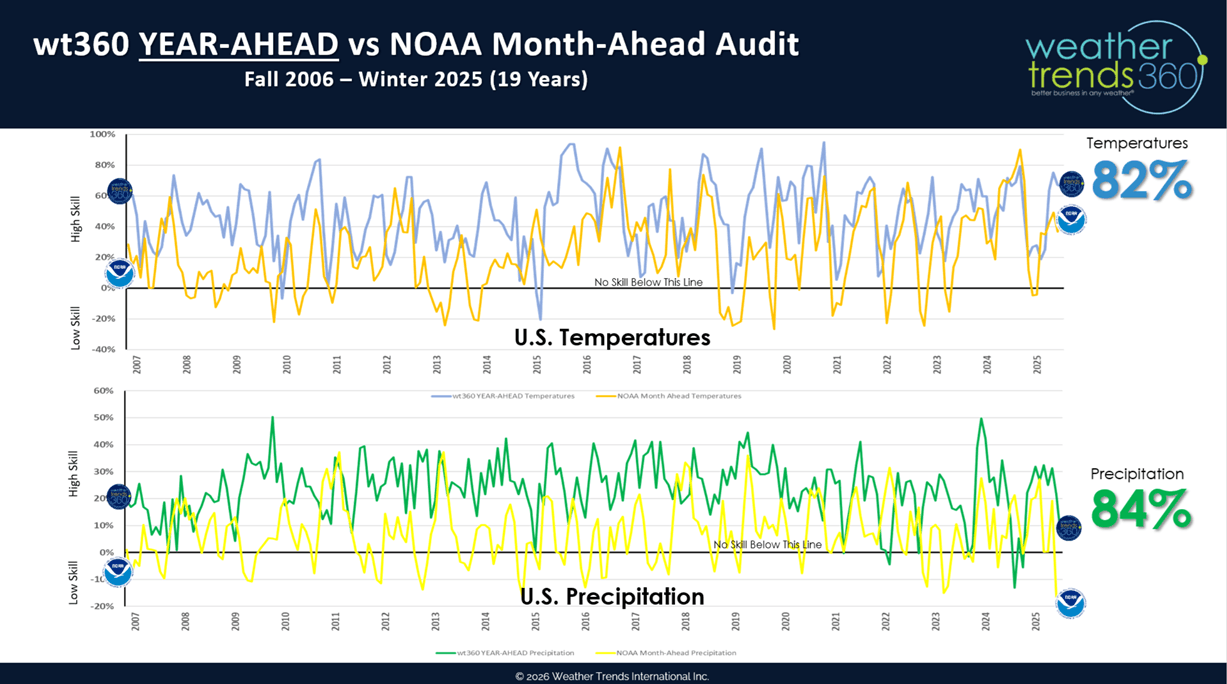
PhD Climatologists from West Point Military Academy and the University of Miami proved that weathertrends360's year-ahead forecasts outperform NOAA's month ahead forecasts 82% of the time on temperatures and 84% on precipitation despite being a year-ahead. You can read the full audit of the past 19 years here.
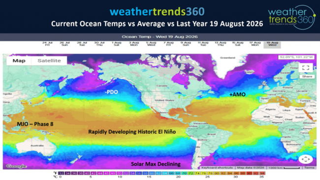
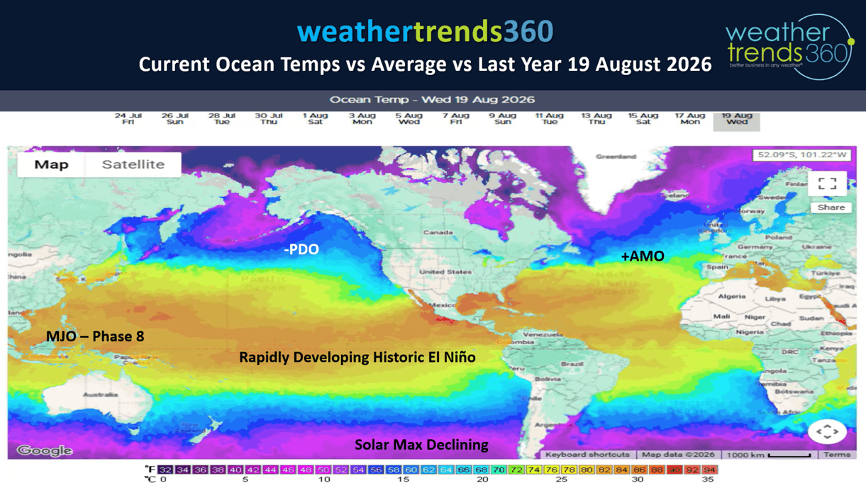
After assessing trillions upon trillions of statistical calculations, the other metrics in our year-ahead forecasting is climate cycles. El Niño is just one of those important cycles. El Nino is simply the warming of the Equatorial Pacific Ocean which creates significant rising air over North and South America and sinking air in Asia. Rising air = heavy rain, sinking air = droughts.
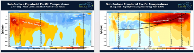
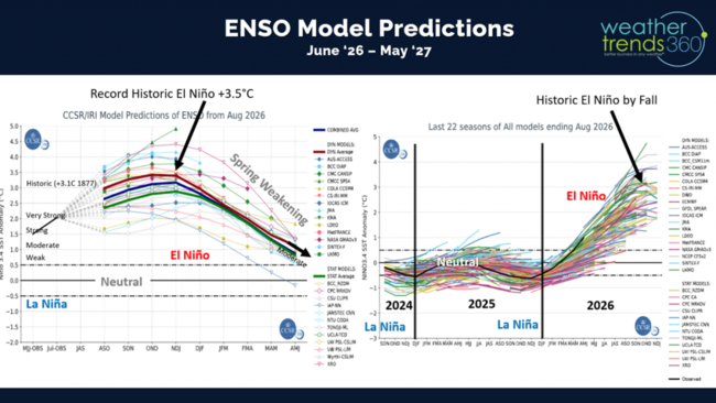
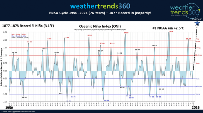
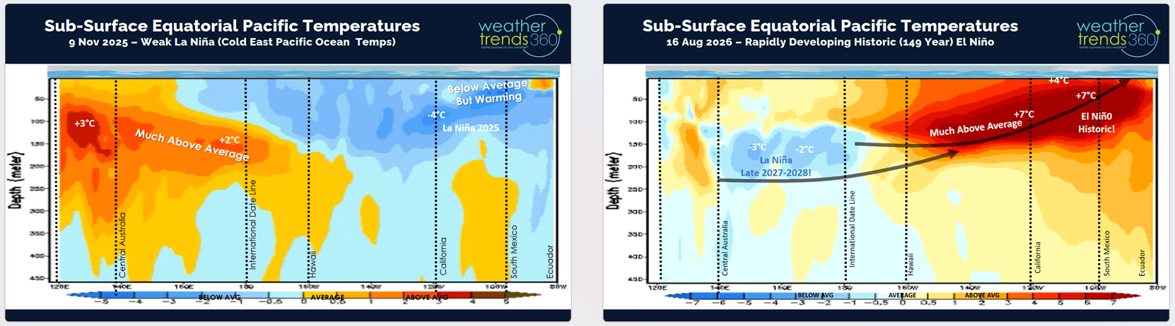
The change from La Niña (colder than average Pacific Ocean temperatures) this time last year to now a near certain strongest El Niño in at least 149 years will dominate the global weather patterns for the next 9 months. Looking hundreds of meters below the surface of the entire Pacific Ocean shows how we've quickly transitioned from cold to very warm Pacific Ocean temperatures.
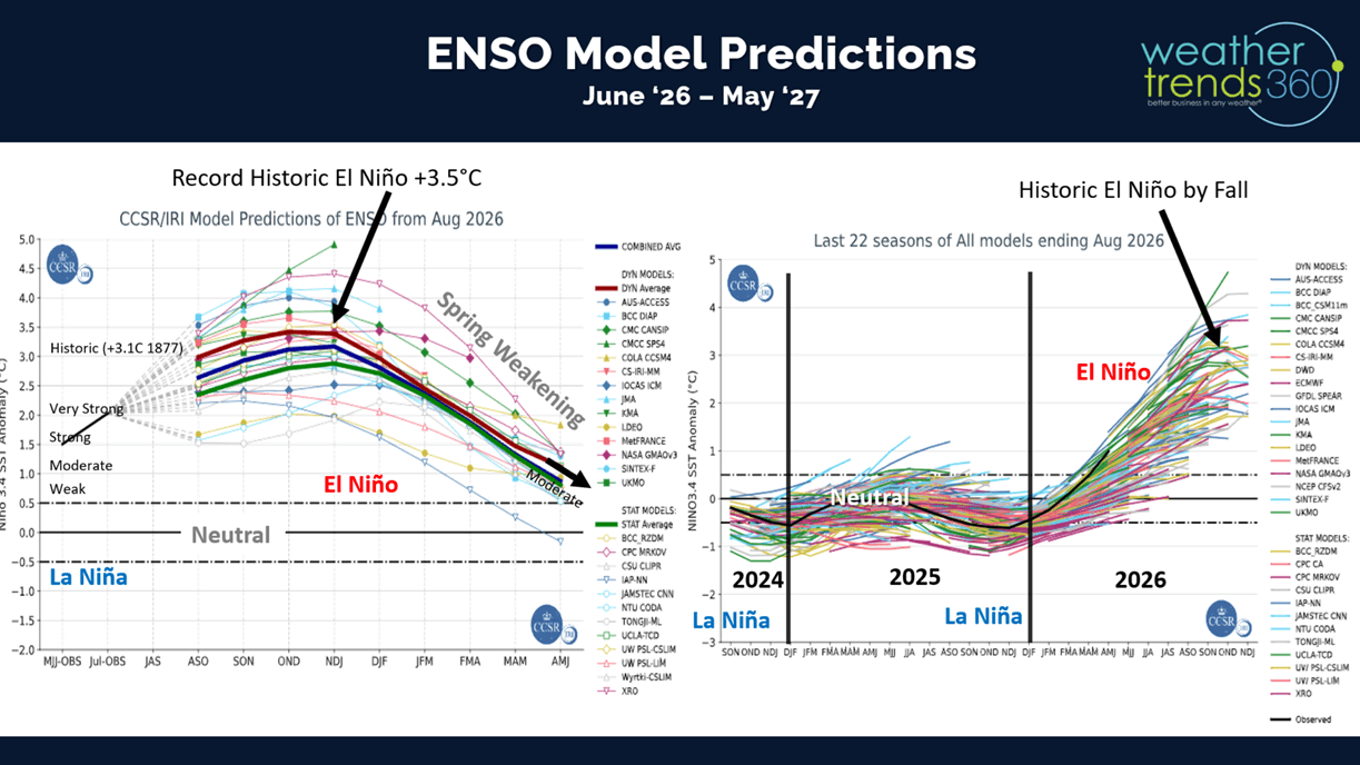
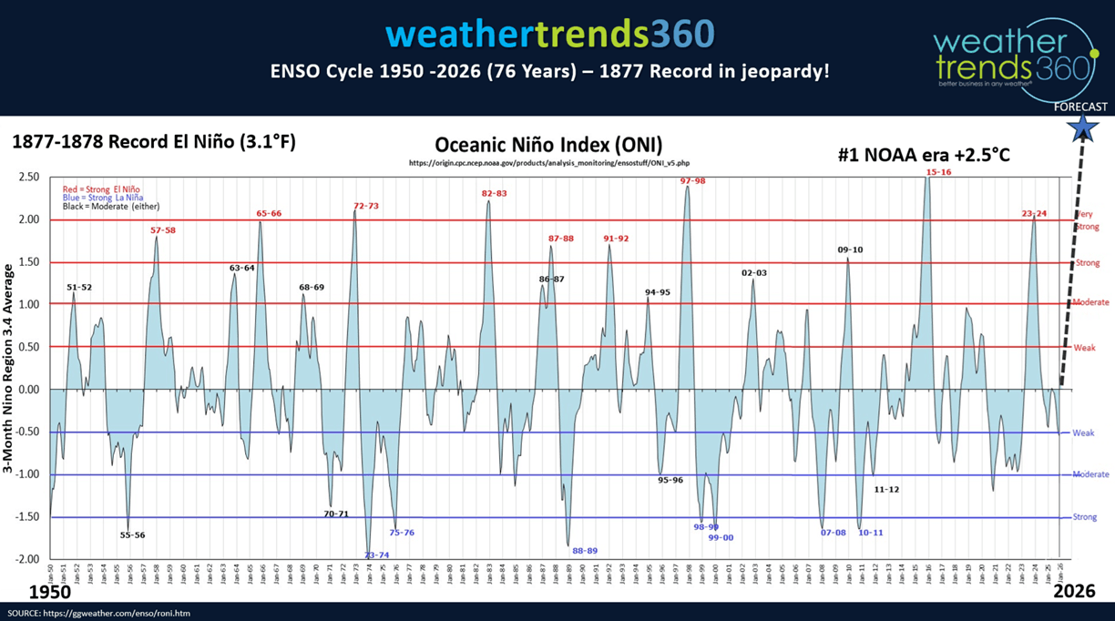
Not surprising the computer models made a big jump here in August with projections of +3.5C above average water temperatures which would crush the 1877 record of +3.1C for the strongest El Niño in recorded history.
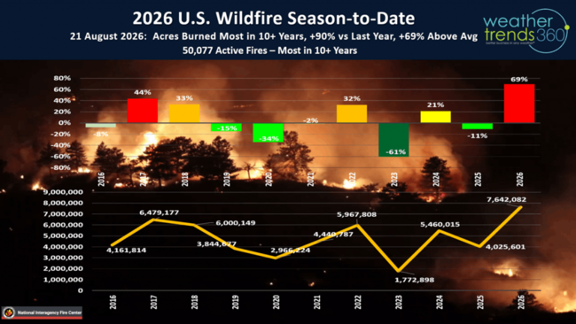
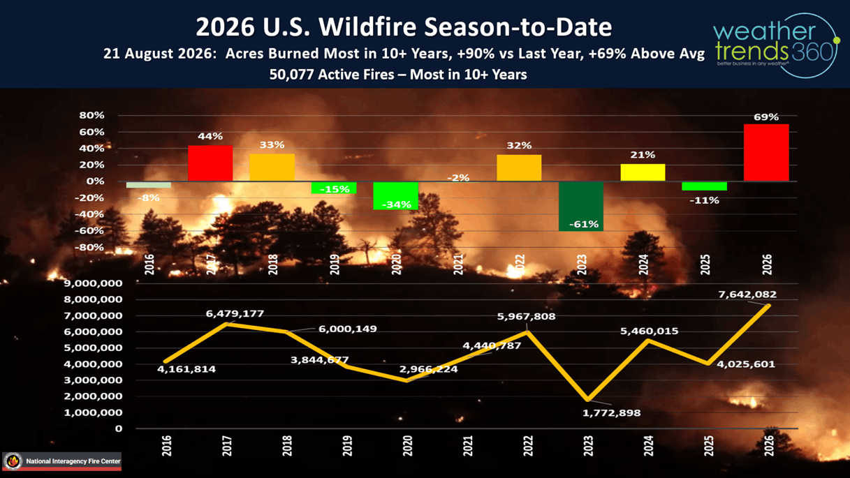
The extreme events of droughts, wildfires and no Atlantic hurricanes, will be replaced with major FLOOD events in the months ahead. Wildfires in the U.S. are the most in 10+ years with 50,077 active fires, 7.64 million acres burned which is +90% more than last year and +69% above average. These areas will be prone to mudslides this Winter in the West.
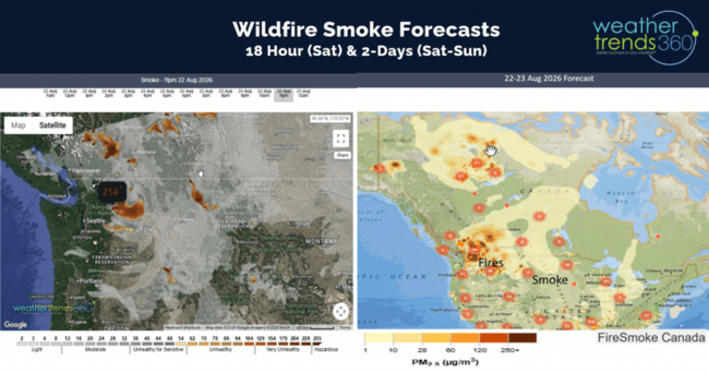
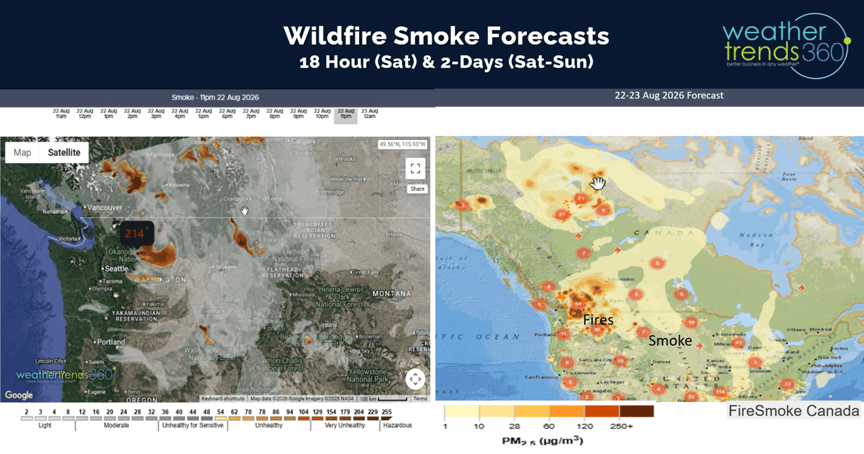
wt360 tracks fires with 18 hour smoke forecasts. Fortunately, there has been some improvement containing the big fires in the Northwest.
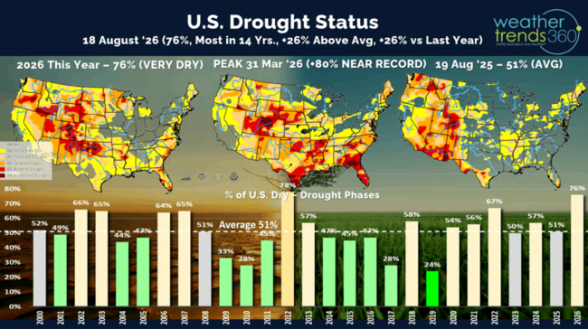
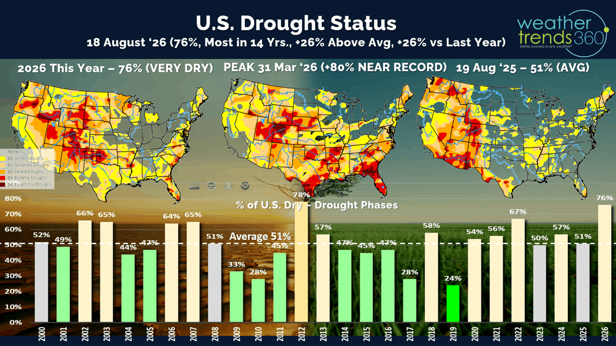
Drought is already showing signs of flipping with many states reporting major flooding events in the past couple months (IN, NC, AZ, TX, MO, PA, NJ, NY, WV). Drought metrics from NOAA are long-term events so they're not representative of the current, more recent wetter pattern. As of 18 August, they show 76% of the U.S. in dry to drought phases, most in 14 years, +26% above average and +26% above last year.
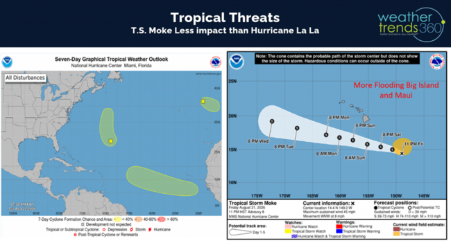
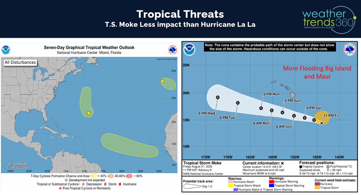
It's very common with El Nino's to have tropical storm threats to Hawaii where another system "Moke" will travel a bit farther away from the Islands than La La but still bringing some heavy flooding rains to the Big Island. The Atlantic has been suppressed by African dust and strong upper level windshear, but an MJO phase 8 might allow for a system to become our first hurricane but with little threat to the U.S.
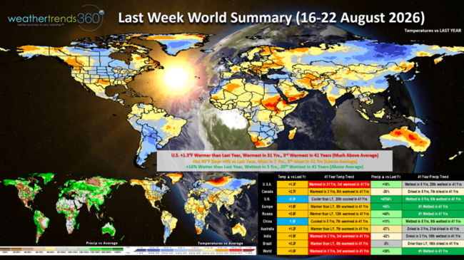
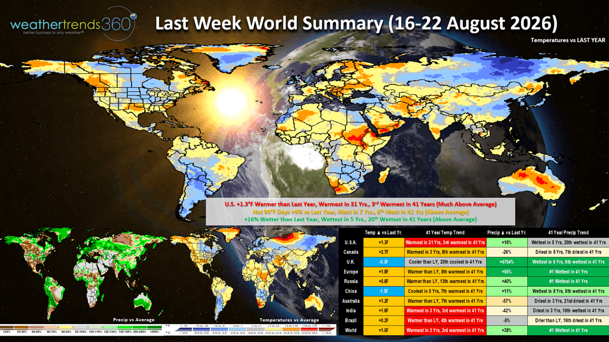
Last week (16-22 Aug) across the World shows the U.S. trending +1.3F warmer than last year, warmest in 33 years and 3rd warmest in 41 years. Hot 90F days were also up +4% vs LY, most in 7 years and 6th most in 41 years, while rainfall was up +16% vs LY, most in 5 years and 20th wettest of the past 41 years. These were overall negative trends for Fall back2school apparel categories, hot beverages and other early Fall merchandise. Cooler/wetter weather this time of year benefits most seasonal categories, except for home centers. Warm and Dry for Canada, very WET in the U.K., Europe and Russia and the World overall.
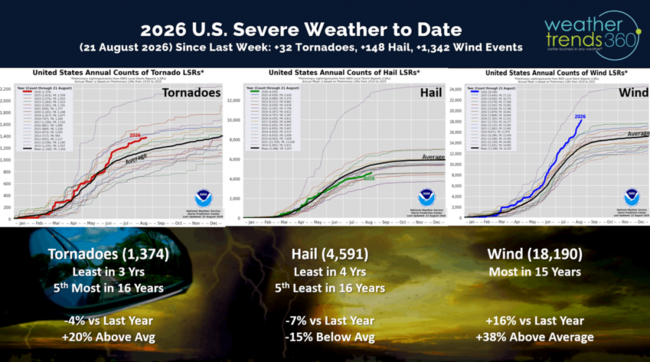
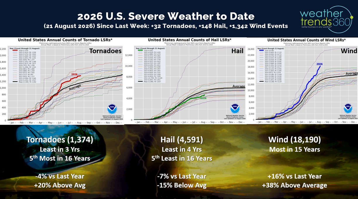
Last week there were 32 tornadoes, 148 hail events and a very significant 1,342 wind cases. Severe weather likely to see a major uptick this Fall due in part to El Nino.
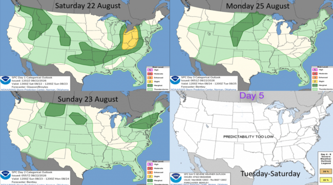
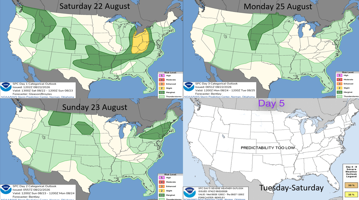
This week some minimal threats in the Ohio Valley where we don't need any more flooding rains.
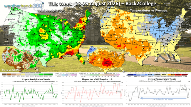
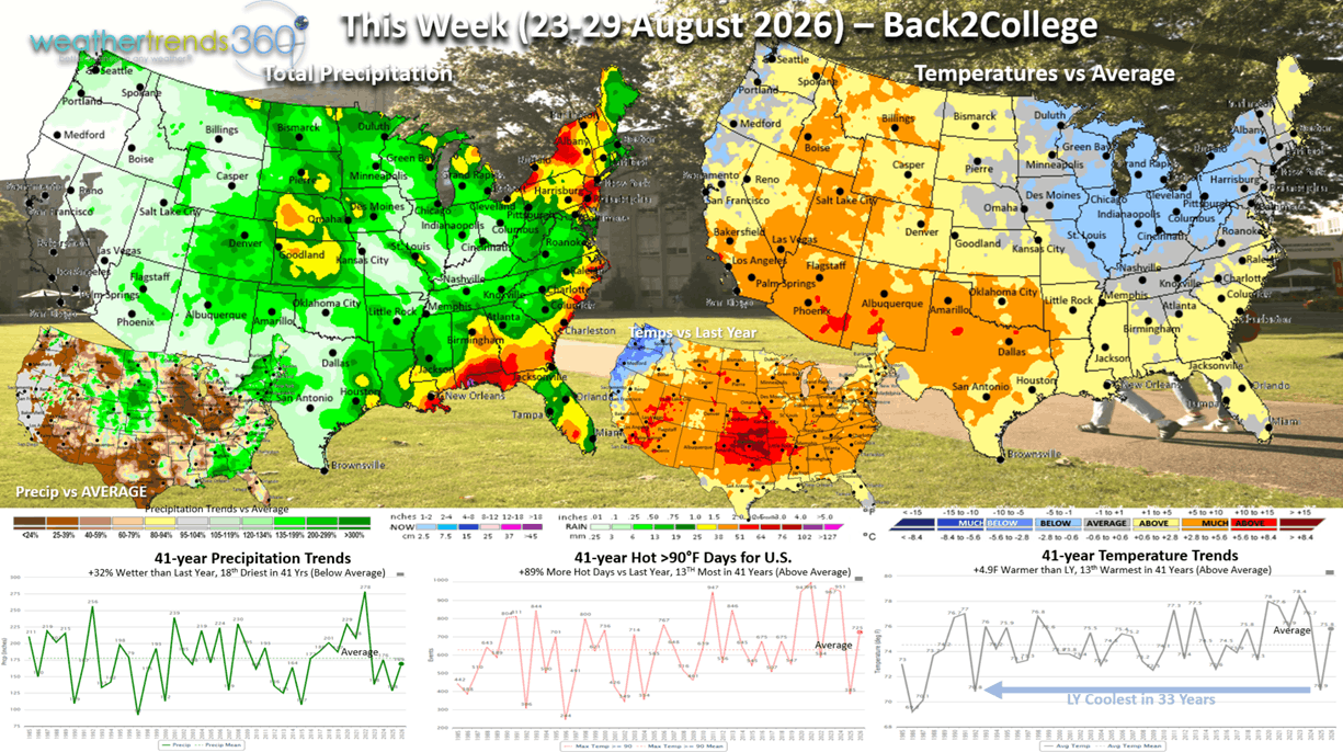
This week (23-29 Aug) is a big back2college period with the U.S. trending +4.9F warmer than last year (last year was the coldest in 33 years) and 13th warmest of the past 41 years. Hot 90F days also up +89% over last year and 13th most in 41 years, while rainfall is up +32% vs LY but 18th driest of the past 41 years. Even with the below average temperatures in the Midwest-Northeast, it's still much hotter than last year, a negative for apparel sales.
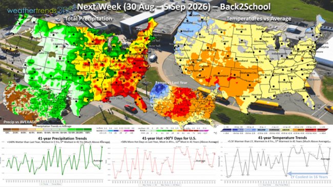
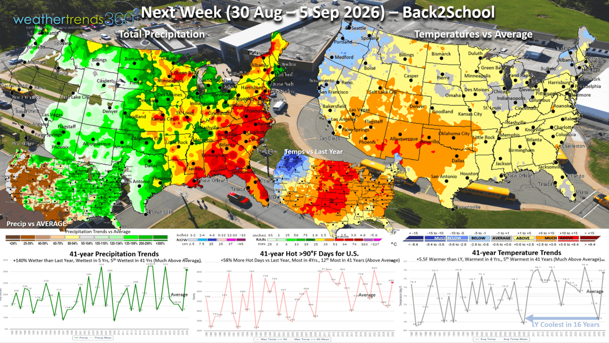
Next week (30 Aug - 5 Sep) is back2school for most and it trends even more unfavorable with temperatures +5.5F warmer than last year (last year coolest in 16 years), warmest in 4 years and 5th warmest in 41 years with much above average national temperatures. Hot 90F days way up +58% vs LY, most in 4 years and 12th most in 41 years, while rainfall makes a huge uptick +140% over last year, most in 5 years and 5th wettest in 41 years. Wet does help some back2school categories.
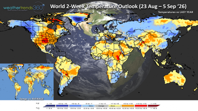
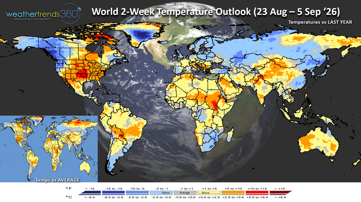
The World 2-week Temperature outlook (23 Aug - 5 Sep) shows a cooler Northwest U.S. and Canada, hot in the middle and cooler for Western Spain.
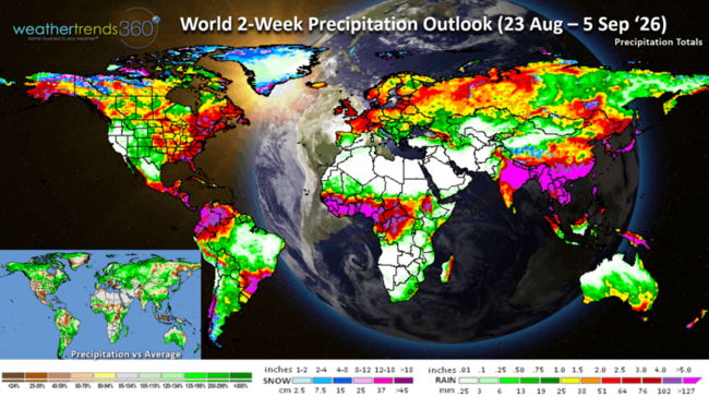
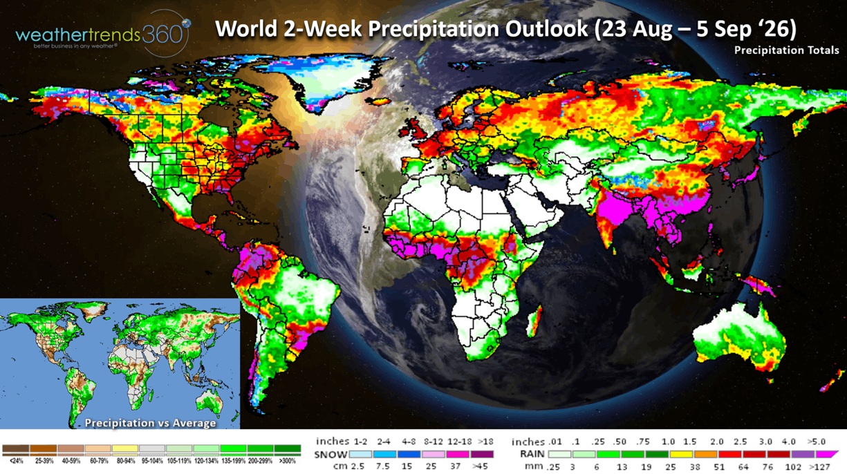
The World 2-week Precipitation outlook (23 Aug - 5 Sep) shows an increasingly wet pattern for the Eastern 2/3rds of the U.S. much of Europe, Russia and Brazil.
You can get this blog in your email inbox every weekend (FREE) via subscription.
Have a great week ahead, and don't forget to follow us on social media for updates: Facebook, Twitter(X), YouTube, Pinterest and Linkedin.
- Captain Kirk out (USAF Gulf War Veteran 1989-1999)
The countdown has started to the release of our super cool does everything AI weather and business app...in the stores 1 September (app name is weathertrends360)!
Sunny™ your AI weather companion will speak many languages with year-ahead intelligence on 360 equity stock indices, 220 seasonal category sales trends, 3 diseases (Asthma, Allergy, Flu) and weather intel for 32 million spots on Earth (that's every mile).
Watch the video
CLICK ON IMAGES FOR A LARGER VIEW

Let's ask Sunny for a summary of "meteorological" Summer which is 1 June - 31 August.
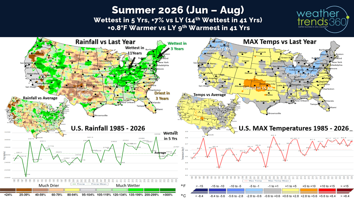
It's been a roller coaster Summer of up and down weather, but for the U.S. overall the season will trend the wettest in 5 years, +7% vs last year and 14th wettest of the past 41 years (above average). Temperatures trending +0.8F warmer than last year and 9th warmest of the past 41 years nationally. The U.S. Corn Belt/Ohio Valley is trending the coolest in 7 years and wettest in 11 years, while Oklahoma is the bullseye for heat with the hottest conditions in 15 years.
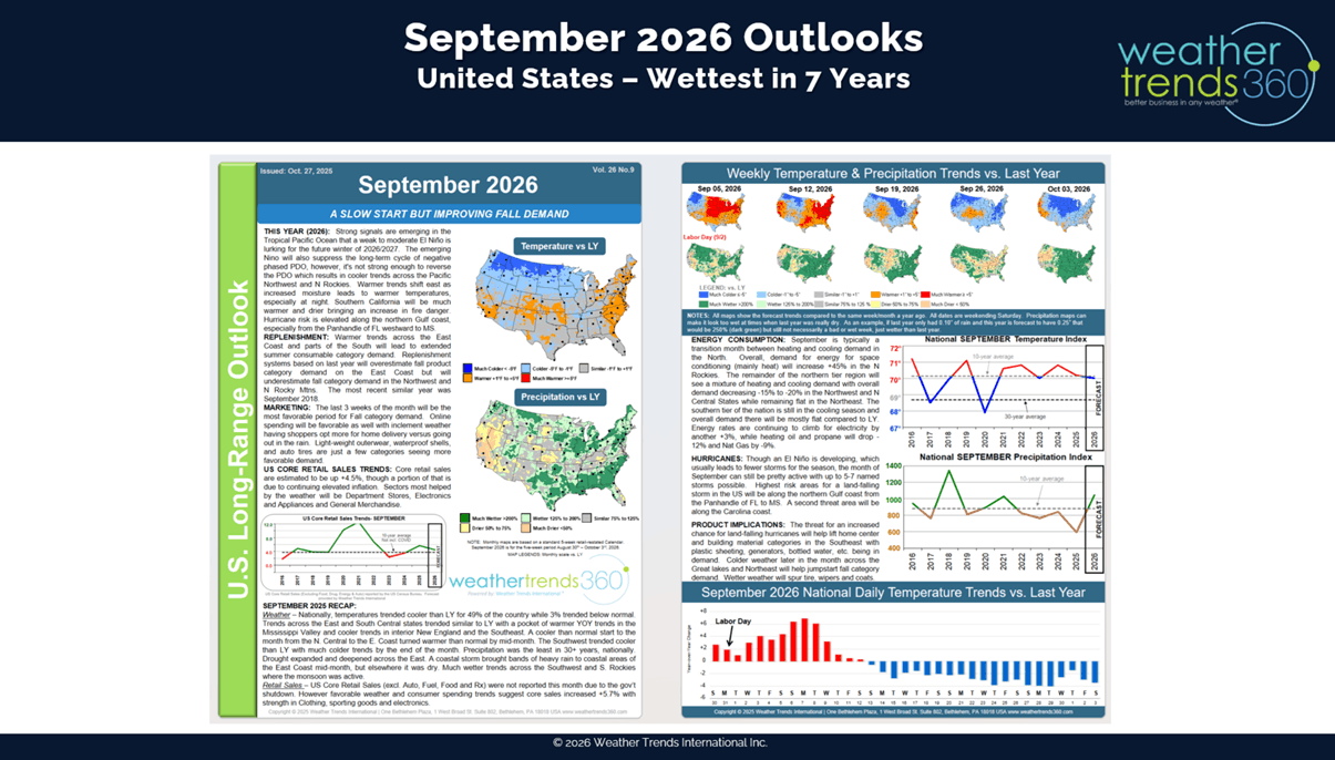
Sunny will be great for answering long range year-ahead questions, so let's start with September for Back2School. The U.S. trends the coolest in 3 years (similar to last year) but the wettest in 7 years. Canada trends every cooler - coolest in 6 years and wettest in 5 years,
while the U.K. trends the warmest in 3 years and driest in 5 years. This time of year, cooler/wetter weather is better for back2school early Fall merchandise sales like apparel, coffee, heating accessories, humidifiers, etc.
Not to pick on the U.S. government forecasts, aka NOAA (National Oceanic and Atmospheric Administration), but there's not a lot of value in general monthly outlooks without context. Below is the month ahead outlook for September from NOAA.
PhD Climatologists from West Point Military Academy and the University of Miami proved that weathertrends360's year-ahead forecasts outperform NOAA's month ahead forecasts 82% of the time on temperatures and 84% on precipitation despite being a year-ahead. You can read the full audit of the past 19 years here.
After assessing trillions upon trillions of statistical calculations, the other metrics in our year-ahead forecasting is climate cycles. El Niño is just one of those important cycles. El Nino is simply the warming of the Equatorial Pacific Ocean which creates significant rising air over North and South America and sinking air in Asia. Rising air = heavy rain, sinking air = droughts.
The change from La Niña (colder than average Pacific Ocean temperatures) this time last year to now a near certain strongest El Niño in at least 149 years will dominate the global weather patterns for the next 9 months. Looking hundreds of meters below the surface of the entire Pacific Ocean shows how we've quickly transitioned from cold to very warm Pacific Ocean temperatures.
Not surprising the computer models made a big jump here in August with projections of +3.5C above average water temperatures which would crush the 1877 record of +3.1C for the strongest El Niño in recorded history.
The extreme events of droughts, wildfires and no Atlantic hurricanes, will be replaced with major FLOOD events in the months ahead. Wildfires in the U.S. are the most in 10+ years with 50,077 active fires, 7.64 million acres burned which is +90% more than last year and +69% above average. These areas will be prone to mudslides this Winter in the West.
wt360 tracks fires with 18 hour smoke forecasts. Fortunately, there has been some improvement containing the big fires in the Northwest.
Drought is already showing signs of flipping with many states reporting major flooding events in the past couple months (IN, NC, AZ, TX, MO, PA, NJ, NY, WV). Drought metrics from NOAA are long-term events so they're not representative of the current, more recent wetter pattern. As of 18 August, they show 76% of the U.S. in dry to drought phases, most in 14 years, +26% above average and +26% above last year.
It's very common with El Nino's to have tropical storm threats to Hawaii where another system "Moke" will travel a bit farther away from the Islands than La La but still bringing some heavy flooding rains to the Big Island. The Atlantic has been suppressed by African dust and strong upper level windshear, but an MJO phase 8 might allow for a system to become our first hurricane but with little threat to the U.S.
Last week (16-22 Aug) across the World shows the U.S. trending +1.3F warmer than last year, warmest in 33 years and 3rd warmest in 41 years. Hot 90F days were also up +4% vs LY, most in 7 years and 6th most in 41 years, while rainfall was up +16% vs LY, most in 5 years and 20th wettest of the past 41 years. These were overall negative trends for Fall back2school apparel categories, hot beverages and other early Fall merchandise. Cooler/wetter weather this time of year benefits most seasonal categories, except for home centers. Warm and Dry for Canada, very WET in the U.K., Europe and Russia and the World overall.
Last week there were 32 tornadoes, 148 hail events and a very significant 1,342 wind cases. Severe weather likely to see a major uptick this Fall due in part to El Nino.
This week some minimal threats in the Ohio Valley where we don't need any more flooding rains.
This week (23-29 Aug) is a big back2college period with the U.S. trending +4.9F warmer than last year (last year was the coldest in 33 years) and 13th warmest of the past 41 years. Hot 90F days also up +89% over last year and 13th most in 41 years, while rainfall is up +32% vs LY but 18th driest of the past 41 years. Even with the below average temperatures in the Midwest-Northeast, it's still much hotter than last year, a negative for apparel sales.
Next week (30 Aug - 5 Sep) is back2school for most and it trends even more unfavorable with temperatures +5.5F warmer than last year (last year coolest in 16 years), warmest in 4 years and 5th warmest in 41 years with much above average national temperatures. Hot 90F days way up +58% vs LY, most in 4 years and 12th most in 41 years, while rainfall makes a huge uptick +140% over last year, most in 5 years and 5th wettest in 41 years. Wet does help some back2school categories.
The World 2-week Temperature outlook (23 Aug - 5 Sep) shows a cooler Northwest U.S. and Canada, hot in the middle and cooler for Western Spain.
The World 2-week Precipitation outlook (23 Aug - 5 Sep) shows an increasingly wet pattern for the Eastern 2/3rds of the U.S. much of Europe, Russia and Brazil.
You can get this blog in your email inbox every weekend (FREE) via subscription.
Have a great week ahead, and don't forget to follow us on social media for updates: Facebook, Twitter(X), YouTube, Pinterest and Linkedin.
- Captain Kirk out (USAF Gulf War Veteran 1989-1999)