wt360 Weather Brief 25 Apr '26: Cooler & Stormy Pattern Ahead
Captain's Log
25 Apr '26: Happy Saturday! :)
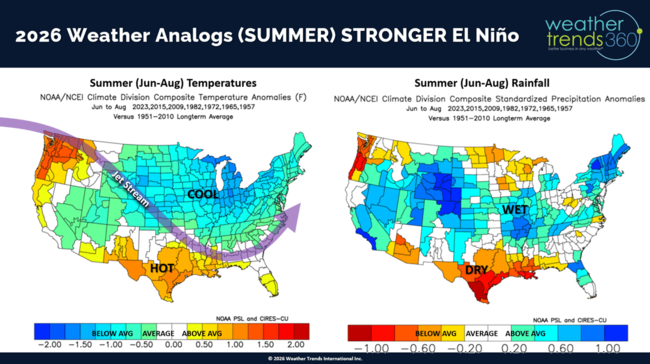
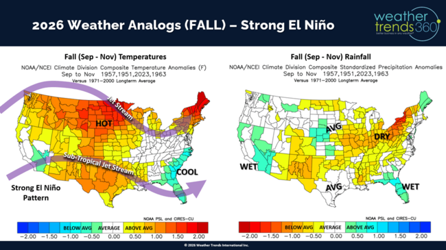
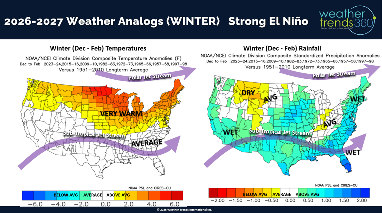
One method used by meteorologists to make longer range year-ahead outlooks is called the "analog", an assessment of current climate and oceanic indices mapped to the same patterns in the past 130 years to assume that same weather will repeat. It's not the method employed by wt360's year-ahead technology, but it at least gives a sense of what COULD happen if the weather responded like it did in the past. CLICK ON IMAGES FOR A LARGER VIEW.
Spring 2026 Analog
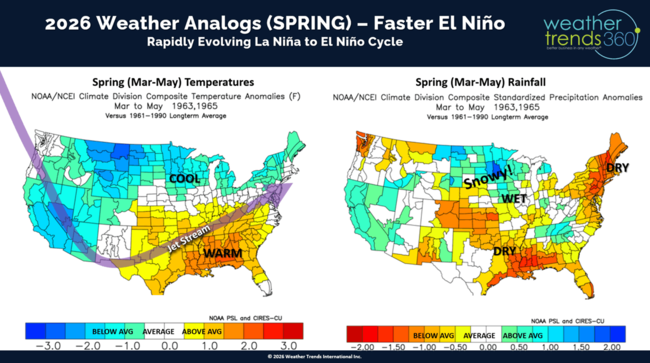
Looking at the emerging and potentially strong El Nino cycle (warming of the Equatorial Pacific Ocean) combined with other cycles like the Pacific Decadal Oscillation (PDO) Cycle, Atlantic Multi-Decadal Oscillation (AMO) Cycle, weakening Solar Max cycle, MJO Cycle, etc. we come up with these general Spring, Summer, Fall and Winter "analog" weather outlooks. To some extent this is starting to come into sync with a cooler/stormier late April - May pattern setting up in the U.S. vs the hot/dry pattern back in March.
Summer 2026 Analog
Fall 2026 Analog
Winter '26-'27 Analog

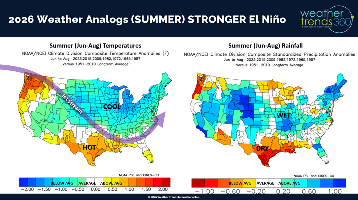
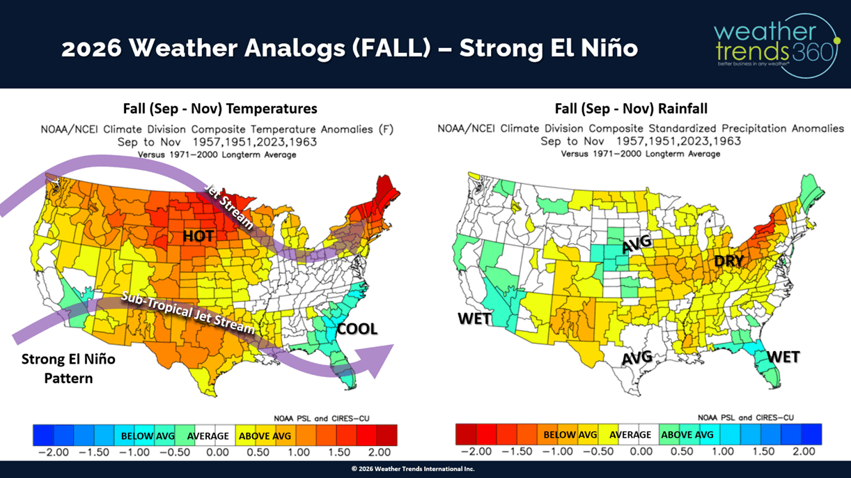
The official wt360 Year-Ahead forecast is generally in sync with these analogs through Summer, but we have the Fall much wetter, wettest in 8 years, for the U.S. overall. Winters tend to be very warm across the U.S. with rain cooled air for the South, but the overall Winter ahead pattern would be wet with larger Midwest and Nor'easter storms. Most of the Nor'easter would be WET vs WHITE, but it is common under this cycle to get one large snowstorm in an otherwise much less frequent snow event cycle. End analog climate cycle lesson. :)
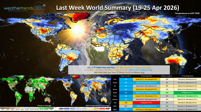
Last week (19-25 Apr) across the World, shows the U.S. trending -2.7F cooler than last year but 17th warmest of the past 41 years. The Northeast was very cool with a severe freeze, cooler in California and warm in the Central U.S. Hot 90F days up +19% vs LY and rainfall down -38% vs LY and 9th driest in 41 years. The Northeast was the least favorable spot for Spring merchandise sales, with the Central U.S. best. Continued cold and unfavorable across Canada and Eastern Europe. India was the hot spot - #1 hottest in over 41 years, while Russia was the #1 wettest/snowiest in over 41 years.
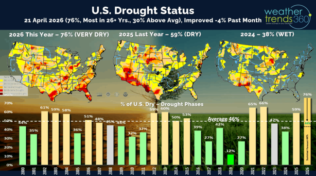
Drought made some minor improvement over the past month, but 76% of the U.S. is still in dry to drought phases with expanding drought in the Southeast and Western U.S. wt360 expects the El Nino cycle to make the U.S. very wet in the months ahead.

The wt360 Year-Ahead Spring Severe weather outlook added another 9th WIN with the late freeze forecast for the Midwest, Ohio Valley into the Middle Atlantic. Many areas on the 20th-21st had near 41-year record cold, we had 24F here in Eastern PA negatively impacting some vegetation and crops like strawberries. These severe weather reports are currently available through Winter '26-'27.
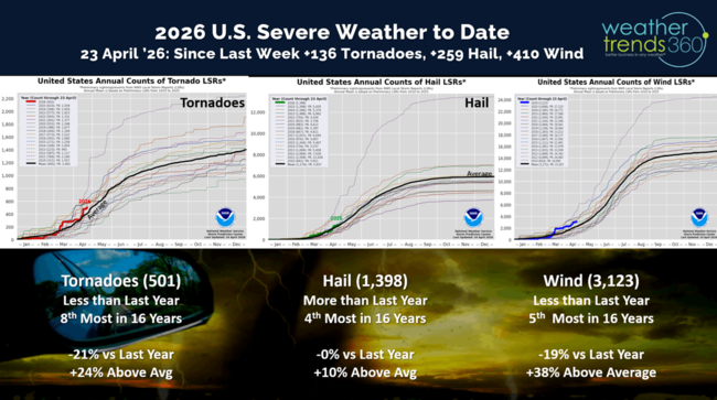
The past week was active on the Severe Weather front, adding 136 tornadoes, 259 hail events and 410 high wind events. All categories are trending down from last year, but still well above average for this point in the season.

The 4-day outlook from the Storm Prediction Center shows a very active few days ahead, especially from Oklahoma to Illinois.
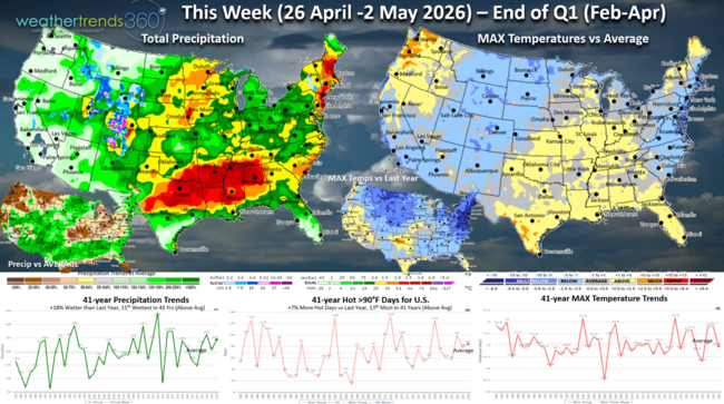
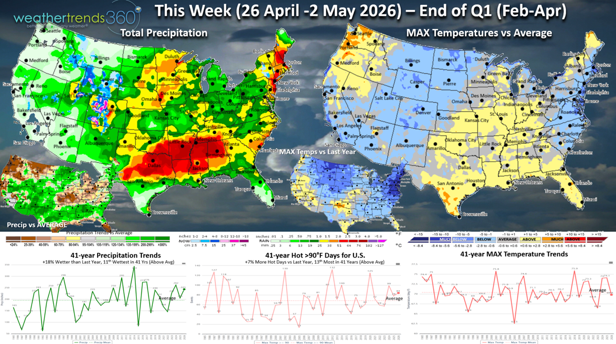
This Week (26 Apr - 2 May) is the last week of Q1 (Feb-Apr) for many retailers, and it's going out on a soft note. The week overall trends -4.3F cooler than last year, coolest in 3 years and 20th coolest of the past 41 years (below average nationally). Hot 90F day up +7% vs LY but limited to the Texas to Florida areas. Rainfall up +18% vs LY and 11th wettest of the past 41 years with a very stormy pattern. Snowfall is the most in 3 years but limited to the Central Rocky Mountains and some snow showers inland higher elevations of the Northeast. Some frost is again likely in parts of the Northeast. Overall, a downward trend for Spring seasonal merchandise sales.

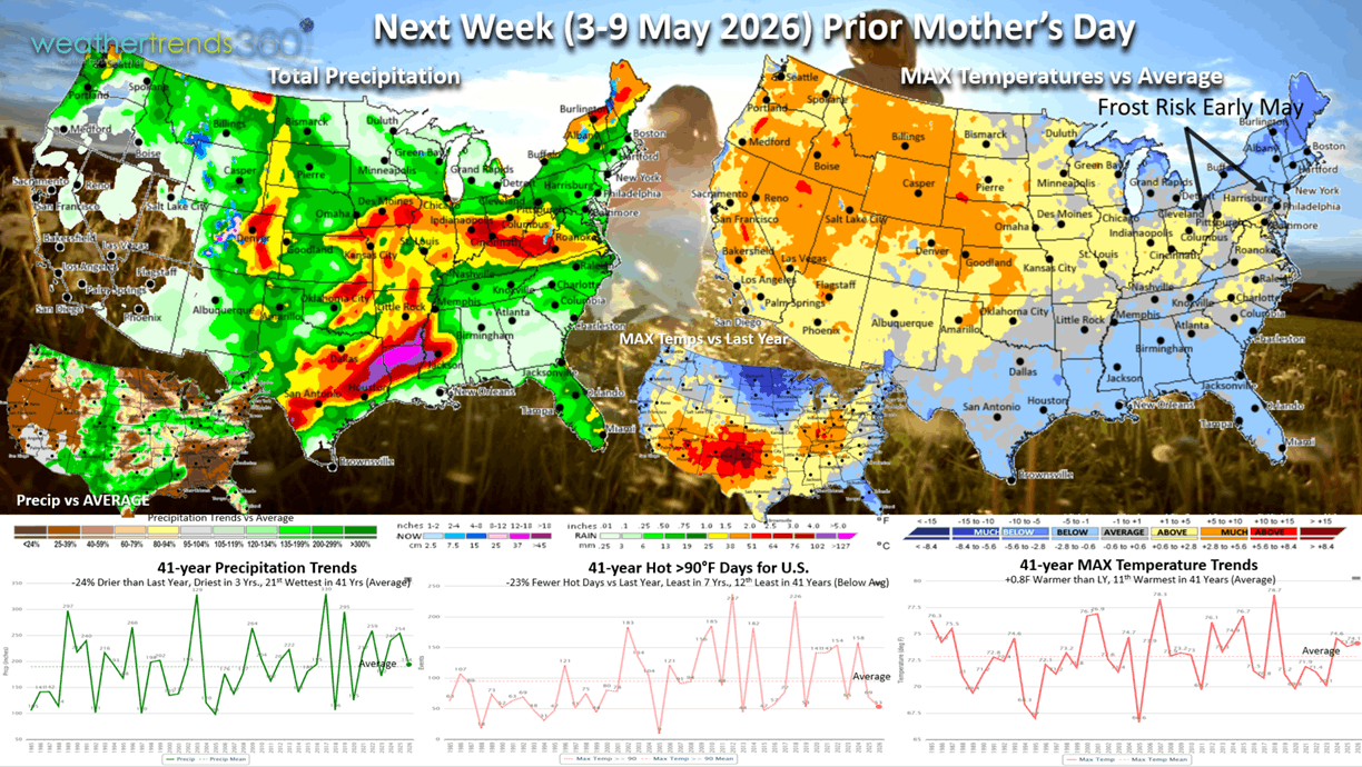
Next week (3-9 May) prior Mother's Day shows a warming trend for the Western half of the U.S., while the Northeast and immediate East Coast into Florida are cooler than typical and last year. While the U.S. overall trends +0.8F warmer than LY, the East Coast is the coolest in 3 years and below average which is generally unfavorable for Spring sales. There is another frost and freeze threat in early May for the Northeast. Hot 90F days nationally down -23% vs LY, least in 7 years and below average, while rainfall is down -24% vs LY, driest in 3 years but still 21st wettest (near average). The severe weather threat continues in the Central U.S., Midwest and Ohio Valley, while the Southeast continues to have drought.
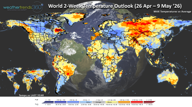
The World 2-week Temperature Outlook (26 Apr - 9 May) shows continued cooler across Canada, Northeast U.S. and Eastern Europe, but warmer Northwest U.S. - NW Canada and Western Europe. Brazil finally warming up and drying out.
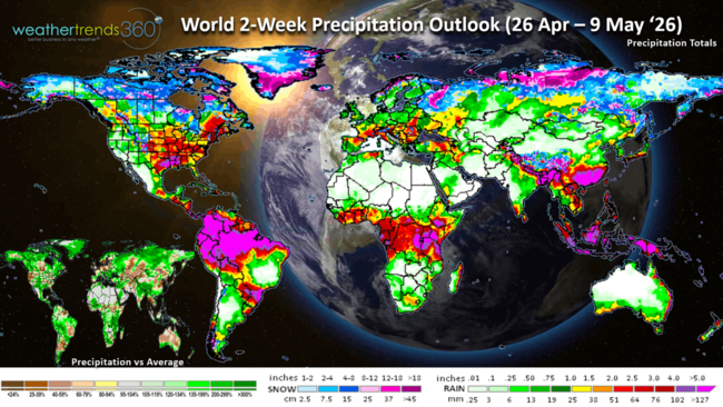
The World 2-week Precipitation Outlook (26 Apr - 9 May) shows a severe weather pattern for the Central U.S., some rain for the Southeast U.S. Northern Europe dry as is Central Brazil and Argentina crop regions, southern and NE Brazil coffee regions wet.
You can get this blog/video in your email inbox every Saturday (FREE) via subscription.
Have a great week ahead, and don't forget to follow us on social media for updates: Facebook, Twitter(X), YouTube, Pinterest and Linkedin.
- Captain Kirk out (USAF Gulf War Veteran 1989-1999)
One method used by meteorologists to make longer range year-ahead outlooks is called the "analog", an assessment of current climate and oceanic indices mapped to the same patterns in the past 130 years to assume that same weather will repeat. It's not the method employed by wt360's year-ahead technology, but it at least gives a sense of what COULD happen if the weather responded like it did in the past. CLICK ON IMAGES FOR A LARGER VIEW.
Spring 2026 Analog
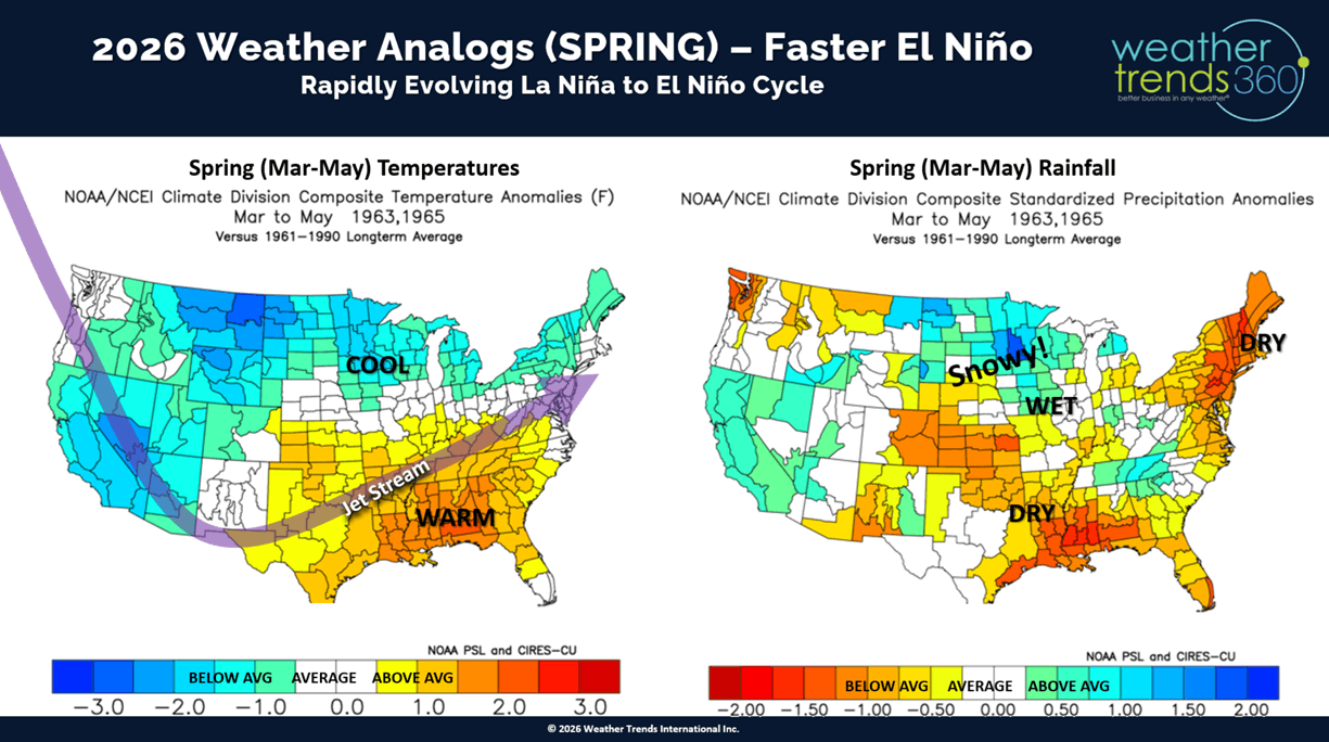
Looking at the emerging and potentially strong El Nino cycle (warming of the Equatorial Pacific Ocean) combined with other cycles like the Pacific Decadal Oscillation (PDO) Cycle, Atlantic Multi-Decadal Oscillation (AMO) Cycle, weakening Solar Max cycle, MJO Cycle, etc. we come up with these general Spring, Summer, Fall and Winter "analog" weather outlooks. To some extent this is starting to come into sync with a cooler/stormier late April - May pattern setting up in the U.S. vs the hot/dry pattern back in March.
Summer 2026 Analog
Fall 2026 Analog
Winter '26-'27 Analog
The official wt360 Year-Ahead forecast is generally in sync with these analogs through Summer, but we have the Fall much wetter, wettest in 8 years, for the U.S. overall. Winters tend to be very warm across the U.S. with rain cooled air for the South, but the overall Winter ahead pattern would be wet with larger Midwest and Nor'easter storms. Most of the Nor'easter would be WET vs WHITE, but it is common under this cycle to get one large snowstorm in an otherwise much less frequent snow event cycle. End analog climate cycle lesson. :)

Last week (19-25 Apr) across the World, shows the U.S. trending -2.7F cooler than last year but 17th warmest of the past 41 years. The Northeast was very cool with a severe freeze, cooler in California and warm in the Central U.S. Hot 90F days up +19% vs LY and rainfall down -38% vs LY and 9th driest in 41 years. The Northeast was the least favorable spot for Spring merchandise sales, with the Central U.S. best. Continued cold and unfavorable across Canada and Eastern Europe. India was the hot spot - #1 hottest in over 41 years, while Russia was the #1 wettest/snowiest in over 41 years.
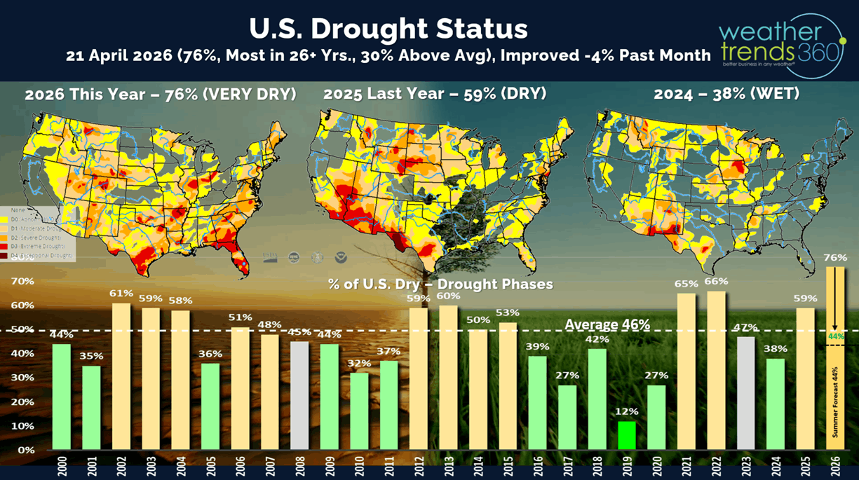
Drought made some minor improvement over the past month, but 76% of the U.S. is still in dry to drought phases with expanding drought in the Southeast and Western U.S. wt360 expects the El Nino cycle to make the U.S. very wet in the months ahead.
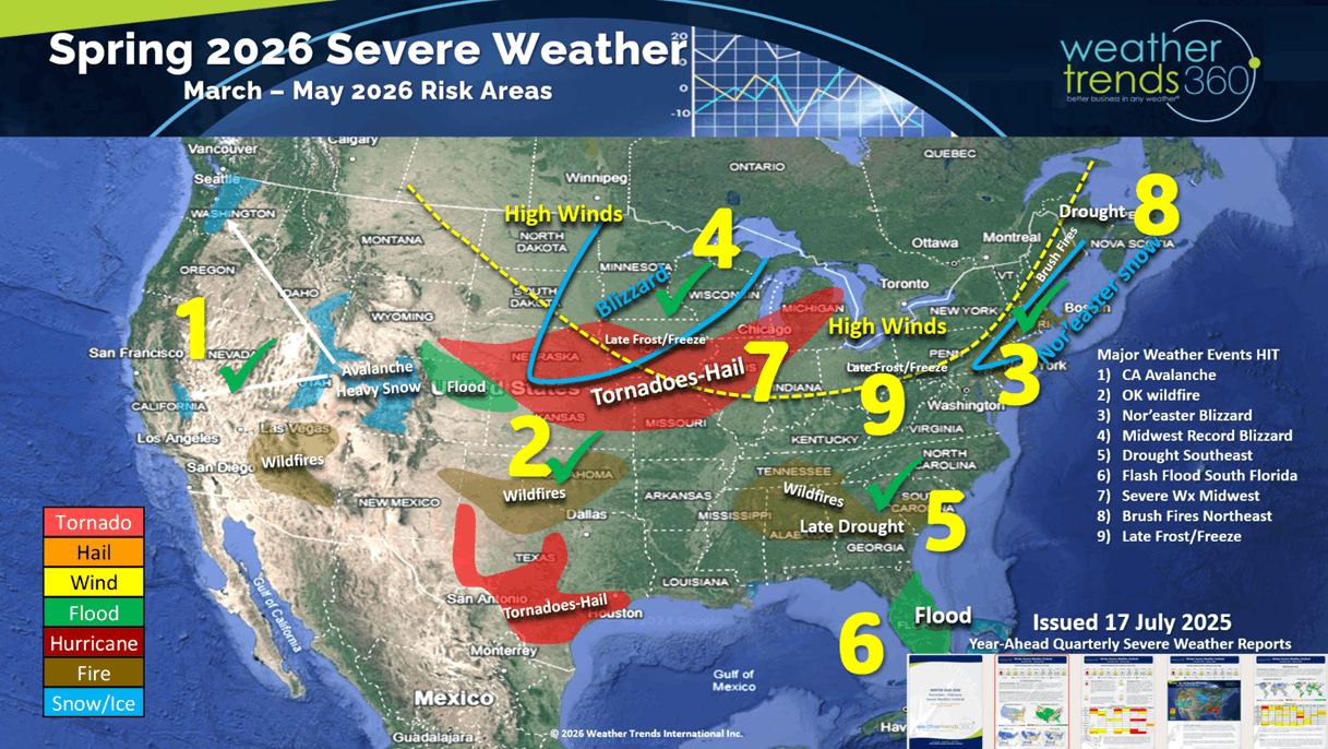
The wt360 Year-Ahead Spring Severe weather outlook added another 9th WIN with the late freeze forecast for the Midwest, Ohio Valley into the Middle Atlantic. Many areas on the 20th-21st had near 41-year record cold, we had 24F here in Eastern PA negatively impacting some vegetation and crops like strawberries. These severe weather reports are currently available through Winter '26-'27.
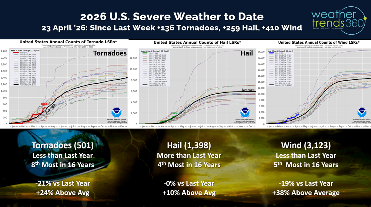
The past week was active on the Severe Weather front, adding 136 tornadoes, 259 hail events and 410 high wind events. All categories are trending down from last year, but still well above average for this point in the season.
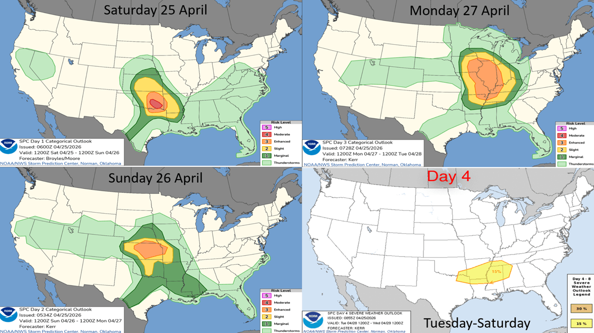
The 4-day outlook from the Storm Prediction Center shows a very active few days ahead, especially from Oklahoma to Illinois.
This Week (26 Apr - 2 May) is the last week of Q1 (Feb-Apr) for many retailers, and it's going out on a soft note. The week overall trends -4.3F cooler than last year, coolest in 3 years and 20th coolest of the past 41 years (below average nationally). Hot 90F day up +7% vs LY but limited to the Texas to Florida areas. Rainfall up +18% vs LY and 11th wettest of the past 41 years with a very stormy pattern. Snowfall is the most in 3 years but limited to the Central Rocky Mountains and some snow showers inland higher elevations of the Northeast. Some frost is again likely in parts of the Northeast. Overall, a downward trend for Spring seasonal merchandise sales.
Next week (3-9 May) prior Mother's Day shows a warming trend for the Western half of the U.S., while the Northeast and immediate East Coast into Florida are cooler than typical and last year. While the U.S. overall trends +0.8F warmer than LY, the East Coast is the coolest in 3 years and below average which is generally unfavorable for Spring sales. There is another frost and freeze threat in early May for the Northeast. Hot 90F days nationally down -23% vs LY, least in 7 years and below average, while rainfall is down -24% vs LY, driest in 3 years but still 21st wettest (near average). The severe weather threat continues in the Central U.S., Midwest and Ohio Valley, while the Southeast continues to have drought.

The World 2-week Temperature Outlook (26 Apr - 9 May) shows continued cooler across Canada, Northeast U.S. and Eastern Europe, but warmer Northwest U.S. - NW Canada and Western Europe. Brazil finally warming up and drying out.

The World 2-week Precipitation Outlook (26 Apr - 9 May) shows a severe weather pattern for the Central U.S., some rain for the Southeast U.S. Northern Europe dry as is Central Brazil and Argentina crop regions, southern and NE Brazil coffee regions wet.
You can get this blog/video in your email inbox every Saturday (FREE) via subscription.
Have a great week ahead, and don't forget to follow us on social media for updates: Facebook, Twitter(X), YouTube, Pinterest and Linkedin.
- Captain Kirk out (USAF Gulf War Veteran 1989-1999)