wt360 Weather Brief 25 Jul '26 Cool/Wet East, Hot/Dry West
Captain's Log
25 July 2026: Happy Saturday! :)
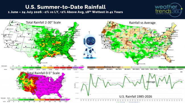
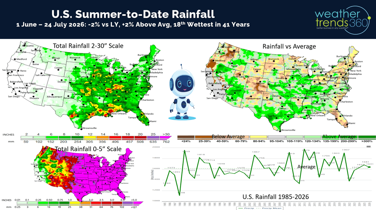
Let's ask wt360's robot "Sunny" about the Summer-to-date weather trends. Since 1 June through 24 July U.S. Rainfall is trending down -2% vs last year but still +2% above average and the 18th wettest of the past 41 years.
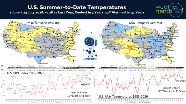
National temperatures are -0.2F cooler than last year, coolest in 3 years but still 12th warmest of the past 41 years. Hot 90F days are down -4% vs last year, least in 3 years but 10th most in 41 years. CLICK ON IMAGES FOR A LARGER VIEW
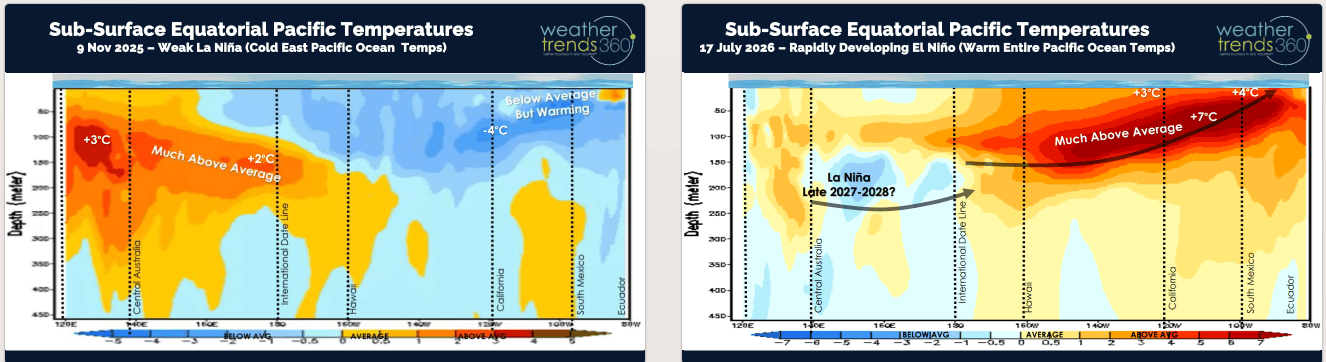
El Niño continues to strengthen rapidly with much above average Equatorial Pacific Ocean temperatures.
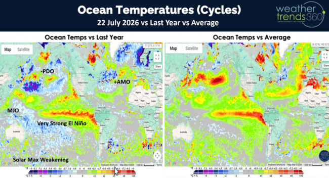
The change in temperatures from La Niña (cold waters) last Fall to now El Niño's very warm waters is pretty remarkable as we head toward a 149 year historic event. But notice that below normal ocean temperatures several hundred meters below the surface toward Australia...that's a sign of the next major climate cycle shift toward La Niña by late 2027 next year. So, a rapidly evolving and volatile weather pattern ahead.
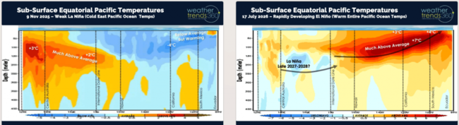
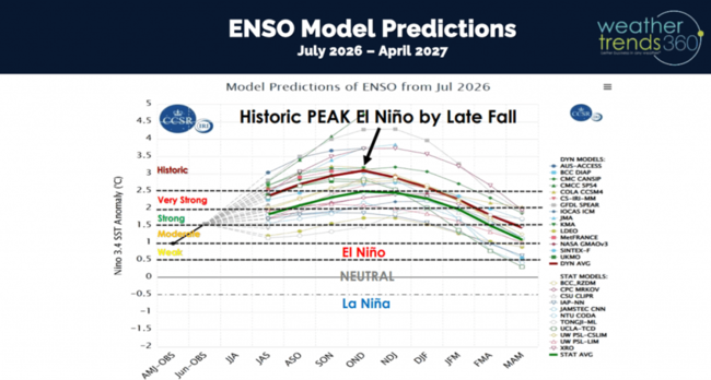
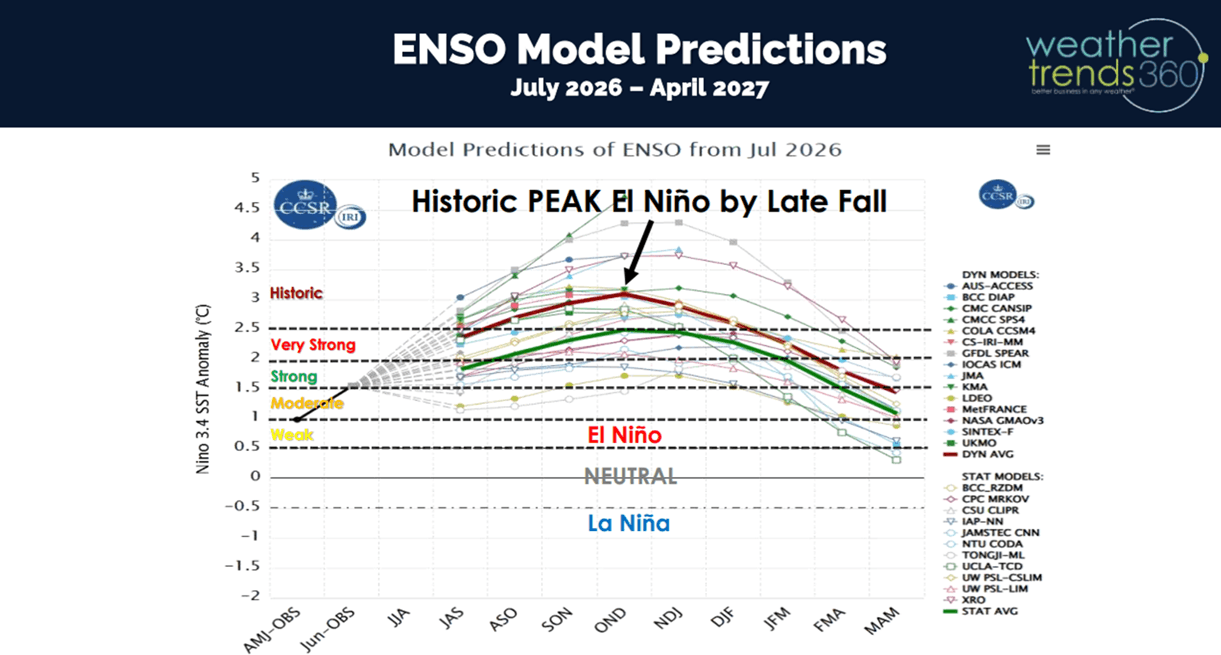
Models show El Niño peaking around November to an historic +3.1C above average water temperatures which would match the #1 event way back in 1877.
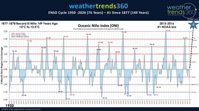
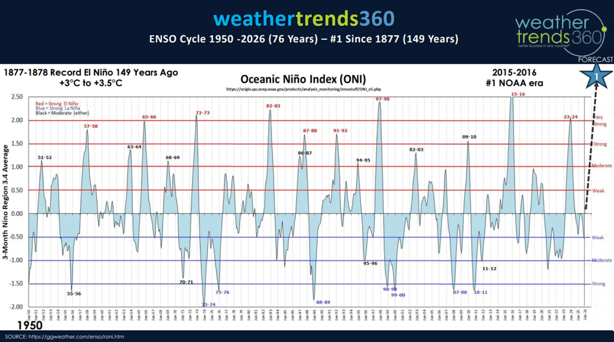
The modern era peak El Niño was 2015 when the ocean temperature anomaly was +2.5C, we will surge way past that!
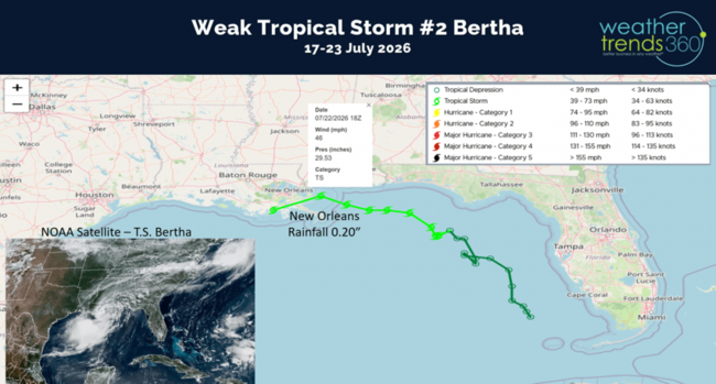
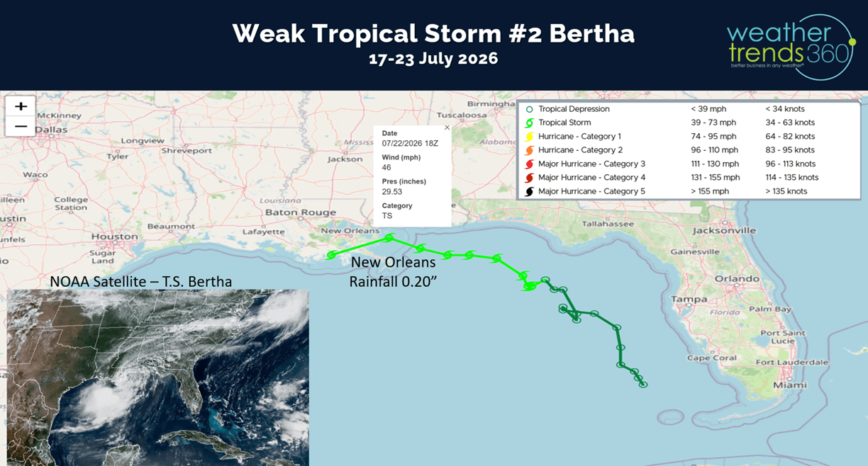
One benefit of an El Nino pattern is the wind shear it creates across the Gulf of Mexico, Caribbean and Atlantic which suppresses tropical activity. We did get our 2nd weak Tropical Storm Bertha of the season that grazed the Northern Gulf of Mexico with very little impact. New Orleans was the closest city to a landfall, and they only got 0.20" of rain and minimal wind.
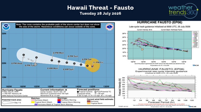
El Nino's do make Pacific basin more active, and we already see a minimal threat to Hawaii with a weakening Hurricane Fausto. This will likely be a Tropical Storm as it passes North of the Hawaiian Island chain Tuesday. The south side of the storm is the weakest, so the impact is expected to be very minimal.
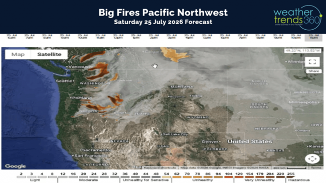
We've added a new 18 hour wild fire/smoke forecast mapping tool to wt360.com. Today's forecast shows the big timber fires burning out west bringing unhealthy pollution to areas in the Pacific Northwest.
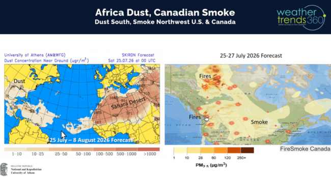
It's not smoke, but Sahara Africa dust that's invading the Deep South. This also helps to suppress any tropical activity in the Atlantic. Fortunately, recent rains in Ontario have helped to suppress the big fires, but they're still raging in the Northwest Territories.
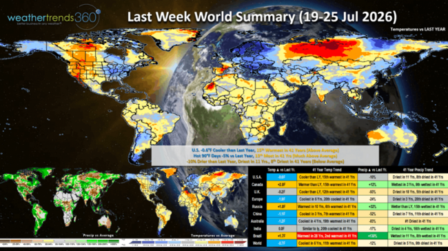
Last week (19-25 July) across the World shows the U.S. trending -0.6F cooler than last year and 15th warmest of the past 41 years. Very cool conditions in the East with some mornings dipping into the 40s and 50s. Hot 90F days nationally were down -5% vs last year and 13th most in 41 years. Rainfall was down -10% vs last year, driest in 11 years and 8th driest in 41 years. This time of year, we start to transition where cold/wet is better for retailers as they start to roll out Back2School merchandise. Europe got a much needed reprieve from the heat! Extremely dry across Australia but wettest in 11 years for Brazil.
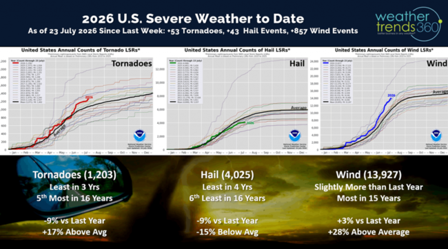
The U.S. added 53 tornadoes last week, only 43 hail events but a more significant 857 wind events. Season to date is still trending down for tornadoes and hail vs last year, but tornadoes and wind cases are still well above average, especially wind which is the most in 15 year.
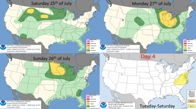
This week the severe weather threat is along the northern border moving into the Great Lakes and Middle Atlantic early in the week.
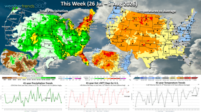
This week (26 Jul - 1 Aug) shows continued cool and wet conditions along the East Coast, hot in the Central U.S. and Rockies with little if any rainfall relief for the fires in the Northwest. Florida likely to get some much needed rain. The U.S. overall trends +1.8F warmer than last year, 3rd warmest in 41 years, hot 90F days up +4% vs last year, 12th most in 41 years, while rainfall is down -23% vs LY, least in 27 years and 6th least in 41 years. Cooler/Wetter is the more favorable weather for back2school sales with kids starting school in early to middle August across the South.
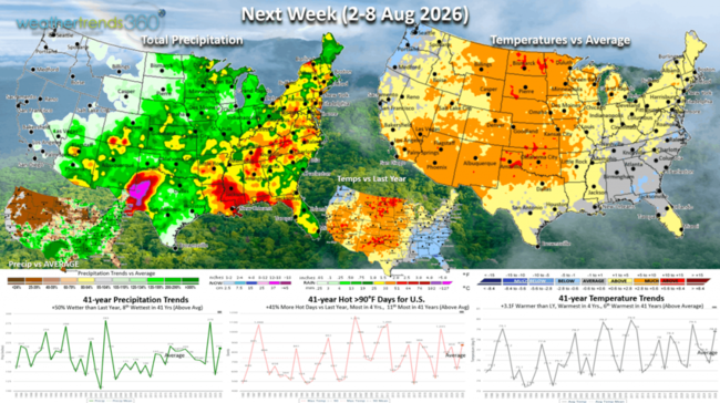
Next week (2-8 Aug) shows temperatures warming in the Northeast but still cooler/wetter in the Southeast. Hottest conditions in the Central Plains. The U.S. overall trends +3.1F warmer than last year, warmest in 4 yrs and 6th warmest of the past 41 years. Hot 90F days are up +41% vs LY, most in 4 yrs and 11th most in 41 years, while rainfall is up +50% vs LY and 8th wettest of the past 41 years. Still no rain for the West Coast so the wildfire risk will increase!
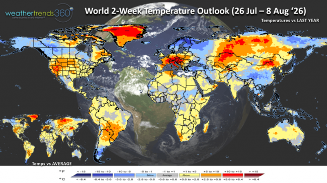
The World 2-week Temperature Outlook (26 Jul - 8 Aug) shows cool conditions for Alaska and Northern Canada, Northern Europe and Southern China. Hot conditions return to Central Europe and the Southwest U.S. Northern Plains.
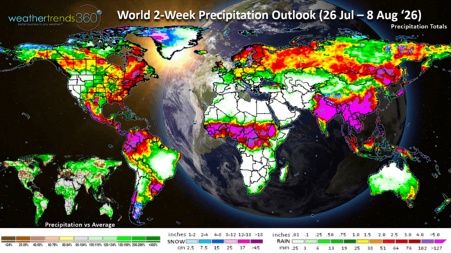
The World 2-week Precipitation Outlook (26 Jul - 8 Aug) shows the Eastern U.S. the wet spot but very dry across most of Europe. Wetter weather returns to Australia for their mid-Winter period.
You can get this blog in your email inbox every weekend (FREE) via subscription.
Have a great week ahead, and don't forget to follow us on social media for updates: Facebook, Twitter(X), YouTube, Pinterest and Linkedin.
- Captain Kirk out (USAF Gulf War Veteran 1989-1999)
Let's ask wt360's robot "Sunny" about the Summer-to-date weather trends. Since 1 June through 24 July U.S. Rainfall is trending down -2% vs last year but still +2% above average and the 18th wettest of the past 41 years.
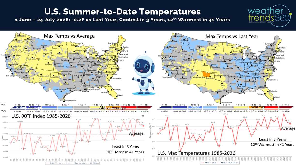
National temperatures are -0.2F cooler than last year, coolest in 3 years but still 12th warmest of the past 41 years. Hot 90F days are down -4% vs last year, least in 3 years but 10th most in 41 years. CLICK ON IMAGES FOR A LARGER VIEW
El Niño continues to strengthen rapidly with much above average Equatorial Pacific Ocean temperatures.
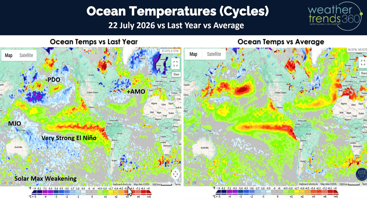
The change in temperatures from La Niña (cold waters) last Fall to now El Niño's very warm waters is pretty remarkable as we head toward a 149 year historic event. But notice that below normal ocean temperatures several hundred meters below the surface toward Australia...that's a sign of the next major climate cycle shift toward La Niña by late 2027 next year. So, a rapidly evolving and volatile weather pattern ahead.
Models show El Niño peaking around November to an historic +3.1C above average water temperatures which would match the #1 event way back in 1877.
The modern era peak El Niño was 2015 when the ocean temperature anomaly was +2.5C, we will surge way past that!
One benefit of an El Nino pattern is the wind shear it creates across the Gulf of Mexico, Caribbean and Atlantic which suppresses tropical activity. We did get our 2nd weak Tropical Storm Bertha of the season that grazed the Northern Gulf of Mexico with very little impact. New Orleans was the closest city to a landfall, and they only got 0.20" of rain and minimal wind.
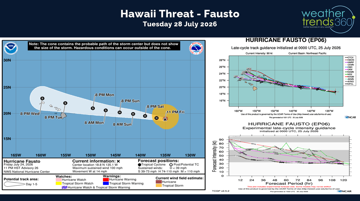
El Nino's do make Pacific basin more active, and we already see a minimal threat to Hawaii with a weakening Hurricane Fausto. This will likely be a Tropical Storm as it passes North of the Hawaiian Island chain Tuesday. The south side of the storm is the weakest, so the impact is expected to be very minimal.
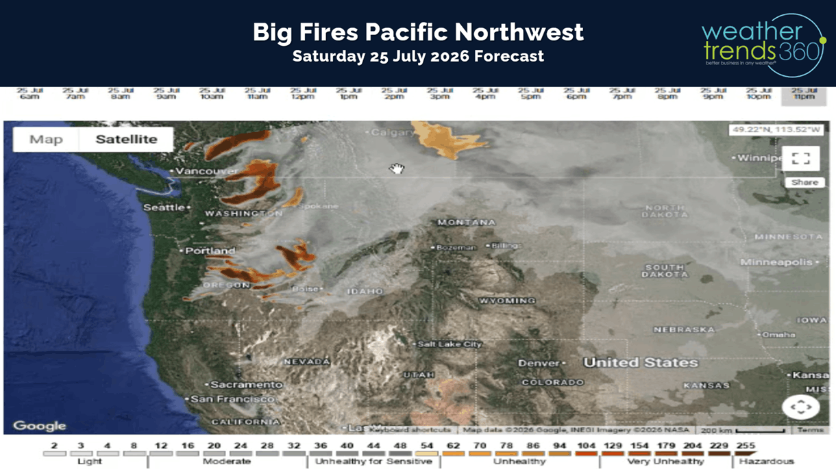
We've added a new 18 hour wild fire/smoke forecast mapping tool to wt360.com. Today's forecast shows the big timber fires burning out west bringing unhealthy pollution to areas in the Pacific Northwest.
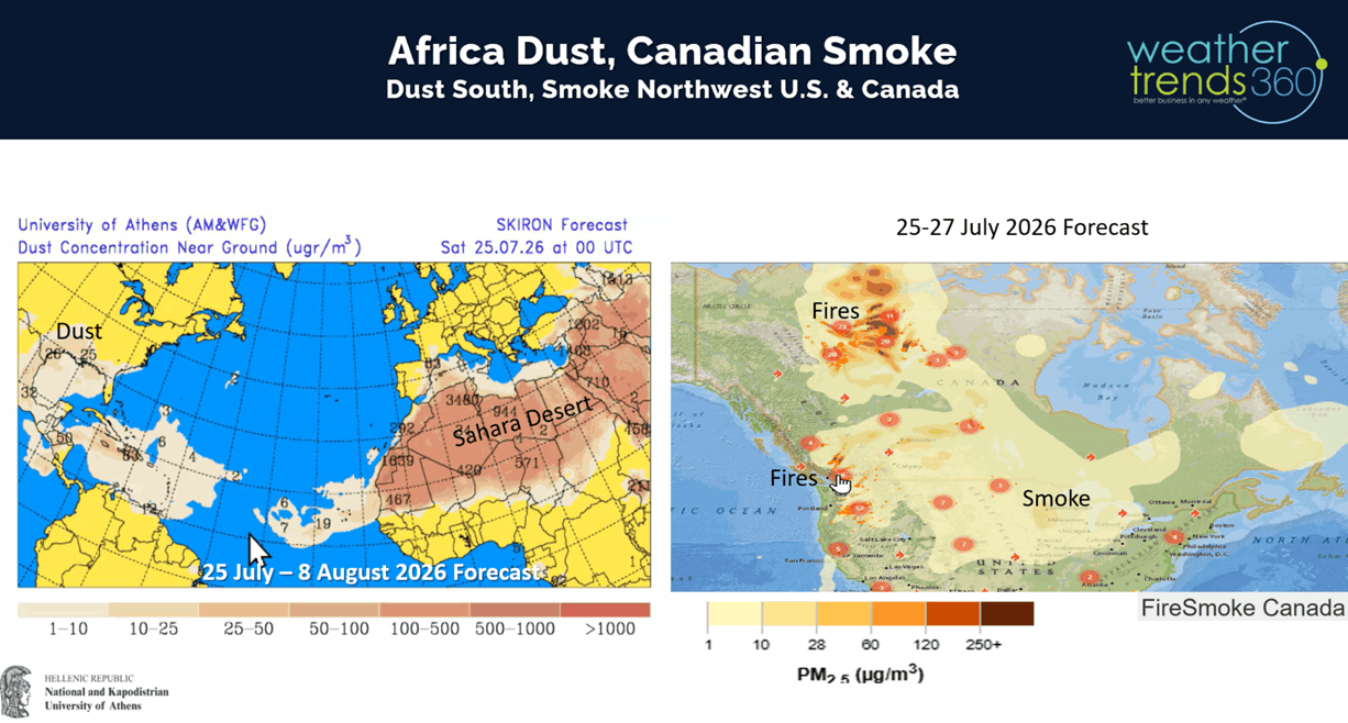
It's not smoke, but Sahara Africa dust that's invading the Deep South. This also helps to suppress any tropical activity in the Atlantic. Fortunately, recent rains in Ontario have helped to suppress the big fires, but they're still raging in the Northwest Territories.
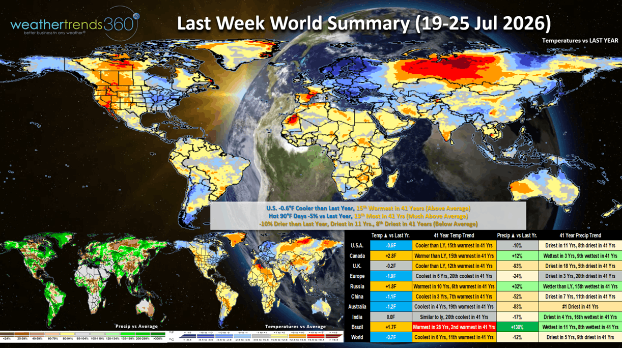
Last week (19-25 July) across the World shows the U.S. trending -0.6F cooler than last year and 15th warmest of the past 41 years. Very cool conditions in the East with some mornings dipping into the 40s and 50s. Hot 90F days nationally were down -5% vs last year and 13th most in 41 years. Rainfall was down -10% vs last year, driest in 11 years and 8th driest in 41 years. This time of year, we start to transition where cold/wet is better for retailers as they start to roll out Back2School merchandise. Europe got a much needed reprieve from the heat! Extremely dry across Australia but wettest in 11 years for Brazil.
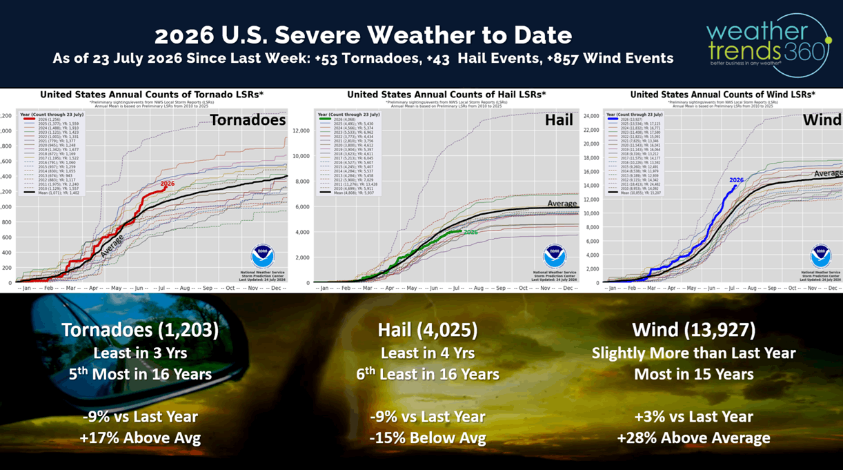
The U.S. added 53 tornadoes last week, only 43 hail events but a more significant 857 wind events. Season to date is still trending down for tornadoes and hail vs last year, but tornadoes and wind cases are still well above average, especially wind which is the most in 15 year.
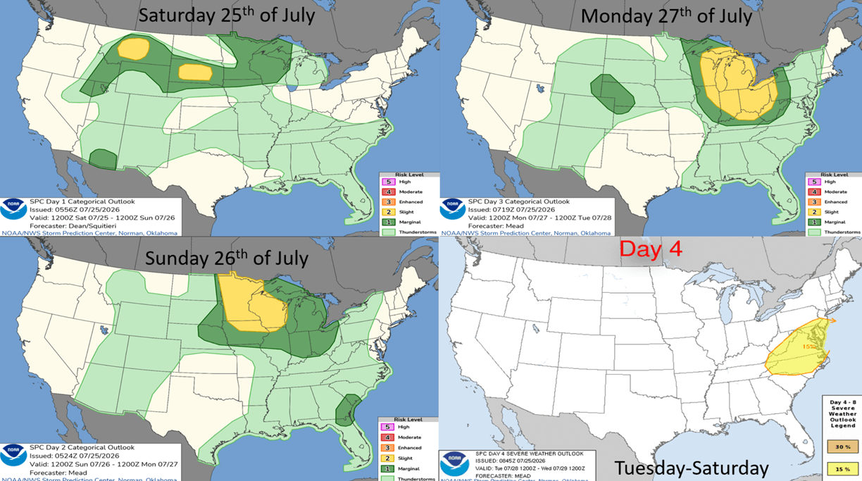
This week the severe weather threat is along the northern border moving into the Great Lakes and Middle Atlantic early in the week.
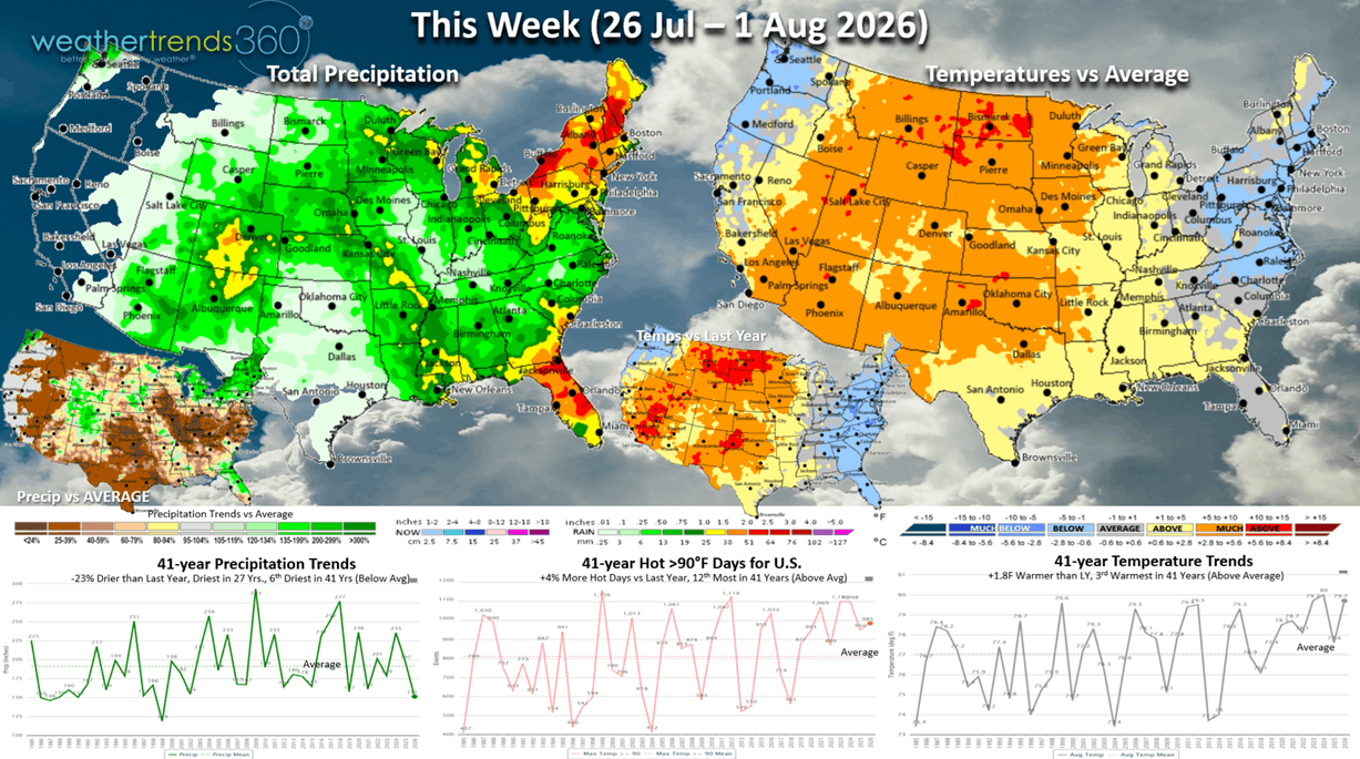
This week (26 Jul - 1 Aug) shows continued cool and wet conditions along the East Coast, hot in the Central U.S. and Rockies with little if any rainfall relief for the fires in the Northwest. Florida likely to get some much needed rain. The U.S. overall trends +1.8F warmer than last year, 3rd warmest in 41 years, hot 90F days up +4% vs last year, 12th most in 41 years, while rainfall is down -23% vs LY, least in 27 years and 6th least in 41 years. Cooler/Wetter is the more favorable weather for back2school sales with kids starting school in early to middle August across the South.
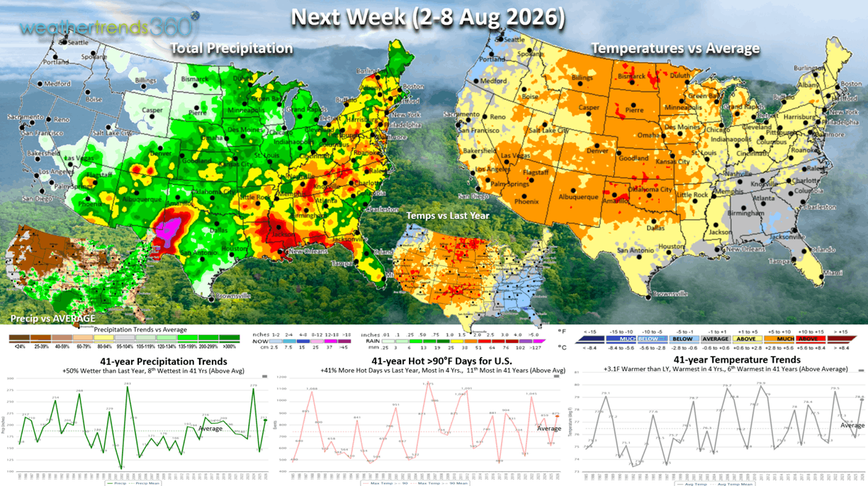
Next week (2-8 Aug) shows temperatures warming in the Northeast but still cooler/wetter in the Southeast. Hottest conditions in the Central Plains. The U.S. overall trends +3.1F warmer than last year, warmest in 4 yrs and 6th warmest of the past 41 years. Hot 90F days are up +41% vs LY, most in 4 yrs and 11th most in 41 years, while rainfall is up +50% vs LY and 8th wettest of the past 41 years. Still no rain for the West Coast so the wildfire risk will increase!
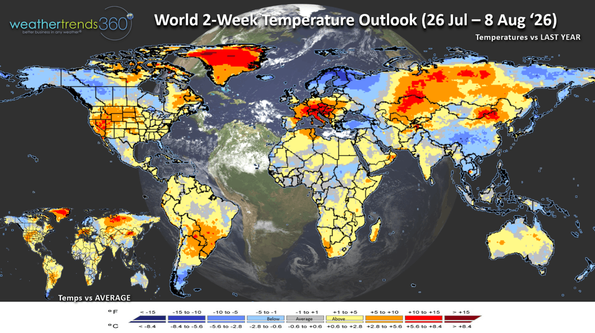
The World 2-week Temperature Outlook (26 Jul - 8 Aug) shows cool conditions for Alaska and Northern Canada, Northern Europe and Southern China. Hot conditions return to Central Europe and the Southwest U.S. Northern Plains.
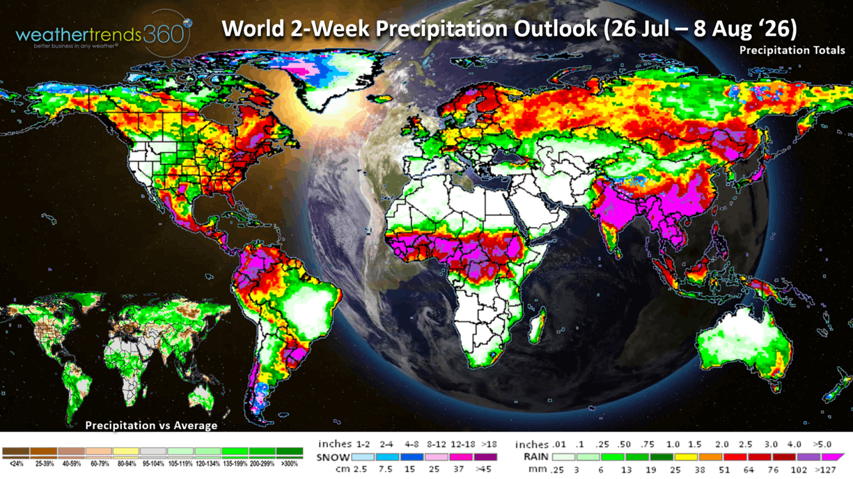
The World 2-week Precipitation Outlook (26 Jul - 8 Aug) shows the Eastern U.S. the wet spot but very dry across most of Europe. Wetter weather returns to Australia for their mid-Winter period.
You can get this blog in your email inbox every weekend (FREE) via subscription.
Have a great week ahead, and don't forget to follow us on social media for updates: Facebook, Twitter(X), YouTube, Pinterest and Linkedin.
- Captain Kirk out (USAF Gulf War Veteran 1989-1999)