wt360 Weather Brief 31 Jan '26 - East Coast Coldest start to FEB in 41+ Years
Captain's Log
31 Jan '26: Happy Saturday! :)
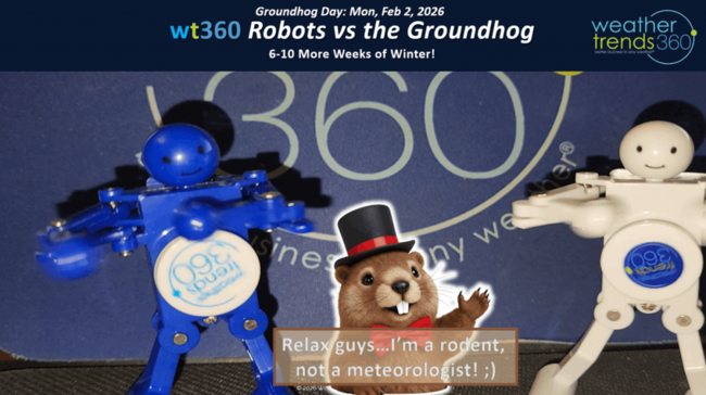
Can you believe Groundhog Day is Monday...likey to be mostly cloudy with some flurries, if Punxsutawney sees his shadow that means 6-more weeks of Winter, no shadow Spring is near! Don't bet on an early Spring! CLICK ON IMAGES FOR A LARGER VIEW
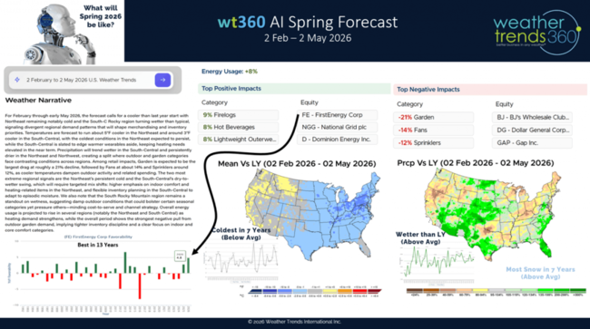
Checking the wt360iQ AI robot we see a much more robust Spring outlook and it's not good if you like nice warm, sunny, dry weather. wt360 is projecting the coldest and snowiest Spring into early May in 7 years for the U.S. overall and wetter than a year ago. Not good for retailers and seasonal suppliers. It is good news for energy companies but bad for consumers facing HUGE energy bills this Winter in the Eastern half of the U.S.
We release our FarmCast 2026 World Ag Outlook video a couple weeks ago, it's now live on our YouTube channel. As expected, it's been very wet in Brazil so very likely they'll have near record crops again this year after a record crop last year. This will create some price pressures for commodities like Corn.

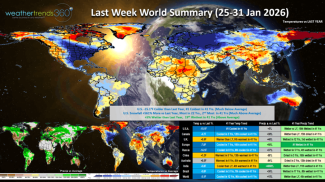
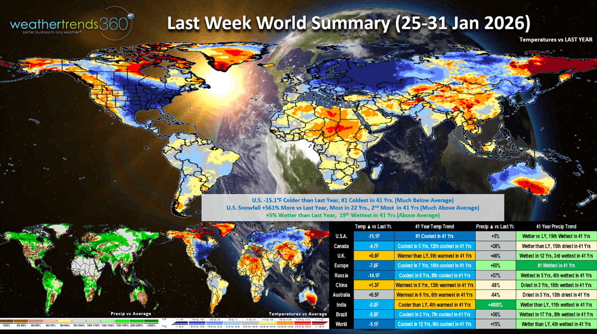
Last week (25-31 Jan) across the World shows the U.S. having very unfavorable weather for retailers with temperatures trending a whopping -15.1F colder than last year and #1 coldest in over 41 years with near 100 year record cold benefiting auto batteries, heaters, hot beverages, snowmelt, tires, etc. Snowfall from the New Mexico to Maine snowstorm resulted in +561% more snow than last year and the most in 22 years, while rainfall was up +5% and 19th wettest of the past 41 years. These are very unfavorable trends for store traffic to Q4 for most companies. Canada and Europe also very cold while it was still wet in Brazil - wettest in 17 years. Clear sign that El Niño is the next evolving weather pattern.
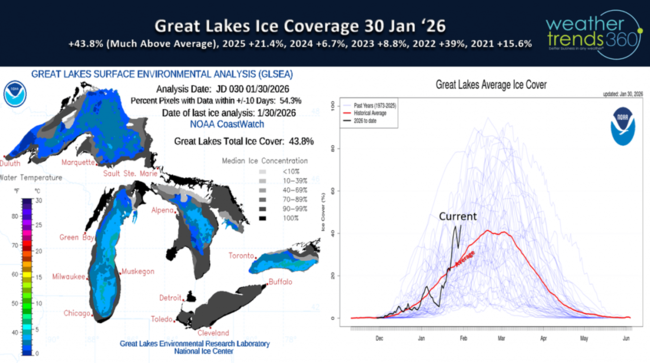
 The frigid latter half of January has the Great Lakes covered in 43.8% ice, well above average and the most in many years. Heavy ice cover on the Lakes tends to prolong the downstream cold well into Spring.
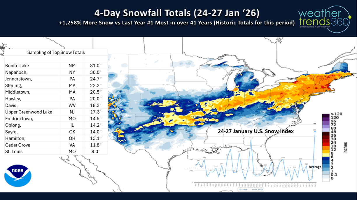
A recap of the 24-27 January snowstorm shows 1-3 feet snow totals from New Mexico to Maine with the U.S. snow index up a whopping +1,258% from last year and snowiest late January period in 5 years.

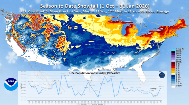
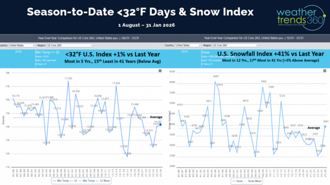
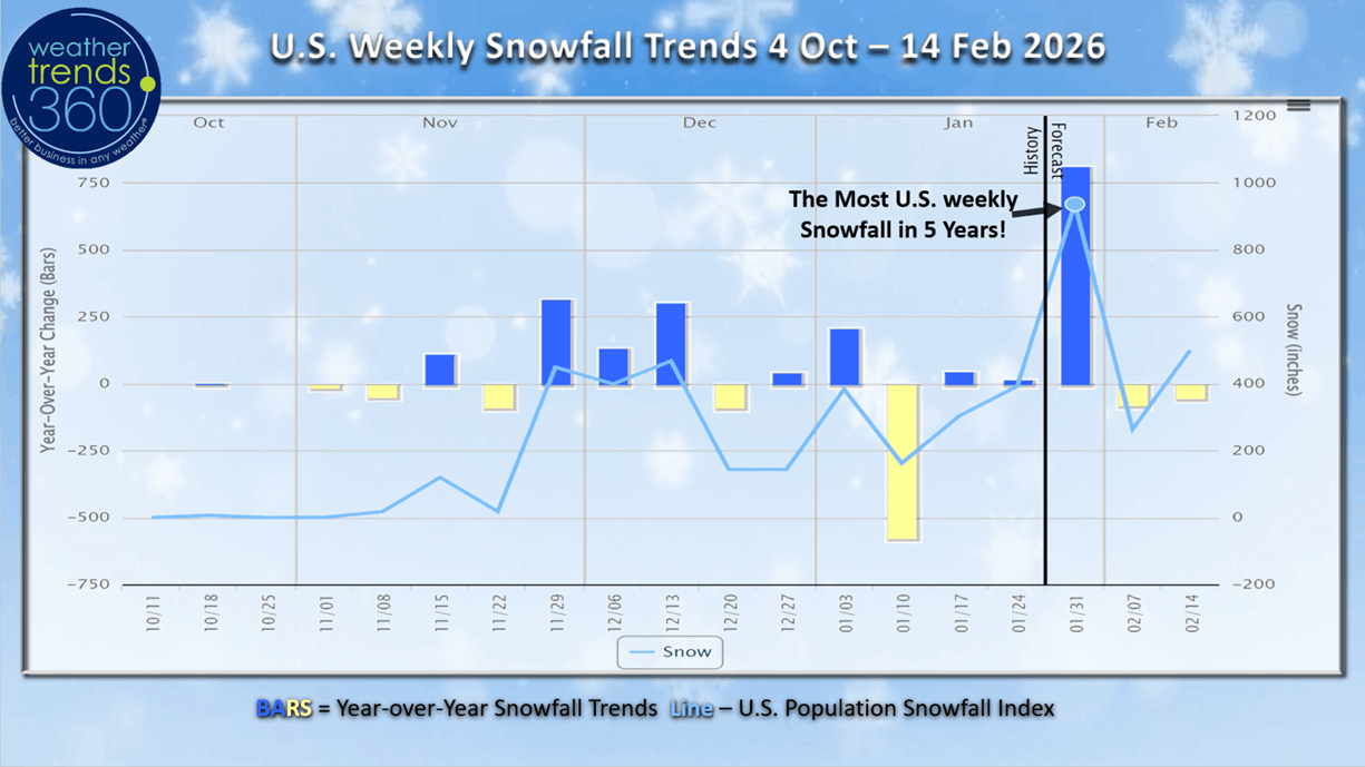
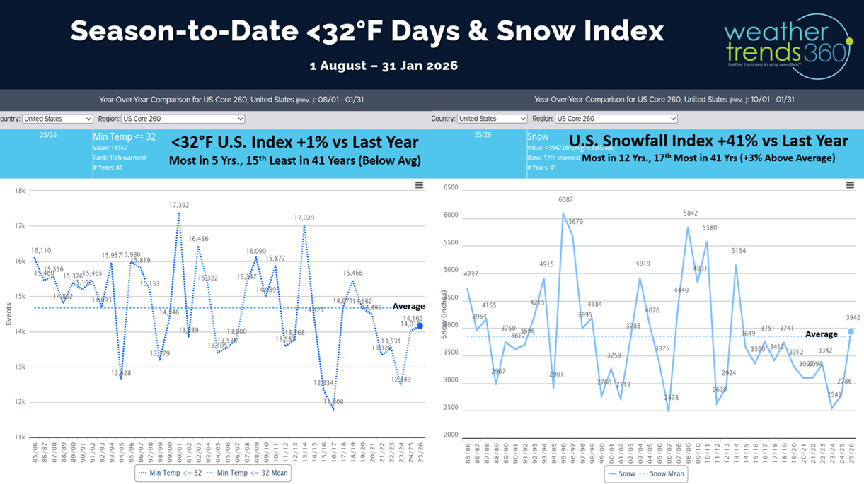
Season-to-date U.S. snowfall is now trending +41% more than last year, most in 12 years and 17th most in 41 years. Much above average in the Great Lakes and East, but below average for most out West.
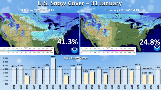
Snow cover Saturday morning across the U.S. is at 41.3% of the U.S. with snow on the ground vs only 24.8% last year. This is the most coverage in 3 years and above the average of 39%.
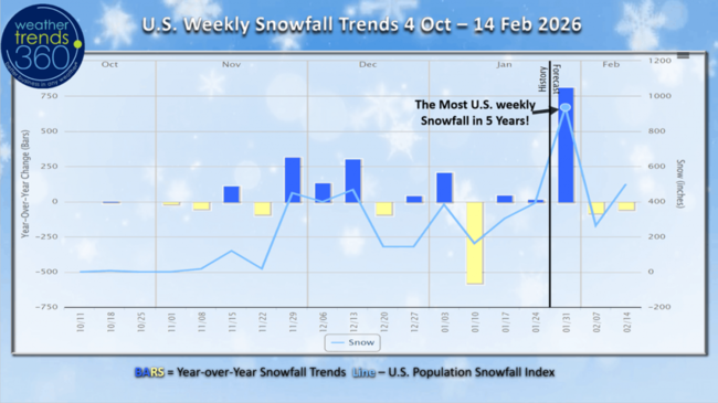
This past week very likely to end up as the snowiest week of Winter as it was the snowiest week for any Winter week going back 5 years. This brought huge demand for snow accessories but also resulted in a lot of stock outs and missed opportunities.
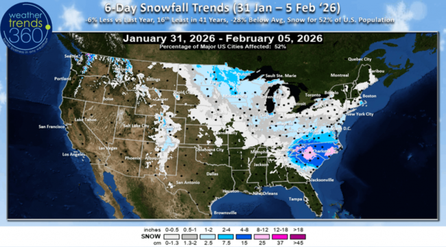
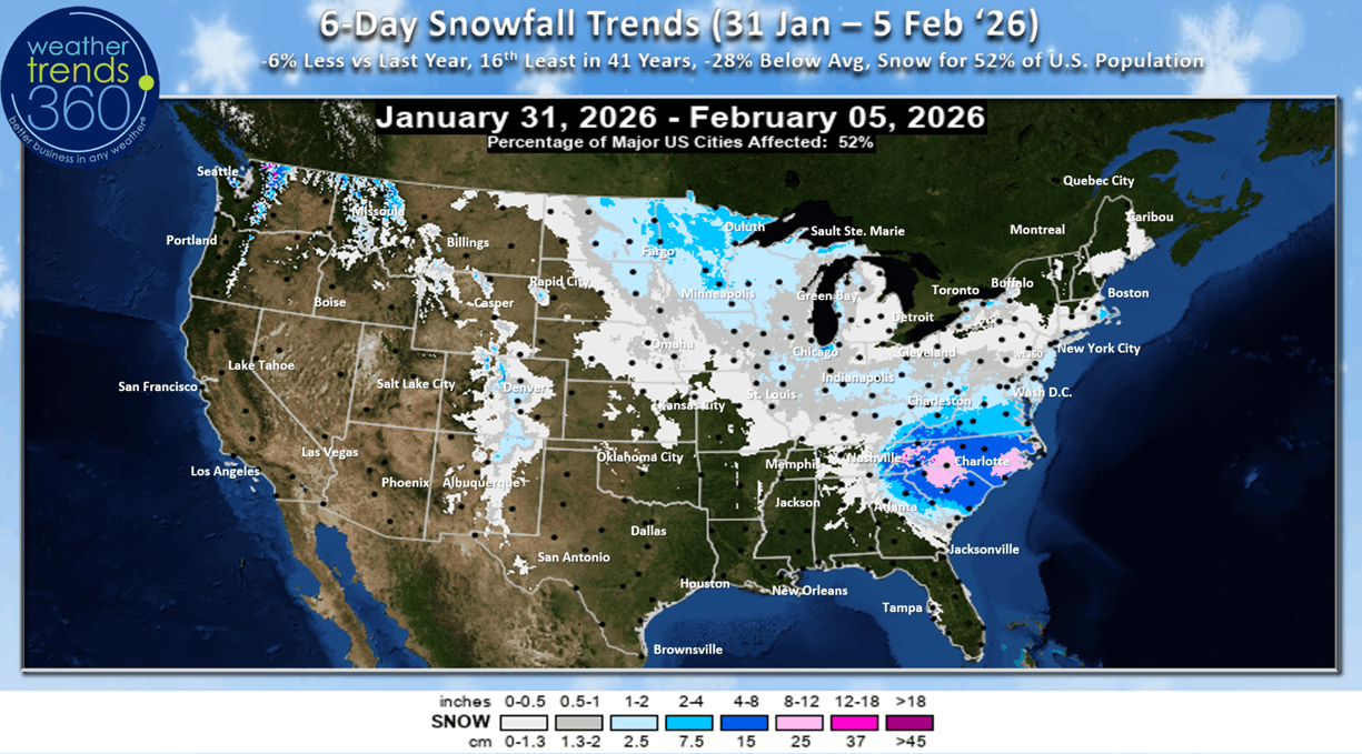
The 6-day outlook (31 Jan - 5 Feb) shows the coastal storm impacting the Carolinas and then some lighter Clipper like storms midweek. Overall snowfall for the 6-day period is expected to be -6% vs last year and 16th least in 41 years, but 52% of the U.S. getting some snow.
The U.S. cold 32F day index had a big uptick and now trending +1% over last year, most in 5 years, but still 15th least in 41 years. This will continue to trend up.
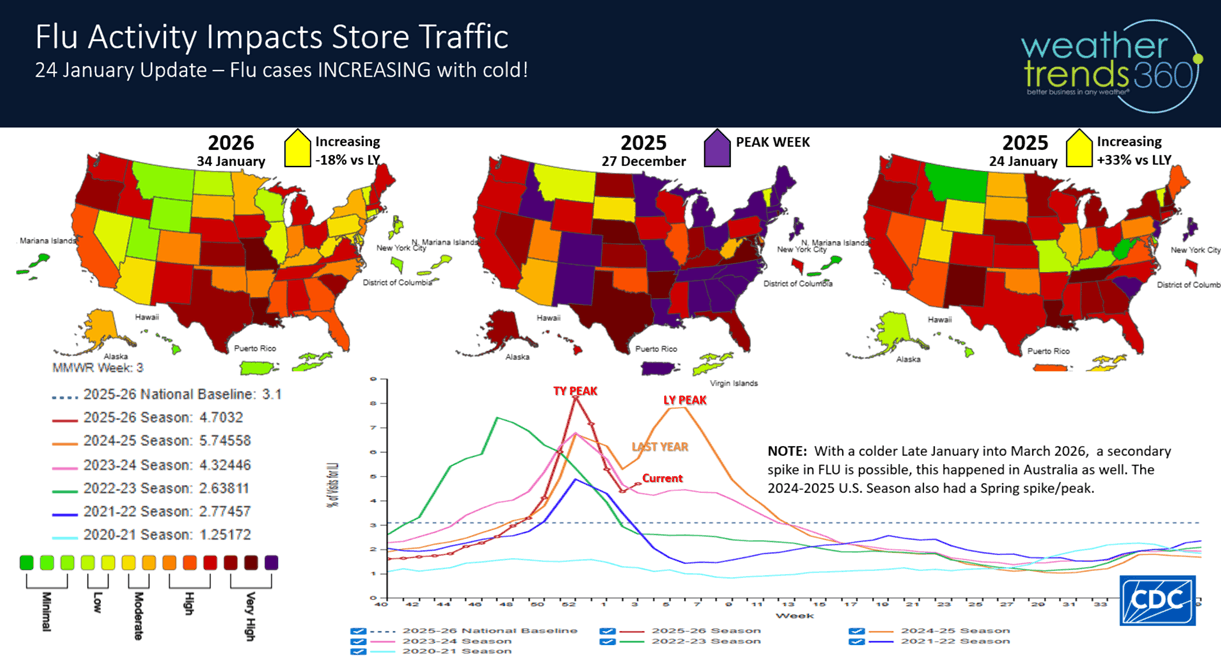
With the big surge in cold weather, FLU made an uptick as well after declining for three weeks. Very possible we get another secondary spike in February, a similar pattern happened in Australia with their past Winter.

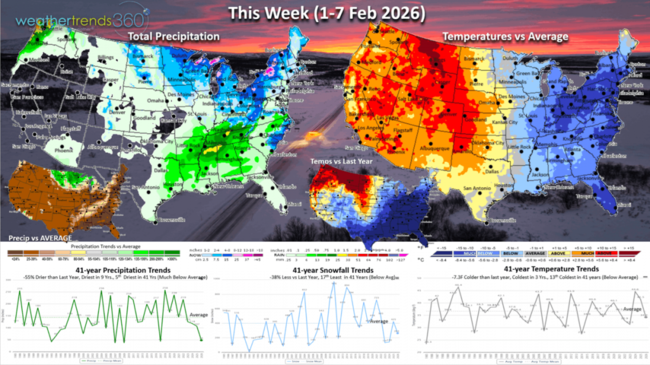
This week (1-7 Feb) shows the same old pattern with warm/dry West, frigid/stormy East. The U.S. overall trends -7.3F colder than last year, coldest in 3 years and 13th coldest in 41 years. Snowfall down -38% vs LY and 17th least of the past 41 years, while rainfall is also down -55% and driest in 9 years. The most favorable area for store traffic is in the West, very unfavorable East.
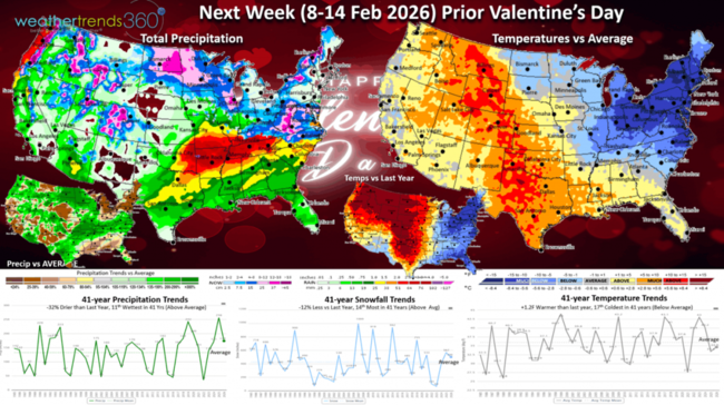
Next week (8-14 Feb) prior Valentine's Day and President's Day remains stuck in a rut, but the U.S. overall finally trends +1.2F warmer than a year ago and 17th coldest in 41 years. Snowfall down -12% but still 14th most in 41 years, while national rainfall is down -32% but still 11th wettest in 41 years. The West is stormier despite milder conditions, overall a soft period for seasonal sales.
The World 2-week (1-14 Feb) Temperature outlook shows the same general pattern of colder Eastern North America, warm West and generally cold Eastern Europe.
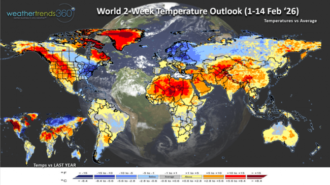
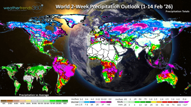
The World 2-week (1-14 Feb) Precipitation outlook shows above average precipitation across Europe, most of Brazil and key growing regions and more mixed across the U.S. with heavy snow for much of Canada.
You can get this blog/video in your email inbox every Saturday (FREE) via subscription.
Have a great week ahead, and don't forget to follow us on social media for updates: Facebook, Twitter(X), YouTube, Pinterest and Linkedin.
- Captain Kirk out (USAF Gulf War Veteran 1989-1999)
Can you believe Groundhog Day is Monday...likey to be mostly cloudy with some flurries, if Punxsutawney sees his shadow that means 6-more weeks of Winter, no shadow Spring is near! Don't bet on an early Spring! CLICK ON IMAGES FOR A LARGER VIEW

Checking the wt360iQ AI robot we see a much more robust Spring outlook and it's not good if you like nice warm, sunny, dry weather. wt360 is projecting the coldest and snowiest Spring into early May in 7 years for the U.S. overall and wetter than a year ago. Not good for retailers and seasonal suppliers. It is good news for energy companies but bad for consumers facing HUGE energy bills this Winter in the Eastern half of the U.S.

We release our FarmCast 2026 World Ag Outlook video a couple weeks ago, it's now live on our YouTube channel. As expected, it's been very wet in Brazil so very likely they'll have near record crops again this year after a record crop last year. This will create some price pressures for commodities like Corn.

Last week (25-31 Jan) across the World shows the U.S. having very unfavorable weather for retailers with temperatures trending a whopping -15.1F colder than last year and #1 coldest in over 41 years with near 100 year record cold benefiting auto batteries, heaters, hot beverages, snowmelt, tires, etc. Snowfall from the New Mexico to Maine snowstorm resulted in +561% more snow than last year and the most in 22 years, while rainfall was up +5% and 19th wettest of the past 41 years. These are very unfavorable trends for store traffic to Q4 for most companies. Canada and Europe also very cold while it was still wet in Brazil - wettest in 17 years. Clear sign that El Niño is the next evolving weather pattern.
 The frigid latter half of January has the Great Lakes covered in 43.8% ice, well above average and the most in many years. Heavy ice cover on the Lakes tends to prolong the downstream cold well into Spring.
A recap of the 24-27 January snowstorm shows 1-3 feet snow totals from New Mexico to Maine with the U.S. snow index up a whopping +1,258% from last year and snowiest late January period in 5 years.
Season-to-date U.S. snowfall is now trending +41% more than last year, most in 12 years and 17th most in 41 years. Much above average in the Great Lakes and East, but below average for most out West.

Snow cover Saturday morning across the U.S. is at 41.3% of the U.S. with snow on the ground vs only 24.8% last year. This is the most coverage in 3 years and above the average of 39%.

This past week very likely to end up as the snowiest week of Winter as it was the snowiest week for any Winter week going back 5 years. This brought huge demand for snow accessories but also resulted in a lot of stock outs and missed opportunities.
The 6-day outlook (31 Jan - 5 Feb) shows the coastal storm impacting the Carolinas and then some lighter Clipper like storms midweek. Overall snowfall for the 6-day period is expected to be -6% vs last year and 16th least in 41 years, but 52% of the U.S. getting some snow.
The U.S. cold 32F day index had a big uptick and now trending +1% over last year, most in 5 years, but still 15th least in 41 years. This will continue to trend up.
With the big surge in cold weather, FLU made an uptick as well after declining for three weeks. Very possible we get another secondary spike in February, a similar pattern happened in Australia with their past Winter.
This week (1-7 Feb) shows the same old pattern with warm/dry West, frigid/stormy East. The U.S. overall trends -7.3F colder than last year, coldest in 3 years and 13th coldest in 41 years. Snowfall down -38% vs LY and 17th least of the past 41 years, while rainfall is also down -55% and driest in 9 years. The most favorable area for store traffic is in the West, very unfavorable East.

Next week (8-14 Feb) prior Valentine's Day and President's Day remains stuck in a rut, but the U.S. overall finally trends +1.2F warmer than a year ago and 17th coldest in 41 years. Snowfall down -12% but still 14th most in 41 years, while national rainfall is down -32% but still 11th wettest in 41 years. The West is stormier despite milder conditions, overall a soft period for seasonal sales.

The World 2-week (1-14 Feb) Temperature outlook shows the same general pattern of colder Eastern North America, warm West and generally cold Eastern Europe.

The World 2-week (1-14 Feb) Precipitation outlook shows above average precipitation across Europe, most of Brazil and key growing regions and more mixed across the U.S. with heavy snow for much of Canada.

You can get this blog/video in your email inbox every Saturday (FREE) via subscription.
Have a great week ahead, and don't forget to follow us on social media for updates: Facebook, Twitter(X), YouTube, Pinterest and Linkedin.
- Captain Kirk out (USAF Gulf War Veteran 1989-1999)